Trimble’s new GNSS base station gives users improved satellite tracking and remote operation for civil construction, geospatial and agriculture applications
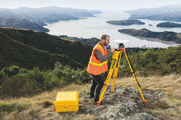
Photo: Trimble
Trimble has introduced the Trimble R750 GNSS modular receiver, a connected base station for use in civil construction, geospatial and agricultural applications. The R750 provides high-accuracy base station performance, giving contractors, surveyors and farmers more reliable and precise positioning in the field.
The R750 can be used to broadcast real-time kinematic (RTK) corrections for a wide range of applications, including seismic surveying, monitoring, civil construction, precision agriculture and more. Access to all available satellite signals provides improved performance and reliability when used with a Trimble ProPoint GNSS rover. ProPoint gives users improved performance in challenging GNSS conditions, with improved signal management.
Featuring a built-in LTE modem, the R750 can provide corrections via the internet, making it easier to extend the range of a base station anywhere with cellular coverage. The built-in modem also provides remote access and management, delivery of email alerts and notifications, and data transfer capabilities between the field and the office.
“The R750 delivers significantly improved satellite tracking and connectivity, while also providing a vastly improved user experience,” said Scott Crozier, vice president of Trimble Construction Field Solutions. “The ability to manage the base station remotely, and to receive status notifications about the unit while in the office reduces downtime and the need to travel to the site. The new Trimble R750 is a game changer, especially for users who manage base stations in remote locations.”
For monitoring applications, the R750 provides precision capabilities for construction and geospatial customers deploying automated systems. Combined with Trimble 4D Control real-time monitoring software, users can capture high-frequency 3D positions for alarming and reporting on movement. The R750 offers multiple communication methods that provide flexibility for customers on how they deploy their monitoring system.
Tallysman, a manufacturer of high-performance GNSS antennas and related components, has introduced a high-accuracy choke ring antenna: the Tallysman VeraChoke.
Adapting existing innovations on its patented VeraPhase antenna, Tallysman’s VeraChoke offers a choice in form factor for reference and monitoring applications.
The VC6100, the first model variant of the VeraChoke antenna, shares a common high-efficiency element design with itsVeraPhase counterpart. With the choke-style form-factor, however, the rings have been optimized for all GNSS signals and are slightly pyramidal in shape to improve reception of low-elevation satellites.
The VC6100 choke ring antenna offers a tight phase center variation of no more than ±1 mm for every frequency. It is capable of receiving all GNSS signals and achieves a very low axial ratio, the company said.
According to Tallysman, the VC6100 is competitively priced to help increase antenna density for reference deployments, CORS networks and monitoring applications. The antenna also supports large and small SCIGN radomes.
Tallysman’s GNSS antennas are on display at Booth Number 12.0D.059 at Intergeo, taking place Oct. 16-18 in Frankfurt, Germany.
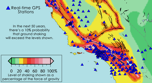
Location of the more than 500 real-time GPS monitoring stations in the western United States that make up the Real-Time Earthquake Analysis for Disaster Mitigation Network. Image credit: USGS/UC Berkeley/Scripps Institution of Oceanography.
The space-based technology that lets GPS-equipped motorists constantly update their precise location will undergo a major test of its ability to rapidly pinpoint the location and magnitude of strong earthquakes across the western United States, according to NASA. Results from the new Real-time Earthquake Analysis for Disaster (READI) Mitigation Network soon could be used to assist prompt disaster response and more accurate tsunami warnings.
The new research network builds on decades of technology development supported by the National Science Foundation, the Department of Defense, NASA and the U.S. Geological Survey (USGS). The network uses real-time GPS measurements from nearly 500 stations throughout California, Oregon and Washington. When a large earthquake is detected, GPS data are used to automatically calculate its vital characteristics, including location, magnitude and details about the fault rupture.
“With the READI network, we are enabling continued development of real-time GPS technologies to advance national and international early warning disaster systems,” said Craig Dobson, natural hazards program manager in the Earth Science Division at NASA Headquarters in Washington. “This prototype system is a significant step towards realizing the goal of providing Pacific basin-wide natural hazards capability around the Pacific ‘Ring of Fire.’”
Accurate and rapid identification of earthquakes of magnitude 6.0 and stronger is critical for disaster response and mitigation efforts, especially for tsunamis. Calculating the strength of a tsunami requires detailed knowledge of the size of the earthquake and associated ground movements. Acquiring this type of data for very large earthquakes is a challenge for traditional seismological instruments that measure ground shaking.
High-precision, second-by-second measurements of ground displacements using GPS have been shown to reduce the time needed to characterize large earthquakes and to increase the accuracy of subsequent tsunami predictions. After the capabilities of the network have been fully demonstrated, it is intended for use by appropriate natural hazard monitoring agencies. The USGS and the National Oceanic and Atmospheric Administration are responsible for detecting and issuing warnings on earthquakes and tsunamis, respectively.
“By using GPS to measure ground deformation from large earthquakes, we can reduce the time needed to locate and characterize the damage from large seismic events to several minutes,” said Yehuda Bock, director of the Scripps Institution of Oceanography’s Orbit and Permanent Array Center in La Jolla, Calif. “We now are poised to fully test the prototype system this year.”
The READI network is a collaboration of many institutions, including Scripps at the University of California in San Diego; Central Washington University in Ellensburg; the University of Nevada in Reno; California Institute of Technology/Jet Propulsion Laboratory in Pasadena; UNAVCO in Boulder, Colo.; and the University of California at Berkeley.
NASA, NSF, USGS and other federal, state and local partners support the GPS stations in the network, including the EarthScope Plate Boundary Observatory, the Pacific Northwest Geodetic Array, the Bay Area Regional Deformation Array and the California Real-Time Network.
“The relatively small investments in GPS-based natural hazards systems have revolutionized the way we view Earth and allowed us to develop this prototype system with great potential benefits for the infrastructure and population in earthquake-prone states in the western United States,” said Frank Webb, Earth Science Advanced Mission Concepts program manager at JPL.
The READI network is the outgrowth of nearly 25 years of U.S. government research efforts to develop the capabilities and applications of GPS technology. The GPS satellite system was created by the Department of Defense for military and ultimately civil positioning needs. NASA leveraged this investment by supporting development of a global GPS signal receiving network to improve the accuracy and utility of GPS positioning information. Today that capability provides real-time, pinpoint positioning and timing for a wide variety of uses, from agriculture to Earth exploration, NASA said.
“Conventional seismic networks have consistently struggled to rapidly identify the true size of great earthquakes during the last decade,” said Timothy Melbourne, director of the Central Washington University’s Pacific Northwest Geodetic Array. “This GPS system is more likely to provide accurate and rapid estimates of the location and amount of fault slip to fire, utility, medical and other first-response teams.”
The GPS earthquake detection capability was first demonstrated by NASA-supported research on a major 2004 Sumatra quake, conducted by Geoffrey Blewitt and colleagues at the University of Nevada in Reno.