Tag: multi-constellation receiver

  • GNSS module from STMicroelectronics leverages Teseo III chip

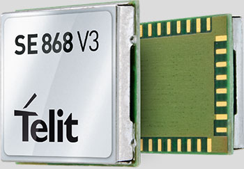
    STMicroelectronics (ST) is making its Teseo III satellite navigation receiver accessible to a wider designer community by introducing the Teseo-LIV3F module, which integrates essential features to speed application development and also adds up to 16 MB of Flash memory for firmware updating or data logging without a backup battery.

    Used by automotive and industrial sectors, ST’s Teseo III multi-constellation receiver combines high accuracy with fast response time and low power consumption, the company said.

    The Teseo-LIV3F module now enables makers and small engineering teams without extensive in-house RF expertise to leverage the Teseo III advantages in creating new products in the industrial and consumer market segments such as vehicle trackers, drones, anti-theft devices and pet locators, and systems for services such as fleet-management, tolling, vehicle sharing or public transportation.

    The 18-pin, 9.7 x 10.1 millimeter module contains the Teseo III receiver with on-chip power management, UART and I2C interfaces, alongside the Flash memory, an ultra-stable temperature-controlled crystal oscillator (TCXO), and 32kHz real-time clock (RTC).

    The documentation and tools delivered with the module contain all the C code needed to drive the module using the STM32 microcontroller, including the use of data-logging, odometer and geofencing to aid development of value-added functionality.

    While simplifying application development, Teseo-LIV3F delivers high performance, including -163 dBm tracking sensitivity and 1.5m positioning accuracy (CEP Circular Error Probability) and low-power operation (17µW in standby mode and 75mW when tracking). FCC and CE certifications streamline product testing and accelerates time to market.

    Multi-constellation flexibility ensures robust, failure-resistant navigation worldwide, with access to the GPS, GLONASS, Galileo and BeiDou constellations, as well as the Pacific-region Quasi-Zenith Satellite System (QZSS).

    The module supports assisted modes — including autonomous ST Assisted GPS (STAGPS) and server-based assisted-GNSS with free server access — to retrieve ephemeris data if satellites are unavailable for fast time to first fix (TTFF). The module also supports standardized augmentation systems to enhance accuracy, including the U.S., European, Japanese/South-East Asia, and Indian Satellite-Based Augmentation Systems (SBAS), and the Radio Technical Commission for Maritime Services (RTCM) differential GPS.

    The Teseo-LIV3F module is available now as an 18-pin LLC device.

  • OriginGPS Introduces Modules to Support GPS, GLONASS and BeiDou with MediaTek

    OriginGPS has launched a new family of products, the first of which is the ORG1510-MK Multi Micro Hornet, a fully integrated multi-GNSS (GPS, GLONASS and BeiDou) module. The miniature low-power architecture supports an update rate of up to 10 Hz and contains onboard flash. It is designed to provide a GNSS component to devices that require fully featured components with small footprints, such as UAVs designed to follow action sports and other fast-moving activities or wearables.

    OriginGPS released the Multi Micro Hornet (ORG1510-R01) in June, which tracks GPS and GLONASS, but not BeiDou. The ORG1510-R01 uses a SiRFstarV GNSS system on chip.

    The ORG1510-MK contains the MediaTek MT3333 chip, which supports a fast update position calculation rate. The chip also contains an onboard flash memory that does not erase when power is off. It consumes very little power with the use of both standby mode and backup mode, and, in advanced applications, a periodic mode that can turn the device on and off when in backup or standby.

    “The inclusion of MediaTek has enabled the creation of the most powerful GPS module on the market,” said Gal Jacobi, CEO of OriginGPS. “The ORG1510-MK’s tremendously fast update rate, low power consumption, miniature size and reliable accuracy makes it possible to track life’s most exciting and fast-paced activities without delay, battery drain, or clunky devices. It will be a meaningful engine of growth for OriginGPS in Asia Pacific and globally.”

    Key features of the New Multi Micro Hornet include:

    Rapid update rate and superior memory – The Multi Micro Hornet has an update rate of up to 10 Hz and onboard flash, supporting a significantly higher accuracy than the standard update rate of 1 Hz and low power consumption due to the module’s ability to store hours of data.

    Smallest size, highest performance – Despite the Multi Micro Hornet’s tiny size of 10 x 10 mm and height of 6.1 mm, the module offers superior sensitivity and outstanding performance, achieving rapid time to first fix (TTFF) of less than 1 second, accuracy within as little as 1 meter, and sensitivity at -165 dBm for two constellations simultaneously.

    High sensitivity and noise immunity – The ORG1510-MK continues to leverage OriginGPS’ patented and proprietary Noise Free Zone (NFZ) technology to ensure high sensitivity and noise immunity even under marginal signal conditions.

    Continuous connectivity with minimal power consumption – The low power consumption modes aided by MediaTek include a standby mode, during which the RF and baseband enter low power mode, and backup mode, during which the internal PMU turns off and only keeps the VRTC domain alive. For advanced applications, the module can periodically turn its operation on and off when in backup or standby mode.

    An intelligent design that shortens time to market – The Hornet family of GPS / GNSS antenna modules integrates a GNSS receiver and patch antenna in a single module. As a cornerstone of the OriginGPS portfolio, the ORG1510-MK pin-to-pin compatibility with the Micro and Nano Hornet modules ensures a seamless migration from GPS to GNSS and gives developers the ability to create new product offerings in the shortest time to market while minimizing costly design risks. Developers can simply connect it to a power source on a single layer PCB to begin integrating it into their designs.

    The ORG1510-MK module combines OriginGPS’ proprietary low-profile GNSS antenna with a dual-stage LNA, RF LDO, SAW filter, TCXO, RTC crystal and RF shield.

  • Unicore Releases GNSS High-Precision Board

    Unicore has released the UB380 GPS/GLONASSS/BDS high-precision board at ION GNSS+ 2015, held this week in Tampa, Fla.

    UB380 is a multi-GNSS receiver that supports GPS, GLONASS and BDS. It is based on Unicore’s mature multi-GNSS system on chip (SoC). UB380 is designed for high-precision positioning, navigation and GBAS applications.

    UB380 can track GPS L1, L2, L5; GLONASS L1, L2; and BDS B1,B2, B3 (support) — the support of GPS L2P, L2C can satisfy the high-precision requirements of GBAS reference station equipment.

    With the latest tri-frequency RTK engine, UB380 can process tri-frequency of BDS and GPS, and the dual-frequency of GLONASS observation data, which can significantly reduce initialization time, improve position accuracy, and enhance reliability in difficult environments such as in urban canyons and under tree canopy, as well as make long baseline RTK possible.

    Source: GPS world staff
    The UR380 GNSS receiver with UB380 inside.

    UB380 is compatible with industry-standard GNSS boards in size, interfaces and electrical standards.

    Features of UB380:

    • 384 channels, support for BDS B1/B2/B3 + GPS L1/L2/L5 + GLONASS L1/L2
    • Better than 1-mm carrier-phase precision
    • Centimeter-level high-precision RTK positioning
    • Better than 0.2° heading accuracy
    • Compatible with industry standard GNSS boards
  • Septentrio Launches AsteRx-U and AsteRx-U Marine

    AsteRxU_left_orientation-W

    Septentrio this week is launching two successors to its APS-U: The AsteRx-U and the AsteRx-U Marine multi-constellation dual-antenna receivers. The AsteRx-U will be presented to the public for the first time at two trade shows this week. ION GNSS+ takes place Sept.14-18 in Tampa, Fla., and INTERGEO 2015 will be held in Stuttgart, Germany, Sept. 14-18.

    The AsteRx-U and the AsteRx-U Marine incorporate the latest GNSS tracking and positioning algorithms and interference mitigation. Machine-control users in the agricultural and construction industries, as well as users in marine and mining industries, benefit from a complete system with integrated UHF radio, Wi-Fi, USB, Bluetooth and cellular connectivity and a spectrum analyzer, Septentrio said. All configurations can be done via the on-board web interface.

    The AsteRx-U and AsteRx-U Marine feature a full range of positioning techniques and algorithms to ensure that users have the highest accuracy and reliability. The spectrum analyzer enables users to visualize the RF spectrum. Based on its extensive experience with real-life interference sources and their mitigation, Septentrio has developed interference mitigation technology that automatically counteracts various kinds of ambient intentional and unintentional RF interference.

    The AsteRx-U family of receivers is built around Septentrio’s latest ASIC, GReCo4, which was introduced in 2014. It incorporates built-in jamming detection and countermeasures, multi-path rejection, fast acquisition and other advanced features. Both receivers have more than 500 hardware channels to track all available constellations (GPS, GLONASS, Galileo, Beidou, IRNSS and QZSS) and feature many algorithms: LOCK+ technology to maintain tracking during heavy vibration machine use and IONO+ technology to assure the accuracy of the position even in regions of elevated ionospheric activity.

    The AsteRx-U has decimeter- and centimeter-level RTK positioning including TerraStar. The AsteRx-U Marine also supports Veripos PPP augmentation services. It includes extra anti-jamming technology to counter Iridium and INMARSAT-uplink interference, as well as an extra antenna connector for a dedicated L-band antenna to optimize L-band reception at high latitudes.

    Straightforward to set up and integrate with existing systems, the AsteRx-U and AsteRx-U Marine use any device with a web browser to facilitate usability and configuration for the user.

    “We want to make it easy for our customers to use high-accuracy positioning in their work,” said Jan Leyssens, Septentrio product manager. “Using the integrated communication functionality in the compact and portable AsteRx-U, users won’t have to worry about adding their own modems or UHF radios to get access to corrections.”

    Leyssens continued, “The receiver web interface is available wirelessly on any mobile device. It was designed together with several of our key customers, resulting in an interface that is not only easy to use by field operators, but also provides many useful troubleshooting tools, such as the spectrum analyzer, to solve problems in the field and minimize downtime.”

    Septentrio will be at Booth 318 at ION GNSS+, and at Hall: 4, Booth: D4.014, at INTERGEO.

  • QinetiQ Announces Robust GNSS Receiver for Galileo PRS

    QinetiQ Announces Robust GNSS Receiver for Galileo PRS

    The QinetiQ PRS receiver.
    The QinetiQ PRS receiver.

    QinetiQ today announced a major breakthrough in developing a robust navigation receiver that will use the Galileo, Europe’s satellite navigation system — in particular, the secured Public Regulated Service (PRS).

    QinetiQ’s new high-performance, next-generation GNSS receiver is multi‑constellation and multi‑frequency, and is designed to process encrypted signals from the Galileo PRS service as well as open services such as GPS. Qinetiq introduced the receiver today at the UK Space Conference, being held July 13-15 in Liverpool.

    The receiver — now a in prototype form — is a significant step towards developing an end-user product for navigation, tracking and timing, QinetiQ said. It will offer highly secure, accurate and reliable position, velocity and timing intended for users with a mission-critical need such as governments, the military and emergency services across Europe. 

    “We are delighted that, after years of QinetiQ R&D and collaboration with the EU, European Space Agency (ESA) and UK government, we have achieved this major step towards our goal of offering robust navigation products using Galileo,” said Nigel Davies, head of QinetiQ’s Secured Navigation Group. “It is a significant breakthrough for us to have built a fully operational receiver on a platform, which proves our product architecture, functionality and algorithms.”

    “Our next step will be working to refine the product family and preparing it to be brought to market, which includes developing additional features and reducing its size to that of a postage stamp, in a form factor similar to our existing, highly successful Q20 receiver,” Davies said. “We have full confidence in this product and are proud to be at the forefront of this exciting new phase in European navigation.”

    The prototype receiver is a multi-constellation, multi-frequency, all‑in‑view receiver that can receive and process the Galileo PRS as well as Galileo Open Service and GPS Standard Positioning Service. It is also designed to utilize other GNSS signals including the Russian GLONASS and Chinese Beidou systems as well as space-based augmentation services (SBAS) such as WAAS and EGNOS.  

    The receiver, which is based on the military standard SEM-E form factor, is also designed for integration into multi-sensor navigation systems and is designed to provide high levels of protection against jamming and spoofing.  It has a fast acquisition capability and is designed for government security accreditation.

    It is expected that a suite of robust products will be ready by 2020 to coincide with the completion of the Galileo project, which will be the world’s third GNSS to be completed after the United States and Russian systems.

    The new receiver is part of a long pedigree in robust GNSS receivers. Q20 was QinetiQ’s first GPS receiver, designed for specific challenging applications: high dynamics, or high sensitivity like tracking from inside a shipping container. QinetiQ’s family of receivers will include two new products based on the new receiver. Q40 will be QinetiQ’s next-generation robust open service receiver, which will be a multi‑constellation, multi‑frequency open-service receiver which can use signals from all of the GNSS open services. Q50 will incorporate all of the functionality of the Q40 receiver, but also offer Galileo PRS for authorized users who need the additional capabilities and robustness.

    “The device we have built is a major stepping stone to Q40 and Q50 as the technology has all been built for the receiver products and is designed to be shrunk on to a single ASIC microchip,” Davies said. “Our focus of attention will now be to turn what we have built into an ASIC product which is ready for market.”

  • Septentrio Completes Acquisition of Altus Positioning

    Septentrio Satellite Navigation has completed the acquisition and integration of Altus Positioning Systems. Septentrio said the acquisition strengthens the company’s focus on highly accurate and reliable GPS/GNSS positioning equipment, and the integrated company will continue to focus on developing emerging markets across the globe and increase advancements in the field of GIS.

    “At the heart of this fusion are our customers,” said  Antoon de Proft, CEO and president of Septentrio, “They will benefit from this unique opportunity, which combines the knowledge and experience of Septentrio in GNSS positioning with experience of Altus-PS in survey, mapping and GIS; and from an expanded offering of products and services under one group.”

    Septentrio Satellite Navigation and Altus-PS started working together in 2007. The collaboration between the two companies resulted in a series of successful products such as the APS-NR2, APS-3, APS-U and APS-GeoPod, surveying and GIS products that provide essential accurate and reliable results and ease of operation, Septentrio said in a statement. The smart antenna products will form a product line in the Septentrio product portfolio.

    The acquisition brings key capabilities and synergies in other areas such as testing, manufacturing and delivery, which will now be based from Septentrio’s corporate headquarters outside the Belgian city of Leuven.

    Neil Vancans
    Neil Vancans

    Neil Vancans, formerly president of Altus-PS, now becomes vice president of Septentrio Americas. “The fusion of our two companies is a logical step in our evolving business relationship and professional collaboration,” Vancans said. “We look forward to leveraging the strengths of both our organizations to grow the market for Septentrio products across a wide range of market sectors and build the same level of success for Septentrio products in the American market that we have enjoyed elsewhere in the world.”

    Septentrio designs, manufactures and sells high-precision multi-frequency, multi-constellation GPS/GNSS equipment used in demanding applications in a variety of industries such as marine, construction, agriculture, survey and mapping, GIS and UAVs. Septentrio receivers are available as OEM boards, housed receivers and smart antennas.

  • Telit GNSS Module Enables High-Performance Position Reporting

    Telit's Jupiter SE868-V3 module.
    Telit’s Jupiter SE868-V3 module.

    Telit Wireless Solutions has released a new GNSS module, the SE868-V3. The positioning module combines GPS, GLONASS, Beidou, Galileo and SBAS, which enables the creation of high-performance position reporting and navigation solutions.

    The SE868-V3 can navigate to -162 dBm and track to -166 dBm, providing improved performance in harsh environments. It is pin-to-pin compatible with the former SE868-V2 as well as the JF2. This advanced GNSS module can track GPS and GLONASS or GPS and Beidou constellations simultaneously and it is Galileo-ready.

    The 11 x 11 mm QFN package contains a powerful baseband processor, SQI Flash memory and GNSS chip with integrated low noise amplifier (LNA). The ultra-sensitive RF front-end enables multi-GNSS indoor fix and high-quality navigation in challenging outdoor scenarios such as dense urban areas, Telit said.

    In addition, the SE868-V3 supports ephemeris file injection (A-GPS) as well as Satellite-Based Augmentation System (SBAS) to increase position accuracy. Its onboard software engine is able to locally predict short-term ephemeris starting from data broadcast by GNSS satellites received by the module and stored in the internal Flash memory.

    “The SE868-V3 is yet another addition to our positioning product portfolio, which is the result of over 20 years of experience in GNSS applications,” said Felix Marchal, chief product officer, Telit. “Our products are compatible with the GPS constellation as well as its Russian counterpart GLONASS and China’s Beidou.”

  • Septentrio Introduces Next-Generation GNSS Receiver, AsteRX4

    Septentrio Introduces Next-Generation GNSS Receiver, AsteRX4

    Septentrio's AsteRx4 OEM.
    Septentrio’s AsteRx4 OEM.

    Septentrio has launched its next-generation dual-antenna GNSS receiver, the AsteRx 4 OEM. The AsteRx 4 OEM is a multi-frequency, dual antenna receiver that incorporates the latest innovative GNSS tracking and positioning algorithms from Septentrio. It offers users in the marine, machine control and agricultural industries precision, accuracy, reliability and ease of use, the company said.

    Thanks to Septentrio’s positioning engine, which uses advanced multipath and ionosphere modeling algorithms, the AsteRx4 offers robust positioning scalable from meter to centimeter accuracy. Together with precise heading and reliable error estimates, the AsteRx 4 OEM functions in tough conditions on land, at sea or in the air.  

    Use of all available constellations (GPS, GLONASS, BeiDou, Galileo) provide the operator with a reliable solution even in obstructed areas such as in narrow city streets or at the corners of large structures, Septentrio said. The AsteRx4 OEM features the full range of positioning techniques from stand-alone to real-time kinematic (RTK).

    For users who operate in more remote regions of the globe, the AsteRx4 OEM supports Veripos and Terrastar correction PPP services. Furthermore, the receiver features special interference mitigation technology which filters out ambient intentional and unintentional RF interference.

    The AsteRx4 OEM is straightforward to set up and integrate with existing systems, Septentrio said. It has the similar hardware interface as earlier AsteRx receivers, and supports the same open and well documented command and binary output format. Users will be able to operate their receiver without special configuration software by using the very accessible web interface, which is available via network and USB connections.

    “AsteRx4 incorporates many powerful improvements based on practical difficulties our customers face in the field every day,” said Jan Van Hees, vice president of Business Development, Septentrio. “We are particularly proud of the solutions for interference robustness that we have incorporated into our new ASIC,  the GReCo4; the solid and reliable positioning algorithms that result from taking the receivers into the most extreme environments and from focusing not only on accuracy, but on reliability of the position solution.”

    The AsteRx4, along with all the AsteRx family of receivers, will be on display at booth W40 for the duration of Ocean Business 2015 starting April 14 at the National Oceanography Centre, Southampton, UK.

  • MWC 2015: Rx Networks Updates GNSS Extended Ephemeris Solution

    Rx Networks Inc., a mobile location technology and services company, announced the upcoming release of its GPStream PGPS v8 extended ephemeris solution at Mobile World Congress 2015, taking place this week in Barcelona, Spain.

    The patented technology, being used in hundreds of millions of devices, is designed to speed up the time-to-first-fix (TTFF) of any GNSS chipset while improving acquisition sensitivity in challenging environments.

    Compared to the previous version, GPStream PGPS v8 effectively doubles accuracy performance while supporting all four global GNSS constellations. GPStream PGPS v8 will be available for integration testing in the second quarter of 2015, with commercial release in the fourth quarter of 2015. (Full commercial support for Galileo will remain subject to the readiness of the constellation).

    All major GNSS semiconductor vendors are now offering or developing multi-constellation support to improve availability in challenging environments. Quad-constellation support also enables OEMs and GNSS chipset manufacturers to meet any national or regional market requirement. Availability of extended ephemeris across the four constellations is required to ensure fast TTFF and optimal sensitivity. Early lab access to the latest GPStream PGPS v8 solution from Rx Networks can help chipset manufacturers validate performance early in the development cycle and thus accelerate the time to market for their new multi-constellation chipsets.

    A key component of any extended ephemeris solution is the accuracy of the orbit and clock predictions. This accuracy is often presented as an error in meters compared to the native broadcast ephemeris transmitted by the satellites. The latest version of GPStream PGPS improves this accuracy by a factor of two, compared to its previous release. For example, day 1, 7 and 14 accuracies for GPS are now 2.8 m, 4.5 m and 11.4 m compared to 6.3 m, 12.5 m and 30.2 m previously. BeiDou and Galileo will experience similar performance. GLONASS is also significantly improved, with day 1, 7 and 14 accuracies of 1.8 m, 6.5 m and 13.7 m compared to 7.3 m, 13.4 m and 27.2 m previously.

    “Rx Networks continues to expand its relationships with major OEMs and GNSS chipset manufacturers to help them deliver innovative, multi-constellation and highly accurate GNSS performance,” said John Carley, senior product manager at Rx Networks. “This latest release reaffirms our commitment to provide best in class Assisted-GNSS solutions for the mobile market.”

    Rx Networks is exhibiting in Booth 5H75 at Mobile World Congress.

  • Trimble’s Pocket-Sized R1 GNSS Receiver Enables Data Collection with Smart Devices

    Trimble's R! GNSS receiver.
    Trimble’s R! GNSS receiver.

    Trimble has introduced the R1 GNSS receiver, a pocket-sized, rugged, standalone receiver that works with iOS, Android or Window mobile handhelds, smartphones and tablets using Bluetooth connectivity. When paired with a smart device, the receiver adds professional-grade GNSS geo-location capabilities to transform consumer devices into high-accuracy mobile data collection systems.

    With the evolution of smartphones and tablets, more field workers now have access to positioning technologies for geospatial data collection. The Trimble R1 GNSS receiver is designed to collect data and inspect or manage assets using smart devices without an integrated high-accuracy GNSS receiver. Adding the optional Trimble ViewPoint RTX correction service to the R1 receiver enables users to achieve reliable sub-meter accuracy, Trimble said.

    The Trimble R1 receiver is compact and portable, weighing 6.5 ounces (187 grams). With an all-day battery life, the receiver can be carried in a vest pocket, attached to a belt using the optional belt pouch, or pole mounted. The receiver also integrates with Trimble TerraFlex, Trimble TerraSync and Trimble Positions mapping and Geographic Information System (GIS) field software.

    “The addition of the R1 GNSS receiver expands our portfolio to address the needs of organizations that have adopted a workplace Bring Your Own Device (BYOD) strategy for their businesses. We are providing an innovative solution to enable next generation capabilities for a much broader base of field workers to collect high-accuracy geospatial data,” said Alain Samaha, business area director of GIS and Software for Trimble’s Geospatial Division. “Our focus is to provide customers with a variety of options and flexibility when it comes to mobile device deployment and authoritative data collection to increase productivity and improve operations.”

    The Trimble R1 GNSS is a multi-constellation receiver that supports GPS, GLONASS, Galileo, BeiDou and QZSS satellite signals. The Trimble ViewPoint RTX corrections are delivered via cellular data network coverage or over satellite in remote locations — without the need for a traditional base station or VRS network — when using Trimble’s Mapping & GIS software or API. In addition, the R1 receiver can leverage SBAS and VRS correction sources to achieve sub-meter accuracy.

    Trimble TerraFlex is a scalable cloud-based solution for geospatial data collection. TerraFlex addresses a wide variety of field requirements including attribute-rich GIS data collection on professional and consumer devices.


  • BeiDou Precision Nav Will Receive GPS, GLONASS, Galileo Signals

    A senior Chinese government space official on Feb. 5 said precision-navigation user receivers in China will be fitted with chipsets receiving satellite signals from BeiDou, GPS, GLONASS, and Galileo, according to Space News. The move could accelerate the trend among navigation chipset and receiver makers to build gear for multi-constellation reception, and at the same time undermine regional measures to promote one system over others.

    Chen Zhi, deputy chief designer of the China Aerospace Science and Industry Corp., said China’s early deployment of satellite navigation receivers for precision agriculture already feature multi-constellation GPS-Beidou receivers.

    The United States and European Union have signed World Trade Organization agreements for their constellations, GPS and Galileo. China and Russia are not part of the agreements.

  • Septentrio Offers Multi-Constellation Receiver for Space Weather Monitoring

    Septentrio-PolaRxSThe PolaRxS by Septentrio is a multi-frequency, multi-constellation receiver dedicated to ionospheric monitoring and space weather applications. It features simultaneous high-quality tracking of all visible signals (L1, L2, L5, E5ab/AltBOC GPS/GLONASS/Galileo/Beidou/SBAS) at low noise levels. The receiver outputs an extensive set of GNSS measurements, including signal phase and intensity at up to 100 Hz, with a phase noise standard deviation (phi60) as low as 0.03 rad.

    The A Posteriori Multipath Estimator (APME+) tackles short-delay multipath to enhance the measurement quality, while LOCK+ tracking guarantees robust tracking of rapid signal dynamics during scintillation events. Included tools provide continuous total electron content (TEC) and scintillation indices logging for space weather and ionosphere monitoring.

    Learn about more Galileo-ready products in our Galileo Product Showcase from the April 2014 issue.