Partnership with Fujitsu will help city track bicycles, e-scooters and ridesharing companies
The mobility department of Munich, Germany, has selected Hexagon Geospatial to implement a smart monitoring system to better manage and understand the impacts of shared mobility services in the city.
Hexagon will partner with Fujitsu to provide Munich a software-as-a-service (SaaS) solution for tracking, visualizing and analyzing internet of things (IoT) data from a variety of mobility providers. The solution will monitor shared vehicles, such as e-scooters, bikes and cars, and will be the first of its kind in Germany.
The solution will also feature a dynamic digital twin of the city, allowing users to fuse the real and digital worlds and receive constant updates. Along with Hexagon’s M.App Enterprise software, Fujitsu will provide the necessary infrastructure for the project, which is designed to evolve constantly according to officials’ needs.
Hexagon was selected from among 14 competitors based on the technical completeness and capabilities of its offering and established expertise in the transportation domain. With this smart monitoring system in place, the city can continually monitor and guide future mobility concepts based on data.
“Shared mobility is a big issue around the world, and the city of Munich is on the leading edge of leveraging technology to manage these services,” said Maximillian Weber, senior vice president, EMEA, Hexagon’s Safety & Infrastructure and Geospatial divisions. “We are excited to deliver a system that will help officials better identify and understand transportation patterns with the goal of improving future city mobility.”
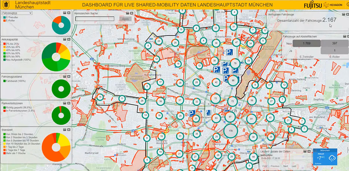
Tracking eScooters in Munich with Hexagon’s M.App Enterprise. (Image: Hexagon Geospatial)
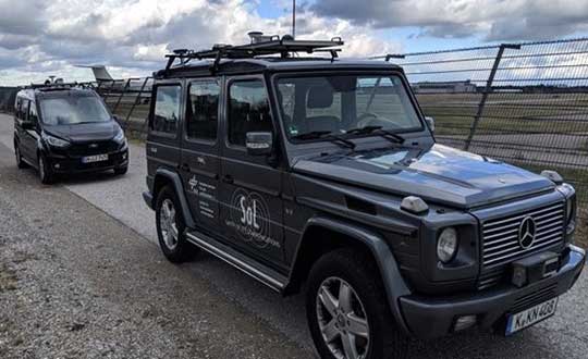
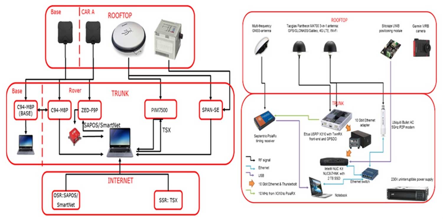
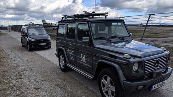
A pair of testbed vehicles went out on the road in Germany to simulate the way we are all likely to be using 5G positioning services in the future. The field test focused on assessing the performance of highly precise hybrid satellite/terrestrial positioning for autonomous vehicles, drones, smart cities and the internet of things (IoT).
The two vehicles were driven for a week around Munich and the surrounding area in a variety of environments, from the open-sky terrain surrounding the German Aerospace Center DLR’s site in Oberpfaffenhofen to the deep urban canyons of the city’s dense Maxverstadt district.
As they drove, they combined a broad range of on-board systems to measure their positions and share them with one another, performing ongoing vehicle-to-vehicle ranging to simulate future 5G operating standards.
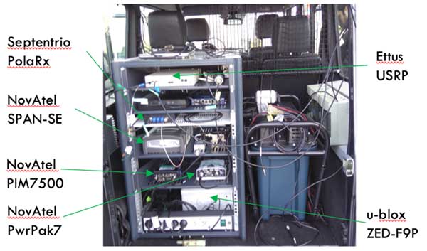
The on-board systems included multi-constellation satellite navigation (combining Europe’s Galileo, the U.S. GPS, Russian GLONASS and Chinese BeiDou), incorporating localized high-accuracy correction, and 4G Long-Term Evolution (LTE) and ultra-wideband (UWB) terrestrial wireless broadband communication.
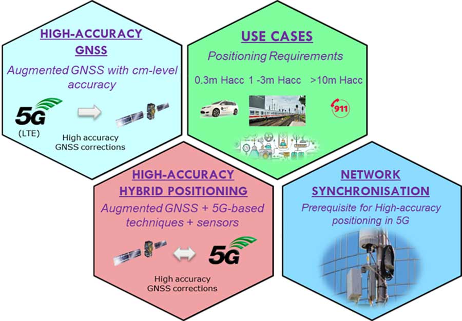
The coming of the next generation of mobile phone networks, 5G, promises much faster, more stable connectivity based on higher bandwidths and frequencies, but the ability to download a full movie in a matter of seconds is only the start. The increased capabilities will also open up a new range of services, many of them based around localization.
From smart traffic management to asset tracking to personalized drone-based delivery, our receivers’ ability to know where they are and share those positions with the wider network will be vital.
Close-up view of Car A with GNSS and LTE antennas. (Photo: ESA)
“The first step required is understanding what the upcoming disruptive applications are, and to identify the potential requirements associated with them,” said Riccardo de Gaudenzi, who leads ESA’s Electrical Department in its Directorate of Technology, Engineering and Quality.
“For these use cases, positioning and timing are key elements. Therefore positioning, navigation and timing (PNT) aspects, provided via GNSS like Galileo, the terrestrial communication infrastructure and hybridization of technologies, are extremely important.”
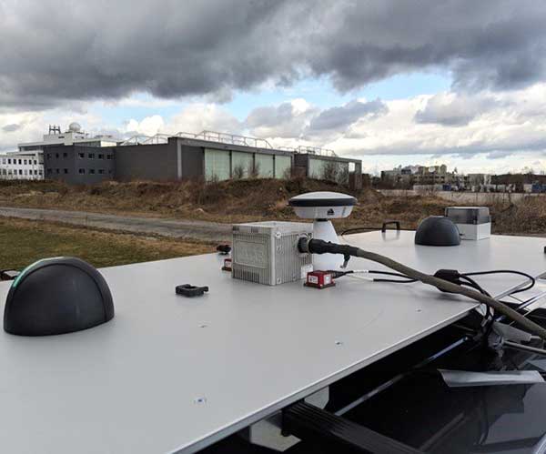
The testbed vehicles combined a broad range of on-board systems, including multi-constellation GNSS, incorporating localized high-accuracy correction. (Image: ESA)
Today we rely largely on satellite navigation to determine where we are. But our smartphones quietly blend satnav with other data sources to sharpen the accuracy of their results. That is why, for example, when you turn off your phone’s Wi-Fi receiver, your smartphone will warn you its mapping will become less accurate – it is also using Wi-Fi maps as a reference source.
With 5G, this trend of hybrid positioning will accelerate. Multiple GNSS constellation will be employed to increase accuracy, along with localized correction systems. In addition, the 5G cell network will provide additional corrections to enhance the GNSS localization accuracy and to complement GNSS when satellites are not visible.
This 5G “new radio” positioning accuracy will be enhanced by using steerable antennas on both the base station and the user terminal.
The testbed vehicles combined a broad range of on-board systems, incorporating localized high-accuracy correction and LTE 4G and ultra-wide-band terrestrial wireless broadband communication, to measure their positions and share them with one another and perform ongoing vehicle-to-vehicle ranging to simulate future 5G operating standards. (Image: ESA)
And because positioning performance will have to remain at the same high standard as user receivers move around — whether they be people, cars, shared bikes or drones — additional positioning solutions will also be employed, such as inertial sensors or device-to-device relative positioning.
Areas where ESA is contributing to 3GPP standardisation efforts. (Image: ESA)
Miguel Manteiga Bautista, head of ESA’s GNSS Evolution and Strategy Division in the Agency’s Directorate of Navigation, explains, “For the hybrid positioning field-tests, ESA and its partners set up a collaboration with Deutsche Telecom for use of its 4G network in Munich including relevant information for positioning, and NovAtel, who provided state-of-the-art GNSS equipment and correction services, such as the satellite-based TerraStar-X.”
ESA oversaw this initial field test campaign as part of its 5G GNSS Task Force, coordinated with the European Commission and the European GNSS Agency through the Horizon 2020 Framework Programme for Research and Innovation in Satellite Navigation.
The field test campaign was undertaken by DLR and the GMV company, with contributions by engineers from NovAtel, u-blox and Deutsche Telekom as well as ESA.
In 2016 the 5G GNSS Task Force within H2020 took the initiative to shape the support of high-accuracy positioning services in 4G and 5G networks, to contribute to the 3rd Generation Partnership Project, 3GPP, worldwide standardisation effort.
These field tests are executed within the GNSS Integration into 5G wireless networks or GINTO5G project. Undertaken through ESA’s European GNSS Evolution Programme, this project is being is executed by a consortium composed by GMV, Universitat Autonoma de Barcelona (UAB), DLR, u-blox and Telefonica I+D.
Currently, UAB is involved in the thorough processing of all the data gathered during the field test campaign, leading into models and simulation tools and possibly additional field experiments.
This pair of testbed vehicles went out on the road in Germany to simulate the way we are all likely to be using 5G positioning services in the future. (Photo: ESA)
The 2019 Munich Satellite Navigation Summit, which will take place March 25-27 in Munich, Germany, will offer a number of educational sessions to attendees.
One of the sessions will key in on the future use of the Galileo public regulated service (PRS). According to show organizers, this session will discuss the deployment of the Galileo ground- and space-segment — including the PRS relevant components — which will reach full operational capability in the next years. The session will also cover PRS-receiver developments and PRS testing.
Other sessions offered by the conference will include legal aspects on selected topics in the field of GNSS; augmented reality meets high-accuracy positioning; GNSS program updates; satellite and terrestrial navigation trends; and more.
According to organizers, the Summit is part of the efforts of the Bavarian government and the cluster on aerospace and satellite navigation to stimulate applications and services in this high-tech field.
Rohde & Schwarz and Huawei have successfully conducted cellular-based 5G V2X latency measurements in vehicular environments in field tests in Munich and Shanghai.
In a joint project between Huawei and Rohde & Schwarz, a precision end-to-end delay measurement system for over-the-air IP transmissions was applied to 5G V2X communication for cooperative driving applications in field tests in a moving car.
The precision absolute time standards on both ends were derived from two independent GPS receivers.
URLLC will enable automated driving. (Image: Rohde & Schwarz)
The initial measurements show that it is possible to achieve delays in the millisecond regime in a 5G network, demonstrating superior latency performance in comparison to LTE.
One of the key use cases of 5G is ultra-reliable low-latency communication (URLLC). Important for advanced vehicle-to-X communication use cases, URLLC will enable automated driving in the future.
A measurement accuracy below 2 µs for each transmitted IP packet was demonstrated. The transmitted data contained various IP traffic streams including video, lidar and control data (ITS messages) for a tele-operated vehicle.
While the trial in Munich was related to a tele-operated driving project, the tests in Shanghai were related to a platoon V2X testing site, where a number of vehicles traveling together are electronically connected via wireless communication.
The delay for transmission of one IP packet from source over-the-air to a (moving) receiver (sink) needs to be measured, spanning all delays introduced by the radio transmitter, propagation delay and radio receiver from/to IP packet level.
As latency is one of the key performance indicators of 5G and crucial for safety applications, such measurements could become an important criterion for future certification testing.
“We are delighted to collaborate with Huawei to contribute with our test and measurement expertise to 5G technology development,” said Andreas Pauly, executive vice president, Test & Measurement at Rohde & Schwarz. “With a strong global footprint in the telco ecosystem and close cooperation with partners, Rohde & Schwarz is committed to further expanding our innovative test and measurement solutions to new automotive applications.”