“Seen & Heard” is a monthly feature of GPS World magazine, traveling the world to capture interesting and unusual news stories involving the GNSS/PNT industry.
Bikes get tricked out
Image: Snik Bike
Snik Bike is a new app-paired tracking device designed to help users track their bikes if they are lost or stolen, reported North Shore News. Snik Bike Security Co-founder Fraser Vaage developed Snik Bike after having two of his bikes stolen. Snik equips any bike with a rechargeable location device that can be installed in five minutes or less. After pairing the device, the bike is automatically registered with Project 529, which is an online bike registration service. Vaage emphasized that while this device is not a ride-tracking software, such as Strava, it acts as an odometer, tracking overall mileage. The battery is only activated when a bike is stolen, Vaage said, therefore, it’s unlikely Snik will run out of battery. However, if it does, the device diverts to AirTag technology as a backup.
Lighthouses no more
Image: Wiltser/E+/Getty Images
With the wide adoption of GNSS, lighthouses on U.S. shorelines are no longer needed for navigation. To preserve these properties, the General Services Administration has been transferring ownership of the lighthouses to anyone willing to preserve them, reported The Guardian. This year, six lighthouses are being offered to federal, state or local government agencies, non-profits, educational organizations or anyone willing to make them publicly available for educational, cultural, or recreational purposes.
Location data ad weather resiliency
Image: DenisTangneyJr/E+/Getty Images
A Southern Methodist University research team, led by Nicos Markris, measured Dallas’ resilience by recording anonymous cell phone location data among residents in the Dallas metroplex before, during, and after the February 2021 North American winter storm. Measuring a city’s resilience is critical for planning responses to future events and uncovering potential vulnerabilities. By averaging location data, Makris and his team outlined the movement patterns of Dallas residents during a typical week. They compared the normal movement patterns to those during and after the week of the winter storm to determine when Dallas started getting back to normal.
GPS mitigates natural disasters
Image: Philip Thurston/E+/Getty Images
NASA’s Jet Propulsion Lab (JPL) is testing new ways to detect tsunami-like ocean waves before they cause catastrophic damage. The GNSS Upper Atmospheric Real-Time Disaster Information and Alert Network (GUARDIAN) is a new experimental monitoring system that can use data from clusters of GPS and other satellites to detect deadly waves triggered on Earth. Radio signals from GNSS are examined by scientific ground stations around the world. That data is then reviewed by the JPL’s Global Differential GPS network to help mitigate disasters. The GUARDIAN is still evolving and may be used in the future to develop early warning strategies, according to the United Nations’ International Committee on GNSS.
NASA-JPL prototype of POINTER base units on a first responder vehicle. The magneto-quasistatic fields they generate can be detected through walls, where legacy indoor positioning technologies fail. (Image: Jet Propulsion Laboratory)
A tragedy in 1999 spurred development of an entirely new type of positioning and location technology. “This project started with the Worchester, Massachusetts, warehouse fire,” said William Stout, program manager for the Department of Homeland Security (DHS) Science and Technology Directorate (S&T). “Six firefighters went in to clear an abandoned warehouse that was on fire to make sure there wasn’t anybody in there, and they got trapped. The team couldn’t find them because they had no idea where they were, and they ended up perishing.
That is what got DHS started with developing a first responder location tracking technology, Stout said.
“Over the years from that point on, we investigated many different technologies. My predecessor referred to most of these as ‘cocktail solutions’ because they would try to merge different types of technologies — for example, GPS and inertial — but none of these panned out.”
Enter Magnetoquasistatics Research
This lack of progress changed in 2012 when they connected with Darmindra Arumugam, group supervisor, senior research technologist and program manager at NASA’s Jet Propulsion Laboratory (JPL). Caltech manages JPL for NASA. In a complete departure from traditional radio signal-based positioning technologies, Arumugam and his team had been researching magnetoquasistatics (M/QS). This is the foundation for the POINTER System.
The system consists of fixed or portable transmitters, for instance, a base unit and controller that can be mounted on a first responder vehicle outside of a building. The first responders carry a small receiver that the base can locate with two characteristics: the field’s strength (for ranging) and its unique pattern (for lack of a better term) for direction (receivers send position info back to the controller via ISM band LoRa). The controller registers and displays the position of each receiver.
Why Magnetic Fields?
Ranging can be done in many modes, Arumugam said, and not all are based on just the amplitude of the propagating wave. With traditional radio signal ranging, to compute a precise position, techniques mostly use multiple sources of signals, for trilateration or multilateration, as GNSS does. However, signals can be perturbed by objects in their path, or experience multipath (signals bouncing off objects), which is a pronounced challenge for indoor environments.
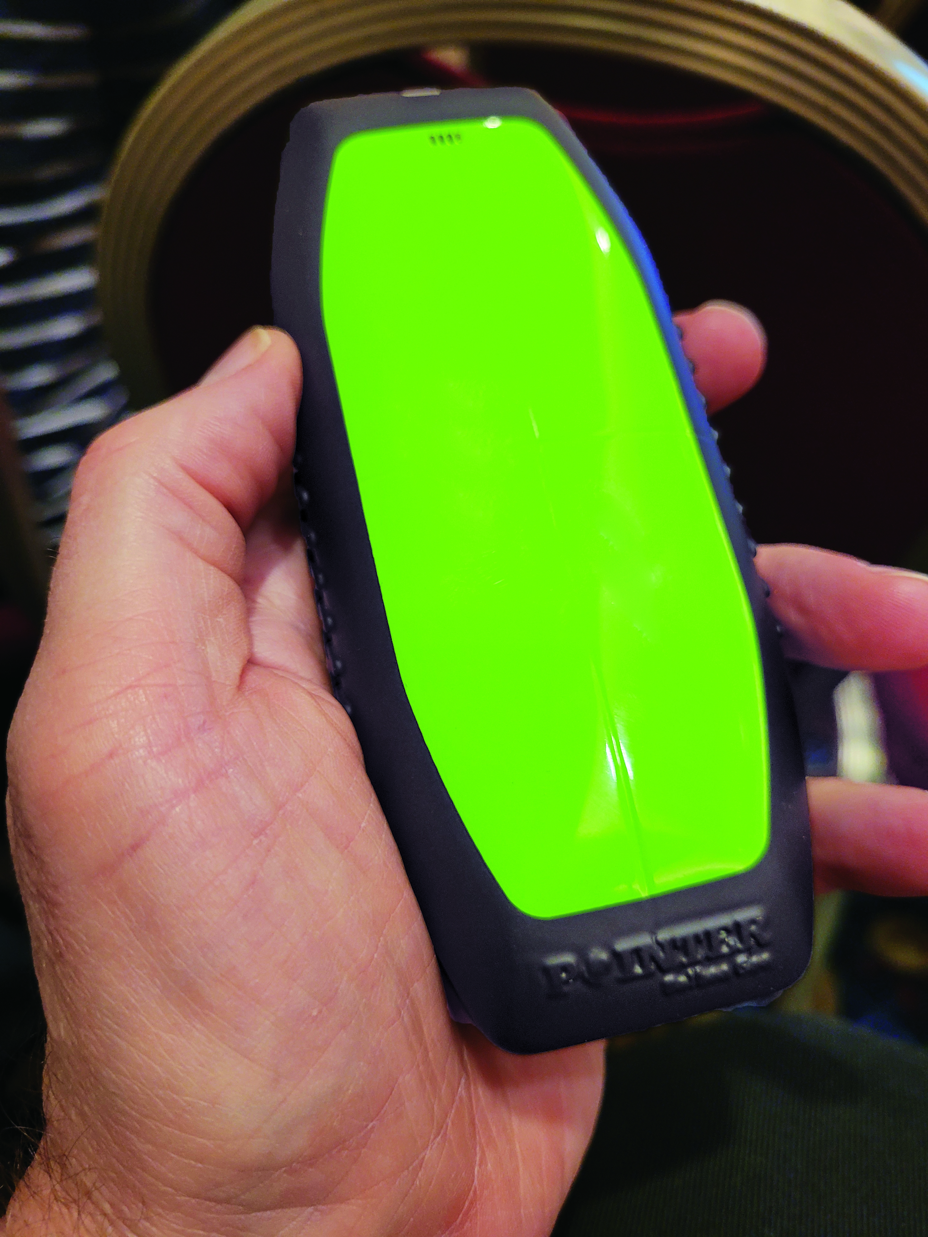
The portable POINTER receivers can be clipped by first responders to their belt, harness, or personal protective equipment, reporting their position in a building, and viewable by an incident commander on a laptop. (Image: Gavin Schrock)
POINTER does not employ radio signals in the fashion of traditional ranging solutions such as GNSS, ultra-wide band (UWB), and various beacon systems for indoor positioning. However, Arumugam said POINTER does generate a radio signal.
“The key difference is that we are detecting the field in a regime where there is no radio propagation mode. Therefore, it is more accurate to refer to this as a quasi-static field, as opposed to a radio propagating wave,” Arumugam said.
Arumugam said Earth’s magnetic field is a good example of this. “It penetrates structures very well, we can measure it 100 kilometers beneath the surface, far above the surface, inside buildings, underwater and so on,” he said. “POINTER uses the kind of the features that you see in Earth’s magnetic field — we are generating quasi-static magnetic fields.
“The term quasi-static highlights the fact that we are trying to keep the physics of the field stationary for all purposes but apply some slow time variation so that it’s really quasi-static to optimize the benefits from both,” Arumugam said. “We get the best of the behaviors of static fields in terms of penetration and non-line-of-sight capability, but also optimize for signal-to-noise by making this a quasi-static signal as opposed to a perfectly static one.”
JPL developed for DHS S&T prototypes that the two organizations tested jointly. Both transmitters and receivers employ an array of three coils, oriented at right angles for x, y and z. The resultant transmitted field carries distinct patterns from these three axes. Distance is detected from field strength, and direction is determined by detecting the pattern of the field relative to the three axes. A key strength of POINTER is that it can achieve ranging and direction from a single base station.
However, Arumugam noted that multiple bases could be beneficial for certain situations.
“The technique as originally developed requires only one transmitter. However, we find that there’s only so much you can get out of a magnetic field, and certain types of structures and materials will perturb that field, causing error.” The second transmitter is not only a backup, but it also helps reduce errors.
POINTER
Geolocation Inc. was spun out from Caltech to license and commercialize POINTER, said Joseph Boystack, executive chairman and co-founder. “We stepped in and executed an exclusive worldwide license for every field of use on this technology in late 2020 from JPL. They had established a proof of concept, and begun testing the technology in the field.”
For the initial commercial version, Balboa Geo made significant improvements over the JPL prototype system. It developed two transmitters that can be deployed on a fixed-mounted basis (buildings, vehicles, ships, etc.) or be portable housed inside a ruggedized, military specification (MIL-STD) case, with a built-in dual antenna GNSS receiver (to position and orient the transmitter).
“If you have an incident involving first responders, military or industrial applications, these remotely configured transmitters can be quickly and easily deployed,” Boystack said. “Also very important, because it only needs to depend on the field generated by the transmitter, we’re not dependent upon other large, fixed infrastructure such as satellites, towers or beacons, and can work in degraded environments where most other position, navigation and timing techniques fail.”
The self-contained receivers are only about the size of a smartphone. The orientation of the receiver is important to determine the “xyz” axis relative to the generated field, thus providing highly accurate three-dimensional position and navigation data. For instance, Balboa Geo’s receiver can be clipped to a first responder’s belt, harness, or personal protective equipment. Similarly, for fixed assets or moving assets such as warehouse systems or robotics, the orientation would be known.
The POINTER system will generate real-time data that can be easily visualized at the job site or event by the incident commander or manager on a laptop or a tablet. The data is interoperable and may be ingested in third-party software applications.
This version meets DHS STS’s original expectations, and subsequent versions will build on it. “S&T relies on experienced emergency response and preparedness professionals to guide our research and development. The First Responder Resource Group is made up of hundreds of state and local volunteers,” Stout said. “We initially looked at tracking firefighters in some of the most common scenarios: two-story house fires.”
While POINTER technology has the potential for much longer ranges and precisions, the current version, Arumugam said, certainly meets the specifications for this initial application. “The current systems can operate up to about 75 meters in range from the transmitter. So, if a transmitter is placed about 10 meters outside the building, say on the fire truck, you can penetrate up to about 65 meters inside the structure. That covers many one, two, maybe three-story structures. Position accuracies can be one meter or less. In principle, you could get to a centimeter, but that’s not required for this technology to be the lifesaver it presently needs to be.”
JPL continues research and development to extend range and increase precision to enable DHS S&T to deploy this technology to ever broader safety-of-life applications where legacy technologies fall short or are completely impractical. Balboa Geo is conducting field and lab tests for many more applications across multiple industries including energy, construction, maritime, mining, the internet of things and more.
I had my special ISO-certified glasses ready. Living in Oregon, I wasn’t about to miss the once-in-a-lifetime chance to see a total eclipse of the sun.
On Aug. 21, my family drove a few miles north to get into the path of totality, which for us lasted about a minute. It was definitely worth the field trip.
Besides regular folk like me, experts in numerous fields turned their eyes — and their instruments — to the eclipse.
The National Center for Atmospheric Research took to the air with a Gulfstream V fitted out with sensors and equipment for atmospheric research. The flight gathered data about the sun that can’t be collected from the ground.
With better instruments than ever before, for the first time scientists had the chance to observe the corona in the infrared spectrum, which may provide insight into the sun’s magnetic fields.
Back on terra firma, atmospheric scientists closely monitored changes in temperature and other weather effects. The temperature dropped as much as 7 degrees in Crossville, Tennessee, reports the National Weather Service.
Scientists at zoos and aquariums across the country closely watched animal behavior during totality. Species exhibiting unusual behavior included elephants, hippos, crocodiles and penguins.
The scientists found a “decrease in the number of free electrons in the part of the Earth’s ionosphere along the eclipse path where sunlight was temporarily blocked by the moon…
“TEC [total electron content] time series from two continuously operating GPS monitoring stations near the path of totality…show a small dip of about 2 TECU [TEC units] or so around 18:00 UTC on Aug. 21, coincident with the timing of the eclipse.”
The eclipse also affected WAAS real-time correction data from geostationary satellites.
While study of the data continues, it’s clear that GPS easily withstood the eclipse. Learn more here.