Tag: National Airspace System

  • Military drones advance as law enforcement seeks expanded counter-UAS mitigation authority

    Military drones advance as law enforcement seeks expanded counter-UAS mitigation authority

    General Atomics Aeronautical Systems Inc. (GA-ASI) is in the news again, as it got its prototype version of the U.S. Air Force (USAF) Collaborative Combat Aircraft (CCA) into the air for the first time, with an anticipated lengthy flight test campaign to follow. This latest CCA iteration, refered to as the YFQ-42A CCA, was derived from an earlier jet-powered XQ-67A Off-Board Sensing Station, a platform that enabled the company to not only develop and build but also fly this latest aircraft in just one year.

    GA-ASI CAA makes first flight Aug.t 27, 2025. (Credit: GA-ASI)
    GA-ASI CAA makes first flight Aug. 27, 2025. (Credit: GA-ASI)

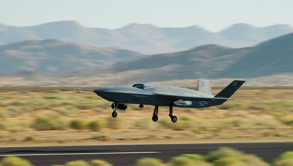
    The UAV features significant autonomous capabilities developed over nearly five years of training using the MQ-20 Avenger unmanned jet aircraft. The strategy of beginning with a company-developed baseline aircraft (Avenger), securing USAF support for an initial derivative and then for the YFQ-42A CCA, appears to be accelerating development of the Loyal Wingman concept toward USAF operational manned-unmanned airborne teaming.

    Previously, in July, GA-ASI began preparations to enable friendly European countries to rapidly participate in the future CCA-capabilites by teaming with its German affiliate General Atomics Aerotec Systems GmbH (GA-ATS). The agreement appears to enable high-volume local manufacture of a European CCA, and press releases have implied that potential content is expected to be provided by other high-tech local suppliers.


    Following earlier reports that Reliable Robotics (RR) has been busy automating all phases of aircraft operations, including a Cessna Caravan cargo aircraft, USAF has awarded RR a $17.4 million contract to install a Reliable Autonomy System (RAS) in another Cessna. The resulting automated Cessna 208A Caravan is to be used in an estimated two-year program toward obtaining FAA certification that should enable flight within the U.S. National Airspace System (NAS). The system has been demonstrated — with a remote pilot in the loop — to be able to take an aircraft from startup on the ramp, through taxi, takeoff, en route flight, landing and taxi return to the ramp for unloading.

    RR autonomous Cessna 208B takes off from Mojave Air and Space Port, California, on Aug. 8, 2024. (Credit: RR))
    RR autonomous Cessna 208B takes off from Mojave Air and Space Port, California, on Aug. 8, 2024. (Credit: RR)

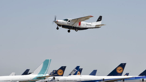
    Cessna Caravans have been heavily used for cargo transport across the U.S. (and around the world) with a range of 1000 miles, carrying up to 1000 lb of cargo. The RR certification program is intended to allow these types of automated unmanned commercial and military operations on a regular basis throughout FAA controlled US airspace, alongside manned aircraft. Flying military unmanned aircraft in the NAS currently requires extremely highly-coordinated, continuous activity. The hope is that eventually it could become an easier more regular form of autonomous cargo/people air transport.


    The cost of the continuing war in Ukraine may be affecting the Russian economy — a major drone manufacturer apparently is facing bankruptcy despite Russia currently using thousands of drones in attacks on Ukraine. The situation is difficult to understand, but this is an expensive war.

    However it appears that, AO Kronshtadt, one of the major drone suppliers in Russia is also beset by civil lawsuits from several organizations to which it owes lots of rubles. Its Orion and an updated version Inokhodets drone are apparently somewhat similar to the US MQ-9 Reaper UAV.

    AO Kronstadt employees assemble the Russian Orion UAV. (Credit: open source)
    AO Kronstadt employees assemble the Russian Orion UAV. (Credit: open source)

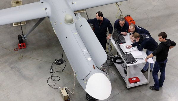
    Russia has apparently converted the Orion/Inkhodets medium-altitude surveillance drone into a strike version, but with limited success. Nevertheless, Kronshtadt apparently has made some progress, selling an export version in Asia.

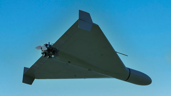
    Meanwhile, Russia still is apparently producing up to 6,000 Shahed one-way drones per month by another manufacturer in the Alabuga Special Economic Zone at a unit cost of around $70,000. This is significantly lower than drones that were originally purchased from Iran at $370,000 each.

    Shahed suicide drone. (Credit: Olena Bartienieva / iStock / Getty Images Plus / Getty Images
    Shahed suicide drone. (Credit: Olena Bartienieva / iStock / Getty Images Plus / Getty Images)

    The U.S. Federal Government through its transport agencies apparently has the exclusive right to control drones, including bringing malicious UAVs down from the sky. Most people understand that the Federal Aviation Administration (FAA) regulates who flies what and where, but who is in charge of reducing and removing drone threats? It may have been difficult to understand during recent unauthorized overflights of military installations on the East Coast why someone didn’t shoot down the offending drones.

    Now, a group of police agencies has approached members of Congress to ask for the right to “detect, track, identify and mitigate” the unlawful, negligent or malicious use of drones that threaten public safety. Citing a number of incidents — including drone incursions at airports and other incidents where unmanned aircraft have interfered with firefighting and disaster response, instances where law enforcement activities have been overflown and disrupted, and the practice of using drones to drop drugs, guns and mobile phones into prisons — the law enforcement group sees a need for permission to engage. With several major events scheduled across the U.S., it likely is time to support law enforcement with the appropriate powers needed to protect the public.

    It is true that several bills are already pending before Congress to enable state, local, tribal and territorial law enforcement agencies to find, identify and possibly mitigate inappropriate drone activity, but the group is urging action now. And they clearly demonstrate the need to be able to stop drone activity when necessary — the federal government cannot cover the whole country all the time, so it makes more sense to adequately train law enforcement and to distribute authorized local mitigation activity whenever it is found to be necessary.


    So a mixed bag this month — progress for the U.S. Collaborative Combat Aircraft initiative, more steps toward automation for air cargo transport, problems for one Russian drone supplier while others increase volume and the United States seeks options for better defense against them, and U.S. law enforcement seeks the capability to help mitigate drone incursions where they are not wanted — plenty of different angles to consider around unmanned aerial vehicles.

  • XPONENTIAL 2023: Final thoughts

    XPONENTIAL 2023: Final thoughts

    AUVSI XPONENTIAL 2023 has officially concluded. GPS World had the opportunity to visit several booths during the conference and attend a variety of educational sessions while in the heart of beautiful, downtown Denver.

    See below for some takeaways from XPONENTIAL.

    "Protecting the Homeland: The future of C-UAS” was presented by industry leaders and highlighted capabilities available for detecting, intercepting, and mitigating UAS encroaching or threatening covered facilities, critical infrastructure, and other high-value targets in the National Airspace System.
    “Protecting the Homeland: The future of C-UAS” was presented by industry leaders and highlighted capabilities available for detecting, intercepting, and mitigating UAS encroaching or threatening covered facilities, critical infrastructure, and other high-value targets in the National Airspace System.

    GPS World stopped by infiniDome to hear more about its solutions, including GPSdome.
    GPS World stopped by infiniDome to hear more about its solutions, including GPSdome.

    Harxon had its new helix antenna series on display at its XPONENTIAL booth.
    Harxon had its new helix antenna series on display at its XPONENTIAL booth.

    “Autonomous Exploration and Mapping of Unknown Environments with UAS” dove into the development of simultaneous localization and mapping, world modeling and exploration-based planning algorithms. This session was led by Eric Thorn, manager in the Intelligent Systems Division at Southwest Research Institute.
    “Autonomous Exploration and Mapping of Unknown Environments with UAS” dove into the development of simultaneous localization and mapping, world modeling and exploration-based planning algorithms. This session was led by Eric Thorn, manager in the Intelligent Systems Division at Southwest Research Institute.

    Honeywell shared the ground station that it is developing.
    Honeywell shared the ground station that it is developing.

    While CGConnect has already been launched overseas by Advanced Navigation, its first debut in the United States was at XPONENTIAL.
    While CGConnect has already been launched overseas by Advanced Navigation, its first debut in the United States was at XPONENTIAL.

  • FAA awards $4.4 million in drone research grants to 7 universities

    FAA awards $4.4 million in drone research grants to 7 universities

    Photo: PhonlamaiPhoto/iStock / Getty Images Plus/Getty Images
    Photo: PhonlamaiPhoto/iStock / Getty Images Plus/Getty Images

    The U.S. Department of Transportation’s Federal Aviation Administration (FAA) has announced $4.4 million in drone research, education and training grants to seven universities.

    Research will focus on three areas:

    • electromagnetic compatibility
    • detect-and-avoid classifications
    • cybersecurity oversight.

    “This funding and our ongoing partnerships with these universities will allow the FAA to safely integrate the airspace that has a growing number of diverse aircraft users,” said FAA Acting Administrator Billy Nolen.

    The research initiatives and grant awardees include:

    Evaluate Unmanned Aircraft Systems (UAS) Electromagnetic Compatibility

    This research will assess the risks, identify drone design vulnerabilities, identify material and procedural mitigations, and propose guidance for safer electromagnetic compatibility with emitted and static fields.

    • University of North Dakota, $325,042
    • University of Kansas, $325,000
    • Drexel University, $325,830

    Investigate Detect-and-Avoid Track Classification and Filtering

    This research will provide proposed metrics, guidance and test methods to assess the effects of false or misleading information on detect-and-avoid capabilities. The findings will support beyond-visual-line-of-sight operations.

    • The Ohio State University, $732,441
    • Embry-Riddle Aeronautical University, $371,000
    • Mississippi State University, $330,000
    • University of North Dakota, $80,000

    Illustrate the Need for UAS Cybersecurity Oversight and Risk Management

    This research will address UAS cybersecurity oversight and risk management as it pertains to the National Airspace System and other FAA systems.

    • University of Kansas, $651,982
    • Oregon State University, $609,226
    • Drexel University, $608,783

    Today’s announcement is the second round of Alliance for System Safety of UAS through Research Excellence (ASSURE) grants, which brings the total of 15 grants valued at $18.3 million for Fiscal Year 2022.

    The ASSURE Center of Excellence is one of six that the FAA has established to help advance technology and educate the next generation of aviation professionals. Research conducted through ASSURE is focused on helping the drone market safely grow and integrate into the nation’s airspace.

    More than 800,000 recreational and commercial drones are in the active drone fleet, and that number is expected to grow.

  • Integrity flies on Mars, while ‘certifiable’ drone level sought in the United States

    Integrity flies on Mars, while ‘certifiable’ drone level sought in the United States

    This month, the four-pound Integrity dual-rotor UAV on Mars continues to fly and may be moving into a scouting role. Plus, there are continuing efforts to move UAV electronics towards a “certifiable” level to support integration in regular airspace. Finally, a newly launched parcel delivery drone has increased carrying capacity.

    The excitement around flying an unmanned helicopter on Mars is gradually dissipating as Ingenuity racks up more flights and the NASA team prepares for an elongated flight schedule following the initial 30-day flying experiment. Data from the Martian UAV passes back and forth through the Perseverance rover, which now has things of its own to do and places to go. An initial 30-foot crawl a couple of days ago signaled the beginning of the rover’s ground activities, which are the main focus of the mission.

    However, the little UAV has achieved plenty and appears to have lots of life left to fly. We’re now up to five flights, with the latest taking Ingenuity more than 420 feet, flying at a height of 15 feet to a new landing spot, ahead of where the rover intends to travel.

    Before landing, NASA took the UAV up to 33 feet, where future flights should be able to better view features for the rover to investigate. Integrity’s role may now transition to scouting an advance path for rover exploration — one of the principle objectives for the little UAV.

    A tiny speck in the distance, NASA Ingenuity UAV flies on Mars looking for a new landing spot during its fourth flight. (Photo: NASA)
    A tiny speck in the distance, NASA’s Ingenuity UAV flies on Mars looking for a new landing spot during its fourth flight. (Photo: NASA)

    NASA is planning a few additional trips for Integrity in the next week or so — adequate power is being captured by the top-mounted solar cell to fly and keep the vehicle warm through the cold Mars nights, and the miniaturized avionics systems are holding up well. Hopefully, we will still hear of new accomplishments in weeks to come. Incidentally, Perseverance can now capture the sound of the UAV’s spinning blades and the background wind on the surface of Mars.

    FAA certification for drones

    News here on Earth is about much more capable unmanned vehicles, new innovations and new applications, and efforts seem to be gaining ground toward certifying UAS and their systems to recognized Federal Aviation Administration (FAA) standards, so integration into the National Airspace System (NAS) might roll out sooner than expected.

    When a manufacturer produces an electronic component and qualifies it to the necessary FAA standards, it does not automatically make it a certified product. It only becomes certified on a particular model of aircraft or UAV when the vehicle is certified for operational use by the FAA. There are similar standards and certification requirements in Europe and around the rest of the world.

    Enter George

    Photo: uAvionix
    Photo: uAvionix

    uAvionics in Leesburg, Virginia, recently launched a new certifiable UAS autopilot — with the cute name of “George.” As older aviation enthusiasts might recall, this moniker was what the World War II pilots of long-range piston engine bombers sometimes called their rudimentary autopilots, which held wings level on long-endurance flights.

    With triplex gyros and accelerometers, dual processors and compasses, and a barometer, the unit is lightweight and low power, but has been developed to all the principal aviation requirements, including software and environmental standards.

    George joins uAvionics’ line of other aviation qualified/certifiable hardware for UAVs. This includes the ping200X ADS-B for beyond-visual-line-of-sight (BVLOS) detect and avoid, and the trueFYX TSO-C145e certified GPS receiver.

    Seeking Certification

    Sagetech in White Salmon, Washington, is another supplier working hard toward certifiable equipment for unmanned aircraft. Sagetech’s detect-and-avoid (DAA) solution makes use of its ADS-B transponder, which can be paired with other airborne collision avoidance system (ACAS) components.

    Sagetech offers a design engineering service to enable UAV operators and manufacturers to come up with a certifiable solution while FAA standards are still being developed.

    Sagetech ADS-B certifiable transponder/Mode-S interrogator. (Photo: Sagetech)
    Sagetech ADS-B certifiable transponder/Mode-S interrogator. (Photo: Sagetech)

    Embention in Alicante, Spain, also advertises several certifiable autopilots, power and control components for unmanned aircraft. It manufactures a variety of Nmand-branded UAVs along with multi-rotor UAV solutions, including a drone recharging station.

    Three times the cargo

    Meanwhile, drone-delivery capability continues to advance with the recent introduction of the certifiable Wingcopter 198.

    The Wingcopter 198 drop-winch cargo drone. (Photo: Wingcopter)
    The Wingcopter 198 drop-winch cargo drone. (Photo: Wingcopter)

    The vertical-take-off-and-landing (VTOL) delivery drone has a triple-drop winch mechanism that allows for delivery of up to three packages per flight. The UAV takes off and lands vertically, thanks to its tilt-rotor design, and can carry a payload of up to 13 pounds. It can travel up to 47 miles on one electrical charge at up to 93 mph; with fewer packages, a range of up to 68 miles may be possible.

    The VTOL UAV has redundant design elements that position it to support FAA certification. It has eight redundant motors. Also, the autopilot, airspeed sensor and battery are dual redundant. Consequently, the Wingcopter 198 is undergoing FAA-type certification in the United States.

    The Wingcopter 198 also has artificially aided downward-looking cameras to support management of parcel delivery, as well as obstacle avoidance and landing.

    To sum up, life may not yet be over for the Integrity UAV on Mars as it moves into a route-scouting role for the rover. There is more progress toward certifiable configurations of equipment to support unmanned integration into the NAS. Finally, last-mile parcel deliveries could benefit from higher capacity certified drone carriers.

    Tony Murfin
    GNSS Aerospace

  • FAA restricts drones over more DOJ and DOD facilities

    The Federal Aviation Administration (FAA) has issued additional drone flight restrictions over U.S. federal prisons, military bases and Pearl Harbor, effective Feb. 26.

    At the request of its federal security partners, the FAA is using its existing authority under Title 14 of the Code of Federal Regulations (14 CFR) § 99.7 — “Special Security Instructions” — to address concerns about drone operations over national security sensitive facilities by establishing temporary unmanned aircraft system (UAS) specific flight restrictions.

    This is in addition to previous restrictions over prisons, NGA facilities, DoD ships and other facilities.

    Information on the FAA Notice to Airmen (NOTAM), which defines these restrictions, and all of the currently covered locations, can be found at the FAA’s UAS Data Display System, which provides an interactive map, downloadable geospatial data, and other important details.

    A link to the restrictions is also included in the FAA’s B4UFLY mobile app.

    Additional, broader information regarding flying drones in the National Airspace System, including frequently asked questions, is available on the FAA’s UAS website.

    In cooperation with Department of Justice (DOJ) and Department of Defense (DOD), the FAA is establishing additional restrictions on drone flights up to 400 feet within the lateral boundaries of the following federal facilities:

    Federal Correctional Institution Allenwood Medium in Allenwood, PA
    Federal Correctional Institution Beaumont Medium in Beaumont, TX
    Federal Correctional Institution Butner Medium I in Butner, NC
    Federal Correctional Institution Butner Medium II in Butner, NC
    Federal Correctional Institution Coleman Medium near Sumterville, FL
    Federal Correctional Institution Florence in Florence, CO
    Federal Correctional Institution Forrest City Medium in Forrest City, AR
    Federal Correctional Institution Hazelton near Bruceton Mills, WV
    Federal Correctional Institution Lompoc in Lompoc, CA
    Federal Correctional Institution Oakdale I in Oakdale, LA
    Federal Correctional Institution Oakdale II in Oakdale, LA
    Federal Correctional Institution Petersburg near Hopewell, VA
    Federal Correctional Institution Pollock in Pollock, LA
    Federal Correctional Institution Terre Haute in Terre Haute, IN
    Federal Correctional Institution Tucson in Tucson, AZ
    Federal Correctional Institution Victorville Medium I in Victorville, CA
    Federal Correctional Institution Victorville Medium II in Victorville, CA
    Federal Correctional Institution Yazoo City Medium in Yazoo City, MS
    Federal Detention Center Honolulu in Honolulu, HI
    Federal Detention Center Houston in Houston, TX
    Federal Detention Center Miami in Miami, FL
    Federal Detention Center Philadelphia in Philadelphia, PA
    Federal Detention Center SeaTac near Seattle, WA
    Federal Medical Center Carswell near Fort Worth, TX
    Federal Medical Center Fort Worth in Fort Worth, TX
    Federal Medical Center Rochester in Rochester, MN
    Metropolitan Correctional Center Chicago in Chicago, IL
    Metropolitan Correctional Center New York in New York City, NY
    Metropolitan Correctional Center San Diego in San Diego, CA
    Medical Center for Federal Prisoners Springfield in Springfield, MO
    Metropolitan Detention Center Brooklyn in Brooklyn, NY
    Metropolitan Detention Center Guaynabo in Guaynabo, PR
    Metropolitan Detention Center Los Angeles in Los Angeles, CA
    Fort Detrick in Frederick, MD
    Fort Gordon near Augusta, GA
    Fort Lee near Richmond, VA
    Holston Army Ammunition Plant near Kingsport, TN
    McAlester Army Ammunition Plant in McAlester, OK
    Radford Army Ammunition Plant in Radford, VA
    Joint Base McGuire near Trenton, NJ
    Pearl Harbor Naval Defense Sea Area in Honolulu, HI

    These changes, which have been highlighted by FAA NOTAM FDC [9/2586], are pending until they become effective on Feb. 26. Note that there are only a few exceptions that permit drone flights within these restrictions, and they must be coordinated with the individual facility or the FAA.

    Operators who violate the flight restrictions may be subject to enforcement action, including potential civil penalties and criminal charges.

    The FAA is continuing to consider additional requests by eligible federal security agencies for UAS-specific flight restrictions using the agency’s § 99.7 authority as they are received. Additional changes to these restrictions will be announced by the FAA as appropriate.

  • FAA program advances drone integration in National Airspace System

    FAA program advances drone integration in National Airspace System

    This report covers a number of UAV topics, including the news of another U.S. Federal Aviation Administration (FAA) program to advance drone integration in the U.S. National Airspace System (NAS); an initial effort towards Type Certification for a larger UAV/UAS; cautious steps to protect U.S. Navy and Coast Guard ships from unwanted drone overflight; and what would appear to be a surge in the number of acquisitions across the industry.

    FAA Integration Pilot Program

    There are signs of growing momentum to get UAVs flying in the U.S. NAS. The FAA Integration Pilot Program (IPP) website indicates that this latest initiative is spread across a number of different applications, locations and supporting organizations. The FAA cites the following objectives for IPP:

    • Connecting local and national UAS integration interests
    • Improving local, state and tribal communications
    • Addressing security and privacy risks
    • Speeding up special authorizations.

    So it’s perhaps more about getting organizations at the local level into the picture, and fostering cooperation with national interests. But, at the same time, pilot projects will feed knowledge into the hopper of how to get UAVs into the U.S. NAS.

    Operational concepts to be investigated include night operations, flights over people, flights beyond visual line of sight, package delivery trails, testing detect-and-avoid technologies and verifying the reliability and security of UAS data links.

    Certification Program underway for Insitu ScanEagle3

    Along the same lines, Insitu is working with FAA staff towards certification of the commercial ScanEagle3 drone system to enable flights in U.S. controlled airspace. A recent three-day Type Certification Board meeting held between FAA and Insitu included launch-to-capture flight tests, plus review of applicable standards, flight training and technical publications and manuals to determine Insitu’s basis for the proposed UAS Type Certification of the ScanEagle3 in 2019.

    Once an aircraft or UAS gains Type Certification, it should be possible to fly that model on a regular basis, without the need for special FAA authorization of individual operations, as is currently the requirement for drones — other than for small UAS (sUAS), which already have FAA approved operational regulations. This effort could also clear the way for certification of larger drones to regularly operate in the NAS. Filing a flight plan with local FAA controllers prior to each flight would then typically be required, as is standard for all manned aircraft.

    FAA review teams examine Insitu’s ScanEagle3 at a type certification board meeting in Bingen, Washington (Photo: Insitu)
    FAA review teams examine Insitu’s ScanEagle3 at a type certification board meeting in Bingen, Washington (Photo: Insitu)

    At the recent review meeting with FAA team members from various certification groups, Insitu discussed its internal culture of safety, which is in line with the FAA’s extremely strict safety standards. The design and technology of ScanEagle3 was demonstrated, and the maturity of Insitu as an aircraft manufacturer was emphasized.

    The FAA teams participated in an overview of Insitu’s Project Plan for Certification, examining Insitu’s detect-and-avoid (DAA) capability planning, safety management system and model-based engineering processes.

    Insitu is hopeful that Type Certification will enable ScanEagle3 to be applied quickly to all types of operation, which could include data collection, analysis and delivery; aerial infrastructure survey; disaster recovery; and wildfire suppression – without the delay currently associated with seeking permits and overcoming temporary flight restrictions.

    FAA restricts drone operations near sensitive U.S. facilities

    Meanwhile, the FAA flexed its legal muscles to restrict drone flights near U.S. Navy (USN), U.S. Coast Guard (USCG) and Department of Energy (DoE) facilities and assets. Growing concerns with potential malicious drone flights over sensitive, high-priority facilities and ships apparently prompted the FAA to issue two NOTAMs (Notice to Airmen). The first notification describes the locations and the assets – in this case, ships operating from two bases — and includes the form of restrictions that are being applied.

    Drone flights have been restricted around USN and USCG vessels operating near Naval Base Kitsap in Washington state and Naval Submarine Base Kings Bay in Georgia. Drones are not allowed to get closer than 3,000 feet laterally and 1,000 feet vertically from vessels. And the NOTAMs carry the dire warning that these ships have the authorization and ability to take whatever action they feel necessary to protect themselves from such threats.

    In other words, if the nut-case flying an unwelcome drone penetrates the restricted area around a Navy or Coast Guard ship, the target ship might well take out the unwanted drone. And the FAA may also pursue civil penalties and/or criminal charges against the operator for disobeying the restrictive notice.

    The second NOTAM warns drone flyers to remain clear of all national Department of Defense (DoD) and DoE facilities and mobile assets, as well as USCG vessels. With UAVs carrying explosive devices becoming more common in areas of conflict or political unrest (in Venezuela, for instance), it’s not surprising that U.S. DoD is concerned this could soon start to happen closer to home.

    Industry consolidation continues

    Finally, following a letter of intent from Textron Systems to buy Howe & Howe Technologies a land mobile robotics defense outfit, drone industry consolidation also seems to be gaining momentum.

    Howe & Howe’s land vehicles are built and proven for extreme environmental conditions, and U.S. government customers have selected Howe & Howe’s small, highly mobile Ripsaw Super Tank for its speed, mobility and off-road performance, while the RS2-H1 SMET was down-selected to compete to be the U.S. Army’s first platoon load-carrying robot, after completing a 60-mile test through swamp and jungle terrains.

    Textron Systems continues to position itself as a global leader in autonomy applications in air, land and sea.

    In addition, Delair has just announced an agreement to acquire the key assets of Airware — a developer of software analytics tools for data collected by drones. The acquisition quickens Delair’s growth and increases options for the commercial UAV market. Delair provides end-to-end solutions, including fixed-wing drones, cloud-based data processing and analysis, local customer support and custom consulting services.

    Delair UX11 mapping drone (Photo: Delair)
    Delair UX11 mapping drone (Photo: Delair)

    The acquisition is through an asset purchase of Airware’s technology, including proven software, related personnel in Paris, existing customer relations and established distribution channels. Airware’s data management and data analysis tools will be highly complementary with Delair’s existing solutions and will also expand Delair’s U.S. market presence, providing access to additional key industrial markets.

    Airware, based in California, has provided a cloud-based software solution to large companies in the construction, mining and insurance industries. Its software solution was developed with support from Caterpillar and has been distributed by Caterpillar dealers to more than 50 countries to improve the productivity and safety in mines, quarries and construction sites.

    Delair, with more than 180 employees worldwide, has customers in a number of industries including mining, construction, energy, utilities, oil and gas, transportation and security.

    PrecisionHawk has also announced the purchase of Uplift Data Partners, which provides turnkey inspection services for construction, building information management (BIM) and real-estate. This is PrecisionHawk’s fifth acquisition during 2018 — earlier acquisitions have included Droners.io, Airvid, HAZON and InspecTools. These acquisitions have created dynamic synergy, and provided enhanced airborne intelligence with strengthened data value for PrecisionHawk.

    Uplift’s commercially trained drone pilots will join PrecisionHawk’s network of more than 15,000 drone pilots, one of the largest networks of its kind. Suzanne El-Moursi, CEO of Uplift, will join PrecisionHawk’s executive team and will manage the company’s construction business.

    The intent is for customers to receive best-in-class aerial data and analytics for complex construction and facility inspection projects, through combined PrecisionHawk’s advanced products and services, and Uplift’s industry experience and training standards.

    PrecisionHawk and Uplink will combine products for construction projects. (Photo: PrecisionHawk)
    PrecisionHawk and Uplink will combine products for construction projects. (Photo: PrecisionHawk)

    Uplift Data Partners has been an integrated subsidiary of Clayco, an architecture, engineering, design-build and construction firm, with more than $2 billion in annual revenue. Following the spin-off, Clayco will still source its construction projects exclusively to PrecisionHawk, and will support PrecisionHawk’s board of advisors.

    The construction industry has rapidly adopted commercial drone technology — transforming construction processes by decreasing the need for protracted visual inspections, shortening planning time, improving worker safety and quickly identifying problems.

    And finally — Microdrones, a provider of professional UAV solutions, has announced that it has acquired geomatics service provider Navmatica Middle East (ME) with an office and team in Dubai, UAE. Navmatica ME supplies services and custom software development for geodetic positioning, airborne mapping, mobile mapping and indoor mapping.

    Microdrones md4-3000 drone (Photo: Microdrones)
    Microdrones md4-3000 drone. (Photo: Microdrones)

    The acquisition establishes a foothold in the Middle East market for commercial drones, and adds an experienced team of geomatics engineering specialists, software developers and systems engineers who have a proven track record of providing customers with high-quality geomatics services and technology.

    Summary

    We have FAA efforts to move further forward with UAV integration with its IPP program, first steps down the lengthy and somewhat arduous path towards the certification of larger UAVs to enable less restrictive flight in the U.S. NAS, notifications to operators to improve protection of Navy and Coast Guard ships from unwanted overflight and potential drone attack, and plenty of signs of drone service and manufacturer business consolidation — lots of what we may think of as positive indications of greater maturity and progress for the UAV industry.

  • More outreach needed before interference events, FAA told

    More outreach needed before interference events, FAA told

    U.S. Department of Defense interference events, designed for training in GPS-denied environments, also can affect civilian aircraft.

    In April 2016, a business jet lost all GPS signals because of an interference event and was forced to enter a Dutch Roll, resulting in an emergency descent.

    Pilots and air traffic controllers in the National Airspace System want to better understand the operational impacts of the intentional interference, which has risen from 43 in 2012 to 127 in 2017.

    Interference Contours from the YPG 17-02 GPS interference event in January 2017. (Source: FAA)
    Interference Contours from the YPG 17-02 GPS interference event in January 2017. (Source: FAA)

    An RTCA Tactical Operations Committee composed of Federal Aviation Administration (FAA) and industry experts in March issued a report with recommendations to change the current Notices to Airmen (NOTAMs).

    Along with a description of the event, NOTAMs show contours that represent an area outside of which operators should expect no interference impact. Both operators and the FAA agree that most aircraft experience no interference impact even inside the contours.

    Operators recommend that the FAA provide pilots and controllers improved understanding of where to expect interference impacts based on different equipment capabilities, so that operators could integrate such information in their flight planning processes.

    Impact varies widely, depending on aircraft, avionics, position, time, location and terrain. Effects could include complete loss of GPS navigation, position errors, loss of ADS-B or impact to GPS-dependent systems.

    Operators are encouraging thte FAA to conduct outreach with civil aviation stakeholders around significant interference events so they better understand the impact.

    The FAA says it is studying the committee’s 25 recommendations.

  • FAA restricts drones over federal prisons, Coast Guard bases

    The Federal Aviation Administration (FAA) has established temporary unmanned aircraft system (UAS) flight restrictions over federal penitentiaries and U.S. Coast Guard bases.

    The restrictions, which take place June 20, are for drone flights up to 400 feet within the lateral boundaries of the facilities.

    The restrictions came at the request of federal security partners the Department of Justice (DOJ) and Department of Homeland Security (DHS).

    The FAA is using its existing authority under Title 14 of the Code of Federal Regulations (14 CFR) § 99.7 — “Special Security Instructions” — to address concerns about drone operations over these facilities,” the agency stated.

    Information on the FAA Notice to Airmen (NOTAM), which defines these restrictions, and the covered locations, can be found on the FAA’s UAS website. Broader information regarding flying drones in the National Airspace System, including frequently asked questions, is also on the FAA website.

    An interactive map, downloadable geospatial data and other important details can be found here.

    A link to the restrictions is also included in the FAA’s B4UFLY mobile app.

    This is the first time the FAA has placed specific flight restrictions for unmanned aircraft over Federal Bureau of Prisons and Coast Guard facilities. The FAA has placed similar flight restrictions over military installations that remain in place, as well as over 10 Department of Interior facilities and seven Department of Energy facilities.

    Operators who violate the flight restrictions may be subject to enforcement action, including potential civil penalties and criminal charges.

    There are a few exceptions that permit drone flights, which must be coordinated with the individual facility or the FAA.

    The FAA is considering additional requests by eligible federal security agencies for UAS-specific flight restrictions using the agency’s §99.7 authority as they are received. Additional changes to these restrictions will be announced by the FAA as appropriate.

    The following facilities will have the new restrictions:

    United States Penitentiaries (USP)

    USP Tucson near Tucson, AZ
    USP Atwater near Atwater, CA
    USP Victorville near Victorville, CA
    USP Florence High near Florence, CO
    USP Florence ADMAX near Florence, CO
    USP Coleman I near Sumterville, FL
    USP Coleman II near Sumterville, FL
    USP Marion near Marion, IL
    USP Terre Haute near Terre Haute, IN
    USP Big Sandy near Inez, KY
    USP McCreary near Pine Knot, KY
    USP Pollock near Pollock, LA
    USP Yazoo City near Yazoo City, MS
    USP Allenwood near Allenwood, PA
    USP Canaan near Waymart, PA
    USP Lewisburg near Lewisburg, PA
    USP Beaumont near Beaumont, TX
    USP Lee near Pennington Gap, VA
    USP Hazelton near Bruceton Mills, WV

    United States Coast Guard (USCG) Bases

    USCG Baltimore Yard, MD
    USCG Base Boston, MA
    USCG Base Alameda, CA
    USCG Base Los Angeles/Long Beach (LALB), CA
    USCG Base Elizabeth City, NC
    USCG Base Kodiak, AK
    USCG Base Miami, FL
    USCG Base Portsmouth, VA
    USCG Base Seattle, WA
    USCG Operations System Center (OSC) near Martinsburg, WV

  • FAA releases National Airspace System Navigation Strategy

    FAA releases National Airspace System Navigation Strategy

    pnt_nas-navigation-strategy-faa-2016The United States Federal Aviation Administration (FAA) has released its Performance-Based Navigation (PBN) National Airspace System (NAS) Navigation Strategy 2016, the result of a concerted year-long effort by FAA and aviation industry stakeholders. It describes how the FAA intends to transition U.S. NAS operations over the near- (2016–2020), mid- (2021–2025) and far-term (2025–2030) from predominantly point-to-point navigation, reliant on hundreds of ground-based navigation aids, to PBN-centric operations relying on systems and services supporting Area Navigation (RNAV) and Required Navigation Performance (RNP).

    Performance-based navigation specifies the aircraft area navigation performance in terms of accuracy, integrity, availability, continuity and functionality needed to conduct specific operations in a particular airspace.

    While promoting the PBN benefits of GNSS such as the GPS and the Wide Area Augmentation System (WAAS), the PBN Strategy also recognizes the need to maintain resilient PBN capabilities that remain unaffected in the event of GNSS interference, and that can continue to support PBN operations or provide safe navigation alternatives. It is a well-constructed, valuable document that provides detail on the means by which many of the Operational Improvements (OIs) described in the FAA’s Next Generation Air Transportation System (NextGen) implementation Plan (NGIP) will be achieved.

    The FAA began the introduction of PBN operations following the release of its Roadmap for Performance-Based Navigation in 2003, which promoted more efficient and higher capacity operations based on the capabilities of modern aircraft and emerging GNSS-supported PBN procedures. By 2010, many PBN procedures were in use across the NAS, and especially at the busiest airports and most complicated and congested airspace. Building on this experience, the 2016 PBN Strategy recognizes that the U.S. NAS is not a homogeneous entity; its needs vary based on both location and time. To best serve NAS users and to continue to provide the safest, highest capacity, most efficient airspace in the world, some of the key concepts of the strategy are to provide:

    • the right procedure to meet the need;
    • structure where beneficial and flexibility where possible;
    • shifting to time- and speed-based air traffic management;
    • and delivering and using resilient navigation services.

    To provide correct procedure and structure where needed, the PBN Strategy defines six Navigation Service Groups (NSG) and services potentially available at the airports within each group. NSG 1, now comprising about 15 airports, is reserved for the busiest large hubs that would benefit from common aircraft performance capabilities to maximize capacity. NSG 2 contains the remaining large-hub and all medium-hub airports. Small and non-hub airports comprise NSG 3. NSG 4 includes more than 500 airports, including national and regional general aviation (GA, or private plane) airports, and NSG 5 2,400 local and basic GA airports. NSG 6 consists of thousands of small airports not part of the National Plan of Integrated Airport System (NPIAS).

    Time- and speed-based navigation is essential to optimal utilization of airport capability and capacity for both arrival and approach and departure operations. The ability of aircraft to more precisely follow PBN procedures because of onboard navigation capability and space- and ground-based navigation services maintains safety, increases airspace and runway utilization, and — because of more efficient, precise routing — minimizes fuel burn and carbon footprint.

    The PBN Strategy also recognizes the need to maintain resilient PBN services and, while GNSS-provided PNT services are able to support both RNAV and RNP procedures, GNSS is vulnerable to both intentional and unintentional interference. To preclude loss of efficiency and capacity benefits in the event of GNSS interference, the FAA will maintain and improve the ground-based Distance Measuring Equipment (DME)/Tactical Navigation (TACAN) network to support DME-DME RNAV 2 in the enroute domain and RNAV 1 in the necessary terminal domains. Because of plans to fill gaps in coverage at high altitudes (FL 180 and above) and remove single DME facility criticality, aircraft without inertial reference units (IRUs) will be able to fly these procedures using DME-DME RNAV, although at the much lower altitudes associated with terminal operations, an IRU may still be required. For aircraft without DME-DME RNAV capability, for example General Aviation, the FAA will maintain a Minimum Operational Network (MON) of Very High Frequency Omnidirectional Ranges (VORs) to either support navigation out of a GNSS interference area or navigation to an airport where approach and landing is supported by either an Instrument Landing System (ILS) or VOR.

    Commentary

    PBN services depicted across Navigation Service Group airports represent the standard in the far term, 2026–2030.
    PBN services depicted across Navigation Service Group airports represent the standard in the far term, 2026–2030.

    The FAA’s plan to maintain resilience, while admirable, does have some issues. All of the VORs, DMEs and TACANs that provide resilient navigation services are extremely old, the vast majority designed in the 1970s and installed in the 1980s. There is no current plan to modernize or recapitalize them.

    As for researching and developing an Alternate Position, Navigation and Timing capability that would support resilient PBN capability for all of aviation, maintain the ability for aircraft to report their positions via Automatic Dependent Surveillance – Broadcast (ADS-B), and support the rapid and vast emergence of unmanned aerial vehicles (UAS) and benefits, the PBN Strategy states that “During the far term and moving out into the 2030 timeframe and beyond, the FAA will continue to research the best methods for Alternate Position, Navigation and Timing (APNT).”

    This delay is unfortunate, as further delay in implementing PNT resilience for all aspects of aviation, as well as for all critical infrastructure areas is, at best, imprudent, as recent agency attempts to develop and implement other resilient PNT capabilities — Enhanced DME (eDME) and Enhance Loran (eLoran) — have been suspended.

    The release of the 2016 PBN Strategy is a significant event. It will help guide the agency and the aviation community forward. It will help clarify policy, facilitate decisions, drive equipage, and provide for a safe, higher capacity and more efficient NAS. It is a good start, which could be improved by recognizing the significant investments needed in resilient PNT equipment, architecture and systems.

  • FAA Awards Harris $238M Contract for Weather Support

    The Federal Aviation Administration (FAA) has selected Harris Corporation for an eight-year, single-award indefinite delivery/indefinite quantity (IDIQ) contract with a potential value of $238 million to design and implement a system that will disseminate real-time, comprehensive weather pictures to all aviation users across the National Airspace System.

    The Common Support Services–Weather (CSS-Wx) program will help minimize flight delays and cancellations by providing additional weather data with increased accuracy to more aviation consumers, supporting real-time operational planning and decision-making.

    “About 70 percent of flight delays are caused by weather,” said Carl D’Alessandro, vice president and general manager, Civil Programs, Harris Government Communications Systems. “The enterprise-wide, data-sharing design of the CSS-Wx solution will reduce these delays, saving the FAA and flying public precious time and money.”

    The Harris CSS-Wx system is scalable, with Open Geospatial Consortium standards for common weather formats, and highly advanced geospatial- and temporal-based filtering methods to process meteorological data. It applies expertise the company has gained from work on mission-critical weather programs for the FAA, the National Oceanic and Atmospheric Administration and the Department of Defense.

    Harris has a long history of developing and integrating system solutions for the FAA in support of the National Airspace System (NAS). The company is the prime contractor for the FAA Telecommunications Infrastructure (FTI) program, which provides critical voice, data and video communications for NAS operations and mission support functions. FTI securely connects more than 4,500 national and international FAA and DOD facilities, manages over 26,000 services, and supports more than 50,000 users. Other FAA programs developed by Harris include:

    • The Weather and Radar Processor, which provides weather processing dissemination and display capabilities to air traffic controllers in the en-route air traffic control environment;
    • Datacomm, which provides air-to-ground digital data link networks to connect FAA air traffic control sites and data communications-equipped aircraft;
    • The NAS Voice System, which provides a secure, IP-based voice network for critical communications between air traffic controllers, pilots and ground personnel nationwide;
    • The Operational and Supportability Implementation System, which serves the General Aviation community in Alaska by providing weather briefing and flight planning services; and
    • The National Air Space Enterprise Messaging Service, which will provide the FAA with the network-centric, collaborative information-sharing capabilities afforded by System Wide Information Management.