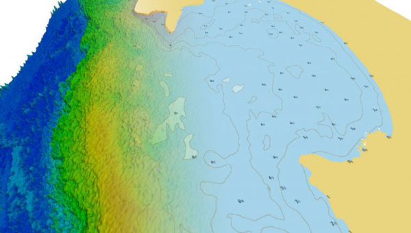
TCarta has introduced a new line of Satellite Reconnaissance Charts designed to complement official marine navigation maps in shallow waters. These digital maps, derived from recently acquired satellite imagery, adhere to International Hydrographic Organization S-57 and S-100 data model standards, mirroring the appearance and symbology of official navigation aids.
The TCarta Charts provide up-to-date information on seafloor depths, sandbars, reefs, shoals and other submerged hazards, as well as floating dangers in near-shore environments. The new products are particularly valuable for shallow water navigation, where official nautical map products, primarily designed for commercial shipping lanes, may lack detail.
Available in off-the-shelf 1:20,000 scale and custom 1:4,000 scale, the TCarta Satellite Reconnaissance Charts are delivered in file formats compatible with popular marine navigation software and common GIS platforms. This compatibility ensures easy integration into existing navigation systems.
These charts are designed to serve as a supplementary tool, providing mariners with additional information to navigate potentially hazardous near-shore environments more safely.
“Seen & Heard” is a monthly feature of GPS World magazine, traveling the world to capture interesting and unusual news stories involving the GNSS/PNT industry.
Photo: Alexey_Seafarer/iStock/Getty Images Plus
HOW BIG IS THAT BEAR?
Monitoring the weight of polar bears — an important health factor — usually means tranquilizing them from the air and lifting them with a tripod attached to a scale. However, technology might provide a non-invasive solution. Various zoos and sanctuaries are testing the accuracy of lidar scanners to measure the weight of polar bears, reports Geo Week News. The scans could be done using drones and mobile mapping equipment and techniques, according to Joel Cusick, a GIS specialist for the National Parks Service.
Photo: PaulFleet/iStock/ Getty Images Plus
SLIP SLIDING AWAY
Researchers used a combination of GNSS and interferometric synthetic aperture radar (InSAR) data from Sentinel-1 satellites to determine subsidence in
99 cities around the world between 2015 and 2020. Subsidence rates in Tianjin, Semarang and Jakarta exceed 30 mm per year. Even in mostly stable cities, areas are sinking faster than sea level is rising, with Istanbul, Lagos, Taipei, Mumbai, Auckland and Tampa sinking faster than 2 mm per year in some areas. Besides climate change, causes include groundwater extraction, mining, reclamation of natural wetlands, infrastructure projects and ecological disturbances. The study is published in Geophysical Research Letters.
Photo: NOAA Fisheries/Raymond Boland
FINDING NEMO
National Oceanic and Atmospheric Administration (NOAA) ocean mapping ship Rainier completed a five-month expedition to the Mariana Islands in September, combining mapping and charting with coral-reef ecosystem surveying. Collection of high-resolution mapping data in near real time improved the effectiveness of the traditional marine science data collection as the combined team mapped 4,000 square nautical miles of seabed and conducted 1,800 SCUBA dives. The data will improve navigation safety through updated NOAA nautical charts and increase understanding of coral reefs through the National Coral Reef Monitoring Program. Besides charts, the seabed mapping data supports marine protected areas, sustainable fisheries, and offshore wind siting — and, in the Marianas, is important for tsunami modeling.
Photo: mikulas1/iStock/Getty Images Plus
GRAVITY DOWN UNDER
An airborne gravity sensor is flying above 80,000 square kilometers of New South Wales (NSW), Australia, collecting data that will improve the accuracy of real-world heights from GNSS positioning to just a few centimeters. Data for the 18-month NSW Gravity Model project will be captured in five stages, starting in Western NSW. The resulting model is expected to enable better resource management, infrastructure planning and natural hazard preparation. It is also a critical building block for developing digital twins, replacing datasets that predate GNSS positioning.
The U.S. National Oceanic and Atmospheric Administration (NOAA) is seeking new members for its Hydrographic Services Review Panel, a federal advisory committee that advises the NOAA administrator on the agency’s hydrographic programs, products and technology.
“We depend on the perspectives of the people who rely on NOAA maritime products, especially for safety at sea or commercial efficiency, as we plan for improvements of our navigation data, services, and products,” said Russell Callender, Ph.D., assistant NOAA administrator for the National Ocean Service. “This panel is a vital part of our information gathering process to determine future priorities.”
The panel advises NOAA on hydrographic surveying, nautical charts, tides and currents, geodetic and geospatial measurements, and coastal preparedness.
Applicants should have expertise in one or more of the following fields:
marine navigation and technology,
port administration,
marine shipping or other intermodal transportation industries,
cartography and geographic information systems,
geodesy,
physical oceanography,
coastal resource management, including coastal preparedness and emergency response,
other related scientific fields.
Applications must be received by May 30;those received after the deadline will be kept on file and may be used for future panel vacancies. Members serve four-year terms, with meetings occurring at least twice a year.