James D. Litton, GPS pioneer and founder of NavCom Technology Inc., died over the weekend at his home in California with his family at his side. He was 89 years old.
Litton was an early contributor to the development of GPS user equipment. He also played a pivotal role in the GPS-driven transformation of global agriculture that has greatly benefited humanity.
Litton was the director of engineering at Magnavox Research Labs when researchers were working on using CDMA for range measurements, a precursor to the GPS system. He also worked on the original proposal for GPS Phase I.
Later, as general manager of Magnavox’s Marine and Survey Systems Division, he helped develop new and advanced commercial navigation and survey receivers for both the Navy’s TRANSIT system and the Air Force’s GPS.
His team developed the first microprocessor-based commercial satellite navigation receivers and the first commercial GPS survey software. This led to Magnavox eventually having more than a 90 percent share of the survey receiver market.
The firm eventually held more than two dozen patents for improvements in GPS technology.
In 1992, Litton left Magnavox to start a consulting business. Two years later, with Ron Hatch, K.T. Woo and Jalal Alisobhani, he founded NavCom Technology Inc. With Litton as CEO, NavCom became a significant player in the GPS marketplace. Among its achievements was development — under contract — of a single-frequency WAAS-capable GPS aircraft navigation receiver.
NavCom also began a relationship with Deere & Company, supporting more efficient and productive agriculture. This relationship was so successful that Deere purchased NavCom in 1999. Litton continued to lead the company and serve as part of Deere’s senior management team for eight more years.
In recognition of his many achievements to the field, Jim Litton was presented the Institute of Navigation’s Hays Award in 2006.
Among his many contributions, his impact on global agriculture might well have been his greatest, according to Brad Parkinson, the original chief architect for GPS.
“His work transformed agriculture into a data-driven, technological industry that was incredibly more efficient,” Parkinson said. “The cost savings and increases in productivity have impacted billions around the world.”
Jim’s family has created a memorial fund at Doctors Without Borders for those wishing to make a donation in honor of his life and many good works. Click here.
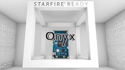
NavCom Technology Inc., a wholly owned subsidiary of Deere & Company, has released the Onyx multi-frequency GNSS OEM board.
Offering integrated StarFire/RTK GNSS capabilities, Onyx features 255-channel tracking, including multi-constellation support for GPS, GLONASS, Beidou and Galileo. It also provides high-performance in GNSS receiver sensitivity and signal tracking as well as patented multipath mitigation, interference rejection and anti-jamming capabilities.
Photo: NavCom
The new Onyx GNSS OEM board is a fully upgradeable GNSS receiver, allowing the receiver to be upgraded from free differential GPS signal sources such as WAAS to increased accuracy services with integrated features with StarFire, through software optioning alone.
The software-enabled features are sold in convenient software bundles, but can also be purchased individually, to suit changing application needs. Integrated StarFire is now simply activated via an over-the-air licensing system that sends a StarFire license via satellite directly to the StarFire-capable receiver from NavCom’s StarFire operations center.
StarFire, NavCom’s global satellite-based augmentation system (SBAS), provides real-time global 5-centimeter accuracy without a base station.
“The release of Onyx advances NavCom’s ability to grow products and services meeting the customer driven demands of uptime, accuracy, and feature rich capabilities,” said Steve Ault, NavCom’s GNSS product marketing manager. “NavCom continues to innovate the StarFire technology through the advanced capabilities inherent to Onyx which will be fully realized over the life of this new product.”
Last year at InterGeo 2015, UAVs ruled, for at least the second year in a row, although some of its newest-thing gloss seemed to be wearing off. This year, sensor integration in both hardware and software is a dominant theme — and one with broader implications and applications.
GNSS positioning technology, aided in many cases by laser scanning, other imaging sensors, total stations, Lidar and camera systems, all collaborating as inputs to mobile mapping systems or machine-control systems, together form a durable platform for many present and future applications.
NavCom booth at InterGeo.
Among the GPS/GNSS companies exhibiting here: CHC Navigation, ComNav Technology, Eos Positioning Systems, Hemisphere GNSS, Navcom Technology, NovAtel, Septentrio, and Tallysman.
“I think it’s a must for every surveyor to participate and get updated with all the developments,” said Chryssy Potsiou, president of the International Federation of Surveyors (FIG), “to try to make the best combination of tools and software so that we can have the best output, in order to provide reliable services at affordable prices, in short time. The world needs solutions, cheap and fast.”
Smart Cities. Along with the roar of the four connected exhibition halls where many new products are being rolled out on this premier world stage, there is a lot of talk — a lot of talk — in the presentation auditoriums about vision, and smart cities, and connectedness in it many forms, electronic and otherwise.
The international trade fair for geodesy, geoinformation and land management, InterGeo can be overwhelming, with roughly 550 exhibits from 33 countries, and 16,000 visitors from 92 countries. It spans everything from surveying, geoinformation, remote sensing and photogrammetry to complementary solutions and technologies, processing, using and analyzing geodata over the Internet and exploring new applications and solutions — it’s all here. Themes include mobility, energy supply, climate protection, and liveable cities and rural areas. Citizen involvement, data protection, data security and e-government all play a key role in future developments. This year, the conference published a pre-show report on geodata and what it calls Business World 4.0.
Host city Hamburg, an economically strong, vibrant city and one of the top three shipping ports in Europe, embraced digital strategy at an early stage. Sustainable city planning, climate protection, an intelligent mobility concept and IT-controlled port management are all aspects of the city that could not work without geodata.
Making Connections. “Our [geospatial] industry is now more and more related, more and more embedded with many other disciplines,” said Nigel Clifford, CEO of Ordnance Survey UK, who gave one of the conference keynotes. “One of the key questions we are facing is: What skills will the workforce of the future need to have, in order to flourish in this interconnected world?
“Some of the more obvious ones are digital capability, looking at data sciences. Also we spoke about some of the softer skills: the ability to look across disciplines, the ability to work with different functions, and really importantly, the ability for our industry to explain its value and be part of the decision-making which is going on around us all the time.
“We’re beginning to see the first fruits of the Internet of Things. There may be some inflated expectations at this point. It’s our job to test that. I’m confident there are some brilliant use cases developing over the next five years in the fields of health, transport, and community engagement. Making a city more efficient, more livable, more secure, and more business-friendly, to draw tax dollars into the equation. What we’re able to do today is so much more data-rich, so much more connected, than we’ve ever been able to do before. ”
He cited pilot public-private partnership projects in Manchester and another unnamed UK city going forward in this regard, with involvement from Cisco, Siemens, and British Telecomm along with Ordnance Survey. “It’s a mixed economy coming together, because there isn’t one answer.”
Looking into the future, he said “Developing nations in particular require a fundamental geospatial fabric in order to boost themselves. I hope there will be a broadening of the focus from what we can do absolutely at the cutting edge of technology with reasonably affluent societies, to thinking about how we can take that into the less affluent societies, and raise all boats through the efforts of this great industry.”
Gorillas Enter Room. Intel has taken a stake in the commercial drone space with its new Falcon UAV. “Predominantly, we are looking at inspections, construction, agriculture, as well as 3D modeling.” The company was joined by Oracle and Autodesk as first-time exhibitors at the show, and they did not enter timidly; big stands.
UAV über Deutschland. In moves shadowing those in the United States, the German Minister for Transport spoke about introducing regulations to govern civil and commercial use of UAVs. The newly published draft foresees the introduction of mandatory registration for unmanned aerial systems. Pilots will need a valid license to fly drones above 100 meters.
NavCom Technology’s Jim Williams explains the precise positioning and navigation solutions offered by the company for UAS (unmanned aerial systems) at Unmanned Systems 2015, held May 4-7 in Atlanta. It offers GNSS aerial antennas, RTK positioning and its StarFire global satellite-based augmentation system (GSBAS).