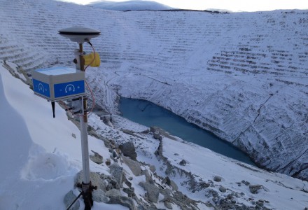
NavStar — a deformation monitoring company — has joined the Terra Insights platform of geotechnical brands.
NavStar develops specialized hardware and software for automated detection of movement on slopes and structures, with an emphasis on GPS/GNSS sensors. It provides a scalable and modular data-collection and presentation software platform.
“NavStar perfectly complements Terra Insights’ vision of being the global platform to provide trusted geotechnical, structural and geospatial monitoring technology and data delivery solutions,” said Mark Price, CEO, Terra Insights. “NavStar’s specialized expertise in automated deformation monitoring systems from both a hardware and software perspective expands Terra Insights’ core capabilities while pushing us further into the future.”
NavStar’s team of surveyors, engineers, technologists and software developers has been providing specialized GPS/GNSS solutions, products and support to clients around the world since 2001.
NavStar’s specialized GeoExplorer and deformation monitoring products are used by the mining, oil and gas, power, construction and government sectors.
“We are excited to join Terra Insights,” said Glen Bjorgan, manager of Field Operations at NavStar. ”Over the years we have worked extensively with the companies that make up the Terra Insights platform. Through that experience, we know that Terra Insights will be a great fit for NavStar and our customers.”
First, there was one. In July 1995, the U.S. Air Force declared the Global Positioning System had met all the requirements for full operational capability (FOC). Soon thereafter, there were two. In December of that same year, Russia’s Globalnaya Navigazionnaya Sputnikovaya Sistema (Global Navigation Satellite System, or GLONASS), also achieved FOC. For a quarter century, that was it.
Then, last year, the number doubled, as both the European Union’s Galileo and China’s BeiDou Navigation Satellite System (BDS, named after the Big Dipper asterism, which is known in Chinese as Beidou) achieved FOC.
The Indian Regional Navigation Satellite System (IRNSS, aka Navigation Indian Constellation, or NavIC, which means “sailor” or “navigator” in Hindi) and Japan’s Quasi-Zenith Satellite System (QZSS, also known as Michibiki) are not global yet, but plan to become so. Currently, NavIC is an autonomous regional satellite navigation system, and NavIC-based trackers are compulsory on commercial vehicles in India. QZSS currently complements GPS to improve coverage in East Asia and Oceania, but Japan plans to have an operational constellation of seven satellites for autonomous capability by 2023. The Korea Positioning System (KPS) plans to join the party by 2035.
Who’s next? Will it be another country or a private company? Given that the state-sponsored systems are free to end users, I don’t see what the business model would be for a private GNSS constellation, unless it were to piggyback on one built mainly for another purpose.
Surveyors who have begun to routinely use three or more constellations are over the moon. One, quoted in this month’s cover story, recalls that “the use of GPS for construction staking was an extremely risky proposition” because its residuals exceeded most construction tolerances. Using multiple GNSS constellations, however, has increased confidence in the accuracy of results to the point that some construction companies are relying on GNSS receivers for staking. Additionally, multi-constellation receivers can now increasingly be used under tree canopies and against structures, whether natural or built.
Whatever their mix of military, political and commercial motivations for building, deploying and operating their own GNSS constellations in addition to the original two, the European Union, China, India, Japan, Korea and whichever entity may follow are greatly improving satellite-based positioning, navigation and timing (PNT) for all users everywhere — by increasing accuracy, shortening the time to first fix, and making GNSS more impervious to jamming and spoofing.
In 1978, the year that the U.S. Department of Defense launched the first NAVSTAR GPS satellite (“NAVSTAR” was later dropped from the system’s name), Neil Young sang “Four Strong Winds” (originally written by Ian Tyson and performed by him with his wife Sylvia as the Canadian folk-duo Ian and Sylvia).
Now, GNSS has “four strong winds,” two lighter ones and several more breezes to follow. As a sailor and a navigator, I welcome them heartily. As this magazine’s editor-in-chief, I don’t mind that, like Jeep, Kleenex, Popsicle and Xerox, GPS probably will stick in popular culture as a generic term for global satellite navigation systems way past its accurate description of what is in the box.
The Air Force Space and Missile Systems Center has published minutes for the 2020 Public Interface Control Working Group (PICWG) and Open Public Forum help on Sept. 30, 2020, for the following NAVSTAR GPS public documents:
IS-GPS-200 (Navigation User Interfaces)
IS-GPS-705 (User Segment L5 Interfaces)
IS-GPS-800 (User Segment L1C Interface)
ICD-GPS-240 (NAVSTAR GPS Control Segment to User Support Community Interfaces).
The meetings were held to update the public and collect issues and comments for analysis and possible integration into future GPS public document revisions, according to the U.S. Coast Guard Navigation Center (CGSIC).
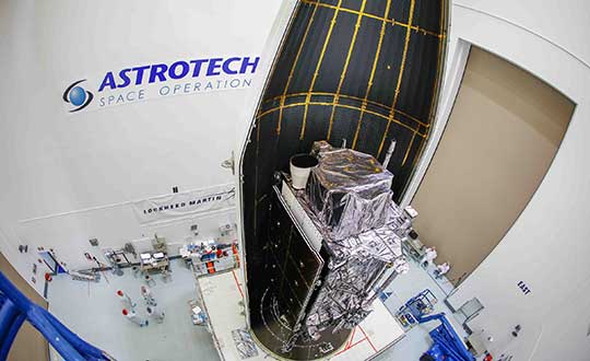
The second GPS III satellite, nicknamed Magellan, has been designated healthy and usable.
According to a Notice of Advisory to Navstar Users (NANU) issued by the U.S. Coast Guard, the satellite has been designated usable as of April 1, 1945 ZULU.
The 2nd Space Operations Squadron (2 SOPS) accepted control of the Magellan on March 27 at the Schriever Air Force Base in Colorado.
Designated Satellite Vehicle Number 75 (SVN75) in the GPS constellation, Magellan is the second GPS III satellite to be accepted into the program, and the first to be accepted during a global pandemic.
The second GPS III satellite is encapsulated before launch. (Photo: Lockheed Martin)
“We’re continuing to make major strides even while working through this pandemic, and we continue to expand our capability to further the program along,” said Lt. Col Stephen Toth, 2 SOPS commander. “This is a huge, momentous occasion for us, that we’re reaching this milestone, that our programs are being delivered, that they’re being executed and the systems are performing as expected. Ultimately, we’re all very excited that we’ve accomplished this major milestone in the program’s history, and we’re very excited for the next things to come.”
The new generation of GPS III vehicles have a 15-year design life and signals that are three times more accurate than the current generation.
“[This means users will have] better accuracy anywhere in the world, with a user’s device being able to determine their location more reliably,” said Capt. Ryan Thompson, 2nd SOPS assistant director of operations.
Additionally, the new satellites have eight times improved anti-jam capability, allowing the military warfighter to operate better in contested, degraded and operationally limited environments.
The vehicles are designed to be forward and backward compatible, which allows them to adapt to the future while remaining fully adaptable to the previous generation of vehicles.
Eight more GPS III satellites are scheduled to launch from now until 2025.
Despite any challenges that may arise, 2nd SOPS remains focused on the mission and continues to make history in space.
“As we’ve moved forward into the Space Force, we’ve taken a bigger mindset approach toward being warfighters,” Toth said. “What COVID has actually brought out of us is the full understanding of what it is to operate with a warfighter mindset. We may not be at war with an enemy per say, but we are definitely at war with the virus. My job is to ensure we continue to provide position, navigation and timing to the world. And we take that very seriously, so despite the virus, we’ll ensure that our mission continues.”
The U.S. Air Force is holding a 2016 Public Interface Control Working Group and Open Forum for the Navstar GPS public documents Sept. 21-22 in El Segundo, California.
The meeting is intended to update the public on GPS public document revisions and collect issues and comments for analysis and possible integration into future Navstar revisions.
The forum will be held for the following documents:
IS-GPS-200 (Navigation User Interfaces).
IS-GPS-705 (User Segment L5 Interfaces).
IS-GPS-800 (User Segment L1C Interface).
ICD-GPS-240 (Navstar GPS Control Segment to User Support Community Interfaces).
ICD-GPS-870 (Navstar GPS Control Segment to User Support Community Interfaces).
The 2016 Interface Control Working Group and Open Forum is open to the general public. The meeting will be held in the Great Room at 100 N. Sepulveda Blvd., El Segundo, California, 90245.
Those planning to attend should register by Sept. 7. To register, send the registration information to [email protected], providing your name, organization, telephone number, email address and country of citizenship.
U.S. Air Force Space Command is now testing CNAV capabilities on the GPS L2 and L5 signals. The initial CNAV Live-Sky Broadcast began June 15 and will take place until June 29. Civil users and manufacturers are invited to participate.
The GPS Directorate (SMC/GP) is implementing the CNAV (Civil Navigation) Test Program, conducting Live-Sky CNAV testing before deployment of the Next Generation Operational Control System (OCX). CNAV is a capability to be provided by Civil Navigation message types for the purpose of improved GPS navigation through the use of signals L2C and L5.
According to the GPS Directorate, the CNAV Live-Sky testing program will span several years and will evolve to support GPS enterprise and modernized civil navigation performance objectives. Objectives include:
Verify and validate the CNAV requirements specified IS-GPS-200F and IS-GPS-705B.
Facilitate the development of robust IS-compliant L2C and L5 civil receivers.
Below is the latest Notice Advisory about the upcoming test issued to NAVSTAR users. More information can be found in the NAVCEN test plan PDF.
NOTICE ADVISORY TO NAVSTAR USERS (NANU) 2013034 NANU TYPE: GENERAL
*** GENERAL MESSAGE TO ALL GPS USERS ***
The purpose of this notification is to inform users of an upcoming event related to the GPS satellite constellation. Air Force Space Command will be
testing CNAV capabilities on the GPS L2C and L5 signals on Jdays 2013/166-2013/182. There are no planned GPS satellite outages or degradations for this activity. L2C and L5 CNAV message testing should be transparent to GPS receivers that do not process L2C or L5 CNAV. These test events will provide an opportunity for civil users and manufacturers to participate in L2C and L5 evaluation. Details on the test plan are located at the NAVCEN web page. Any military or civil users who encounter user equipment problems during or after testing should contact the applicable POCs identified below as soon as possible. Aviation users should file reports consistent with FAA-approved procedures. Users are cautioned that L2C and L5 signals are not operational.