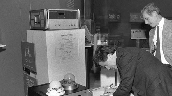
Feature image: Smithsonian; Charlie Trimble provides the 4000A GPS Locator to the Smithsonian Museum. Introduced in 1984, the Trimble 4000A was the first commercial GPS positioning product.
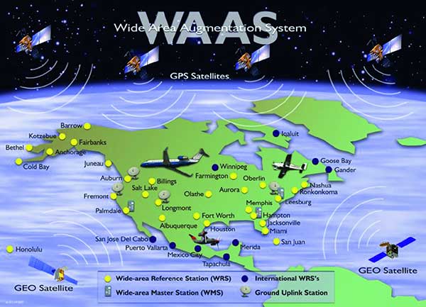
Thirty years ago, NAVSYS was deep into the development of the Wide Area Augmentation System (WAAS). I had the honor of being the chair of the RTCA SC-159 Integrity Working Group, which developed the first concepts for what evolved into three integrity standards for GPS: multi-sensor integration, receiver autonomous integrity monitoring (RAIM) and wide-area differential GPS using a GPS integrity channel (GIC) to broadcast corrections over a geostationary overlay.
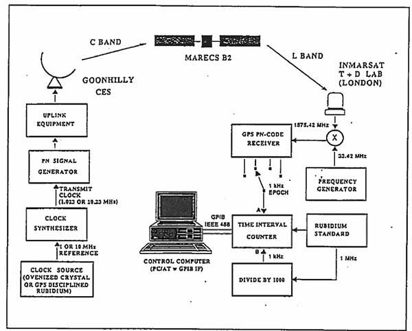
NAVSYS, working with Inmarsat Corporation, built the first prototype WAAS SIGGEN equipment, which was deployed at the Coonhilly Coast Earth Station and used to transmit an L-band C/A-code signal over the Inmarsat Atlantic Ocean Region MARECS-B satellite to a software GPS receiver that we had developed and installed at Inmarsat’s Test and Development Laboratory in London.
First Inmarsat Geostationary Overlay Test-Bed, 1991. (Image: NAVSYS)Image: FAA
This evolved into the FAA’s WAAS program, which used the NAVSYS SIGGEN for the initial deployment, test and evaluation. The algorithms developed by NAVSYS were ultimately licensed to Raytheon for use on the operational WAAS and MSAS systems.
The U.S. Department of Homeland Security “did exactly what was required by Congress” in issuing its report in June on positioning, navigation and timing (PNT), according to a letter sent by numerous PNT companies to the DHS.
The July 17 letter to Chad F. Wolf, acting secretary of Homeland Security, refutes a previous letter from Congressional representatives that the report contained numerous errors and failed to address many of the things Congress had required.
“We believe that some key claims made in the members’ letter of June 9 are either exaggerated, irrelevant to the report’s Congressional tasking, or simply wrong,” states the July 17 letter, which is signed by senior executives of Satelles, Orolia, Iridium, Navsys, Jackson Labs, Seven Solutions and Qulsar.
The group takes on the claims of the representatives point by point, finding them exaggerated, irrelevant or incorrect.
For instance, the letter critical of the DHS report states:
“The report focuses on the needs of ‘industry’ largely ignoring the needs and impacts on public services (including first responders), government operations, and individual citizens.”
In response, the industry representatives state:
“The focus of the report, as directed by the NDAA, is on the requirements of the owners and operators of national critical infrastructure. This includes “public services, government operations,” and its beneficiaries, “individual citizens.” To the extent that the report focuses on incentivizing the industry, it is in order for it to be able to meet these requirements.
“While the report only highlights PNT use cases from a subset of the 16 critical infrastructure sectors, their pragmatic recommendations address a range of requirements across all sectors. With respect to PNT needs for backing up GPS, DHS acknowledges the differences between and commonalities among the sectors and offers exceptional guidance for leveraging the capabilities of diverse forms of commercially available alternative PNT rather than endorsing a single, anti-competitive, government-imposed solution.”
A networked radio from Thales is designed to meet soldiers’ need for assured positioning, navigation and timing (PNT) while on foot.
The MBITR2 is part of a broader defense effort to provide PNT solutions in case of GPS jamming or interference. The MBITR2 is one of a number of devices and technologies, many still in development, to address this need.
For instance, under a Small Business Innovation Research (SBIR) contract with the Air Force Research Laboratory, Navsys Corporation is testing a network-assisted PNT acquisition algorithm to run on tactical radios such as the MBITR2. The algorithm is designed to provide improved acquisition performance in a GPS jammed environment by leveraging an innovative assisted GPS (A-GPS) architecture where navigation and timing data are shared across the tactical radio network.
The AN/PRC-148B MBITR2 ground tactical handheld radio is small, light and power-efficient. It builds on the legacies of both the earlier narrowband AN/PRC-148 MBITR tactical handheld radio and the wideband AN/PRC-154 tactical handheld radio. It covers the 30–512 MHz frequency range.
When equipped with the MBITR2, dismounted warfighters can connect with the wideband tactical Internet protocol and the voice network via the Soldier Radio Waveform wideband channel, while maintaining contact via the legacy narrowband channel.
The MBITR2 is interoperable with MBITR radios already deployed. More than 200,000 are now in the field, and Thales said the earlier generation radios can be upgraded with a low-risk and cost-effective approach.
Further, the MBITR2 retains compatibility with the existing installed base of ancillaries.
MBITR2 features
Two radios in one
Simultaneous two-channel (narrowband and wideband) operations
Adds a second wideband channel to the AN/PRC-148 to provide networking, data, and video capability
Retains the existing AN/PRC-148 JEM Type-1 capabilities and waveforms
Navsys Corporation received the 2016 James S. Cogswell Outstanding Industrial Security Achievement Award, the highest honor the Defense Security Service (DSS) presents to cleared industry partners, for its facility in Colorado Springs, Colorado.
Founded in 1986 by Alison Brown, NAVSYS has assisted other small businesses, including partner GPS Source, in establishing security programs for GPS products.
The company conducts research and development on global navigation technologies and specializes in GPS hardware design, systems engineering, systems analysis and software design for government and commercial customers.
How Navsys Leverages Military Expertise for Business
The financial landscape is changing in a number of ways for a lot of GNSS businesses due to the U.S. government sequester and to a larger extent due to the U.S. reduction in military spending. The larger multinationals and prime contractors may have achieved pretty well diversified scope for their operations, and most have existing commercial products or operations where they can pump up resources and investment to improve their commercial market and product positioning. But a number of small businesses have discovered that their military and government clients of the past no longer have the same level of funding available for key projects. So their search is on for commercial opportunities, and the transition to a commercial business model may present a significant change in the way they operate.
Navsys Corporation in Colorado Springs is located just outside the gates of the U.S. Air Force Academy, so it’s not unusual that its customer base reflects a close association with the U.S. military and its prime contractors.
When someone in the military had a challenging GNSS or related technology problem in the past, it was often Navsys who was able to offer an innovative solution, through a Small Business Innovation Research (SBIR) proposal — and the company was actually awarded nine SBIR Phase II contracts over the last five years. Phase II SBIR contracts are designed to transition mil technology into commercial products either via government organizations or commercial outfits. Often in the past, prime contractors responding to a larger mil-spec requirement would also roll Navsys into their response when part of the requirement involved a GNSS navigation or related solution. So since 1989, the development of GNSS technology and products, and the publication of papers describing those technologies and products, have been pretty continuous at NAVSYS:
Extended wide area differential GPS
WAAS bent-pipe signal generator (SIGGEN)
GPS/inertial video registration
Digital beam-steering GPS receiver
JLOC Jammer Detection and Location system
Indoor location
GPS phased sensor array
Software-defined receiver
JLOC has been a long-term active government project for more than 10 years. SIGGEN technology has been part of Japan’s MSAS system for more than 10 years, and is an example of a successful product that has transitioned from government research into the commercial sector. And, of course, the first GPS-enabled cell phone, developed by Navsys Corporation, is now on display at the Smithsonian National Air and Space Museum’s Time and Navigation exhibition in Washington, D.C. Developed for the Colorado Department of Transportation’s Emergency Vehicle Location System Mayday platform in 1995, this important step in GPS history paved the way for positioning to become an integral component of today’s communications technology.
The complement of professionals on staff at Navsys has changed throughout the years, driven largely by how many projects were contracted at any one time, but the group has always had a very high standard of qualifications and experience and has inevitably exhibited a large degree of flexibility and creativity. Nowadays, moving to better align with commercial opportunities, Navsys helps companies solve challenging problems relating to GNSS, inertial, and simulation/testing. Cultivating business-to-business partnerships allows the company’s technical expertise to compliment and strengthen end-user products or applications. So companies are able to use Navsys as a technical resource for product development at a lower cost than developing their own in-house navigation solutions. And many of the technologies and core capabilities that they turn to stem from prior research and development into government and military applications. As projects mature, they transition into industry-leading products and services. Navsys’ industry partners and customers then go on to customize these capabilities into commercial applications in the marketplace.
One of the key technology/products that Navsys is pursuing includes InterNav modular GPS/inertial embedded software. It provides a real-time tightly coupled GPS/inertial solution that can be precisely aligned with additional sensors, including digital video products and laser rangefinders.
InterNav software provides geo-registration for SAFIRE. Photo: NAVSYS
InterNav software may be embedded into OEM applications including commercial-off-the-shelf GPS/INS systems, unmanned platform navigation and stabilization systems, and remote sensing geo-registration. The above graphic shows how InterNav provides highly accurate geo-registration for FLIR’s Star SAFIRE electro-optic imaging system.
With other key customers such as KVH also using InterNav in some of its integrated inertial products, Navsys appears to be well on its way to penetrating a market segment that has previously been a space occupied by companies such as Applanix, Teledyne, and iMAR.
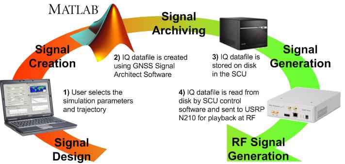
Another area where Navsys has had some success is GNSS simulation and test. The GNSS Signal Architect product suite includes Simulation and Toolbox software and test-set hardware.
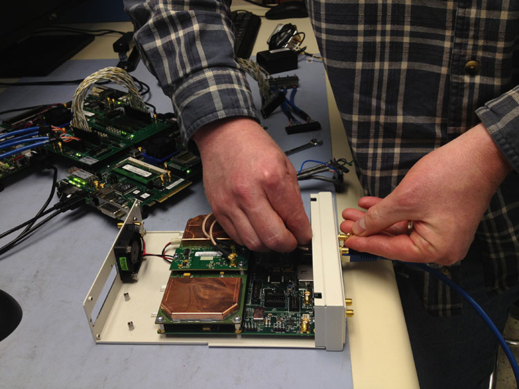
Photo: NAVSYS
Simulations of GPS or GLONASS are created based on static or dynamic scenarios. Users specify a complete set of simulation parameters, including receiver/satellite profiles and delay/noise error modeling. Playing back the simulation as an RF signal provides accurate and repeatable signals for GNSS receiver testing.
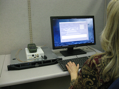
Signal architect user. Photo: NAVSYS
Toolbox includes a number of GNSS MATLAB utilities, including geographical, satellite geometry and receiver design/analysis tools. Test set is made up of a signal control unit computer and a software-defined radio and includes a wideband transceiver daughterboard.
Navsys has in the past provided extremely accurate GPS scenario generation software for end-user GPS simulator products, and the SatGen GNSS signal generator has also been released by Racelogic using Navsys Signal Architect Signal Simulation software.
Other technology/products currently in the works include Precision Geo-Registration and Remote Sensing, Geo-Referenced Imagery, Video-Aided Inertial Navigation and GNSS/Inertial Simulation.
GPS/inertial InterNav technology has been used to develop Precision Geo-Registration and Remote Sensing,which extracts precise coordinates from video imagery without requiring any known data points. The key technology advantage is a precision GPS/inertial alignment technique that enables accurate camera alignment and aiming (<1 mrad attitude) using only low‐grade inertial sensors.
Video-Aided Inertial Navigation uses an algorithm update technique that leverages image aiding from tracking ground points to further refine alignment accuracy. When combined with the GPS/inertial alignment algorithm, significantly improved alignment accuracy can be achieved over current GPS/inertial integration approaches.
Photo: NAVSYS
So, as defense spending continues to contract, Navsys and other similar companies with an existing “treasure chest” of technology created for previous military programs are successfully adapting. Not only are skillfully modified, repackaged or even further advanced technologies and products being brought to the commercial marketplace, but their approach to business development, marketing and sales is beginning to take on the face of commercial operations. Business plans, carefully chosen projects and internal investment are beginning to replace responses to Commerce Business Daily (CBD) and Federal Business Opportunities (FedBizOpps) as a way to conduct business. It’s a brave new commercial world out there and Navsys amongst others is ready, prepared and able to adapt and succeed.
WASHINGTON, D.C. — The first GPS-enabled cell phone, developed by Navsys Corporation, is now on display at the Smithsonian National Air and Space Museum’s Time and Navigtion exhibition, which opened today. This device marks an important step in GPS history that paved the way for positioning to become the integral component of communications technology that exists today, Navsys said.
Navsys assisted in the development of the Colorado Department of Transportation’s Emergency Vehicle Location System Mayday platform in 1995. To address the need for faster notification and responsiveness during emergencies, Navsys was contracted to integrate GPS positioning into a cell phone so that location information could be sent to a communications center for mobile 911 calls.
One of the enabling technologies Navsys developed for this system was LocaterNET. When activated by a user’s in-vehicle unit (IVU), LocaterNET collects a snapshot of raw GPS information. That information is then sent to a remote processing system to determine the user’s location. This technique allowed for low power consumption and processing requirements for the IVU, which is vital for small form factor personal navigation and communication devices.
“We are honored to be a part of this exhibition and for the awareness it creates for how GPS technology has advanced many other technologies we use today,” said Alison Brown, president and CEO of Navsys.
The Smithsonian exhibition covers a multitude of navigation and timing innovations and opens on April 12. A detailed description of the LocaterNET Mayday platform can be found here.