Tag: Next Generation Operational Control System

  • GPS upgrade: SMC shares constellation modernization plans

    GPS upgrade: SMC shares constellation modernization plans

    By Col. Ryan Colburn
    Director, Spectrum Warfare Division and Portfolio Architect,
    Space and Missile Systems Center

    The United States’ Global Positioning System is used now more than ever before. With an estimated four billion users worldwide, industries of all kinds continue to leverage the precise and consistent data streaming from the GPS satellites. The universal use of GPS signals permeates our lives and creates positive impacts around the globe.

    We continue to deliver on our decades-long commitment to provide precise positioning and timing data to the civil, commercial and scientific communities. To support the evolving use of this global utility, the government and industry GPS Enterprise team has embarked on major investments to modernize GPS capabilities for our stakeholders. These efforts are occurring across all of our segments and combine to deliver incremental capabilities and improvements over time.

    Colonel Ryan Colburn leads the team dedicated to modernizing the GPS constellation to meet tomorrow’s needs. (Photo: U.S. Space Force)
    Colonel Ryan Colburn leads the team dedicated to modernizing the GPS constellation to meet tomorrow’s needs. (Photo: U.S. Space Force)

    GPS ENTERPRISE ROADMAP

    The GPS Enterprise Roadmap is an overview of the many programs we have in execution or planning stages. These efforts will enable us to deliver new and improved positioning, navigation and timing (PNT) capabilities across all segments. We are upgrading each of the three GPS segments (space, control, and user equipment) to deploy modernized capabilities while continually replenishing the GPS constellation; ensuring we have 24 or more operational satellites available at least 95% of the time.

    Additionally, we are always working on what’s next. We are actively researching, prototyping and planning; looking at how we will continue to evolve this architecture into one that is more robust and resilient than it is today. Our team is working to define the next set of capabilities for not only the GPS, as the backbone of our architecture, but also for ways to build off of this system and expand our ability to deliver PNT capabilities in new and useful ways.


    “We continue to deliver on our decades-long commitment to provide precise positioning and timing data to the civil, commercial and scientific communities.”


    2021 UPCOMING MILESTONES

    Space Segment

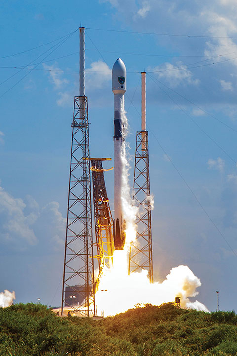
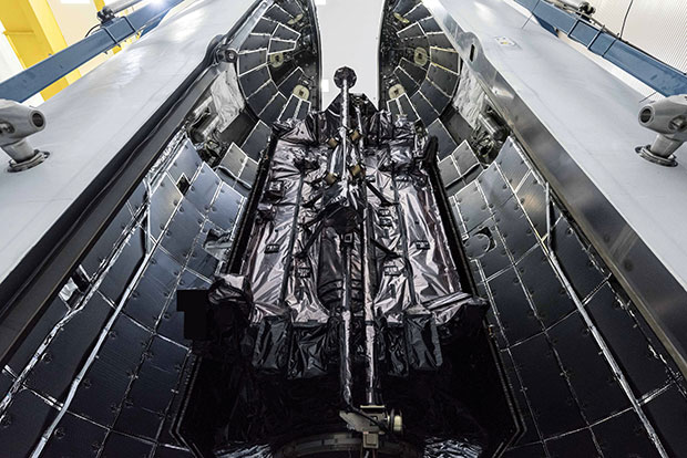
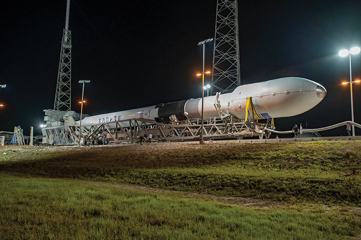
    The GPS III program is off to a great start, further enhancing military readiness and bolstering the activities and assurance of all GPS users. The program continues to push space acquisition boundaries with the first reuse of a Falcon 9 rocket for a National Security Space mission.

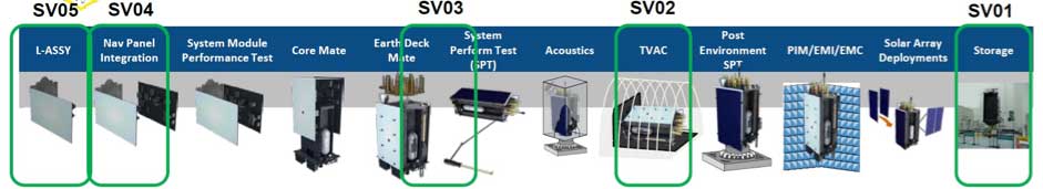
    Slated for launch in June, SV05 will launch on a flight-proven Falcon 9 booster that was recovered after successfully launching SV04 into orbit.

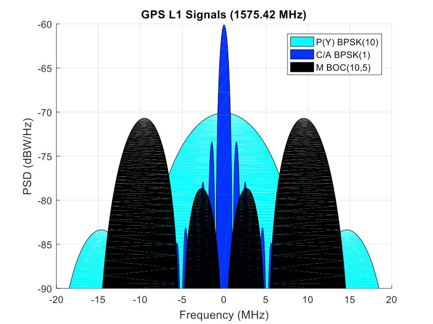
    SV05 will continue the GPS constellation modernization effort and will deliver users a bump in performance and accuracy. The satellite features the interoperable L1C signal, the newest civilian L5 signal and anti-jamming improvements. For the military user, SV05 will become the 24th military-code (M-code) satellite, bringing M-code utility to its Initial Operating Capability.

    The GPS III SV03 satellite is encapsulated in its protective launch fairings. (Photo: U.S. Space Force)
    The GPS III SV03 satellite is encapsulated in its protective launch fairings. (Photo: U.S. Space Force)

    Ground Segment

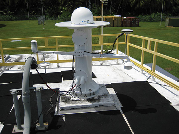
    2021 will be a big year for the Next Generation Operational Control System (OCX). OCX will soon complete the installation of an entirely modernized network of 17 global monitoring stations. These stations allow OCX to monitor the full suite of legacy as well as modernized military and civil navigation signals, including L2C and L5.

    In the factory, OCX will continue to use a newly accredited GPS System Simulator (GSYS) in support of mission software testing. In parallel, OCX will continue to replace mission equipment with Hewlett-Packard Enterprise hardware prior to its deployment to operational sites. Once deployed, connections to the GPS command and control antennas will begin, and interconnections to other mission systems will be established.

    This includes the GPS Global Information Grid Automated Information System (GGA) subsystem, which will ensure timely dissemination of important navigation data to the public. OCX’s Launch and Checkout System (LCS) will be used to launch and initialize GPS III SV05.

    OCX 3F is a modification of the OCX baseline to support GPS IIIF-specific mission requirements. OCX 3F will maintain backward compatibility with the existing systems to support the legacy GPS constellation and will integrate future GPS IIIF capabilities. For example, it will implement command and control of the Regional Military Protection (RMP) and Rapid Warfighter Effects requirements. We are on track for an OCX 3F contract award later this year.

    A GPS Antenna is installed at the Diego Garcia Tracking Station, part of the Satellite Control Network operated by the Space Force. (Photo: U.S. Space Force)
    A GPS Antenna is installed at the Diego Garcia Tracking Station, part of the Satellite Control Network operated by the Space Force. (Photo: U.S. Space Force)

    User Equipment Segment

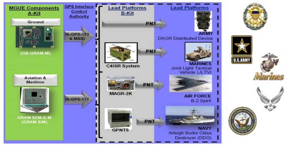
    In 2021, Military GPS User Equipment (MGUE) Increment 1 will culminate its ground user form factor efforts by completing a Field User Evaluation (FUE) of M-Code GPS technology in two service-nominated lead platforms. The Army FUE will be conducted with multiple variants of Stryker vehicles.

    Meanwhile, the U.S. Marine Corps will use the Joint Light Tactical Vehicle (JLTV) for their FUE. Both events will assess the performance of the enhanced GPS receivers in operationally relevant environments. Toward the end of 2021, MGUE Increment 1 will deliver the aviation/maritime form factor, which will enable Navy Guided Missile Destroyer (DDG) and USAF B-2 bomber lead platform integration in 2022.

    GPS III SV03 is rolled out to the launchpad (above) before its daytime launch on June 30, 2020 (left). The M-code-enabled satellite was joined by SV04 in December. SV05, the 24th M-code-enabled satellite, is expected to launch by July 2021, completing the Initial Operating Capability of M-code. (Photo: U.S. Space Force)
    GPS III SV03 is rolled out to the launchpad before its daytime launch on June 30, 2020.

    Enterprise Integration

    None of these systems are delivered in a vacuum, and we work hard to integrate them all. It is the only way we can continue to deliver on our promises outlined in our published standards. From test campaigns and requirements management, to model-based systems engineering and roadmaps; it takes a united team of government and industry partners to deliver truly integrated capabilities.

    We have many exciting milestones this year and we have a world-class government and industry team working tirelessly to ensure continued delivery, maintenance, and operations of GPS Enterprise capabilities. Our motivation is simple — continuing to deliver and evolve the gold standard PNT capabilities we all rely on day in and day out.

    The U.S. Space Force’s Space and Missile Systems Center (SMC), located at the Los Angeles Air Force Base in El Segundo, California, is the center of excellence for acquiring and developing military space systems. The SMC’s portfolio includes space launch, global navigation satellite systems, military satellite communications, a meteorological satellite control network, range systems, space-based infrared systems, and space situational awareness capabilities.

    The M-code-enabled SV03, shown launching in June 2020, was joined by SV04 in December. SV05, the 24th M-code-enabled satellite, is expected to launch by July 2021, completing the Initial Operating Capability of M-code. (Photo: U.S. Space Force)
    The M-code-enabled SV03, shown launching in June 2020, was joined by SV04 in December. SV05, the 24th M-code-enabled satellite, is expected to launch by July 2021, completing the Initial Operating Capability of M-code. (Photo: U.S. Space Force)
  • OCX supports second GPS III launch

    OCX supports second GPS III launch

    GPS OCX will maneuver satellite into final orbit over 10 days

    The U.S. Air Force used Raytheon Company’s GPS Next-Generation Operational Control System, known as GPS OCX, to support the launch of its second GPS III satellite into space. The ground system will now spend 10 days maneuvering the satellite into its final orbit, demonstrating GPS OCX’s ability to simultaneously support multiple GPS III spacecraft on-orbit throughout the checkout and calibration process.

    Raytheon’s GPS OCX has obtained the highest level of cybersecurity protections of any Department of Defense space system.

    “GPS OCX performed extremely well during the first launch and has exceeded performance requirements in the months since,” said Dave Wajsgras, president of Raytheon Intelligence, Information and Services. “The team was well-prepared for this launch, and we’re confident the system’s performance will continue to be positive.”

    GPS OCX, the enhanced ground control segment of America’s GPS system, has achieved the highest level of cybersecurity protections of any Department of Defense space system. Its open architecture design allows it to integrate advanced protections as they become available, and the system’s industry-leading cyber protections are why it will be used to support all future GPS III launches and GPS constellation operations upon operational acceptance.

    Earlier this year, the team completed final qualification testing of the system’s modernized monitor station receivers, which can receive and decrypt all GPS III military and civil signals. Global installation of the receivers starts next month and keeps the program on track for full system delivery by the program’s June 2021 contractual deadline.

    In addition to GPS OCX’s role, RGNext, a joint venture between Raytheon and General Dynamics Information Technology, provided operational launch support to ensure the safe launch of the United Launch Alliance’s Delta-IV rocket that was carrying the GPS III satellite. RGNext operates the launch range on behalf of the U.S. Air Force, providing maintenance, range safety, weather monitoring, communication and surveillance support for all launches conducted by defense, civil and commercial companies at the range.
    To access our press kit, which includes photos, videos and an animation, please visit us here. To learn more about the program’s progress and additional capabilities, visit us here.


    Featured photo: Raytheon

  • The promises of M-code and quantum

    November has certainly been a busy month, and I’ve been lucky enough to be involved in a number of standout events where defense PNT was discussed.

    The National Space-Based Positioning, Navigation, and Timing (PNT) Advisory Board met in California; GPS World hosted a webinar on military PNT technology; and the International Navigation Conference took place in the U.K. Check out a brief roundup of what’s been taking place.

    Next-generation GPS takes steps in the right direction

    The December issue of GPS World magazine has an excellent update from Col. Steven Whitney. GPS itself is often referred to as the “gold standard” by which other GNSS and PNT solutions are benchmarked. And GPS is undergoing a fairly monumental modernization program, in order to stay current and provide the right services to the military. There are broadly three aspects to this: the next-generation ground segment, the space segment, and the user equipment.

    It’s fair to say that the ride hasn’t been a particularly smooth one, and the Next Generation Operational Control System (OCX) has been plagued by delays and challenges. Following a Nunn-McCurdy breach in 2016, the future of the OCX development program looked to be hanging on a knife edge, but the program was recertified and continued.

    At the PNT Advisory Board meeting on Nov. 15, Col. Gerry Gleckel (deputy director, GPS Directorate, Space & Missile Systems Center) gave an upbeat presentation on the status of GPS modernization. Describing the current status of OCX as “working through program challenges,” he described how the first integrated launch rehearsal between GPS III and OCX Block 0 had been completed in August.

    The GPS III satellites themselves are in full production flow, with five satellites at various stages of assembly.

    Figure 1. Five GPS III satellites are in production flow. (Credit: Gerry Gleckel, Nov. 15, 2017).

    The next-generation military receivers, known as Military GPS User Equipment (MGUE), are also under development by a range of vendors, of which L-3 Technologies was the first vendor to receive security certification in 2016. A number of equipment form factors are being developed to address land, sea and air platforms, and great progress is being made.

    Figure 2. Military GPS User Equipment (MGUE) will address a range of platforms. (Credit: Gerry Gleckel, Nov. 15, 2017)

    The U.S. Air Force recently completed a number of successful test flights of a prototype M-code receiver on board a B-2 stealth bomber, which marks an important milestone for the GPS modernization effort. Let’s remind ourselves what M-code is, and what it does for us.

    The promise of M-code

    Until now, the military has relied on the encrypted P(Y) code to provide advantage on the battlefield. Compared to the civilian C/A code, the P(Y) offered improved accuracy, ionospheric correction, resistance to spoofing and a marginal level of jamming resistance.

    M-code is quite a different picture. Rather than the traditional BPSK modulation schemes used by legacy signals, M-code utilizes a type of binary offset carrier (BOC) signal. In the case of M-code, the signal is a BOCsin(10,5) modulation, which has a power spectral density given by:

    This power spectral density can be seen in the figures below, along with legacy C/A and P(Y) codes (and also the new L2C signal on L2). The M-code BOC signal has a number of important properties; I won’t describe all of them, but I will pick out a couple.

    Firstly, the signal is able to support navigation warfare activities. Because the energy in the signal is spread in two lobes away from the center, it allows for the C/A code to be selectively jammed without affecting the military receivers. This is often referred to as “blue force jamming” or “blue on blue jamming,” where friendly forces might wish to perform jamming in an environment in which they are themselves operating. Currently, such blue force jamming is not possible with P(Y) code receivers, without also degrading the friendly force’s receiver.

    Another promise of M-code is the ability to use spot-beam transmissions from Block III satellites. This is where a high-gain antenna on the satellites aims the M-code signal at a specific region of the earth, with much greater received satellite power in that region. The received signal from the spot beam is expected to be around 20-dB more powerful than the conventional full-Earth coverage beam. This means that, in a given conflict region, military GPS receivers should be able to benefit from a large increase in jamming resistance.

    Figure 3a. M-code signal compared to traditional L1 GPS signal. (Image: Michael Jones)
    Figure 3b. M-code signal compared to traditional L2 GPS signal. (Image: Michael Jones)

    Shortly after the GPS Advisory Board meeting in California, on the other side of the Atlantic a range of defense PNT technologies was also discussed.

    International PNT experts gather in the UK

    The International Navigation Conference (INC 2017) is now in its third year, and has been steadily growing in prominence. This year’s event, which took place Nov. 27-30, focused on the themes of resilient PNT, autonomy, and sensor and data fusion. As usual, there was a substantial defense presence.

    I had the pleasure of chairing a few sessions, including a panel discussion on resilient PNT. The event began with a cross-government meeting, where representatives from across the UK government met to discuss PNT issues concerning defense and national security.

    What I loved about this conference is the sheer diversity of PNT topics that were discussed. In the military domain, it wasn’t just the traditional subjects of GNSS, inertial, visual and signals-of-opportunity that were discussed. Also considered was cognitive navigation — how does a soldier’s brain work when in an unfamiliar battlefield? And how will quantum technology benefit defense PNT in the medium to long term?

    The promise of quantum

    Quantum technology has for some time been touted as the future of PNT: clocks so accurate that you’ll never need to worry about timing again. Inertial measurement units that have so little drift, you’ll never need anything else for navigation.

    If you’re not familiar with quantum technology, let me explain. Quantum technology exploits science that cannot be explained by classical physics, such as Newtonian mechanics, thermodynamics and Maxwell’s electromagnetism.

    As atoms get colder, they have lower energy levels and move more slowly. Taking this argument all the way down to absolute zero, the atoms would stop moving. By using lasers to cool atoms to very near absolute zero, the atoms are essentially placed under precise control, and hence are sensitive to changes in the local magnetic and gravitational fields. What does this mean for navigation?

    An excellent INC 2017 session on quantum navigation revealed some of the answers. Dr. Tim Freegarde of the University of Southampton gave the keynote “Navigator’s Introduction to Quantum Technologies,” which was followed by sessions on quantum/classical combined navigation, and quantum technology for performing gravity gradient map matching.

    Quantum sensors rely on a phenomenon known as entanglement, where two physically separated systems are linked in such a way that a measurement of one affects the results of the other. Once atoms have been cooled, they can be made to travel in opposite directions around a loop, where the interference pattern generated allows rotation to be sensed.

    But the atoms can also be sensitive to gravitational and magnetic fields, and frequency. So, amongst many other things, quantum technology allows for more accurate atomic clocks, and rotational and gravitational sensors.

    A huge amount of money has been poured into quantum research in recent years and, whilst it’s clear there is still a long way to go, progress is certainly being made. At the UK National Quantum Technology Hub in Sensors and Metrology, the focus is on achieving sensors that are useful, and not necessarily to look for the highest possible precision. This is essential if quantum sensors for PNT are to be adopted by governments and industry.

    Cyber takes center stage

    At the end of the conference, I had the pleasure of chairing a lively panel discussion on resilient PNT, where I put a number of questions to both the panel and the audience.

    Coming back to satellite navigation, my first question was, “What is the greatest threat to GNSS over the next three years?” You may be forgiven for thinking that “jamming” or “spoofing” was the top answer because, no, the top answer was in fact “cyber attack”.

    Figure 4. At the International Navigation Conference, the audience voted “cyber attack” as the greatest threat to GNSS. (Photo: Michael Jones)

    But what exactly do we mean by “cyber attack”? The word “cyber” is a pretty loose word, which is often misused as a catch-all phrase to cover anything that’s not RF related. Let’s quote the NIST definition of cyber attack:

    “An attack, via cyberspace, targeting an enterprise’s use of cyberspace for the purpose of disrupting, disabling, destroying or maliciously controlling a computing environment/infrastructure; or destroying the integrity of the data or stealing controlled information.”

    How does this apply to military PNT? Well, a key theme from the conference was the trend towards more complex PNT systems. No longer do we have a simple GPS receiver, but an ever-increasing mix of different PNT sensors, and a system more comparable to a computer than a traditional GPS receiver.

    What this means is that modern and future military PNT will be susceptible to the full range of cyber attacks currently associated with computing environments. Guy Buesnel from Spirent Communications gave an excellent keynote presentation where he covered this topic. Describing the “attack surface” for GNSS, he noted how many GNSS receivers currently run embedded operating systems such as VxWorks or Linux, and many support standard protocols such as TCP/IP and USB, all of which leaves them vulnerable to cyber attacks.

    But let’s not despair. The good news is that there is an awful lot to learn from the computing domain. After all, when computers first became vulnerable to cyber attacks, we quickly learned to make use of virus checkers, firewalls and other such mechanisms available to us. And now the domain of cyber security gives us an arsenal of defensive measures to combat cyber-space risks.

    I’ll finish by returning to the PNT Advisory Board meeting in California on Nov. 15, where Harold Martin, director of the National Coordination Office for Space-Based PNT, said “GPS is more computer than radio… GPS receivers lack cyber resilience. This is a national issue.”

    Don’t forget it.


    Equation figure: Michael Jones