Tag: NGP

  • New XPeng P5 auto outfitted with 32 autonomous driving sensors

    New XPeng P5 auto outfitted with 32 autonomous driving sensors

    XPeng Motors‘ new XPeng P5 smart electric vehicle is equipped with automotive-grade lidar technology. The P5 has “navigation guided pilot” (NGP) capabilities, which will be on China’s city roads for the first time in a production vehicle, powered by XPeng’s full-stack in-house developed autonomous driving system XPILOT 3.5.

    The XPILOT 3.5 autonomous driving system has a high-precision positioning unit (GNSS + inertial measurement unit, or IMU) along with 32 perception sensors — two lidar units, 12 ultrasonic sensors, five millimeter-wave radars and 13 high-resolution cameras. The sensors are fused into a 360° dual-perception system to provide sufficient redundancy to handle challenging and complex road conditions.

    The double-prism lidar units are able to distinguish pedestrians, cyclists and scooters, static obstacles, and road work, in challenging scenarios such as night and low-light conditions, backlighting and alternating light-and-dark illumination in tunnels.

    Extending the NGP function from highways to city diving, the P5 will be able to handle situations such as other autos cutting in, automatic follow and speed-limit optimization on urban roads, recognizing traffic lights as well as small objects.

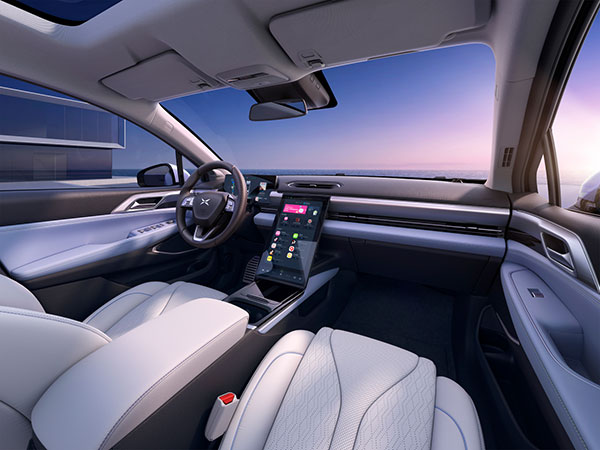
    The P5’s Xmart OS 3.0 in-car operation system supports  all-voice interaction. It uses Qualcomm’s Snapdragon SA8155P auto-grade computing platform to ensure seamless user control and interaction. The instrument console includes a 15.6-inch screen with essential information and controls where the driver needs them. Xmart OS 3.0 also allows vehicle-to-home connection.

    The P5 will be featured at Auto Shanghai 2021 on April 19.

  • Tischler Named Director of National Geospatial Program

    Michael Tischler, new director of the USGS National Geospatial Program.
    Michael Tischler, new director of the USGS National Geospatial Program.

    The United States Geological Survey (USGS) has selected Michael Tischler to be the director of the National Geospatial Program (NGP).

    Tischler begins his new post today. Tischler was most recently associate technical director of the Engineering Research and Development Center of the U.S. Army Corps of Engineers.

    The NGP provides leadership for USGS geospatial coordination, production and service activities. It engages partners to develop standards and produce consistent and accurate data through its National Map Liaisons. Operational support is provided by the National Geospatial Technical Operations Center. These and other NGP activities that are essential to the National Spatial Data Infrastructure (NSDI) are managed as a unified portfolio that benefits geospatial information users throughout the nation.

    Tischler’s accomplishments include managing the research for a $30 million broad-based research portfolio with both domestic and international applications. He has held a number of positions, from a research scientist collecting, analyzing, and processing geospatial data, to acting technical director, responsible for strategic planning and program implementation for a diverse portfolio of geospatial research projects.

    In his most recent role as associate technical director, he defined cutting-edge research projects that affect the direction of geospatial science and how geospatial data is used throughout the U.S. Army, the USGS said.

    “We are excited to have Mike to be part of the USGS mapping and geospatial community,” said Kevin Gallagher, associate director for Core Science Systems. “Mike has the background, insight, and energy to move the Program boldly into the future while still respecting the agency’s legacy for mapping excellence.”

    “Being selected to direct the National Geospatial Program is a tremendous honor, and I am both proud and humbled to join the USGS family in this role,” said Tischler. “The valuable services provided by this program are made possible by a dedicated team across the country, of which I am truly privileged to be part.”

    “The NGP has the responsibility to provide accurate, accessible, available, and authoritative geospatial data to the public and key partners while continually leveraging and adapting to evolving technologies,” Tischler continued. “I am thrilled to have the opportunity to work toward these goals alongside the talented, devoted NGP team and its partners, while engaging with the mapping community to both lead and shape the future direction of the program.”

    Tischler holds a master of science in soil and water science and a bachelor of science in soil science and is currently a Ph.D. candidate in Earth systems and geoinformation sciences at George Mason University.

    “I would also like to thank Pam Haverland for serving as the acting director for the National Geospatial Program,” Gallagher said. “Over the past six months, Pam has provided caring and visionary leadership all while completing the SES Candidate Development Program and working in the USGS Budget Office as required, at the same time. She will be sorely missed!”