Tag: NIST

  • SkyWire from Microchip makes it easier to compare clocks across locations

    SkyWire from Microchip makes it easier to compare clocks across locations

    Microchip Technology’s new SkyWire is a time measurement tool embedded in its BlueSky Firewall 2200. It’s designed to measure, align and verify time to within nanoseconds even when clocks are long distances apart. The technology enables highly scalable and precise time traceability to metrology labs to protect critical infrastructure systems.

    Network clocks are the backbone of critical infrastructure operations, with the precise alignment of clocks becoming increasingly important for data centers, power utilities, wireless and wireline networks and financial institutions.

    For critical infrastructure operators to deploy timing architectures with reliability and resiliency, their clocks and timing references must be measured and verified to an authoritative time source such as Coordinated Universal Time (UTC).

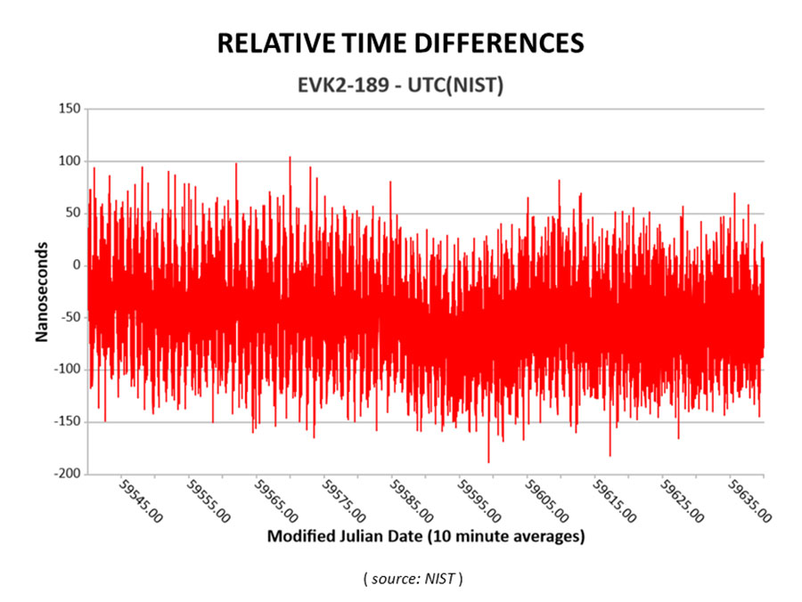
    With the BlueSky GNSS Firewall 2200 and SkyWire technology, geographically dispersed timing systems can be compared to each other and compared to the time scale systems deployed at metrology labs within nanoseconds. Measurement of clock alignment and traceability to this level has typically only been done between metrology labs and scientific institutes.

    With Microchip’s solution, critical timing networks for air traffic control, transportation, public utilities and financial services can achieve alignment within nanoseconds between its clocks to protect their infrastructure no matter where the clocks are located.

    “To ensure timing systems are delivering to stringent accuracy requirements, it’s important to measure and verify in an independent manner relative to UTC as managed by national laboratories and traceable to the Bureau International Poids et Mesures (BIPM),” said Randy Brudzinski, corporate vice president of Microchip’s frequency and timing systems business unit. “With the new SkyWire technology solution, we’re making UTC more widely accessible so that large deployments of clocks can be independently measured and verified against each other across long distances.”

    The concept originated as an extension to the National Institute of Standards and Technology’s (NIST’s) pre-existing service called Time Measurement and Analysis Service (TMAS), which is utilized by entities that are required to maintain an accurate local time standard. The BlueSky GNSS Firewall 2200 with SkyWire technology provides a commercial off-the-shelf (COTS) product to enable critical infrastructure operators to connect with the NIST TMAS Data Service for large-volume clock deployments.

    “At NIST, our goal is to enable the most accurate time to support our country’s infrastructure,” said, Andrew Novick, NIST engineer. “Our TMAS Data Service, in conjunction with commercial hardware, provides a scalable solution for anyone who needs traceable and accurate timing.” 

    Nations around the globe can replicate this solution using Microchip’s SkyWire technology capabilities within its TimePictra software suite, which delivers similar features and functionality as that provided by the NIST TMAS Data Service. Metrology labs, government agencies and enterprises worldwide can deploy TimePictra software suite and the BlueSky GNSS Firewall 2200 with SkyWire technology and have their own end-to-end solution for traceable time measurement, alignment and verification. 

    The TimePictra software suite provides customers with support to deploy BlueSky GNSS Firewalls at scale.

  • Hoptroff livestreams GNSS vulnerabilities roundtable

    Hoptroff livestreams GNSS vulnerabilities roundtable

    Hoptroff will host its thought leadership industry roundtable, “GNSS, the time is up,” on March 21. The virtual roundtable will explore the impact of escalating GNSS vulnerabilities to business continuity and how organizations can best protect business-critical operations.

    “Businesses and financial institutions need to accept and start planning how they are going to mitigate the risks associated with GNSS,” said Tim Richards, CEO at Hoptroff. “This livestream roundtable will allow business and financial institutional decision-makers to better understand the impact and disruption GNSS vulnerabilities can have on their bottom line, and why they need to act now.”

    The roundtable is an opportunity for those in the financial and business sector to learn more about the status of GPS, the growing potential risks from increased jamming, spoofing and cyberattacks, what disruption looks like, and the new technologies available to provide complementary positioning, navigation and timing (PNT) technologies to help mitigate risk.

    “GNSS vulnerabilities create serious consequences for critical infrastructure,” said Richard Hoptroff, founder and chief time officer at Hoptroff. “To effectively mitigate these threats, complementary PNT solutions need to be deployed.”

    The event will be moderated by Robert Hampshire, deputy assistant secretary for Research and Technology, U.S. Department of Transportation.

    Speakers at the roundtable event include:

    • Robert Hampshire – Deputy Assistant Secretary for Research and Technology, U.S. Department of Transportation
    • Diana Furchtgott-Roth – Heritage Foundation and George Washington University
    • Judah Levine – Fellow, National Institute of Standards and Technology (NIST)
    • Karen Van Dyke – Director for PNT, U.S. Department of Transportation
    • Steve Suarez – Global Head of Innovation, Financial Services
    • Kathryn Condello – Senior Director, National Security/ Emergency Preparedness, Lumen Technologies
    • Richard Hoptroff – Founder and Chief Time Officer, Hoptroff

    Areas of discussion at the roundtable include:

    • The rising GNSS vulnerabilities and the potential consequences of GNSS disruption such as service outages, errors, or inaccuracies.
    • Example use cases where GNSS vulnerabilities can have a significant impact on your business continuity.
    • How to enable new resilient complementary technologies for your disaster recovery plans.
    • How to start utilizing these technologies today in your real-life applications such as precision timing for global financial services.
    • Practical advice for businesses on reducing GNSS risk in financial transactions, fraud detection, compliance and data integrity.

    Those interested in attending the livestream roundtable can sign up on the Hoptroff website.

  • The billon-dollar-a-day GPS mistake?

    The billon-dollar-a-day GPS mistake?

    We all need to be careful that the numbers we are throwing around to support our case aren’t really undermining it.

    Headshot: Dana Goward
    Dana Goward, President, Resilient PNT Foundation

    Over the last several weeks, I have repeatedly heard government officials and others talking about the value of GPS to the U.S. economy.

    In each case they cited a 2019 report sponsored by the National Institute of Standards and Technology. It determined that, if GPS services were to go away, the U.S. economy would lose one billion dollars a day.

    A billion dollars is a lot of money.

    Yet the U.S. annual gross domestic product is more than $22 trillion a year. That’s more than $60B a day. One billion dollars is less than 1.7%.

    That just doesn’t seem right.


    A member of the White House’s National Security Council said “GPS is still a single point of failure” for America. That sounds like a pretty big hit to the economy. Not to mention our national security.


    GPS signals are critical for networks, transportation, communications, power grid operations, first responders…virtually every critical infrastructure. If they go away, the U.S. GDP will certainly suffer much more loss than 1.7%. The economy would likely go from growing to shrinking and continue that way for quite a while.

    I don’t know exactly how much the U.S. will suffer if GPS suddenly goes away, but I am sure it will be a lot. Texas alone lost an estimated $195 billion with at least 57 dead as a result of its February 2021 week-long power crisis. Although not caused by a GPS outage, the number gives us real-world benchmarks for the impacts of a major tech infrastructure failure.

    If GPS fails, there will certainly be more accidents while people across the nation get used to it not being available. First responders will have a much harder time getting places and using land mobile radios. All kinds of essential services will be disrupted. More people will die than would have been the case otherwise.

    In December 2021, a member of the White House’s National Security Council said “GPS is still a single point of failure” for America. That sounds like a pretty big hit to the economy. Not to mention our national security.

    Pinpoint book coverIn his book “Pinpoint – How GPS is Changing Technology, Culture and Our Minds,” author Greg Milner asks about the value of GPS. His answer is another question. “What’s the value of oxygen?”

    The authors of the NIST-sponsored study were undoubtedly diligent. But they were faced with an impossible task – to quantify the unquantifiable. And like any analysis, they were limited in what they could do by the available time, money, and hard data. They were asked for a number. They delivered one that could be easily supported.

    A billion dollars is a lot of money. It might be a fairly impressive sound bite for general audiences.

    Government budget analysts and policy makers, though, are accustomed to dealing with dollars in the hundreds of billions and trillions. A billion a day, while not chump change, is not a major issue.

    Protecting GPS and ensuring the nation has resilient positioning, navigation and timing services are major issues.

    We all need to be careful that the numbers we are throwing around to support our case aren’t really undermining it.


    Dana A. Goward is president of the Resilient Navigation and Timing Foundation.

  • Satelles and NIST team up on precision timing

    Satelles and NIST team up on precision timing

    Cooperative agreement expands precision timing distribution options for critical infrastructure and verifies STL’s agreement with UTC via UTC(NIST)

    This March 30, 2022, chart of Satelles and NIST testing verifies that STL timing agrees with UTC. (Chart: Satelles)
    This March 30, 2022, chart of Satelles and NIST testing verifies that STL timing agrees with UTC. (Chart: Satelles)

    Satelles Inc., provider of highly secure satellite-based time and location services, has entered a cooperative agreement with the U.S. National Institute of Standards and Technology that directly connects STL’s operational infrastructure to the source of UTC(NIST), the national standard for time and frequency in the United States produced in coordination with the U.S. Naval Observatory.

    The agreement calls for Satelles to provide its STL service to NIST. Reciprocally, the agreement includes the introduction of a connection between an STL Ground Monitoring Station (GMS) provided by Satelles to the NIST collection of extremely accurate atomic clocks that maintains the official time scale for UTC(NIST).

    The Cooperative Agreement was described in NIST Technical Note 2187, “A Resilient Architecture for the Realization and Distribution of Coordinated Universal Time to Critical Infrastructure Systems in the United States,” published in November 2021.

    In February 2021, Satelles delivered and configured an STL GMS at NIST’s Time and Frequency Division in Boulder, Colorado. This facility is home to the ensemble of high-precision cesium beam and hydrogen maser atomic clocks that maintains UTC(NIST).

    After conducting a series of successful preliminary tests in the spring of 2021, NIST then directly connected the STL GMS to its primary clock ensemble in June 2021. Comparing timing provided by STL to UTC(NIST), the testing confirmed STL’s long-term stability of better than 25 nanoseconds with short-term time deviation of 50 nanoseconds.

    STL from Satelles is a resilient, alternative PNT service from low-Earth-orbit (LEO) satellites that enterprise customers rely on as a primary timing source. Telecom operators, for example, use STL for 5G wireless network deployments where GPS is unavailable indoors or when other timing solutions cannot provide the required level of accuracy.

    STL’s agreement with UTC also is important for critical infrastructure and other applications that require an essential contingency capability to protect the operations of PNT-dependent systems and ensure survivability and resilience.

    “Satelles has a network of GMS nodes positioned around the world to receive STL signals and calculate the position and timing of the satellites for purposes of producing timing corrections, and
    now we are fortunate to have a GMS connected inside NIST’s main time lab,” said Gregory Gutt, president and CTO of Satelles. “It’s an honor to be given direct access to UTC(NIST), especially in an arrangement that delivers benefit to both our customers and NIST.”

    Visit satelles.com/nist for more information about NIST reports that detail the performance of STL and collaborations between Satelles and NIST.

  • ColdQuanta to develop atomic clocks for Office of Naval Research

    ColdQuanta to develop atomic clocks for Office of Naval Research

    Image: agsandrew/iStock/Getty Images Plus/Getty Images
    Image: agsandrew/iStock/Getty Images Plus/Getty Images

    Next generation of atomic clocks to provide improved performance, stability and durability for U.S. Department of Defense

    ColdQuanta has been awarded a 5-year subcontract to develop portable atomic clocks for the Office of Naval Research. ColdQuanta will serve as a subcontractor to Vescent Photonics, which secured the $15.6 million total award.

    Under the Compact Rubidium Optical Clock (CROC) program, ColdQuanta will provide the physics package with development inputs from the Atomic Devices and Instrumentation Group at the National Institute of Standards and Technology (NIST). The program began in November 2021 and will span three phases through 2026.

    As part of the CROC program, ColdQuanta and its partners will design, build and deliver a new generation of high-performance atomic clocks ready for field deployment at a high technology readiness level (TRL). Specifically, the program will interrogate a two-photon optical clock transition in a warm vapor of rubidium atoms to achieve improved stability and performance. The clocks will also offer reduced size, weight and power consumption.

    ColdQuanta is participating in the project alongside Vescent, which will provide optical frequency comb technology, and Octave Photonics and the Quantum Nanophotonics Group at NIST, which will supply crucial advances in non-linear nanophotonics. The outcome of the program will be 10 prototype field-deployable optical clocks at or above TRL 6 that exhibit long-term instability to better than three parts in 100 trillion and offer >50% reduction in power consumption.

    The CROC program will be conducted in three phases:

    • Phase 1: All critical technology elements advanced to TRL 6 and demonstrated in a modular clock.
    • Phase 2: Engineering and verification efforts to integrate the individual components into prototype clocks.
    • Phase 3: Manufacturing 10 final prototype clocks for ONR evaluation in relevant platforms.
  • TRX awarded NIST funding for NEON Personnel Tracker

    TRX awarded NIST funding for NEON Personnel Tracker

    TRX Systems was awarded funding through the National Institute of Standards and Technology (NIST) Public Safety Innovation Accelerator Program (PSIAP) to test, validate and harden the TRX NEON Personnel Tracker solution to support wide-scale public safety deployment. TRX is partnering with the Arlington County Fire Department (ACFD) to conduct extended testing during which the TRX 3D location technology will be used by all personnel at Station 5, serving Pentagon City and Crystal City, to validate usability and performance and to better align the solution with first responder needs.

    Through a previous NIST PSIAP award, TRX improved the accuracy and capabilities of its NEON Personnel Tracker solution. With this subsequent Technical and Business Assistance (TABA) award, TRX will take the next steps toward wide-scale deployment by validating and tuning the NEON solution in a challenging live environment. Combined, these projects aim to accelerate the availability of improved 3D location accuracy, easy to use 3D map data tools, and actionable 3D visualizations for first responder use cases.

    Over the course of this program, TRX will partner with ACFD to conduct an 8-month field trial that exercises the TRX NEON Personnel Tracker solution 24 hours a day, 7 days a week in a fully operational environment. The key objectives of this extended deployment are to identify and close any gaps that could inhibit widescale deployment, validate usability and tracking accuracy, and demonstrate the operational feasibility and value of the solution.

    First responders typically operate in environments that are indoors, underground, or in other areas where reliable access to GPS signals is impeded. TRX’s NEON Personnel Tracker system delivers reliable and real-time 3D location in these GPS-denied environments by using patented mapping and tracking algorithms that fuse inertial sensor data to compute the user’s path and position. This solution lets on-scene and remote commanders track the real-time location of personnel during an incident, helping them to ensure the safety of their teams and improve the efficiency of their response.

  • NIST confirms STL as reliable timing source, even indoors

    NIST confirms STL as reliable timing source, even indoors

    Study by U.S. government agency responsible for maintaining national time scale shows that Satelles provides a signal that is independent of GNSS and delivers exceptional timing stability

    Following a detailed performance study in 2020, the U.S. National Institute of Standards and Technology (NIST) determined that Satellite Time and Location (STL) is a reliable source of timing highly consistent with Coordinated Universal Time (UTC). The secure STL services are provided by Satelles Inc.

    STL is based on a signal independent from GPS and other GNSS. The STL service was able to deliver this consistent performance in a deep indoor environment where GNSS signals did not reach.

    The results of the study were shared by Elizabeth Donley, chief of the Time and Frequency Division at NIST, in a keynote speech at the Workshop on Synchronization and Timing Systems (WSTS) conference on April 1.

    Donley articulated the details of the NIST study, in which a GPS-disciplined clock and a Satelles EVK-2 evaluation unit with a quartz oscillator were compared to UTC for 50 days. In this evaluation, the GPS device received its signal from an outdoor antenna, whereas the Satelles device was connected to an indoor antenna in a deep indoor environment where GNSS signals were not able to reach.

    Time deviation calculations estimated the stability of the two signals with respect to the UTC time scale. Based on one day of averaging, the GPS instability was less than two nanoseconds, and the STL instability was only slightly higher at under three nanoseconds (see chart). These measurements demonstrated that STL delivers stability comparable to GNSS and does so in an indoor location where GPS signals usually cannot penetrate.

    Image: NIST
    Image: NIST

    STL delivers a positioning, navigation and timing (PNT) service from satellites in low Earth orbit (LEO) to back up or augment GPS and other GNSS. The evaluation by NIST confirms that users of PNT-reliant applications can obtain accurate and reliable timing without using GNSS.

    “We are thrilled that NIST has performed these independent tests that confirm what we have long known, which is that STL delivers an independent timing source that is reliable and highly consistent with UTC,” said Gregory Gutt, president and CTO of Satelles. “This report complements and reinforces the findings of the U.S. Department of Transportation, which identified STL as a top-ranked PNT system in its technology demonstration report released earlier this year, and showed STL to be the only solution that demonstrated a wide-area timing capability that works indoors and out.”

  • Orolia schedules ‘Coffee Talk’ on PNT Executive Order

    Orolia schedules ‘Coffee Talk’ on PNT Executive Order

    Orolia logoTo mark the one-year anniversary of the PNT Executive Order, Orolia will host an interactive Coffee Talk webinar on March 24 to explore the latest developments in the national initiative to protect U.S. critical infrastructure from GPS/GNSS jamming, spoofing and interference.

    Panelists from the U.S. Department of Homeland Security (DHS) and the National Institute of Standards and Technology (NIST), among others, will focus on key actions and priorities for 2021 and beyond, including insights and context on recently published works such as the NIST Foundational PNT Profile issued on Feb. 11, 2021, and the DHS Conformance Framework of Dec. 18, 2020.

    Critical infrastructure and PNT industry panelists will also share their perspectives on practical ways to increase resiliency and key factors to consider, in view of the latest Executive Order guidance.

    More information about Resilient PNT and GNSS jamming/spoofing is available in Orolia’s online resource center.

    Panelists include:

    • Ernest Wong, Technical Manager, Science and Technology Directorate, DHS
    • Jim McCarthy, Senior Security Engineer, National CyberSecurity Center of Excellence,  NIST
    • Ya-Shian Li-Baboud, Computer Scientist, Cyber Infrastructure Group, NIST

    Register here for the Coffee Talk “PNT Executive Order Update: 2021 Actions and Priorities,” 11 a.m. EDT, March 24. Use the registration form to share questions or comments on what to discuss.


    Feature photo: E4C/E+/Getty Images

  • NIST cybersecurity profile designed  to safeguard critical infrastructure

    NIST cybersecurity profile designed to safeguard critical infrastructure

    NIST's new cybersecurity profile is designed to help mitigate risks to systems that use PNT data, including finance, transportation, energy and other critical infrastructure. While its scope does not include ground- or space-based PNT source signal generators and providers (such as satellites), the profile still covers a wide swath of technologies. (Image: B. Hayes/NIST)
    NIST’s new cybersecurity profile is designed to help mitigate risks to systems that use PNT data, including finance, transportation, energy and other critical infrastructure. While its scope does not include ground- or space-based PNT source signal generators and providers (such as satellites), the profile still covers a wide swath of technologies. (Image: B. Hayes/NIST)

    The National Institute of Standards and Technology (NIST) has drafted guidelines for applying its Cybersecurity Framework to critical technologies such as GPS that use positioning, navigation and timing (PNT) data. Part of a larger NIST effort to safeguard systems that rely on PNT data, these cybersecurity guidelines accompany NIST efforts to provide and test a resilient timekeeping signal that is independent of GPS.

    Formally titled the “Cybersecurity Profile for the Responsible Use of Positioning, Navigation and Timing (PNT) Services (NISTIR 8323),” the new guidelines are designed to help mitigate cybersecurity risks that endanger systems important to national and economic security, including those that underpin modern finance, transportation, energy and additional economic sectors.

    The draft profile is part of NIST’s response to the Feb. 12, 2020, Executive Order on PNT. In early 2020, NIST sought public input regarding the general use of PNT data. The PNT profile will join the growing list of profiles created to help apply the NIST Cybersecurity Framework to particular economic sectors, such as manufacturing, the power grid and the maritime industry. The scope of the profile includes any system, network or other asset that uses PNT services, including systems that receive and rebroadcast PNT data.

    While its scope does not include ground- or space-based source PNT signal generators and providers (such as satellites), the profile still covers a wide swath of technologies. Partly for this reason, NIST’s Jim McCarthy said that it is intended to be a foundational set of guidelines that PNT users can customize.

    “The profile is meant to help a broad set of users address their cybersecurity needs,” said McCarthy, one of the draft’s authors. “Rather than focus on a single economic sector, we designed it to apply to all users of PNT. Agencies and companies can tailor it to their needs based on their particular cybersecurity risk and other sector-specific factors.”

    As directed by the Executive Order, the profile can help organizations accomplish four tasks:

    • identify systems that use PNT data, and/or that propagate this data based on a source signal
    • identify PNT data sources, such as a GPS signal
    • detect disturbance to and manipulation of systems that use PNT services
    • manage the risks that come with responsible use of these PNT services

    “Our premise is that there are organizations that may not realize they are using PNT data, or know how they are using it,” McCarthy said. “Part of our goal is to help them make these connections so they can protect their operations more effectively.”

    The Executive Order also delegates to the Department of Commerce the critical task of providing a source of Coordinated Universal Time (UTC) that is independent of GPS. To this end, NIST also recently conducted initial tests of a special calibration service for companies, utilities or other organizations that wish to receive NIST’s version of the global time standard, UTC(NIST), through commercial fiber-optic cable.

    The service aims to provide a time reference directly traceable to UTC(NIST) with an accuracy of 1 microsecond — good enough for telecom networks, the power grid and financial markets, and thereby boosting the resilience of accurate time distribution and the infrastructure sectors and subsectors that use timing services.

    The initial link is a collaboration between NIST and OPNT, a commercial time-service provider based in Amsterdam, the Netherlands. While the work was led by researchers at NIST’s Boulder, Colorado, campus, the dedicated optical fiber connects the reference time scale at NIST headquarters in Gaithersburg, Maryland, to a facility in McLean, Virginia, that will ultimately serve as the hub for East Coast distribution of timing data.

    OPNT has extended the initial fiber link to Atlanta, Georgia, about 800 kilometers from McLean. Preliminary data suggest that this link will be able to support the requirements of the Executive Order.

  • Orolia selected for NIST workshop on PNT profile development

    Orolia selected for NIST workshop on PNT profile development

    Photo: Orolia
    John Fischer. (Photo: Orolia)

    John Fischer, vice president of advanced R&D at Orolia, will join three industry leaders as a panelist in a National Institute of Standards and Technology (NIST) workshop about the federal government’s PNT Executive Order. Fischer is a member of GPS World’s Editorial Advisory Board.

    Other workshop panelists include Michael Calabro, chief engineer at Booz Allen Hamilton; Michael J. Lewis, senior staff security strategist at Chevron; and Gerardo Trevino, technical leader in cyber security at the Electric Power Research Institute. The workshop will take place Sept. 15-16.

    The PNT Executive Order requires the development of positioning, navigation and timing (PNT) profiles to ensure that the nation’s critical infrastructure is resilient to disruptions or denial of service attacks on GPS signals and PNT data, Orolia said.

    NIST, the organization hosting the workshop, is working to provide a ybersecurity framework-based profile to promote the responsible use of PNT services and help critical infrastructure owners make risk-informed decisions to protect their systems.

    NIST is also seeking feedback on the Cybersecurity Profile for the Responsible User of Positioning, Navigation, and Timing (PNT) Services Draft Annotated Outline, which can be viewed here.

    Register for the workshop here. Registration closes Sept. 11.

  • PNT Executive Order helpful, but delays market solutions

    PNT Executive Order helpful, but delays market solutions

    Headshot: Dana Goward
    Dana Goward, President, Resilient PNT Foundation

    On Feb. 12, the White House released an “Executive Order on Strengthening National Resilience through Responsible Use of Positioning, Navigation, and Timing Services.”

    It is gratifying to see White House attention to this issue. The increase in public awareness it brings will benefit individual users and the nation as a whole.

    The order also hints at market driven solutions that could quickly improve America’s PNT resilience.

    Needless delays

    Unfortunately, the order fails to direct immediate action on this critical national and economic security issue. Instead it needlessly pushes most action and responsibility off for a year or more to do “more study.”

    This is hard to understand as most of the “more study” has already been completed. For example, the order tells the Department of Commerce to take up to a year to examine PNT use in various sectors, and identify vulnerabilities and user needs. The Department of Homeland Security has already completed a National Risk Assessment and, according to congressional staff, has recently completed a report on user requirements mandated in 2017’s National Defense Authorization Act.

    The Office of Science and Technology Policy is given a year to develop a plan to test robust and resilient non-GNSS PNT services (but is not required to actually do any testing). Congress mandated such a test program in 2017 and funded it with $10 million in 2018. After much delay, the Department of Transportation will complete the testing in May of this year.

    The order gives the Department of Commerce six months to make available a time source to support critical infrastructure. For more than 60 years, the nation’s master clock has been available to users at the department’s NIST Laboratory in Boulder, Colorado.

    Note the challenge has not been the clock, but that the nation has no way — other than vulnerable GPS signals — to distribute time at the needed level of accuracy to millions of critical infrastructure nodes. Government studies in 2007 and 2014 determined that the best way to do this was with a ground-based system. The Department of Transportation’s ongoing testing program is examining this issue again.

    Market-driven solutions

    Aside from increasing public awareness, the best thing the Executive Order does is to point a way forward for market-driven resilient PNT solutions.

    The order calls for federal contracts to (in 21 months, if everyone does their jobs on time) require that vendors use existing and new resilient PNT sources.

    If this eventually happens, the government could leverage its enormous influence in the market and stimulate creation of one or more commercial distribution systems for resilient, non-GNSS PNT. This is a great concept, and very much in keeping with America’s tradition of letting market forces solve some of its biggest problems.

    But this solution will not spring into life on its own.

    No commercial entity will invest tens of millions of dollars, or more, in a PNT system without assurance in advance of an income stream. Especially since federal contracting officers can and will waive the requirement if offerors cannot reasonably meet it.

    If stimulating a market solution is the administration’s intent, it must stay actively involved and encourage the process for some time to come.

    This includes complying with the 2018 law that requires establishment of at least one wireless, terrestrial, difficult-to-disrupt source to back up the timing signals provided by GPS.

    Fortunately, this can be done by leveraging the free market at minimal cost and with little administrative effort.

    By contracting to subscribe to a commercial service that will provide resilient PNT signals, the government need only invest a relatively small yearly sum using a fairly simple contract vehicle. Such a contracting technique has been used before with great success.

    In 2007 the Federal Aviation Administration (FAA) did this as a way to establish its ADS-B aviation tracking and safety network. Once the subscription contract was let, the commercial provider was able to get financing and quickly build out the system.

    Today, the FAA gets the information it needs, doesn’t have the headache of owning and maintaining a large network, and even shares in the revenue the system owner earns from selling data to other companies.

    Additional leadership needed

    It is important to remember that, regardless of the issue, presidential pronouncements are not enough.

    In 2004, President G.W. Bush directed a number of actions to protect the nation’s critical PNT, including establishment of a GPS backup capability. While 16 years later his directive is still official executive branch policy, that mandate and many others from his order are still unexecuted.

    Real improvements to PNT resilience and our nation’s security depend not on one-time pronouncements, but continued leadership focus and engagement.

    This is always a challenge for initiatives driven by the White House. It will be doubly so in this case as there is no clear department leader for civil PNT issues the administration can rely on while it attends to the next issue of the day.

  • OGC calls for proposals for Indoor Mapping and Navigation Pilot Initiative

    The Open Geospatial Consortium (OGC) has released a call for participation to solicit proposals for the its Indoor Mapping and Navigation Pilot Initiative.

    According to OGC, the Indoor Mapping and Navigation Pilot Initiative, sponsored by the Public Safety Communications Research Division of the National Institute of Standards and Technology (NIST), will create and advance solutions to complex geospatial challenges related to indoor mapping and navigation for first responders.

    First responders typically survey high-risk facilities in their jurisdiction at least once per year as part of a preplanning process. The preplanning process can be time-consuming and inefficient, according to OGC, so the Public Safety Communications Research Division of the NIST Communications Technology Laboratory has identified mobile 3D light detection and ranging (lidar) as a potentially transformational technology for first responders. Using lidar and 360-degree camera imagery coupled with advanced software processing, first responders could efficiently capture 3D point clouds and a wealth of other information, both observed and derived, while walking through buildings as part of their routine preplanning operations, OGC said.

    In addition to creating point clouds for visualization and mapping, 3D lidar can be used in localization, object classification, integration with virtual/augmented reality solutions, change detection and more. OGC’s Pilot Initiative will call upon a diverse array of leading organizations in the field and leverage standardized, open GIS frameworks, data models and data exchange formats to stimulate the rapid generation of prototypes and demonstrations for these activities.

    According to OGC, best practices and lessons learned from the Pilot Initiative shall be captured in engineering reports or other means and, where appropriate, forwarded to the respective standards committees under the OGC and International Standards Organization for consideration.

    Participation is only open to OGC members; however, proposals from non-members will be considered provided that a completed application for OGC membership (or a letter of intent to become a member) is submitted prior to (or with) the proposal.