The Federal Aviation Administration on Jan. 16 issued a warning to pilots to “exercise caution” when flying over the Pacific Ocean in parts of Latin America due to potential military activities. Areas cited include the eastern Pacific Ocean near Mexico, Central America and parts of South America.
A series of Notices to Airmen (NOTAMs) issued by the FAA state, “Potential risks exist for aircraft at all altitudes, including during overflight and the arrival and departure phases of flight.” The alerts are in effect for 60 days. NOTAMs are issued routinely in any region where there are hostilities nearby.
Photo: iStock.com/NiseriN via the Federal Aviation Administration
In cooperation with the U.S. Department of Defense (DoD), the Federal Aviation Administration (FAA) is establishing restrictions on drone flights up to 400 feet within the lateral boundaries of National Geospatial-Intelligence Agency (NGA) facilities.
The temporary flight restrictions — specific to unmanned aircraft systems (UAS) — apply to three NGA facilities in or near St. Louis:
National Geospatial-Intelligence Agency (NGA) West
NGA Next West
NGA Arnold
In June, the FAA responded to federal agency requests and restricted drone operations over penitentiaries and Coast Guard bases.
The Federal Aviation Administration (FAA) is using its existing authority under Title 14 of the Code of Federal Regulations § 99.7 — “Special Security Instructions” — to address concerns about drone operations over national security-sensitive facilities.
The changes, which are highlighted by FAA NOTAM FDC 8/7350, are pending until they become effective on Aug. 30.
Only a few exceptions permit drone flights within these restrictions, and they must be coordinated with the individual facility and/or the FAA.
Operators who violate the flight restrictions may be subject to enforcement action, including potential civil penalties and criminal charges.
To ensure the public is aware of restricted locations, the FAA website also provides an interactive map, downloadable geospatial data and other important details. The restrictions also are depicted in the FAA’s B4UFLY mobile app. Broader information regarding flying drones in the National Airspace System, including frequently asked questions, is available on the FAA’s UAS website.
The FAA continues to consider additional requests by eligible federal security agencies for UAS-specific flight restrictions using the agency’s § 99.7 authority as they are received. Additional changes to these restrictions will be announced by the FAA as appropriate.
U.S. Department of Defense interference events, designed for training in GPS-denied environments, also can affect civilian aircraft.
In April 2016, a business jet lost all GPS signals because of an interference event and was forced to enter a Dutch Roll, resulting in an emergency descent.
Pilots and air traffic controllers in the National Airspace System want to better understand the operational impacts of the intentional interference, which has risen from 43 in 2012 to 127 in 2017.
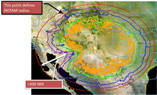
Interference Contours from the YPG 17-02 GPS interference event in January 2017. (Source: FAA)
An RTCA Tactical Operations Committee composed of Federal Aviation Administration (FAA) and industry experts in March issued a report with recommendations to change the current Notices to Airmen (NOTAMs).
Along with a description of the event, NOTAMs show contours that represent an area outside of which operators should expect no interference impact. Both operators and the FAA agree that most aircraft experience no interference impact even inside the contours.
Operators recommend that the FAA provide pilots and controllers improved understanding of where to expect interference impacts based on different equipment capabilities, so that operators could integrate such information in their flight planning processes.
Impact varies widely, depending on aircraft, avionics, position, time, location and terrain. Effects could include complete loss of GPS navigation, position errors, loss of ADS-B or impact to GPS-dependent systems.
Operators are encouraging thte FAA to conduct outreach with civil aviation stakeholders around significant interference events so they better understand the impact.
The FAA says it is studying the committee’s 25 recommendations.