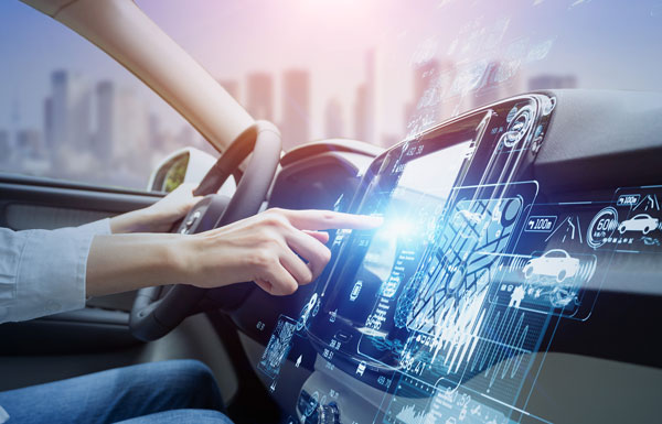
California lawmakers have passed a bill prohibiting OEMs of autonomous vehicles from marketing their vehicles as ‘fully self-driving.’ This law went into effect Jan. 1.
This legislation was passed in mid-September of 2022 and states that manufacturers are prohibited from selling new passenger vehicles with autonomous driving features without fully disclosing their capabilities and limitations. Companies such as Tesla, and other OEMs in California, will no longer be able to market vehicles as ‘fully autonomous,’ as the new bill states that it is “considered a misleading advertisement.”
Any violation of the new legislation will be punished as an infraction. Based on this, it is unclear what the exact punishment will be for OEMs that violate this policy.
Senate Bill No. 1398 will be added to Section 24011.5 of California’s vehicle code. The full bill can be found here.
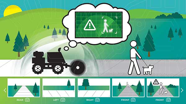
New BOLT platform enables equipment manufacturers to automate outdoor jobs, adding autonomous navigation, connected sensors and real-time operations to machines.
Left Hand Robotics, a manufacturer of self-driving smart robots for commercial turf and snow, has launched BOLT, a technology platform that transforms outdoor machinery and power equipment into smarter, more efficient, ready-to-work robots.
BOLT brings autonomous navigation, connected sensors, and real-time robot operations to outdoor power equipment and machines doing repetitive jobs across the globe. Building on Left Hand Robotics’ field-proven experience with its own robot tractors, BOLT allows OEMs to launch faster, reduce R&D costs, and tap into a unified platform with navigation, sensors, controls, software and apps.
BOLT focuses on several key areas to help with machine automation, including:
autonomous navigation and telemetry
smart sensors and cameras
connected power equipment and controls
cloud-based robot operations center and apps
job planning, reporting and analysis
Because each OEM is likely to have different requirements or product needs, BOLT partners go through multiple deployment phases, including evaluation, development and deployment.
Partnering with OEMs. Left Hand Robotics soft-launched BOLT earlier this year and interest has been high from manufacturers needing more automation capabilities. The company is now collaborating with power equipment and machine manufacturers to incorporate BOLT features into their future product lines.
“Our team has learned a lot, building, testing, proving how autonomous tractors can work on tedious, dirty jobs in the real world. These are tough problems to solve and we have already invested more than 80 engineering years into the technology behind BOLT,” said Terry Olkin, CEO for Left Hand Robotics. “We’ll continue to build our own robots while offering BOLT to a limited number of OEMs in the first year.”
The importance of sensors, whether they be incorporated in cute dog robots or autonomous vehicles, is gaining more traction.
At September’s Custom Electronic Design and Installation Association (CEDIA) Expo, Sony Electronics President and COO Mike Fasulo told GPS World that its foundation sensors are going into autonomous vehicles, drones, agricultural solutions and other platforms.
“A lot of people also don’t know that more than half of the hardware in most smartphones is ours,” Fasulo said. “These sensors we are working on do things you and I can’t do. They can assess sunlight and darkness. They can put a safety cocoon around a vehicle.”
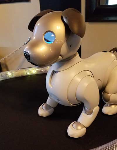
The Aibo robot dog uses artificial intelligence to mimic a real puppy’s behavior. (Photo: Kevin Dennehy)
At the conference, Sony displayed a nearly $3,000 Aibo dog robot, which has many of the same sensors that go into many of the company’s other products, including its venerable camera line. Aibo has facial recognition technology and uses artificial intelligence to mimic a real puppy’s behavior.
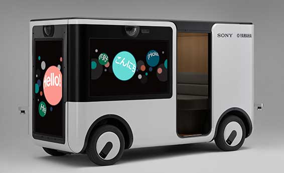
Sony sensors seem to be a cornerstone in several new announcements. Less than two months ago, Sony and Yamaha Motor Co. announced the joint development of the SC-1 Sociable Cart, a small autonomous vehicle that will be deployed to golf courses, amusement parks and commercial facilities, the company said.
The SC-1, which is not for sale, features five seats, replaceable batteries, front and rear scope of view thanks to image sensors, an innovative vehicle design, and other improvements over an original prototype vehicle.
In addition to the image sensors, the vehicle has ultrasonic sensors and a two-dimensional laser detection and ranging (lidar) system, the company said. These sensors allow the vehicle to gather cloud travel data for safe-driving analysis.
Sony is working with Japan’s NTT Docomo to test the vehicle’s 5G mobile technologies for remote-controlled functions, the company said.
Geotab leverages sensor data
Sony and Yamaha Motor plan to roll out the SC-1 later this year in Japan. (Photo: Sony/Yamaha Motor)
Canada-based Geotab has made big announcements this year, although the huge one is from the U.S. government to equip more than 200,000 vehicles with its telematics systems.
While that contract itself is massive, the company believes the more than 2 billion data points gathered each day, from millions of Geotab-equipped vehicles on the road, is the real valuable commodity.
The data gathered with the company’s connected-car technology can help companies and governments assess how their fleets are operating, said Mike Branch, Geotab vice president of data and analytics.
Branch, who leads a team of 40 employees, said the company uses the data to help cities assess road impediments — not only road quality. This includes analyzing ABS activation to look at black ice or other hazards. “While weather companies can only estimate conditions, we have sensors in vehicles that can give hyperlocal reports and ground truth,” he said. “People consistently slamming on their brakes in one area is an example [of aggregative data].”
Back in the day, which is less than 10 years ago, all that many companies expected from their fleet management systems was to let them know where their drivers were, by using GNSS and mapping technology. Today, the sensors — and data provided by them — allow managers to assess dangerous driving areas, save on fuel costs by rerouting trucks and compare routes throughout the United States, not just in big cities, Branch said.
In the smart cities space, Branch said that Geotab is working with municipalities for fuel intersection insight mapping. “This means if 20 vehicles, or even just two, are stopped at an intersection, our sensors can detect the wait times,” he said. “The big thing for us is looking at this smart-city deployment to leverage organic data in a private manner.”
Because of the nature of data procurement, privacy is big topic for the company, Branch said. “We treat it with high importance. Our view is that the data is owned by the customer,” he said. “They have full access to it. We will go through it, aggregately, so we can improve our customer’s experience.”
Keeping OBD port secure
The future of open on-board diagnostic (OBD) vehicles — and procuring secured and open data from them — is a concern for Geotab, Branch said.
“We have a full port safety committee with the goal of security and access to the port,” he said. “We believe in open access to this port. This gets to be a concern with mixed-fleet Fords, Mercedes, BMW and others as the data can slow down the port at any time.”
Branch said the company does not want to remove the entrepreneur, who is interested in working with the port in a safe manner. “We work with the OEMs on the future of telematics not just by pulling the data from our device, but pulling it from their feed,” he said.
Branch said that technology may make the port dongle obsolete in five to 10 years, but until then, the company has created an ecosystem to enable the use of the data. “There is going to be an aftermarket as cars are lasting an average of 11 years,” he said.
Friday is the deadline for GPS manufacturers to apply to test their equipment at a special event with live-sky test scenarios focused on spoofed GPS signals.
The Department of Homeland Security (DHS) Science and Technology Directorate (S&T) is offering an opportunity for manufacturers of GPS equipment used in critical infrastructure to test their products against GPS jamming and spoofing.
The GPS Testing for Critical Infrastructure (GET-CI) event, set for April 17-21 at the Muscatatuck Urban Training Center in Butlerville, Indiana, is the first in a series of test opportunities.
“Accurate and precise position, navigation, and timing (PNT) information is vital to the nation’s critical infrastructure,” said Robert Griffin, acting DHS under secretary for Science and Technology. “S&T has established this program to assess GPS vulnerabilities, advance research and development, and to enhance outreach and engagement with industry. The objective is to improve the security and resiliency of critical infrastructure.”
The GET-CI events provide industry an opportunity to test GPS equipment in unique live-sky environments. For the April event, DHS S&T will be creating live-sky test scenarios focused on spoofed GPS signals.
DHS S&T invites manufacturers of commercial GPS receivers and equipment used in critical infrastructure to submit applications for participation. For submission instructions and further information, see the Request for Information for Participation (RFIP) announcement on FedBizOpps.
Interested organizations should submit their applications for participation by March 3.
Email [email protected] with questions about the event and how to participate.
Recent progress with Dedicated Short Range Communications (DSRC) Notice of Proposed Rule Making (NPRM) brings connected cars or V2X — connectivity between vehicles, infrastructure and all road users — closer to reality than ever before. If all goes well, an NHTSA mandate on DSRC in new light vehicles is expected to start around 2020 as a phase-in plan, with completion around 2025.
Regulations for aftermarket devices are expected to come soon after. The mandate is expected to leave auto OEMs to choose the applications and human-machine interface (HMI). This will be the culmination of more than a decade of technology development and standardization by U.S. Department of Transportation (USDOT), automotive OEMs and other industry partners.
Significance of V2X. According to USDOT, V2X technology can positively impact more than 80% of non-impaired vehicle crash types that result in over 30,000 deaths in the U.S. alone. A report by the Federal Highway Administration to Congress states that V2X technology is ready to be deployed in the near future and is expected to yield significant safety and efficiency benefits.
From a consumer’s perspective, V2X will be a part of a vehicle ADAS (Active Safety Driver Assistance System). Initial systems will provide information only, and these systems are expected to evolve into warning and control capabilities. In a future vehicle, information from multiple sensors including V2X will be combined/fused to generate a view of the surrounding environment. Figure 1 gives an example of such sensors including long- and short-range radar, lidar, cameras and V2X. V2X offers unique advantages over other sensors that depend on direct line-of-sight. Information can be received from vehicles not visible to other sensors, giving a much larger field of view. V2X can transmit information directly from traffic control devices, instead of inferring information from camera observations.
Figure 1. Example of a vehicle sensor configuration.
Figure 2 depicts the sensor fusion screen from an ADAS development platform by Renesas Electronics America. Such a platform offers the flexibility to implement an ADAS using all available sensors, for example blind-spot warning from radar, forward collision warnings from combined radar, camera and V2X, surround object detection from combined radar, lidar, vision and V2X, with information presented via an OEM-specific HMI.
Figure 2. Renesas ADAS development platform.
GNSS role and challenges
V2X is built on the assumption that vehicles, infrastructure elements, and other road users are location-aware and can communicate critical information to others around them. As seen in Figure 3, the system will position all communicating V2X entities with respect to the host vehicle and security interface, which validates all relevant DSRC messages. A control area network (CAN) or a similar interface will be needed for direct access to vehicle information such as brake and turn-light status and odometer. Interfaces to long-range connectivity such as cellular networks and other data sources such as maps may also be included. The system will connect to an HMI to display information, and future systems will likely evolve to vehicle control functions.
Figure 3. Components of a V2X system.
Looking at the components of an over-the-air (OTA) V2X basic safety message (BSM), this includes a UTC-based time marker, WGS84-based position, and an estimated position error — all critical data that primarily depend on GNSS. RTCM-formatted data may also be sent as optional attachments. A BSM-like personal safety message (PSM) is also defined for pedestrians with V2X-enabled devices.
As per current Minimum Performance Requirements (MPR), a UTC time source with better than 1 millisecond accuracy is required in a V2X device. While almost all current prototypes use GNSS as source of time, others, such as NTP, may also be used. Accurate time reference is a critical prerequisite for basic DSRC functionality. MPR requires time-marked position estimates with 2D and elevation accuracy of 1.5 and 3 meters or better (1 sigma) under open-sky conditions. The automotive industry has opted to define open sky as unobstructed sky view above 5-degree elevation with seven or more satellites visible with HDOP and VDOP limits. The industry expectation is to use this criteria to select GNSS devices that could eventually support lane-level applications (better than 1.5-meter accuracy).
MPR does not put any requirements on the accuracy of the position error estimate in the BSM. It does require that a vehicle stop transmitting BSM whenever the aforementioned time and position accuracy requirements are not met. This implies that a V2X-enabled vehicle may disappear from the V2X view of others in a dense urban canyon or similar environments, leaving at least two questions for system designers from a GNSS perspective alone. First, how to reliably declare that the system cannot meet time and position accuracy requirements, and second, how to deal with the vehicle itself and other V2X entities that may cease to function or broadcast due to GNSS or other limitations. V2X systems are assumed to include inertial and vehicle sensor integration.
Road Ahead. Starting in 2017, connected vehicle pilots (CVP) in New York, Tampa, Florida, and Wyoming will be the next major milestone for V2X. These deployments will be limited to commercial fleets (taxis, public transit, city/road crews and delivery trucks) and some limited road-user categories.
Among the automotive OEMs, Toyota was the first to offer V2X-based driver-assistance technology as ITS Connect in Japan in 2015. General Motors is the first to announce a V2X technology offering in a passenger vehicle in the U.S. with an initial rollout in select 2017 models. The first phase of V2X deployments will only provide driver assistance information while subsequent iterations are expected to bring in safety-focused functions leading to control capabilities.
There is a growing interest in the cellular industry to support V2X-like communication in an upcoming release of the 3GPP standards commonly referenced as 5G. This would enable low latency, peer-to-peer communication with the advantage of an existing device provisioning/authentication infrastructure, something that needs to be built up for DSRC. However, 5G is still a concept, and judging by the lifecycle of LTE, a 5G deployment will take several years to start and several more years to fully deploy while still leaving some rural areas with legacy technology. A framework to manage commercial traffic vs. likely free safety traffic will also be required. These raise the question as to how 5G alone can support vehicle safety applications nationwide.
The FCC has recently proposed a rule to potentially open up the DSRC band for unlicensed Wi-Fi devices, provided Wi-Fi users do not interfere with the primary safety use. Automotive and wireless industry and other stakeholders are investigating the feasibility of possible co-existence in the future. Among the proposed solutions are the rechannelization of DSRC to use a smaller bandwidth and a mechanism for Wi-Fi devices to Detect-and-Vacate the DSRC band when a safety user is detected.
From a technology point of view, V2X has reached a significant milestone with R&D in various technology areas converging and critical standards being adopted recently. With Toyota V2X offering in Japan and GM V2X commitment in the U.S., customers will have V2X as an option this year, further proof that V2X will be on the roads soon. However, significant further work is needed to address the GNSS accuracy and reliability needed for next-generation systems and to address GNSS-specific vulnerabilities such as jamming or spoofing. The New York CVP, which includes deep urban canyons, will probably be a great opportunity for GNSS and V2X communicates to work together on some of these limitations.