Tag: offshore

  • Fugro launches uncrewed surface vessels in the Netherlands

    Fugro launches uncrewed surface vessels in the Netherlands

    The Blue Essence USV Orca. (Photo: Fugro)
    The Blue Essence USV Orca. (Photo: Fugro)

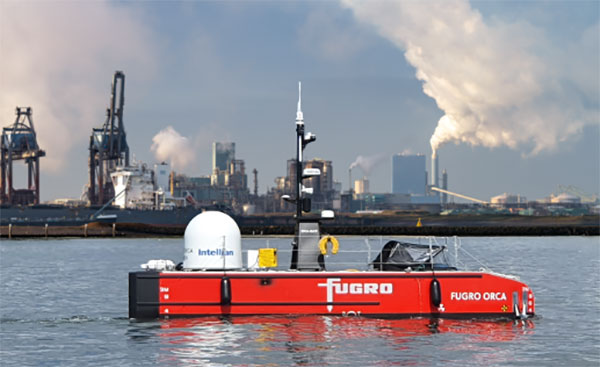
    Fugro’s Blue Essence, an offshore certified uncrewed surface vessel (USV) with an electric remotely operated vehicle (eROV), will begin its first project in the Netherlands.

    The vessel is controlled from an onshore remote operations center (ROC) via a satellite connection. It will be used for the inspection of offshore assets, construction support services, and hydrographic and geophysical surveys.

    USVs play an important role in the future of the maritime sector by improving safety, reducing carbon emissions, and delivering data more efficiently. USV operations remove personnel from high-risk offshore environments to an onshore ROC and reduce carbon footprint by 95 % when compared to traditional survey methods. Cloud-based data processing allows near real-time data delivery, leading to faster and more informed decision making.

    “We welcome this special vessel in our port. It’s the first time a remotely controlled uncrewed vessel will go to the North Sea from the port of Rotterdam to carry out a project without any personnel on board,” said René de Vries, Harbour Master of the Rotterdam Port Authority. “We are proud that this project will be executed safely due to the careful preparation of all parties involved. We expect the development of digitalization in the shipping sector will improve the safety and accessibility of the Rotterdam port.”

    Since 2020, Fugro has been deploying its Blue Shadow USV fleet for medium- to large-scale hydrographic survey applications. Fugro’s first Blue Essence has completed its first remote inspection, in Asia Pacific.

    “I am excited that we now also have this newest generation of USVs available for European clients,” said Erik-Jan Bijvank, group director Europe and Africa at Fugro. “Over the coming years, Fugro will further expand its fleet of USVs for safer, more sustainable solutions for marine operations.”

  • NovAtel releases Oceanix Nearshore correction service for marine applications

    NovAtel, the OEM supplier of high-precision GNSS positioning technology, unveiled its Oceanix Nearshore correction service at the Ocean Business show in Southampton, U.K.

    Oceanix Nearshore, a subscription-based GNSS correction service for Precise Point Positioning (PPP), provides exceptionally reliable subdecimeter positioning for marine applications such as dredging, hydrographic survey, mapping and coastal patrolling.

    The robustness of Oceanix infrastructure sets it apart from the competition. Oceanix precise corrections data is generated utilizing a network of over 80 strategically located GNSS reference stations globally.

    Oceanix’ high-rate corrections ensure the full accuracy of carrier phase is gained for enhanced solution accuracy. Oceanix corrections are delivered via geostationary satellites over L-band directly to the enduser, providing reliable high accuracy positioning worldwide.

    “NovAtel is in the unique position to have control over the entire PPP data generation process as well as the positioning algorithms that drive GNSS receiver performance, delivering the best user experience for our marine customers,” said Miguel Amor, chief marketing officer for Hexagon Positioning Intelligence. “With the launch of Oceanix Nearshore, our customers now have the ability to obtain not only world-leading GNSS technology, but also a truly robust correction service and integrated support all from a single vendor.”

    Oceanix offers multiple subscription durations so that our clients can obtain the service that best fits with the needs of their application. Driven by the NovAtel CORRECT positioning engine, Oceanix Nearshore delivers 4 cm horizontal and 6 cm vertical accuracy rms. Algorithms proprietary to NovAtel CORRECT greatly enhance the accuracy and recovery speed from GNSS signal interruptions.

  • Fugro delivers surface current data with new system

    ROCIS is an airborne system for mapping surface current conditions over a wide area of ocean for current-sensitive offshore operations.
    ROCIS is an airborne system for mapping surface current conditions over a wide area of ocean for current-sensitive offshore operations.

    Fugro and technology partner Areté Associates have successfully delivered near real-time, synoptic, surface current data to characterize Loop Current and Loop Current eddy conditions in the U.S. Gulf of Mexico during a period of intense current conditions.

    Over the course of the five-month program, Fugro used the new ROCIS (Remote Ocean Current Imaging System) to survey currents over a distance of more than 125,000 kilometers — the equivalent of 3 times around the world.

    ROCIS is the first commercially available system of its kind and represents a step change in technology for mapping surface current conditions over a wide area of ocean for current sensitive offshore operations.

    Optimizing recent advances in remote sensing and aerial survey, Fugro and Areté Associates developed a system that uses a combination of digital camera technology and highly accurate positioning systems, together with advanced algorithms, to derive surface currents from wave spectra measurements. It can be installed on a suitable survey aircraft, together with an inertial navigation system augmented by Fugro’s Starfix satellite positioning system.

    Current data are reviewed in real time on board the aircraft, providing continuous assessment of data quality and the location of strong currents. Within an hour of the aircraft landing the system produces a “quick-look” map of the currents over the area while processed data files are available a few hours later.

    During the program, ROCIS data supported day-to-day operational planning and enhanced the accuracy of 3D hydrodynamic current forecast modeling.

    The key technical benefits of ROCIS are the near synoptic, wide area, high resolution, high integrity surface current measurements that allow sub-mesoscale circulation to be measured and monitored. During a four-hour flight, the system can survey ocean currents at 250-meter intervals over a track of 900-1,100 kilometers. To map currents over a similar distance using traditional methods would take a combination of four vessels 24 hours. Given sufficient daylight hours, two ROCIS flight missions can be conducted each day.

    ROCIS services can be provided to single or multiple clients to monitor offshore current conditions over specific locations or a broad area. The system can also provide support in emergency situations such as oil spill and search and rescue, as well as in oceanographic research programs.

    Fugro and Areté Associates are working on further development of the ROCIS system and services, including the use of expendable probes and the incorporation of additional airborne sensors. In 2016 Fugro will add a second ROCIS unit to further enhance its support of offshore operations.

  • Project Counters Ionospheric Disturbance for GNSS

    The monitoring station in Brazil uses a Septentrio PolaRxS receiver to monitor the ionosphere, a Septentrio AsteRx3 to perform tests static and kinematic tests, and three RTK Altus APS3 receivers (one as a base station and two as rovers.)
    The monitoring station in Brazil uses a Septentrio PolaRxS receiver to monitor the ionosphere, a Septentrio AsteRx3 to perform tests static and kinematic tests, and three RTK Altus APS3 receivers (one as a base station and two as rovers.)

    After 27 months of intensive research, a project team funded under the European Union’s 7th Framework Programme has come up with a solution to counter the problem of ionospheric disturbance affecting GNSS signals.

    The CALIBRA project recently showcased a commercially applicable approach to mitigate the phenomenon’s impact on high-accuracy GNSS positioning techniques. In  two demonstrations, the project’s newly developed algorithm was successfully tested in actual precision agriculture and offshore operations.

    Solar flares can cause ionospheric disturbance, a sudden increase in radio-wave absorption that often delays the propagation of signals and ultimately affects positioning. The problem has kept researchers busy for years.

    The CALIBRA project team has been participating in this global research effort by focusing on Brazil, which is one of the most exposed regions due to its proximity to the magnetic equator. Add to this that the sun is at its peak of activity since it entered its new 11-year cycle in 2010.

    The project achieved three main milestones. First, the team confirmed that ionospheric scintillation and variations in total electron content (TEC) had a direct impact on the functioning of high accuracy GNSS techniques, such as Precise Point positioning (PPP) and real-time kinematic (RTK) positioning. Then a suitable metric was established to characterize these ionospheric disturbances. Finally, the project produced a short-term empirical model for forecasting TEC and scintillation. A regional TEC map was developed which proved advantageous for use in Brazil and, to counter scintillation, a number of approaches for the mitigation of this phenomenon were proposed and their benefit demonstrated.

    The project exploited the CIGALA-CALIBRA network and database — a network of ionospheric scintillation monitor receivers with a web interface (the ISMR Query tool), which collects more than 10 million observations on GPS, GLONASS, Galileo, BeiDou and other global navigation systems every day. Since it was launched in December 2014, this data has helped assist users from more than 20 countries because of the software’s visualization and mining techniques.

    In light of this success, CALIBRA partners INGV (Istitute Nazionale di Geofisica e Vulcanologia) filed a patent for their forecasting model, and a new spin-off company — SpacEarth Technology — was set up. SpacEarth’s main purpose is to secure the software’s commercialization in relevant applications and services, while also improving and adapting it to evolving market needs.

    The project’s results promise to considerably reduce downtime and financial losses caused by ionospheric disturbance in Brazil and other regions of the world. Learn more about the project here.

    Another ionospheric mitigation project was presented at the European Navigation Conference earlier this month.