Organizations work together to fight cyber attacks with innovations to visualize threats.
Esri and the U.S. Department of Energy’s Idaho National Laboratory (INL) have entered into a cooperative research and development agreement (CRADA) to collaboratively research and create prototype concepts with a specific focus on location intelligence solutions for the protection of critical infrastructure and critical missions.
The work will also estimate the impacts on critical infrastructure caused by exploited cyber vulnerabilities and targeted attacks.
Esri provides geospatial analysis and visualization capabilities across infrastructure industries like water, electric, oil and transportation, as well as in support of federal, state and local governments charged with the mission of protecting those industries.
These capabilities, combined with INL’s knowledge and capabilities for securing these systems from physical and cybersecurity threats, make this cooperative research and development effort truly unique in addressing crucial gaps in cyber/physical analysis and situational awareness technologies.
INL is the nation’s leading center for nuclear energy research and development, working in energy, national security, science, and the environment. Esri and INL have worked together for more than three years.
“We are looking forward to working closely with INL in this capacity,” said Brian Biesecker, technical director, Esri intelligence community. “As the government continues to embrace new technologies, CRADAs provide a great way for private and public partnerships to continue moving our country forward.”
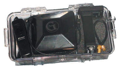
Components easily pack into a baseball-style case. Photo: Nicholas DiGruttolo
By Nicholas DiGruttolo
When asked to do a small survey job overseas, we were concerned about shipping bulky and expensive survey equipment. Shipping costs are not trivial. Add to that the real possibility that your survey equipment may be confiscated by the local authorities, as ours was in Djibouti, and the cost of shipping equipment becomes a substantial part of the overall job. There should be alternatives, especially if accuracy requirements are not stringent.
Faced with this problem for a second time, we considered a new receiver system that has many advantages over conventional survey-grade GNSS receivers: It is small, lightweight and low-cost without sacrificing performance, making it ideal for precision surveying in remote areas of the world and for traveling to the job site by commercial airline. All the components, including the tripods, rods and batteries, are constructed from commercial off-the-shelf (COTS) components. A complete base and rover kit fits in a baseball bag and weighs less than 10 kilograms. The kit is sized and approved as carry-on luggage.
The system is scalable from a simple single-frequency semi-mobile receiver for control networks and some semi-kinematic mapping applications, to a dual-frequency network RTK solution.
The system comes with free processing software that supports carrier-phase relative positioning in real time and post mission, as well as precise-point positioning (PPP) and CA-code differential correction. The software is designed with a simple user interface for easy selection of base and rover data or automatic data download of the closest Continuously Operating Reference Station (CORS) from the U.S. National Geodetic Survey database.
Complete survey set including GNSS receiver, antenna, battery and cables, fits in a small handheld plastic case. Photo: Nicholas DiGruttolo
The system fills a gap between survey applications, where centimeter-level precision is an absolute necessity, and mapping applications, where meter-level is tolerable. The product offers sub-foot precision in most cases and centimeter precision in ideal situations.
Our team recently performed topographic mapping of an oil refinery site in Saudi Arabia and surveyed a precise-elevation network in Sarasota, Fla., to research the effects of sea-level rise. The small size of the COTS components simplified transport to Saudi Arabia, eliminating additional airline baggage fees and easing import through customs. Researchers performing the sea-level study reduced field time by increasing the number of receivers needed to observe a robust vertical control network.
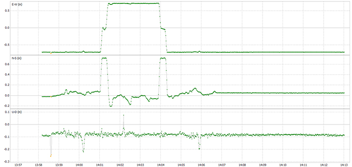
Oil Refinery. The oil refinery project entailed mounting a GNSS antenna on the roof of an off-road vehicle and driving multiple transects around the 18-kilometer perimeter of the site to record the elevation of the terrain. Kinematic data was recorded at 1 Hz using a GPS-only version of the single-frequency receiver. Baseline length to the local reference station varied from less than 1 kilometer to about 10 kilometers. The site was open desert with no overhead obstructions or sources of multipath other than the roof of the vehicle on which the antenna was mounted. Post-processing and comparison to simultaneously collected data from a high-precision survey-grade receiver revealed positional accuracy of about 5 centimeters horizontal and 10 centimeters vertical, when the system’s trajectory was compared to the truth trajectory provided by the survey-grade receiver. Figure 1 shows the difference between the two trajectories. The system’s antenna was 2 feet away from the survey-grade antenna along the driving direction of the vehicle; the trajectory was mostly in the north-south direction and hence the 0.6-m offset in the plot!
Figure 1. Antenna location difference in the sub-decimeter range between the survey-grade system and the compact low-cost system. Note: A 0.6-m offset is to be removed from the difference, as the two antennas were mounted 0.6 m apart in the vehicle driving direction.
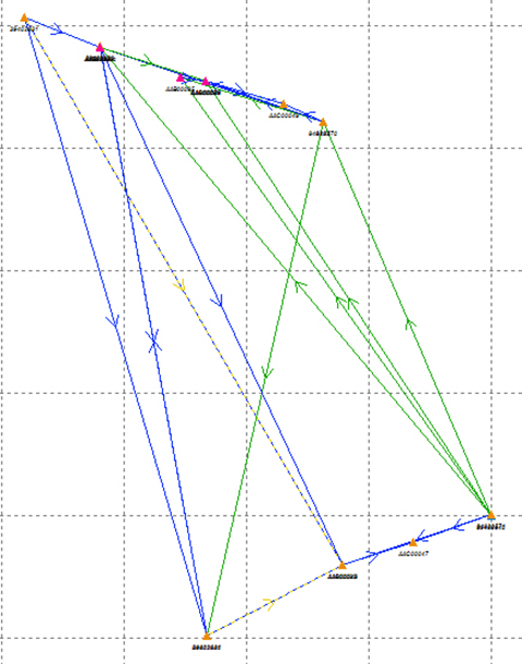
Sea Level. The sea-level-rise study required a high-accuracy vertical control network to cover a 2,500 hectare area. The purpose of the network is to determine the shortest term effects of sea-level rise with a rate of 1.8 millimeter/year in the affected area. Ten benchmarks were established throughout the area of interest, and a robust network of static observations was performed with a combination of two dual-frequency and two single-frequency receivers. The single-frequency receivers were GPS-only units where two standard 4-inch patch antennas were mounted on rods adjusted to a 0.9-meter height. The addition of two receivers provided greater redundancy and a stronger network solution in much less time than would have been possible with only one pair of survey-grade receivers. Figure 2 shows the addition of several loop ties to the network as a result of adding the two roving, lightweight receivers.
Figure 2. Sea-level rise monitoring network showing increased tie points and redundancy as a result of adding the extra lightweight precision receivers to the survey-grade receivers.
Nicholas DiGruttolo works as a field surveying manager for JBrown Professional Group Inc., Northrop Grumman Corporation, and has recently become vice president of surveying.
Bartec Pixavihas launched the “Impact X intrinsically safe smartphone” based on u-blox’ rugged 3G cellular module technology designed for devices used in tough industrial and outdoor environments. Bartec Pixavi is a manufacturer of mobile devices used in hazardous or explosive environments such as oil platforms, mines and chemical plants.
“Our Impact X smartphone is designed with the most robust, reliable and safe components available to ensure security and provide reliable connectivity to workers in potentially dangerous locations,” said Christian Rokseth, CEO of Bartec Pixavi. “We chose u-blox’ cellular module technology because of its industry-leading performance, excellent environmental tolerance and reliability.”
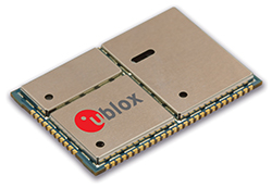
u-blox LISA u230 module. Photo: u-blox
The Impact X is CSA Class 1, Zone 1, IECEx and ATEX Zone 1 certified, explosion proof, waterproof and extremely ruggedized. At the heart of the Impact X is u-blox’ professional-grade LISA-U230 six-band 3G cellular module with 2G fallback capability. LISA modules also provide fully integrated access to u-blox GNSS receivers to enable advanced location-aware applications. Antenna diversity permits LISA-U2 modules to provide the highest data speeds.
“The Impact X is an excellent example of a high-performance mobile device that demands performance well beyond what is provided by standard mobile phones,” said Armin Boeshenz, General Manager of u‑blox sales EMEA. “We are extremely pleased to be a key module supplier to demanding customers such as Bartec Pixavi as proof of our industry-leading quality and reliability.”
u-blox LISA-U2 modules are suited for networks worldwide. Features include data-rates of up to 21.1 Mb/s (downlink), a rich set of Internet protocols, very small footprint, very low power consumption and extended operating temperature range of -40 to +85 degrees C.
PeopleNet, a Trimble company and provider of fleet mobility technology that optimizes performance and decision-making management, has launched a mapping and navigation solution for its Energy Services suite, serving U.S. fleets in the upstream and midstream sectors.
“Our Energy Services suite capitalizes on our proven fleet mobility solutions that increase efficiency, safety and compliance for all oilfield service segments, including producers, oilfield construction and well service companies, as well as haulers of fluid and crude oil. In addition, we’re leveraging our parent and sister companies’ industry-standard lone-worker, mapping and navigation technologies to fast-track development of new services to continue improving operations for Energy Services fleets,” said David Buhl, leader of PeopleNet’s dedicated Energy Services Division.
PeopleNet’s new Energy Services mapping and navigation solutions are based on exclusive, detailed maps of private and leased oilfield roads that facilitate vehicle navigation to and from well sites, coordination of disparate workforces to promote efficiency, location monitoring of equipment to ensure vehicles are on the correct route for least-cost routing. The Oil and Gas Map Portal is a web-based application used by back-office dispatch personnel to manage the navigation needs of vehicles and includes reporting, dashboards, and scorecards that help manage compliance with producer-landowner road-usage agreements.
CoPilot Oil and Gas Navigation is an in-cab application that uses oil and gas field mapping for providing turn-by-turn directions to the driver to enable on-time arrivals and scheduling. Location data, including wells, is installed onto the in-cab device and is accessible in the points of interest menu. When a location is selected, the application provides turn-by-turn directions to the driver.
A growing number of energy services fleets are using PeopleNet technology to promote on-time schedules, enhance service levels and improve safety/compliance, including Gibson, Missouri Basin Well Service, Nuverra Environmental Solutions, Rockwater, and Tankstar USA.
These new services are based on reliable two-way messaging and GPS, supported by tri-mode communications (cellular, satellite and Wi-Fi). They are being added to PeopleNet’s current Energy Services offerings, which include: Crude Workflow for improving driver efficiency; eDriverLogs HOS application with oil field regulations; Speed Gauge speed monitoring; and Automated Fuel Tax reporting for eliminating manual trip sheets.
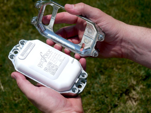
GT-1 asset tracker combines GPS, RFID, and Bluetooth technologies. Photo: Geoforce
Geoforce, Inc. is announcing commercial availability of its GT-1 asset tracking device that can track field equipment in locations and conditions previously too challenging for other devices to function effectively. A globally certified GPS device, the GT-1 enables oil and gas service providers to proactively monitor and share data on vehicles and equipment for more cost effective operations, helping to meet ongoing environmental responsibilities, the company said.
“We have been waiting a long time for a device like this,” said Michael Rolston, operations manager at Permian Equipment Rentals. “It’s small, it’s incredibly rugged, it will last years without replacement. It’s also surprisingly low cost — given all its features and capabilities.”
The GT-1 was previously offered in limited release to several major international service and rental companies beginning in the fourth quarter of 2012. To date, thousands have shipped and are actively tracking oilfield assets around the globe.