Trimble VRS Now coverage in Australia. Photo: Trimble
Trimble, together with its distribution partner Ultimate Positioning Group, announced the availability of Trimble VRS Now correction service in Queensland, New South Wales, South Australia, Tasmania and Victoria.
Trimble is also now offering the Trimble VRS Now correction service in Oregon’s Willamette Valley.
The commercial subscription service provides surveyors, civil engineers, geospatial professionals and other industry specialists in these areas with instant access to real-time kinematic (RTK) GNSS corrections without the need for a base station.
Using both GPS and GLONASS constellations, the Trimble service delivers centimeter-level RTK corrections customized for each GNSS receiver’s location anywhere in the network via cellular communications. The Trimble VRS Now service supplies accurate, reliable and easy-to-use GNSS positioning for a variety of applications including surveying, urban planning, urban and rural construction, environmental monitoring, resource and territory management, disaster prevention and relief and scientific research, Trimble said.
“The addition of VRS Now to Trimble’s current portfolio of corrections technologies and services in Australia highlights our ability to meet any accuracy, delivery, availability and financial consideration across a variety of applications and markets,” said John Sprivulis, business area director of Trimble’s Positioning Services Division in the Asia Pacific. “Trimble is effectively creating a national positioning infrastructure to meet Australia’s future needs.”
Trimble VRS Now in Australia is a continuation of Trimble’s focus on providing solutions that enable customers to increase productivity by simplifying access to high-precision accuracy around the world. Similar VRS Now services are operating in parts of the U.S. and Europe.
In addition, the Australian VRS Now service supports the Trimble Pivot Field Mobile App, which provides up-to-the-minute information on the VRS Now system status for users in the region.
Because OmniSTAR CORS service in the area is being phased out, existing Australian users will be automatically transitioned to the Trimble VRS Now service, which provides easy access to high accuracy and reliable positioning within the network coverage area.
Service in Australia and Oregon is a continuation of Trimble’s focus on providing solutions that enable customers to increase productivity by simplifying access to high-precision positioning around the world. Similar VRS Now services are operating in Illinois, Indiana, Iowa, Nebraska, Colorado, Florida, Alabama, Mississippi, Texas, and parts of Europe.
Eos Positioning Systems has introduced a new line of high-accuracy GNSS receivers for smartphones and tablet computers, including both sub-meter and RTK performance for all mobile platforms: iOS, Android, and Windows.
Eos’s entry-level product, the Arrow Lite, is Bluetooth compatible with all mobile devices.
The Arrow 100 is Eos’s advanced real-time, sub-meter GNSS receiver that utilizes both GPS and GLONASS, and is expandable to Galileo, Beidou and QZSS. It offers superior tracking under tree canopy, around buildings and in rugged terrain, the company said. In addition to supporting SBAS in North/Central America, Europe, Northern Africa, Japan, India and Russia, the Arrow 100 also supports OmniSTAR’s worldwide, real-time sub-meter service.
The most advanced Arrow receiver is the Arrow 200, a dual-frequency, multi-constellation RTK GNSS receiver capable of 1-cm accuracy in real time. The Arrow 200 is an iOS-compatible RTK and OmniSTAR receiver that works with all models of iPads and iPhones via wireless Bluetooth connection. An iOS NTRIP app that allows the user to log into any available RTK network. The Arrow 200 will provide quality RTK performance for years to come because it supports current and future satellite constellations: GPS, GLONASS, Galileo, BeiDou and QZSS, the company said. It also supports OmniSTAR’s G2, XP and HP real-time worldwide decimeter services.
“After spending more than 12 years designing high-accuracy Bluetooth GNSS receivers, I believe Eos has set the new standard for high- accuracy GNSS receivers that work across all mobile platforms, no matter if it’s iOS, Android or Windows,” said Chief Technology Officer Jean-Yves Lauture.
All Arrow receivers employ long-range (1-km) universal Bluetooth connectivity so the user can interface to any brand of smartphone or tablet, whether it’s iOS, Android, or Windows-based. A variable-power Bluetooth implementation allows the Arrow receivers to communicate up to one kilometer from the mobile device.
Arrow receivers have been optimized to run all day on battery power. The battery pack is field-replaceable and rechargeable separately. It contains smart charging logic so expensive battery chargers are not needed.
All Arrow receivers have been designed to meet IP-67 specifications for immersion in water and are completely dust-proof so they will survive in the harshest environments.
The Arrow receiver product line is targeted at high-accuracy applications like GIS, environmental, agriculture, electric/gas/water utilities, surveying, machine control, and federal/state/local government.
The 2014 Trimble Dimensions User Conference is being held in Las Vegas this week. Photo: Trimble
With more than 4,000 attendees, this year’s Trimble Dimensions User Conference was the largest ever and, I must say, a well-organized event chock full of technical content — enough to squelch the most intense geospatial hunger pangs you might have.
One could write a book on all the technology and market segments that Trimble is pursuing and offering solutions for. In addition to a wide range of GNSS, geospatial, construction, control, and data management systems previously offered, Trimble boasted a USB stick full of press releases with new product and service announced at Dimensions. So, the challenge is deciding what to write about without writing a little bit about everything.
After my first day at Dimensions, it became clear to me what I needed to do. Among the many product and service announcements was a new GNSS correction service named Viewpoint RTX. While I’ve tried to stay up to speed on Trimble’s various GNSS real-time correction services, this one was the straw that broke the camel’s back for me. I decided I needed to get a solid grip on the range of real-time GNSS correction services that Trimble offers because the picture was getting fuzzier, at least to me, with each new real-time correction service introduced. It used to be pretty simple to decipher; not so much any longer. So I had a conversation with Patty Boothe, general manager of Positioning Services at Trimble. Patty, a 15-year Trimble veteran, was appointed GM of the newly formed group three years ago. Here’s the low-down on the services.
Remember, Trimble acquired the land portion of OmniSTAR’s business a few years ago. For years, OmniSTAR has been one of the two dominant commercial satellite-based, real-time GNSS correction services (the other being John Deere’s Starfire service, as well as new entrant Terrastar). The OmniSTAR acquisition was Trimble’s entry into the satellite-based, real-time GNSS correction services business. Since then, Trimble has introduced the RTX (not to be confused with RTK) range of GNSS correction services. You might say that OmniSTAR and RTX are competitive services within Trimble. They are, to a certain extent, and I’ll attempt to clarify that below.
Following is a list of Trimble’s real-time GNSS correction services, starting with the OmniSTAR services:
OmniSTAR VBS: Satellite-based, real-time submeter service. The VBS service has been made obsolete largely by free public satellite-based augmentation systems (SBAS) such as WAAS/EGNOS/MSAS/GAGAN/SDCM. It is still used in geographic regions where free public SBAS don’t exist, primarily South America, Central and Southern Africa, and Australia. GPS-only service. Requires single-frequency receiver (L1).
OmniSTAR XP: Satellite-based, real-time 15-cm service based on Jet Propulsion Lab (JPL) technology and delivered to users on the ground via OmniSTAR’s geosynchronous satellite network. GPS-only service. Requires dual frequency (L1 and L2).
OmniSTAR HP: Satellite-based, real-time 10-cm service based on OmniSTAR’s reference station network and delivered to users on the ground via OmniSTAR’s geosynchronous satellite network. GPS-only service. Requires dual frequency (L1 and L2).
OmniSTAR G2: Satellite-based, real-time 10-cm service based on Jet Propulsion Lab (JPL) technology and delivered to users on the ground via OmniSTAR’s geosynchronous satellite network. GPS+GLONASS service. Requires dual frequency, dual constellation (L1 and L2).
To use OmniSTAR services, one must have an OmniSTAR-enabled GNSS receiver. There are a several receiver manufacturers that support OmniSTAR GNSS correction services, such as NovAtel and Hemisphere GNSS, in addition to Trimble.
After, or at nearly the same time, Trimble acquired OmniSTAR, the company launched its RTX GNSS correction service. RTX’s infrastructure consists of ~110 GNSS reference stations around the world working to create high-precision corrections on a near global scale. The first significant differentiator is that Trimble RTX services are only offered on Trimble GNSS receivers, so you’ve got to be “all in” with Trimble to utilize RTX.
Viewpoint RTX: Internet-based (notice I didn’t write satellite-based), real-time submeter service. This is a new service introduced this week at Dimensions for the new Leap GNSS receiver and the Geo7 GNSS handheld. GPS+GLONASS service. Requires single-frequency receiver (L1).
The above are the three RTX services. There are some options for the above, but let’s talk about satellite-based GNSS correction services for a minute.
The advantage of satellite correction services is that, because GNSS corrections are delivered via satellite, your receiver doesn’t need to be connected to the Internet or have any other sort of terrestrial radio communications to receive data from the GNSS reference station(s). Because delivery is by satellite, you could be in the middle of a desert with no mobile phone coverage within 100 km, and you could still use OmniSTAR or RTX services. The only requirement is that your receiver needs to have direct, continuous line-of-sight to the OmniSTAR/RTX geosynchronous satellite (both services use the same geosynchronous satellites to broadcast the corrections).
The primary disadvantage of OmniStar and RTX services is the “convergence” time required to achieve the stated accuracy service levels. With the exception of OmniSTAR VBS (sub-meter), Viewpoint RTX (sub-meter) and Rangepoint RTX (50-cm) services, the OmniSTAR and RTX centimeter and decimeter services require tens of minutes of initialization time to converge to the stated accuracy. For example, if you want to use the 4-cm Centerpoint RTX service, you may have wait up to 30 minutes for it to converge to 4-cm accuracy.
Now, there are a couple of ways to reduce the convergence time:
Start on a known point. For example, if you’re using Centerpoint RTX on a tractor for planting and you shut down for the evening, you can start it up the next morning (assuming you didn’t move the tractor), and it will converge nearly immediately.
Trimble offers a fast convergence option ($) in some geographic areas where it augments RTX with local RTK reference stations. Currently, Trimble offers this service in five U.S. “corn belt” states.
For OmniStar XP, HP and G2 services, the only way to reduce convergence time is number one above, start on a known point.
It’s important to note that all of the centimeter and decimenter satellite-based services described above are based on real-time Precise Point Positioning (PPP) technology, which is different than RTK technology. The fundamental difference is that real-time PPP technology relies on a global, distributed network of reference stations. For example, Trimble has ~110 reference stations to cover the globe (mostly) with its RTX service. On the other hand, RTK requires a much more dense network of GNSS reference stations. For example, in Washington State there are ~100 GNSS reference stations that comprise the state-wide RTK network.
Lastly, Trimble offers a hybird RTK/RTX service called XFill. The idea is that for RTK users who lose communications to their RTK base or RTK network can use the Centerpoint RTX as a “seamless” back-up, maintaining RTK-level accuracy (1-2cm) for the first five minutes of RTX service, and then degrading to Centerpoint RTX accuracy after 20 minutes. Trimble reports there is no convergence time when transitioning from RTK to RTX, like you would if you were starting RTX right away. Standard XFill is included with certain Trimble RTK receivers and allows up to five minutes of RTX satellite time. Last month at the INTERGEO conference, Trimble introduced Expanded XFill which is a subscription service for those users who want more than five minutes of RTX time. For those users, Patty said that users can buy blocks of RTX time starting at 10 hours.
So, you might ask how Trimble handles the horizontal datum differences between RTK and RTX since they are likely not referenced to the same horizontal datum. For example, in the US, Trimble VRS RTK infrastructure is typically referenced to NAD83/2011 while Trimble RTX is referenced to ITRF08. There’s about 1 meter difference between the two. After finding the correct Trimble person, he said that Trimble does a 3-parameter local shift (dX, dY, dZ) on the fly when in RTK mode so that when there’s a transition from RTK to RTX, the horizontal datum difference is already resolved.
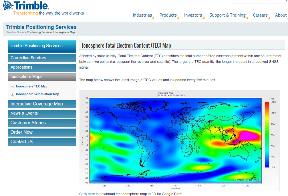
A by-product of Trimble’s ~110 global GNSS reference station network is a real-time, world-wide TEC (Total Electron Content) map. Since real-time PPP GNSS correction services (and public SBAS like WAAS/EGNOS/MSAS/GAGAN) rely on accurate models of the TEC in the ionosphere to account for the GNSS measurement delay, real-time TEC maps give users an indication of how the ionosphere’s TEC is behaving. This sort of map is particularly useful in attempting to predict the understand single frequency receivers using services such as public SBAS, OmniStar VBS, and Viewpoint RTX. The next time you here about an impending solar storm, take a look a the map using this link and see the TEC hotspots around the globe. Notice the more intense activity near the geomagnetic equator.
TEC map from Trimble’s ~110 global GNSS receivers. Photo: Trimble
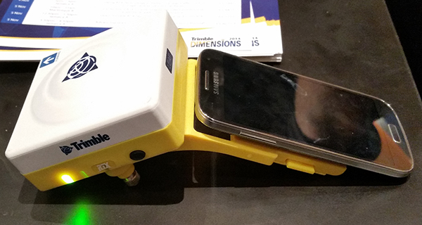
Shifting gears slightly, at the conference, Trimble also introduced a new mobile phone GNSS add-in product called Leap, which uses the Viewpoint RTX service.
Trimble Leap GNSS Receiver with a Samsung Galaxy Phone. Photo: Trimble
Geneq Inc. has introduced the SXBlue III-L GNSS, a palm-sized L1/L2/GLONASS GNSS receiver that is designed to use OmniSTAR’s G2 or HP service to attain realtime 10-cm accuracy in all regions of the world, including North/South America, Australia, Asia, Africa, Europe, and the Middle East. The SXBlue III-L GNSS connects wirelessly to smartphones, handhelds, tablet or notebook computer that are bluetooth-compliant. Optionally, the SXBlue III-L GNSS receiver is fully RTK capable (1cm real-time accuracy) when using an RTK network or other RTK reference station.
Photo: Geneq
According to the announcement, the SXBlue III-L GNSS is designed to use OmniSTAR’s G2 service, which supports GPS and GLONASS satellites, to provide 10cm accuracy in real-time in most parts of the world. The ability to track both GPS (31 satellites) and GLONASS (24 satellites) significantly increases the number of satellites in view, making the SXBlue III-L GNSS more productive in areas where trees, terrain or buildings block satellite visibility. It also outputs raw observation data that can be used for post-processing using free, online processing software services such as OPUS.
“We’ve set a new standard for world-wide, real-time high-precision mapping using OmniSTAR’s G2 service,” said product engineer Jean-Yves Lauture. “The affordable price and flexibility of the SXBlue III-L GNSS makes worldwide, dual frequency, dual constellation 10cm real-time accuracy available to a wide number of users.”
In addition to the OmniSTAR service, the SXBlue III-L GNSS also supports RTK GNSS. “If you want 1cm real-time accuracy, the RTK option lets the user connect to an RTK Network or a single RTK base station using standard RTCM and common industry formats,” said Lauture. “And, in that case, the RTK network or RTK reference station doesn’t need to support GLONASS for the SXBlue III-L GNSS to fully utilize the benefits of GLONASS.”
The company reports the SXBlue III-L GNSS measures 14.cm (5.57”) x 8.0cm (3.15”) x 5.6cm (2.22”) and weighs slightly over a pound (1.14lbs, 517g) including battery. The SXBlue III-L GNSS is the smallest and lightest GNSS L1/L2 OmniSTAR receiver being produced in the world today.
The SXBlue III-L GNSS is compact and rugged for optimal field use, requiring no backpack or external batteries. It was designed to meet the IP-67 rating, and can survive accidental immersion in water. The SXBlue III-L GNSS comes with a small, hermetically-sealed antenna that receives GPS, GLONASS, SBAS and OmniSTAR signals.
The SXBlue III-L GNSS is targeted at high-precision users in industries such as surveying, GIS, utilities, construction, agriculture, engineering and other natural resource industries in addition to local, state and federal government users.
Trimble introduced new versions of its office and field surveying software—Trimble Business Center Software version 2.70 and Trimble Access software version 2012.10. The software is part of Trimble’s portfolio of Connected Site survey solutions. The new software enhancements allow surveyors to collect, share and deliver data faster to improve accuracy, efficiency and productivity.
“Trimble is focused on providing Connected Site solutions that minimize rework and improve productivity. Workflow integration and connectivity provide surveyors with the day-to-day flexibility to adapt to a variety of situations in the field and office,” said Anders Rhodin, director of Trimble’s Survey Business. “Trimble’s portfolio of software solutions gives surveyors improved workflows for field data collection and enhance collaboration between the field and the office.”
Trimble Business Center Software Version 2.70
Version 2.70 advances the capabilities of surveying offices with key new functionality, including:
Photogrammetry – When a surveyor’s project contains images from Trimble VISION™ Total Stations or Trimble VX Spatial Stations, users can make photogrammetry measurements and calculate points with three-dimensional (3D) coordinates.
Support for Polygon Features – Using the Feature Definition Manager application, surveyors can create and edit polygon feature definitions for inclusion in a library (.fxl) file. Polygon features are useful for modeling real world terrain features such as bodies of water, building footprints, and parcel boundaries.
New GNSS Baseline Processor – The baseline processor has been enhanced to provide improved accuracy and support for RINEX 3.0 and ANTEX antenna model formats. Users can post-process GNSS observables faster by taking advantage of multi-core computer processing. By decreasing the time it takes to process baselines, the software enables office surveyors to spend more time analyzing results and creating deliverables.
Trimble Access version 2012.10 offers new functionality, including:
Volume Calculation and Surface Creation – Surveyors can now compute volumes and create surfaces in the field on any of the following: Trimble Tablet, TSC3, TSC2, or Trimble CU Model 3 Controllers, plus the Trimble S3 and Trimble M3 Total Stations.
Panorama Image Capture – All Trimble S Series total stations equipped with Trimble VISION technology can now take multiple images seamlessly using the panorama function.
Target Interrupted Measurements – A new “Interrupted Target Measurement” feature is now available on all Trimble VX Spatial Stations and Trimble S8 and S6 Total Stations. This feature allows successful measurements in difficult environments where a measurement is likely to be interrupted – for example, when surveying across a busy road.
OmniSTAR Support – Customers with a Trimble R7 GNSS System, the latest version of Trimble Access and a subscription to OmniSTAR corrections signals, can now take advantage of real-time, differential positioning without a radio link. OmniSTAR services can be used for real-time differential surveys or as a fallback for RTK surveys when a ground-based radio link is down or unavailable.
Trimble’s Connected Site Solutions
Trimble’s Connected Site solutions for surveyors create seamless working relationships among Trimble products, technologies and services. Through the Connected Site, Trimble is focused on providing solutions that address the customers’ full work processes. By carefully combining technology innovation with a deep understanding of the users’ workflows, data integration and maintenance across the lifecycle of projects, Trimble helps surveyors reach new levels of productivity for their businesses.
Availability
Trimble Business Center Software version 2.70 and Trimble Access software version 2012.10 are available now through Trimble’s Survey Distribution Channel.
In my 20-plus years of involvement in the GPS/GNSS industry, nothing has come close to the LightSquared debate for technical and political complexity, nor for potential effects on nearly every high-precision GPS/GNSS user in the United States. The industry’s destiny is somewhat controlled by a federal agency that is not very knowledgeable about how, when, and where GPS is used — although I’m sure they’ve learned a lot in the last 14 months.
While receiver manufacturers have a firm grip on the technical complications of what LightSquared proposed, they have jockeyed for market position, as information released to the public is filtered through their marketing heads. Finally, media coverage is all over the place, from “LightSquared is doomed” to “this will happen.”
On January 13, as we all know, the U.S. deputy secretaries for defense and transportation wrote, on letterhead of the Space-Based Positioning Navigation & Timing National Executive Committee (PNT EXCOM), to the head of the National Telecommunications Information Administration (NTIA), declaring that “there appear to be no practical solutions or mitigations that would permit the LightSquared broadband service, as proposed, to operate in the next few months or years without significantly interfering with GPS.”
On February 14, the NTIA director wrote to the Federal Communications Commission (FCC) chairman in a similar vein with nearly the same language. That same day, the FCC stated its intent to “not lift the prohibition on LightSquared,” and to “vacate the Conditional Waiver Order, and suspend indefinitely LighSquared’s Ancillary Terrestrial Component authority.”
It just so happens that LightSquared cannot accomodate military GPS users nor aviation GPS users. Those of you who use high-precision GPS can thank your lucky stars that the military and aviation folks are standing in your corner. Otherwise, as I warned back in May of last year, high-precision users would have been thrown under the onrushing bus of national broadband.
In testimony to a House of Respresentatives subcommittee meeting on GPS and aviation in early February, the Transportation deputy secretary revealed that the Federal Aviation Administration (FAA) spent more than $2 million of taxpayer dollars with two different independent labs to conclude that LightSquared proposals were not compatible with several GPS-dependent air safety-of-flight systems.
Don’t expect the Department of Defense (DoD) ever to provide similar testimony. The Pentagon played its veto card off-air and out of the public eye.
LightSquared has continued to complain about GPS receivers “looking into our spectrum” as the reason for the interference GPS receivers are suffering. If you missed Richard Keegan’s December 2011 article in GPS World, you should take a look. He succinctly addresses this issue, as I did in my November 2011 Survey Scene column.
As LightSquared has clearly lost the engineering argument, it has taken a very creative approach in an attempt to convince the FCC that this isn’t an engineering problem, but rather all about the FCC rules. LightSquared petitioned the FCC to confirm that “GPS devices are not entitled to protection from interference.”
Crazy statement? If you think so, see if you recall reading this statement on equipment such as GPS receivers. It is on almost every electronic device that relies on radio signals.
“This device complies with Part 15 of the FCC Rules. Operation is subject to the following two conditions:
“(1) This device may not cause harmful interference, and (2) this device must accept any interference received, including interference that may cause undesired operation.”
What if LightSquared can convince the FCC that GPS receivers do, indeed, fall within the confines of Part 15 of the FCC rules and aren’t entitled to interference protection? That’s what the company is trying to do, and that’s why this fight ain’t quite done.
Don’t underestimate the power of the White House pushing the National Broadband Plan, or of commercial interests — of which there are myriad — seeking to turn a buck on the hunger, whether real or only perceived, for limitless broadband. Even the transportation depsec allowed in his testimony as how “in the Obama administration, we believe deeply in what LightSquared is attempting to do, which is to make the Internet more accessible to more people all across the country. This is an urgent national priority.”
Communications for My RTK
Some people in the GPS industry who believe that the LightSquared service will do wonders for RTK operations, somehow replacing the communications methods we currently use (UHF/VHF, 900MHz, GSM/GPRS, CDMA, Wifi/Mifi, etc.). I disagree.
LightSquared was relying on Sprint’s infrastructure (~31,000 towers) for its terrestrial operations, supplementing them with ~3,400 LightSquared towers at some point. I’ve used Sprint’s mobile phone service for about 12 years and I used Sprint’s data card service for several years (not any longer). I pretty much know that Sprint is good for metro areas and poor for rural areas. Like other wireless providers (AT&T, Verizon, T-Mobile, etc.), Sprint is strong in some geographic areas, and weak in others. Since LightSquared is focused on serving people (densely populated areas) rather than geographic areas (e.g., farmlands), their terrestrial service is not going to be even close to being nationwide. LightSquared’s solution for areas not covered by their terrestrial service is to use satellite communications for Internet connectivity.
If you think you would enjoy ubiquitous coverage with satellite communications for your RTK operations, consider OmniSTAR’s service, which is in the same spectrum as what LightSquared proposed. OmniSTAR works great when there’s a clear view of the sky to one of OmniSTAR’s satellites (ironically, operated by LightSquared) such as in the agriculture industry. But I’ve used it a bit and — just like GPS — it doesn’t work in buildings, in vehicles, under trees, or in other obstructed-sky locations.
Can you imagine using a LightSquared mobile phone that doesn’t work in buildings, in cars, or under trees? You wouldn’t. Anyone who’s ever used RTK knows that spotty base/rover communications is the quickest way to spoil an RTK party. With GPS/GLONASS receivers allowing us to use RTK in places where we’ve rarely ventured before, the limitation wouldn’t be the number of navigation satellites in view, but rather if the LightSquared satellite was in view.
For those of you who heard that LightSquared might have been a good idea in order to make wireless mobile Internet access more affordable, I seriously doubt that statement as well. Documents in a huge Freedom of Information Act release by the FCC reveal what LightSquared was planning to charge its wholesale customers (not retail) when they were out of range of the terrestrial system and forced to use LightSquared’s satellite for wireless broadband. The wholesale cost of their satellite broadband service was to be $10 per megabyte (not gigabyte), an astonishingly high price for a company that’s been touting affordable, nationwide wireless broadband Internet service.
Upgrade Costs
A cool $2.4 billion was the official estimate given for aviation industry upgrades, should LightSquared have gone forward. I think that’s conservative because I doubt it covers the infrastructure upgrade cost (WAAS, GBAS, and so on) or the cost of NextGen program delays.
How about something closer to home? I queried the administrator of a statewide RTK network of 103 GNSS reference stations, and used his estimates to extrapolate national costs in that regard: 7,000 CORS receivers across the United States. They look like this: optimistic scenario, $64 million; likely,$92 million; worst-case scenario, $120 million.
Keep in mind that this is only the high-precision GPS/GNSS infrastructure in the United States. There are still hundreds of thousands of high-precision GPS/GNSS receivers owned by users across the country that would have to be upgraded. For many GPS receivers (think handheld), there will be no upgrade solution, so the manufacturer might offer trade-in credit for a new GPS receiver.
After spending time to understand the actual costs of accomodating LightSquared, one state legislator who initially voiced his support for LightSquared said “we can’t afford it.”
New Beginnings
Included in the NTIA report was a recommendation that, with time, GPS receivers could be redesigned in order to accomodate LightSquared’s 10L signal.
NTIA also reported that during the January 13 EXCOM meeting, it was agreed that “federal agencies will move forward this year to develop and establish new GPS spectrum interference standards that will help inform future proposals for non-space commercial uses in the bands adjacent to the GPS signals and ensure that any such proposals are implemented without affecting existing and evolving uses of space-based PNT services vital to economic, public safety, scientific, and national security needs.”
In summary, GPS/GNSS receiver designs will change in the coming years and move towards more efficient use of spectrum. To me, a critical statement in the NTIA letter to the FCC is “without affecting existing and evolving” — meaning that not only should GPS be considered, but also GPS-like systems from other countries such as Russia’s GLONASS, Europe’s Galileo, and other developing satellite navigation systems and applications.
ERIC GAKSTATTER is contributing editor for survey of GPS World, and editor of Geospatial Solutions.
Trimble today announced that it has entered into a definitive agreement to acquire certain assets related to the OmniSTAR GNSS signal corrections business from Fugro N.V. The acquisition is expected to significantly expand Trimble’s worldwide ability to provide corrections services for land based agriculture, construction, mapping, and geographic information system (GIS) and survey applications.
Trimble and Fugro also entered into a multi-year service agreement which includes Fugro’s ongoing operation of its correction network and satellite service broadcast systems that power the OmniSTAR service. Fugro’s offshore marine business is unaffected. Closing of the transaction, anticipated in the first quarter, is subject to certain closing conditions. Financial terms were not disclosed.
OmniSTAR provides space-based GNSS correction services that can improve the accuracy of a GNSS receiver for precise positioning applications. These are the four levels of OmniSTAR service:
VBS offers sub-meter positioning.
XP service delivers better than 20-centimeter accuracy.
HP service delivers greater than 10-centimeter accuracy.
The new OmniSTAR G2 service combines GPS-plus-GLONASS-based corrections to provide decimeter level positioning.
Trimble pioneered RTK technology in the early 1990s, which enabled high-accuracy corrections for field applications. RTK is now recognized as the industry leading technology for centimeter-level positioning. To further improve accuracy, Trimble subsequently introduced VRS technology in 2000 and shortly after that Trimble VRS Now Service.
“With the addition of the OmniSTAR services and our strong relationship with Fugro, we will offer a full range of high-precision positioning capabilities which now includes satellite-delivered corrections,” said Patricia Boothe, general manager of Trimble’s newly-formed Positioning Services Division. “Today, our agriculture customers use OmniSTAR services to perform planting, harvesting, variable rate application and many other operations. Our expanded portfolio will provide not only farmers, but also surveying, construction, and GIS professionals with more options to satisfy their particular accuracy, delivery, and financial needs.”
“Trimble and OmniSTAR have enjoyed a long standing relationship,” said John Waits, president of OmniSTAR. “The transfer of land-based GNSS signal corrections assets marks the next phase of our efforts to bring a broader range of positioning services to our combined customer base, on land and offshore. The OmniSTAR and Fugro teams remain committed to providing industry leading corrections services for customers who own a variety of GNSS receivers.”
The OmniSTAR business will be reported as part of Trimble’s Engineering and Construction segment.