Tag: OPNT

  • Industry members, non-profit urge Congress to fund GPS alternatives

    Industry members, non-profit urge Congress to fund GPS alternatives

    In separate letters to members of the House of Representatives and the Senate, seven companies and a non-profit urged Congress to support alternative positioning, navigation and timing systems (PNT) with the “necessary funds and other appropriate policy tools.”

    Signing the letter were NextNav, UrsaNav, Satelles, Hellen Systems, OPNT, Orolia, Microchip, and the non-profit Resilient Navigation and Timing Foundation (RNTF).

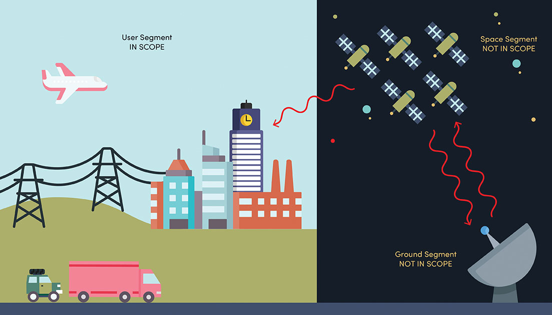
    The letters focus on and endorse the system-of-systems approach outlined in the Department of Transportation’s (DOT) recent report to Congress on the results of its GPS Backup Technology Demonstration. The report found an adequate and robust American PNT system should include space-based L-band signals, low-frequency (LF) and ultra-high-frequency (UHS) signals, and fiber connections between the terrestrial LF and UHF transmitters.

    “Our country depends on GPS for critical infrastructure, and there is an urgent need for resiliency being built into our critical infrastructure. Before the report came out, some of us had different ideas of how the U.S. should go forward,” said Ganesh Pattabiraman, CEO of NextNav. “But the DOT report provided the data to make it very clear that it is a combination of technologies that need to come together to truly enable nationwide backup to GPS, and it was good to see we could get industry alignment on the findings.”

    The letters describe many of the threats to GPS, both natural and malicious; its vulnerabilities; and the dire consequences of disruptions. They go on to state that robust, more reliable PNT is needed for emerging and future systems like E911, 5G, resilient electrical grids, drones and other automated systems.

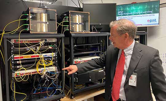
    Monty Johnson, CEO of OPNT, a provider of time-over-fiber services, praised the findings of the DOT report. “The key to resilience and reliability in a system-of-systems is including technologies that deliver the same information using starkly different means. It is hard to imagine a combination of technologies that are more diverse than fiber, satellites, LF and UHF.”

    According to Pattabiraman, the signers of the letter agree that the DOT report made clear that there are mature technologies available today that can address the GPS backup issue. DOT and Congress now have the data to act to enable a much-needed resilient infrastructure for the country.

    Dana A. Goward, president of the non-profit RNT Foundation, agreed. He also observed that deciding on the technologies and congressional funding were important, but only first steps. “The goal of this effort is not to just implement systems,” he said. “it’s to make America safer. Establishing the services quickly and efficiently will be key, as will ensuring they are widely adopted.”

    “Protecting the nation from the consequences of a space-based PNT disruption will require that these systems be accessed and used by a wide variety of users from first responders and delivery services, to all forms of critical infrastructure,” Goward said. “This means the government will need to eliminate as many barriers to adoption as possible. One or more of these alternatives has to be available to every American. And a basic level of service has to be free, just like the GPS utility it is reinforcing. Fortunately, we estimate this can be done relatively inexpensively. It will be only a small fraction of the $1.7B we spent on GPS last year.”

    The alternative to making this relatively modest investment, according to Goward, is unacceptable.

    “There are lots of threats to GPS,” he said. “Take the sun for example. The most recent study I saw estimates a 70% chance solar activity will damage the GPS constellation in the next 30 years and a 20% chance it will destroy a big part of it. And the sun is just one of the threats we face. We can’t keep playing this kind of Russian Roulette with the fate of our nation. Especially when other countries like Russia and China have already taken steps to protect themselves with terrestrial systems.”

    A copy of the letter sent to Senators can be found here, and the one to members of the House of Representatives here.


    Feature image: metamorworks/iStock/Getty Images Plus/Getty Images

  • NIST cybersecurity profile designed  to safeguard critical infrastructure

    NIST cybersecurity profile designed to safeguard critical infrastructure

    NIST's new cybersecurity profile is designed to help mitigate risks to systems that use PNT data, including finance, transportation, energy and other critical infrastructure. While its scope does not include ground- or space-based PNT source signal generators and providers (such as satellites), the profile still covers a wide swath of technologies. (Image: B. Hayes/NIST)
    NIST’s new cybersecurity profile is designed to help mitigate risks to systems that use PNT data, including finance, transportation, energy and other critical infrastructure. While its scope does not include ground- or space-based PNT source signal generators and providers (such as satellites), the profile still covers a wide swath of technologies. (Image: B. Hayes/NIST)

    The National Institute of Standards and Technology (NIST) has drafted guidelines for applying its Cybersecurity Framework to critical technologies such as GPS that use positioning, navigation and timing (PNT) data. Part of a larger NIST effort to safeguard systems that rely on PNT data, these cybersecurity guidelines accompany NIST efforts to provide and test a resilient timekeeping signal that is independent of GPS.

    Formally titled the “Cybersecurity Profile for the Responsible Use of Positioning, Navigation and Timing (PNT) Services (NISTIR 8323),” the new guidelines are designed to help mitigate cybersecurity risks that endanger systems important to national and economic security, including those that underpin modern finance, transportation, energy and additional economic sectors.

    The draft profile is part of NIST’s response to the Feb. 12, 2020, Executive Order on PNT. In early 2020, NIST sought public input regarding the general use of PNT data. The PNT profile will join the growing list of profiles created to help apply the NIST Cybersecurity Framework to particular economic sectors, such as manufacturing, the power grid and the maritime industry. The scope of the profile includes any system, network or other asset that uses PNT services, including systems that receive and rebroadcast PNT data.

    While its scope does not include ground- or space-based source PNT signal generators and providers (such as satellites), the profile still covers a wide swath of technologies. Partly for this reason, NIST’s Jim McCarthy said that it is intended to be a foundational set of guidelines that PNT users can customize.

    “The profile is meant to help a broad set of users address their cybersecurity needs,” said McCarthy, one of the draft’s authors. “Rather than focus on a single economic sector, we designed it to apply to all users of PNT. Agencies and companies can tailor it to their needs based on their particular cybersecurity risk and other sector-specific factors.”

    As directed by the Executive Order, the profile can help organizations accomplish four tasks:

    • identify systems that use PNT data, and/or that propagate this data based on a source signal
    • identify PNT data sources, such as a GPS signal
    • detect disturbance to and manipulation of systems that use PNT services
    • manage the risks that come with responsible use of these PNT services

    “Our premise is that there are organizations that may not realize they are using PNT data, or know how they are using it,” McCarthy said. “Part of our goal is to help them make these connections so they can protect their operations more effectively.”

    The Executive Order also delegates to the Department of Commerce the critical task of providing a source of Coordinated Universal Time (UTC) that is independent of GPS. To this end, NIST also recently conducted initial tests of a special calibration service for companies, utilities or other organizations that wish to receive NIST’s version of the global time standard, UTC(NIST), through commercial fiber-optic cable.

    The service aims to provide a time reference directly traceable to UTC(NIST) with an accuracy of 1 microsecond — good enough for telecom networks, the power grid and financial markets, and thereby boosting the resilience of accurate time distribution and the infrastructure sectors and subsectors that use timing services.

    The initial link is a collaboration between NIST and OPNT, a commercial time-service provider based in Amsterdam, the Netherlands. While the work was led by researchers at NIST’s Boulder, Colorado, campus, the dedicated optical fiber connects the reference time scale at NIST headquarters in Gaithersburg, Maryland, to a facility in McLean, Virginia, that will ultimately serve as the hub for East Coast distribution of timing data.

    OPNT has extended the initial fiber link to Atlanta, Georgia, about 800 kilometers from McLean. Preliminary data suggest that this link will be able to support the requirements of the Executive Order.

  • Open PNT Industry Alliance launched to strengthen national resilience

    Open PNT Industry Alliance launched to strengthen national resilience

    Coalition gives voice to PNT companies seeking open-market approach to backing up GPS/GNSS for critical infrastructure

    Open PNT logoSeveral GNSS and positioning, navigation and timing (PNT) companies have joined forces to create a new lobbying group, the Open PNT Industry Alliance. Founding companies include InfiniDome, Iridium Communications, Jackson Labs Technologies, NAVSYS Corporation, NextNav, OPNT, Orolia, Qulsar, Satelles and Seven Solutions.

    In the United States, the coalition believes the Executive Order on “Strengthening National Resilience Through Responsible Use of Positioning, Navigation, and Timing Services,” issued in February 2020 begins the process for a national alternative PNT policy.

    The Open PNT Industry Alliance also agrees with the U.S. Department of Homeland Security’s findings and recommendations in its “Report on Positioning, Navigation, and Timing (PNT) Backup and Complementary Capabilities to the Global Positioning System (GPS)” submitted to the U.S. Congress in April.

    The report was criticized by some lawmakers for inaccuracies and lack of depth, but several companies whose solutions were referenced in the report defended it, and have now joined in creating this new alliance.

    The alliance expects to support similar initiatives in other countries.

    The coalition is designed to fortify economic and national security by supporting government efforts to accelerate the implementation of backup PNT capabilities for critical infrastructure. Other companies sharing these views are invited to join the alliance.


    The Open PNT Industry Alliance will be introduced in an Orolia PNT Coffee Talk webinar on Thursday, Dec. 17, at 10 a.m. EST.


    A serious problem facing nations around the world is that GPS and other GNSS are susceptible to inadvertent disruptions and deliberate attacks. Such incidents have the potential to impair or incapacitate communications networks, transportation systems, energy production and distribution platforms, financial services operations and other types of critical infrastructure.

    With the scope, complexity and severity of disruptions and attacks evolving continuously, the combination of wide-ranging PNT solutions and emerging technologies offers superior protection to current threats by providing a backup to GPS/GNSS and improving national resilience.

    “Multiple forms of alternative PNT deliver the broadest possible range of operational and performance characteristics to meet the diverse needs of applications across all industry sectors, plus they can better adapt to future threats than a single technology with its inherent vulnerabilities,” said Michael O’Connor, CEO of Satelles. “The mission of the Open PNT Industry Alliance is to promote open-market concepts that preserve industry’s long-term ability to harness its inventive talent to protect GPS/GNSS with multiple solutions that are technologically advanced, commercially viable, and based on a sustainable long-term funding framework.”

    logosThe Open PNT Industry Alliance will share its expertise with governments to aid their efforts to set policies, define regulations, and enact laws that achieve their national resilience objectives while preserving competition in the open market. A principal purpose of the coalition is to stimulate and capitalize on the collective intellect of industry in a collaboration between the public sector and private sector.

    “The ingenuity of the private sector is spurred by competition and public and private investment, and this will drive the emergence of multiple GPS/GNSS alternatives that are cost-effective and evolve according to threat profiles, technological innovations, and market dynamics,” said Jean-Yves Courtois, CEO of Orolia. “Similarly, unbridled innovation will address new and still evolving use cases not supported by GPS/GNSS.”

    The coalition will work closely with governments as they consider plans for regulation of critical infrastructure sectors and funding for alternative PNT. Legislators and policymakers can best pursue national interest through a multi-technology approach to PNT resilience, the coalition stated in a press release. The coalition will advocate for the establishment of a robust and self-sustaining funding framework that allows for the development and adoption of multiple sources of PNT that meet the needs of various sectors and industries.

    “We believe a multi-technology approach to PNT resilience not only meets a more diverse set of critical infrastructure needs but also ensures a more robust approach to security by providing multi-layer resilience,” said Ganesh Pattabiraman, CEO of NextNav. “Delivering alternative PNT capabilities on an equal footing with GPS will require government policies and funding that ensure these solutions are cost-effective for critical infrastructure providers and sustainable over the long term.”

    The Open PNT Industry Alliance website has background on members and policy views, as well as information on how companies can join.

  • DOT holds first GPS backup technology demonstration

    DOT holds first GPS backup technology demonstration

    Notes from DoT GPS Backup Demos – Part I

    Government officials, advisors and congressional staff gathered at NASA’s Langley Research Center on March 13. They were there to discuss the Department of Transportation’s (DoT’s) GPS Backup Technology Demonstration program and view the offerings of six different companies.

    A second event to view and discuss technologies offered by the other five companies in the program is scheduled (as of this writing) for Friday, March 20, at Joint Base Cape Cod, Massachusetts.

    View from Washington, D.C.

    The day began with remarks by Karen Van Dyke from the U.S. Department of Transportation, as well as remarks prepared by Colonel Joseph Frankino, deputy director of the National Coordination Office, a multi-agency staff that supports the National Space-Based Positioning, Navigation, and Timing (PNT) Executive Committee, whose members were unable to attend.

    Van Dyke provided an overview of the program and pointed out the increasing importance of resilient PNT. As just one example, improvements in autonomy and self-driving cars are entirely dependent upon consumers having confidence in the entire system, much of which is underpinned by PNT.

    Col. Frankino’s remarks reflected the Defense Department’s commitment to and support of DoT’s resilient PNT efforts. He pointed out that the nation’s military depends upon the defense industrial base, which depends upon uninterrupted PNT.

    Volpe Transportation Systems Center

    The technology demonstration effort is being coordinated by Andrew Hansen from DoT’s Volpe Center. Dr. Hansen pointed out that the ongoing effort, the analysis and assessment of which is expected to be concluded in May, is a series of demonstrations vice tests. This means that the companies involved were showing what their systems could do, vice being measured against set criteria.

    He also mentioned that the maturity of all the systems involved seems to have improved significantly over the last year. All are at Technical Readiness Level 6 or better. Also, that things so far had gone very smoothly with no need for any “re-dos.”

    GPS and a cesium clock were being used as reference standards for the demos. Two of the systems, NextNav and Skyhook, were also demonstrated on a drone at Langley’s 150 acre open air site.

    Report and Transparency

    Data from the demos is not proprietary and belongs to the government which intends to make “as much of it available as possible.” DoT representatives mentioned several times their desire for maximum transparency.

    Admiral (ret.) Thad Allen (left), chair of the National PNT Advisory Board, was among the attendees learning about DoT’s GPS Backup Technology Demonstration project at NASA’s Langley Research Center. (Photo: RNT Foundation)
    Admiral (ret.) Thad Allen (left), chair of the National PNT Advisory Board, was among the attendees learning about DoT’s GPS Backup Technology Demonstration project at NASA’s Langley Research Center. (Photo: RNT Foundation)

    Attendee Observations

    After a day of viewing and discussing the six different technologies with their vendors, the group reconvened to offer feedback. All agreed the day was very worthwhile and complemented DoT and NASA on the event.

    Kicking off the discussion, the DoT hosts remarked that the department is fully committed to GPS and its modernization. That said, there is broad recognition of the importance of other PNT systems. This is evidenced by the recent White House Executive Order on PNT.

    Also, that there is no single solution that will fill the PNT needs of everyone. In fact, GPS does not serve the PNT needs of everyone. The need across sectors for a wide variety of sources to “backup” GPS is why the demonstration project includes some systems that only provide time, or only positioning.

    Feedback from attendees included:

    • The reason for this project is that we have a 20th-century GPS and 21st-century threats. New technologies need to be examined for vulnerabilities. Security must be “baked in” from the beginning. Moderators commented that the DHS Conformance Framework was one of the tools that would help with this.
    • Rural and other underserved areas (such as wilderness, remote transportation networks, maritime) need PNT and should be a part of the government calculus.
    • Many systems depend upon infrastructure provided by others versus being self-sufficient.
    • In the view of many in Congress, it is good to see the demos going well. Overall, though, things are about two years late. Members and staff are very interested in when there will be an RFP and schedule for implementing the timing system mandated by the National Timing Resilience and Security Act of 2018.
    Monty Johnson of OPNT demonstrates precise time transfer through 100 kilometers of spooled fiber-optic cable. (Photo: RNT Foundation)
    Monty Johnson of the company OPNT demonstrates precise time transfer through 100 kilometers of spooled fiber-optic cable. (Photo: RNT Foundation)

    Systems Demonstrated at NASA Langley

    During the course of the day, attendees had the opportunity to interact with representatives from the following companies and their systems.

    Vendor Service Technology
    TRX Positioning Inertial Measurement Units
    NextNav Positioning & Timing Metropolitan Beacons
    Skyhook Positioning WiFi, cell ranging, very large proprietary database of site locations
    Echo Ridge Positioning & Timing Uses Global Star LEO constellation of 24
    OPNT Timing Timing Fiber & White Rabbit protocol
    Seven Solutions Timing Timing Fiber & White Rabbit protocol


  • GPS backup demonstration projects explained

    GPS backup demonstration projects explained

    The U.S. Department of Transportation awarded contracts to 11 companies to demonstrate their technologies’ ability to act as a backup for GPS.

    We wanted to know a bit more about what each of them were going to demonstrate, so we asked each for an explanation. Most provided just that, so much of what appears here is in their own words. A couple of companies sent us a whole lot more than 100 words and two did not respond. For those, we did our best with the materials they sent us and other publicly available materials.

    Wi-Fi, Cellular, Ultra-Wideband

    PhasorLab plans to demonstrate its Hyper Sync Net (HSN) technology as a backup to GPS-based PNT solutions. HSN is a self-organizing mobile mesh network capable of maintaining high-precision time (<<1 ns) and frequency (<<1 ppb) synchronization throughout the whole network as well as an instantaneous 3D locational map of the whole mesh network requiring as little as a single master reference node.

    The HSN can be deployed either as a set of fixed reference nodes providing time and positioning references to other mobile UE clients, which is like a terrestrial version of GPS, or as a private ad-hoc mobile mesh network where all members are expected to be mobile.

    Skyhook Technology’s system is powered by an immense database — created and maintained by Skyhook — that contains more than five billion geolocated access points and 200 million cell base station IDs, enabling it to accurately locate phones and devices worldwide. The user is not required to be connected to a Wi-Fi network for the system to work. The scan will simply detect Wi-Fi access points in the local area based on signals sent periodically (or on demand) according to the IEEE 802.11 specifications. Many devices will acquire information on as many as 100 access points in the surrounding area. Skyhook’s Wi-Fi positioning system (WPS) will compute an estimated end-user location based on each of the signal sources independently, and compute an optimal hybrid location estimate from all sources.

    Fiber/Network

    OPNT’s Global Terrestrial Timing Service (GTTS) provides GPS-independent timing-as-a-service over global fiber-based networks. Trading off cost versus service-level agreement (SLA)-backed accuracy, standard network connectivity offerings and bidirectional fibers are combined to meet application needs. As will be demonstrated with simulations of National Institute of Standards and Technology (NIST) and the two U.S. Naval Observatory (USNO) clocks, OPNT’s fully redundant solution receives its core Coordinated Universal Time (UTC) timing directly from the non-maskable interrupts (NMIs).

    The demonstration will include sub-nanosecond stability with fault detection and glitchless recovery. Using the precision-timed fiber base, OPNT will also demonstrate precision monitoring of wireless signals with continuous, real-time corrections to keep the wireless transmissions and its local timing source in sync.

    Seven Solutions’ core technology is called White Rabbit and was born at CERN. In this demonstration, Seven Solutions plans to showcase the performance of this technology, both on local and wide-area deployments, and explain the capabilities in terms of interoperability (integrating multiple synchronization technologies, i.e. IEEE 1588 PTP, NTP, PPS, 10-MHz clocks), scalability and resiliency. The goal is to provide a reference technology that can provide very stable time references over fiber in GPS-denied scenarios as a backup source or to complement other PNT solutions that need timing distribution at their core.

    eLoran

    Hellen Systems’ team said it is excited by its recent contract award to perform a GPS back-up demonstration for the Department of Transportation. Its team plans to demonstrate advanced eLoran technologies and offer resilient PNT services. Its next-generation solution will include a solid-state eLoran transmitter from Continental Electronics Corp. integrated with advanced timing and frequency products from Microsemi, a Microchip company. Hellen Systems also plans to deploy its proprietary receiver and reference systems developed by Microsemi.

    Hellen Systems and program integrator L3Harris will manage the demonstration, with Booz Allen Hamilton providing technical and engineering leadership.

    UrsaNav supplies eLoran, LFPhoenix and low-frequency technology for very wide-area, GPS-independent, PNT data and frequency services. UrsaNav was selected by the Volpe Center to demonstrate wide-area UTC time synchronization and distribution utilizing the former Loran site in Wildwood, New Jersey. UrsaNav will provide innovative new eLoran technology at the site in Wildwood to broadcast a UTC-synchronized eLoran signal. The demonstration will be conducted at one of the Volpe Center demonstration sites at Joint Base Cape Cod in Massachusetts or the Langley Research Center in Langley, Virginia. Either site can be utilized in the demonstration as eLoran signal transmissions from the Wildwood site can easily cover 700 miles or more.

    Serco recently acquired Alion’s Naval Systems Business unit. This included a group working in New London, Connecticut, that has previously worked with and published on eLoran. While we did not get a response from Serco to our inquiry, eLoran is likely the technology the company will demonstrate.

    Satellite

    Globalstar-Echo Ridge’s system is based on Augmented Positioning System (APS) technology that uses ordinary signals from communications satellites (not special positioning/navigation signals, such as those from GPS satellites) to produce accurate position and timing information in compatible user devices. No new infrastructure is needed; Globalstar’s constellation of 24 low-Earth-orbit (LEO) satellites and Echo Ridge software and compatible devices at the user end provide the building blocks for the APS-based system. APS technology has been successfully demonstrated in diverse environments and incorporates multiple features to assure accurate PNT information under circumstances that can challenge or disable GPS/GNSS technology.

    Satelles provides unique timing and location solutions delivered over the Iridium constellation of 66 LEO satellites. These timing and location signals are available anywhere on Earth without the need for local infrastructure, making the system perfect for complementing GPS and other location-based technologies.

    Unlike standard GPS, these high-power signals can reach into many building structures. Most importantly, Satelles has customized the Iridium signal-in-space to provide a location-specific signature that can reliably prove (or authenticate) the location of a mobile device or other equipment, while being virtually impervious to spoofing and other attacks.

    TRX Systems’ NEON Personnel Tracker provides ubiquitous 3D location, tracking and mapping. (Screenshot: TRX Systems)
    TRX Systems’ NEON Personnel Tracker provides ubiquitous 3D location, tracking and mapping. (Screenshot: TRX Systems)

    Other

    TRX Systems is the developer of NEON GPS-denied location solutions, delivering 3D location and mapping for dismount personnel where GPS is not available or is unreliable — including indoors, underground, in dense urban areas, and where GPS is found to be erroneous. NEON delivers ubiquitous, low-cost, GPS-denied location by using advanced sensor fusion, ranging and patented dynamic mapping algorithms that improve safety and situational awareness for military, public safety and industrial personnel.

    NextNav’s Metropolitan Beacon System (MBS) is a 3GPP-compliant, terrestrial network of long-range broadcast beacons, transmitting a “GPS-like” signal in licensed spectrum in the sub-GHz range. The combination of an on-board atomic clock and the ability to self-synchronize allows the system to operate independent of GPS and provide full PNT services in its footprint. The ability to integrate the MBS signal in mass-market GPS and LTE chipsets can provide a seamless ability to provide full PNT services in the presence and absence of GPS. Because of its terrestrial nature, MBS is able to work indoors, in urban environments and outdoors; for barometer-equipped devices, MBS also enables floor-level altitude determination.