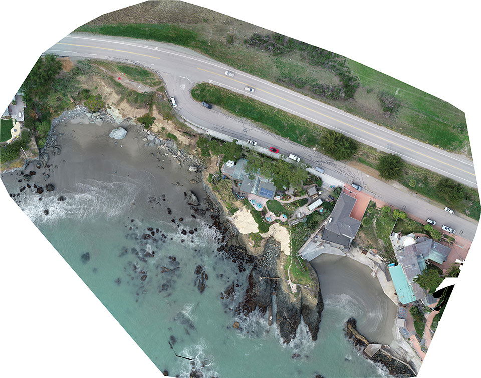
Cliff surveys are traditionally performed with fixed-wing aircraft that collect nadir photos. However, a photogrammetry company accurately triangulated oblique images and mapped them in 3D stereo, developing a new technique in the process.
The erosion survey — along Pacific Coast Highway 1 in Cayucos, California — required imaging the side of the cliff to produce a precise orthomosaic and topographic map of its structure and integrity. The project required a 0.5-inch orthomosaic, a 1.2-inch 3D topographic contour map and a vector-based digital terrain model accurate to 1.2 inches.
Surveyor Paul Reichardt and Robert Lafica, owner of Central Coast Aerial Mapping, placed ground control points around the property and beach, and then used a Trimble R8 GNSS receiver to measure their positions to within 0.04-foot accuracy. They also established four checkpoints for quality control in the photo triangulation process. The R8 and a Trimble 5600 total station were used to collect property corners and top-of-surface elevations to integrate into the 3D topographic map.
At an altitude of 131 feet, the UAS covered the site from both nadir and oblique camera angles in nine passes, collecting 158 photos at an average ground sample distance of 0.5 inches. To capture the cliff side, Lafica flew the UAS about 90 feet from its face and angled the camera at 40 degrees.
The photos and position data were loaded into Trimble’s Inpho UASMaster photogrammetric software to automatically triangulate the images. The software pinpointed 6,368 common features with multiple connections to match images to each other. After initial triangulation, precise coordinates were attached to each control point, a final triangulation was completed to create the maps, and a new technique for mapping cliff faces was born.
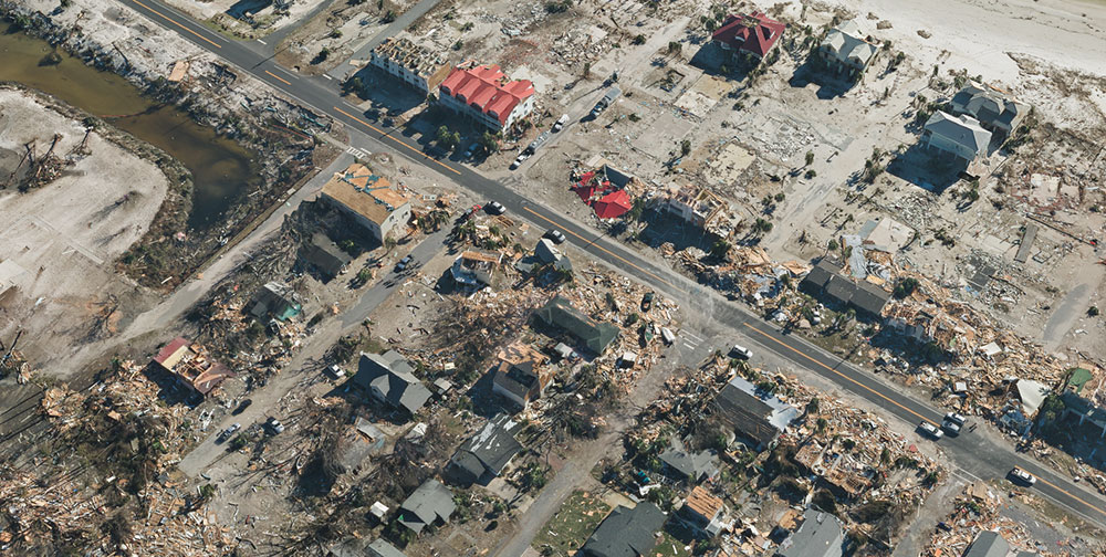
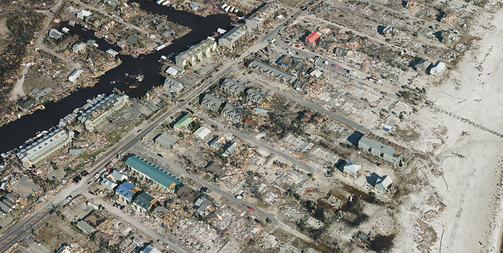
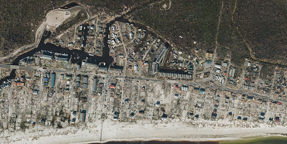
Correlator3D was used to process large format imagery collected by Midwest over Mexico Beach, Florida. (Image: SimActive)
SimActive Inc., developer of photogrammetry software Correlator3D, has partnered with Midwest Aerial to perform damage assessments of Hurricane Michael.
Correlator3D was used to process large format imagery collected by Midwest over Mexico Beach, Florida. The joint effort resulted in highly precise geospatial data, including a digital surface model (DSM), an orthomosaic and a 3D model, the company said.
“This is a terrible disaster for the people affected and we hope they can benefit from geospatial technologies available,” said Philippe Simard, president of SimActive.
The gallery below shows samples of the imagery collected.
SimActive partnered with Midwest Aerial to perform damage assessment of Hurricane Michael. (Photo: SimActive)
Correlator3D was used to process large format imagery collected by Midwest over Mexico Beach, Florida. (Image: SimActive)
Aerial imagery of the devastation from Hurricane Michael in Mexico Beach, Florida. (Image: SimActive)
SimActive’s Correlator3D is a patented end-to-end photogrammetry solution for the generation of high-quality geospatial data from satellite and aerial imagery, including UAVs. Correlator3D performs aerial triangulation and produces dense DSM, digital terrain models, point clouds, orthomosaics, 3D models and vectorized 3D features.
Powered by GPU technology and multi-core CPUs, Correlator3D ensures high processing speed to support rapid production of large datasets, the company added.
Midwest Aerial Photography focuses on acquiring high-quality aerial imagery and companion data in support of photogrammetric mapping projects across the United States and Canada. Midwest partners and clients include federal, state and local government agencies, as well as photogrammetric firms and architectural and engineering companies.
EuroTube is Europe’s first testing ground for high-speed vacuum maglev transportation.
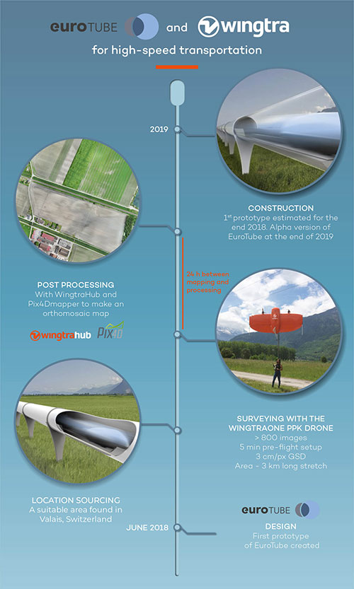
In May, a WingtraOne drone conducted a topographic survey of a construction site where a EuroTube vacuum high-speed test track will be built.
The futuristic project is the European answer to its American counterpart Hyperloop of the SpaceX and Elon Musk fame. The EuroTube project plans to provide a 3-kilometer-long vacuum tube to developers of pod technologies for testing.
The Eurotube test infrastructure for high-speed vacuum transportation will provide an environment free of air resistance to test “pods”, or cars, that can be accelerated to speeds as high as the Boeing 747 in flight. (Photo: EuroTube)
The project proved to be surprisingly challenging from the very beginning. First, the team had to find a long, flat stretch of land for EuroTube’s construction in Switzerland, a country famous for its mountains.
And just as the right location was found in the canton of Valais, another challenge came along. How to survey such a complicated site surrounded with mountains, water bodies, forests and railway tracks? Luckily, the fellow Swiss company Wingtra already had a solution — the vertical-take-off-and-landing (VTOL) drone WingtraOne.
After spending months in research and development of prototypes, the team at EuroTube selected the stretch of land in the Valais region of Switzerland as its candidate location. The chosen construction site is located next to railways tracks. A few water bodies, forests and ditches flank the other side of the construction site, making available a mere 3-meter-wide piece of land for take-off and landing of the drone.
Fortunately, the WingtraOne’s VTOL capabilities were designed with exactly these kind of constraints. But why choose such a peculiar construction site in the first place?
Bringing Europe’s transportation system to 21st century
The answer lies in the technology behind the EuroTube itself. One of the main limitations in speeding objects on ground is the high air resistance, also called drag (drag is a type of friction force acting opposite to the relative motion of any object). By maintaining a low-pressure environment or even a vacuum, this air resistance can be lowered drastically, and hence objects can be accelerated to high speeds.
Technologies such as the EuroTube provide this vacuum environment inside a long tube. Within such tubes, cars called “pods” can be accelerated to speeds as high as 800 km/h, meaning a journey between Zurich and Paris, which currently takes 4 to 6 hours, would be reduced to a mere half an hour. This is the vision driving the EuroTube project, which will provide a 3-kilometer-long vacuum tube to developers of pod technologies for testing.
Aerial surveying of the construction site
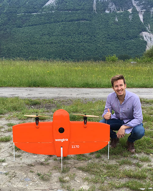
Gerard Güell, the construction director of EuroTube, at the construction site with the WingtraOne. (Photo: Wingtra)
Before the construction of the tube could begin, however, the EuroTube team needed to survey the construction site. Looking at solutions that would cut time and cost, Sascha Mark, the technical director at the EuroTube project, reached out to Wingtra in early May.
A partnership between Wingtra and EurtoTube was quickly formed where Wingtra would provide the WingtraOne as well as conduct the surveyof the construction site.
“For a cutting-edge research project involving significant infrastructure, time is of crucial importance,” Mark said. “We were looking at surveying solutions that can provide the dataset required for a construction site quickly without compromising on the accuracy. From this perspective, WingtraOne looked like a viable prospect.”
The survey was conducted on May 21 when Gerard Güell, the construction director at EuroTube, met Adyasha Dash from Wingtra on site. To survey the area quickly with high accuracy, a WingtraOne equipped with an RX1RII camera and post-processed kinematics (PPK) was chosen. As the survey required flights over a straight, flat piece of land, flight planning was done on site, and took less than 5 minutes for the setup.
The wind on site ranged from 2 m/s to 5 m/s. After letting the flight planning app WingtraPilot run a host of automatic pre-flight checks, the drone started its flight to collect aerial imagery at a ground sampling distance (GSD) of 3 cm/px. At the end of two consecutive flights taking less than an hour in total, the drone had collected a little more than 800 individual images.
“It was nearly effortless to conduct the aerial surveying with the WingtraOne,” Güell said. “All we had to do was to walk to the take-off area, double-check the survey area we wanted to cover on the flight planning app, and hit go.”
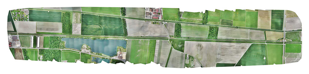
Final orthomosaic generated by the images collected by the WingtraOne: the 3-km long Eurotube will be constructed along the indicated area. (Image: Wingtra)
From aerial imagery to point cloud
Infographic: Wingtra
After two flights, the images were pre-processed with WingtraHub, a desktop app, to add geographical identification metadata to the images. PPK processing was also done in this step. The base file for PPK processing was obtained from Swisstopo, which monitors GNSS receivers at 30 permanent locations in Switzerland. These receivers form the modern-day reference points for positioning and surveying, and help enhance the geolocation information of the images in conjunction with the flight data (hence the name, post-processed kinematics). It took a little more than half an hour to pre-process the entire dataset.
The images with their accurate geolocation information were then uploaded to Pix4Dmapper to generate a point cloud of the site. All in all, it took less than 24 hours to go from data collection to point-cloud generation, without compromising on the quality of survey itself.
“We are pleased to say that the dataset gathered by the WingtraOne was precise enough to let the engineering office begin planning construction,” Mark said. “The generated point cloud has a vertical accuracy of 10 centimeters and horizontal accuracy of 3 centimeters. Thanks to the WingtraOne, we are now well on track on our timeline to begin construction.”
According to EuroTube’s scheduled timeline, a shorter prototype of the tube will be completed at the end of this year, and an alpha tube at the end of 2019. European research and development teams across institutes and universities can then start testing pod technologies to make ultra-high speed transportation systems a reality.
Adyasha Dash works as a software developer at Wingtra, where she focuses on developing safe flight control and planning algorithms. When she is not tinkering with drones, you can find her writing about the ethics of artificial intelligence and human machine interactions.
New users can upload their first UAV, satellite or aerial image project to obtain digital surface model (DSM), digital terrain model (DTM), point cloud and orthomosaic outputs.
Along with optimal results, users also receive tailored feedback, recommendations and training from SimActive experts.
The service requires no obligation, and is based on Correlator3D software, building on more than a decade of innovation on computer vision algorithms, a subfield of artificial intelligence. Quick turnaround is also possible due to the speed of the software and extensive use of GPU.
“Our new offer is unique to get the best possible results from the very first project onward,” said Philippe Simard, president of SimActive. “Following this, users are trained with industry-leading technology, custom advice and necessary knowledge for successful mapping.”
The Lehmann L-A 300 drone is designed for mapping.
Lehmann Aviation has rolled out a new version of its OperationCenter, a flight preparation and mission control software program for automatic orthomosaic flights. Also, the company dropped the price for its L-A 300 fully automatic professional drone designed for mapping, because of an uptick in demand and increased production.
The new version of Lehmann OpsCenter, designed for Windows 8.1 tablets and PCs, now includes:
New mission control functions (holding, auto return, non-flying zone)
Terrain awareness during mission preparation, for safer flights in mountain areas
Integration with Google Earth for flight preparation and replay
New easier upgrade and update procedures directly through the web
New options to manage new cameras (GoPro, Canon) for orthomosaics and surveying.
Priced at $2,890, the L-A 300 is a professional drone designed for accurate mapping and digital elevation models (DEMs) that works with the GoPro, Canon S110 and multispectral cameras. It flies automatically for 30 to 45 minutes at a trajectory pre-prepared by the user in the OpsCenter (the range is 18.5 miles).
“In 2014 we significantly increased our production volume thanks to numerous orders from all around the world,” said Benjamin Lehmann, founder and CEO of Lehmann Aviation. “This enabled us to reduce the price for our best-sellers, all L-A-series drones. We also made the decision to follow our strategy of offering really high-tech aerial solutions at fair prices.”