Satellites NTS-1, 2 and 3. (Illustration: Lt. Jacob Lutz, AFRL Space Vehicles Directorate)
Just last month we celebrated the kickoff of the GPS III campaign, reporting on the launch of the first space vehicle of that generation in the closing days of 2018. A new era had begun, heralded by a rocket’s blazing path, bearing aloft a new “lighthouse in the sky serving all humankind.”
Turn around and — whoa! Where did all these other new PNT satellites come from?
We attempt to chronicle them all in this issue, though I’m not sure we haven’t still missed some.
For years we’ve been talking about the Iridium constellation, a low-Earth orbit telecommunication network that can also deliver timing services to improve accuracy, and signal acquisition in urban environments. Were it not for the fact that 10 more of its satellites just launched in January, bringing the total of its second-generation NEXT constellation to 75, this would practically qualify as old news.
But let’s move on to the real new news. NTS-3 is the new kid on the block most closely related to the GPS family. In fact, integrally a part of it. This third Navigation Technology Satellite will go even beyond GPS III — whose capabilities, mark you, are not yet online — to investigate new experimental antennas, flexible and secure signals, increased automation and use of commercial ground assets.
Learn about 72 nanosatellites of the Spire constellation piggybacking on Galileo signals to offer GNSS radio occultation products for the weather community. This may not be exactly direct-to-user PNT, but it’s a derivative.
Finally, absorb the latest on Hawkeye 360 formation-flying Pathfinders, designed to detect and geolocate radio frequency (RF) signals, and use the data in search-and-rescue as well as commercial maritime operations.
Don’t stop there! Read about Planet, the breadloaf satellites, current population 300 with more coming, beaming down 1.2 million high-resolution Earthly images per day, useful for agriculture, defense, mapping and GIS, and a few other industries.
If a group of satellites is a constellation, what do you call a group of constellations? If we are to follow astronomy’s lead, I’ve just learned that the proper technical term is an asterism. However, I think galaxy will be easier to handle.
GNSS and PNT markets continue changing, sometimes very rapidly. No news there. Technology advances relentlessly, opening up new application areas and new price points as it goes.
The market for inertial navigation systems (INS), a subset of that PNT universe, is no exception. The number of available options in inertial has grown substantially. Micro-electrical-mechanical systems (MEMS) sensors lead the charge. Smaller, lighter, lower power and less expensive than previous inertial measurement units, they are truly changing the game and exploding past their previously limited deployment.
So much so that I now need to find a MEMS expert to join our editorial board, advise me on article selection, and attend an ever-widening spectrum of PNT-relevant conferences on behalf of this magazine.
That’s not the only smaller, faster, lighter, cheaper advance warping the speed of change in PNT. Our reporter Robin Wrinn got a look at the 33rd Annual Space Symposium at the ways 3D printing is changing how GPS satellites are put together. I had to rub my eyes when I read her account. Yes, GPS satellites. The column in The System of Systems (page 10) touches only lightly upon this phenomenon. I had to edit all the rest out as we are so short of space in this issue. But go online, where space no longer constrains us, for a fuller account and startling photos.
If this trend goes on much longer, I’ll need a 3D printing expert on the editorial board as well. Indeed, we gave some consideration a few years back to bringing 3D printing “under the umbrella,” so to speak, inside the magically expanding tent — like something out of Harry Potter — that encloses all the technologies we must cover, just to keep up with you folks.
I sense something else lurking about, awaiting an entrance. And for this I’ll really need an expert adviser. I don’t even know what to call it. Somehow it combines virtual reality and gamification. Yes, really. Games are about to begin playing a role in PNT. First in mapping, through the visualization of data; this is explored in our May Defense PNT & Geointelligence Insidernewsletter column.
Gamification is “the application of game-design elements and game principles in non-game contexts.” To what purpose? To improve productivity, of course. Though we may call it accuracy, or availability, or robustness in our realm. It begins with crowdsourcing, probably. Though I feel the ice getting thinner, the limb weaker beneath me as I climb out upon it. Think I’ll stop now.
“It’s always been time.” That was the first answer out of the gate, given in Session 3 of the Munich Satellite Navigation Summit last month. Dominic Hayes, Spectrum Management and Policy for Galileo, EGNOS and Copernicus at the European Commission, was prompt off the mark. “GNSS is so good, so easy and so cheap, other means are falling out of use.” Therein lies the peril.
That emotion was seconded by every other speaker on the panel. But of course. Virtually no one in the GNSS community at large, let alone those attending the Munich Summit, thinks otherwise.
Thinking and action do not go hand-in-hand, however. GNSS back-up resembles the weather, in that everybody talks about it, yet … yet … nothing changes. As long ago as 2015, the U.S. Department of Transportation and the Deputy Secretary of Defense made noises about building an alternative system to GPS in case of disruption, and certainly there were hand gestures aplenty prior to that.
Do we have a back-up, presently?
No. The U.S. government is in such a hurry to protect its borders that it gives scant thought to protecting what’s inside: critical infrastructure.
Is it time?
It’s always been time.
Things are more like they are now than they ever have been, what with the cloud and all. We’re storing so much data in the cloud, with more and more of the world’s operations every day keyed to and driven by distributed database processing, in huge data servers around the world. This is according to John Fischer of Spectracom, who is in a position to know. Precise timing at the micro- and nanosecond level plays a huge role in connecting and synchronizing users. But again, he was preaching to the choir.
Guy Buesnel from Spirent Federal reiterated the new threat sprung from Pokémon Go: a community of gamers and enthusiastic coders, generating homespun spoofing mechanisms for fun. They will soon realize, if they haven’t already, that there’s profit to be made there as well.
“We have become too reliant on GNSS today,” stated Buesnel. Most interference warnings are low level, but 3 to 4 percent are serious enough to disrupt receiver operations. And that still means you have to take action in response. He stressed the importance of a balanced systems engineering approach, and invoked Brad Parkinson’s PTA mantra: protect, toughen and augment.
Hayes called for a European Radio Navigation Plan, similar to the U.S. Federal Radio Navigation Plan (FRNP). Later, in response to a follow-up question, he acknowledged that “radio” need not be part of all encompassed systems; the proposed name is a legacy of modeling after the FRNP.
So far, the FRNP itself is nothing but a model, a little architectural construct of what someday might be. But nothing’s been built, that particular someday is no closer, and meanwhile the threats loom larger.
It’s funny sometimes how things work out. I had just been preparing to take up in this column an issue raised last September at the ION-GNSS+ Plenary Session. Literally at the very moment I set pen to paper, notice of an extremely positive response to the problem arrived in my inbox. Hypercoincidental as it may be, market forces can and do work in mysterious ways, inexorably driving forward progress.
The issue arose during “lightning talks” as track chairs gave brief overviews of material to be presented in the following days. That’s when Paul McBurney tackled the gorillas.
A former eRide co-founder and now CEO of GopherHush Corp., a location analytics company, he chaired the Mass Market Application track. As he described market players — GNSS chip providers, sensor providers, indoor location providers, app providers and operating system (OS) providers — he made this statement: “The OS providers are the 800-pound gorillas that we have a hard time getting into this room. They have to support their fusion layers over a wide range of handsets and devices. They often end up competing with the apps makers they enable.”
A couple of those gorillas were in the room, in fact, and at least one more prominent GNSS figure has since joined their band. We’re talking Google and Apple, in case you hadn’t guessed.
McBurney’s point, as he later elaborated to me: “The OS manufacturers are really driving/owning the requirements/feature set of the mass-market chip providers. If they wanted carrier phase to drive RTK in the OS, everyone would have to step up to provide it, and these chip makers would lose their advantage in providing that to higher paying customers. If chip makers aren’t able to play, they are relegated to the crumbs of the rest of the market. Even car navigation is barely 1/10th of mobile. OS providers also dictate where/how sensor fusion/indoor location is performed. Sensor chip providers are in the same boat.”
I’d been thinking on and off about this situation since September, and as said was about to trumpet a call for the gorillas to come down out of the mist — or wherever they reside — to collaboratively and constructively join the PNT community. That’s when this message popped in through the electronic transom:
“Google I/O was this week and we announced we will open pseudoranges (raw GPS measurements) to application developers. If you want, I can do a blog post for you on this for the next magazine.”
Well, you bet I do! Look for it in the July issue. This is big news indeed. Check the website for a bit of elaboration in the meantime, and for the link to a YouTube video of the Google I/O announcement.
McBurney has further thoughts on this development, and you’ll see some of those next month as well. For now, he opines, “I was thinking that Google opening up pseudoranges shows that, while they wield huge power, they still understand the advantage of being open. A clear distinction from Apple.”
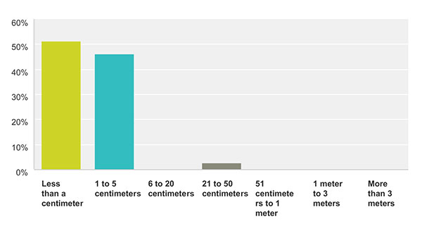
How accurate is good enough for the majority of your market sector? This chart show the answers from those who identified themselves as members of the survey and high-precision community. For more results from this and other sectors, see the 2015 State of the GNSS Industry Report.
Memory fails as to who first said “Accuracy is addictive.” Or perhaps it’s my knowledge base that is deficient. At any rate, I’ll gladly publish documented evidence from anyone who can show the earliest — print or audio — expression of that dictum. It continues to hold as true for this industry as Moore’s Law does for computer technology as a whole.
We have seen the gradual tightening of accuracy requirements across all sectors of the positioning, navigation and timing (PNT) community with each successive iteration of our State of the GNSS Industry Survey, now in its fourth year. This is the first time we have seen it cross the 1-centimeter line. Not in capability; sub-centimeter capability has been available for some time. But now that level of performance is the minimum acceptable “good enough” for more respondents in the survey and high-precision sector than any lesser degree of accuracy; in fact, greater than all other ranges combined. These addicts form the new majority. Their preferences and their behaviors will rule our world.
Other sectors will presumably answer likewise in coming years, following the trail blazed by the high-precision pioneers.
We have crossed the Rubicon. Unlike other obsessive behaviors, there is no going back in our case. This path is a one-way road to — well, not to the various hells entailed by other addictions — but to the promised land of always-on, always-true, near-perfect provision of positioning.
Let’s not kid ourselves, however. The perfect world does not exist. The closer we get to millimetric accuracy, the more obstacles we find in our way. Indoor continuity aka ubiquity, jamming, spoofing, hacking, budget cutbacks, slides to the right — this list will surely grow.
The more acute our addiction, the lower our tolerance for less-than-total fulfillment.
Of it all. Of the broad expanse of the world and all its inhabitants, its layers, its depths and heights, the atmospheric mantle in which it wraps itself, its floating mountains of ice and its solid soaring peaks of rock and snow, its savage predators, and all its shades of human endeavor.
Every August we marvel at the many applications of global positioning science, at real-world instances of hardware and software in the service of humankind and of Gaia itself.
Eleven months out of the year we chronicle the business and technology of GNSS, as it says on the cover. Eleven months we busy ourselves with explorations of R&D, of novel concepts and experimental tests, of integration and augmentation and propagation and limitation and innovation; of algorithms and systems, theorems and OEMs, robotics and aeronautics, UAVs and degrees, integrity and capability and availability and mobility and connectivity and security, functionality and ambiguity and compatibility and velocity and linearity.
Every once in a while we have to stop amid all this admittedly somewhat abstruse science and ask ourselves: “GNSS — what is it good for?”
Answers are never lacking. Since Ivan Getting originated the idea of lighthouses in the sky for humanity in the 1960s, inventors have put forward new solutions for vexing problems — sometimes solutions for what we didn’t know was a problem, but upon investigation turns out to have a profitable resolution. Witness the stories in this issue, from sharks to space, from mountaintops to multi-sensor navigation under interference or heavy canopy.
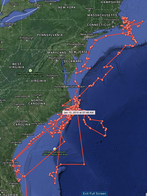
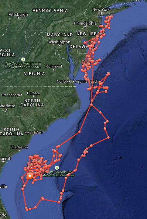
Now about those sharks. In case you were wondering whether Katharine or Mary Lee might have been culpable in the seven shark bitings off North Carolina during May and June — they were not. The maps here and their GPS timelogs give both solid alibis for all the attacks in question.
Katharine’s cruising over the past year.Mary Lee’s meandering over same time.
Sometimes you have to stop and, yes, smell the roses, but also survey just how far you’ve come, where you stand at this actual moment, and what directions hold the most promise for the future. When you’re moving as fast as the GNSS and PNT industries do, a periodic pause to assess becomes even more vital.
That’s why we conduct the annual State of the Industry Survey, which generates the State of the Industry Report.
Your part in this, the Survey, starts July 15, when the online survey will be posted at env-gpsworld-integration.kinsta.cloud/State15, and remain at that link until August 10.
Our part, the Report of your filings, will appear in the September issue.
Past State of the Industry Reports have borne such insights as these.
September 2012. “Careful optimism appears to be the watchword for the GNSS industry as we head into the next year, tempered with the reality that a full economic recovery has not yet arrived; 65 percent of respondents described the market for GNSS products and services as enjoying either moderate growth or strong growth. ‘With the economy in the state it is in, competition is very tight. That is all right, it keeps our pencils sharp,’ wrote one industry veteran.”
September 2013. After the passage of one year, 69 percent described the market for products and services in their sector as either relatively healthy or very healthy. That’s what’s known in economic circles as “a modest increase.”
Dominating executives’ and managers’ awareness as a key issue shaping the future that year were three candidates, according to John Pottle of Spirent Communications. “Vulnerability of GNSS signals, the flurry of activity following the release of the BeiDou system ICD, and the continuing indoor navigation challenge. Whatever your viewpoint, one thing is clear: there remain plenty of challenges for us all, as indusry insiders, to solve over the coming years.”
October 2014. With another 13 months under our collective belt, we had not fully mastered any of those top three challenges — but we had logged significant progress. Jamming, both intentional and unintentional, along with spoofing led all concerns for 28 percent of survey respondents, and if “constellation health” were added to those worries, fully half of our experts — meaning you — deemed this the industry “issue of the year.” Meanwhile, the percentage of those finding moderate to strong growth in their sector had risen to 74.
Michael Ritter of NovAtel spoke for many when he wrote, “Ultimately, GNSS itself will no longer be enough. Ubiquitous positioining requires multi-sensor fusion that can exponentially increase availability.” And he revealed that NovAtel spends 30 percent of its annual revenue on research and development.
The Future Begins Now. Only you, in your collective wisdom, can tell us where we stand and where we’re headed. I encourage you to help us compile the State of the Industry by filling out a relatively quick online questionnaire. Look for it to be posted on July 15.
It is heartening to see a burgeoning constellation and its operators move on from doubt to certainty, as Galileo prepares for fuller operational capability and the expectations that scope elicits.
To pick up the thread from last month’s column covering keynote speeches at the European Navigation Conference: plenaries subsequent to the opening session focused respectively on “GNSS for Aeronautical Applications: from GPS to Multi-Constellation with Galileo,” and “GNSS Resilience for Terrestrial & Naval Applications.”
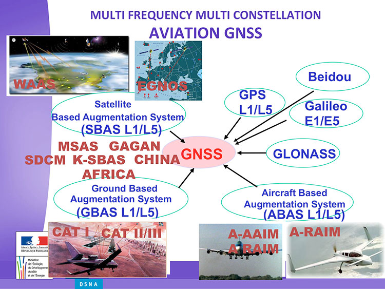
Avionics. Benoit Roturier, GNSS and Performance-Based Navigation program head for the French air traffic control agency, Direction des Services de la Navigation Aérienne (DSNA), reviewed the rather complex assembly of air navigation systems gradually coming together. Not quite — or not nearly — a system of systems, as I understand it, more a conglomeration of systems.
Slide from Benoit Roturier’s presentation on behalf of the French air traffic control agency. (Courtesy of Benoit Roturier)
Multi-constellation GNSS combos, with added context from satellite-based augmentation systems (SBAS), target provision of performance-based navigation (PBN) in all phases of flight, with increased robustness and availability, as well as escalating categories of precision approach and landing. Roturier presaged the SBAS message agreement that also took place in April with his observation that “[The] most benefits are achieved with two constellations — but which ones?” As four constellations and two frequencies deliver “many, many potential navigation modes,” how can air traffic controllers limit complexity while achieving maximum benefits? At the very least, there is a need to agree on main mode and reversion modes.
He gave an overview of upgrades planned, in progress, and completed at airports around France. 141 runways are as of January 2015 equipped with PBN, with GNSS and often EGNOS approaches, compared with 260 still relying on older systems. He concluded with a summary of DSNA views, including “SBAS/EGNOS is seen as a free of charge, performing, mature and here to stay technology, supporting navigation and surveillance (ADS-B) performance requirements.”
By the way, June’s EAGER enewsletter column will cover a recent EGNOS demonstration flight and the current state of runway approaches in Europe. Subscribe here for free.
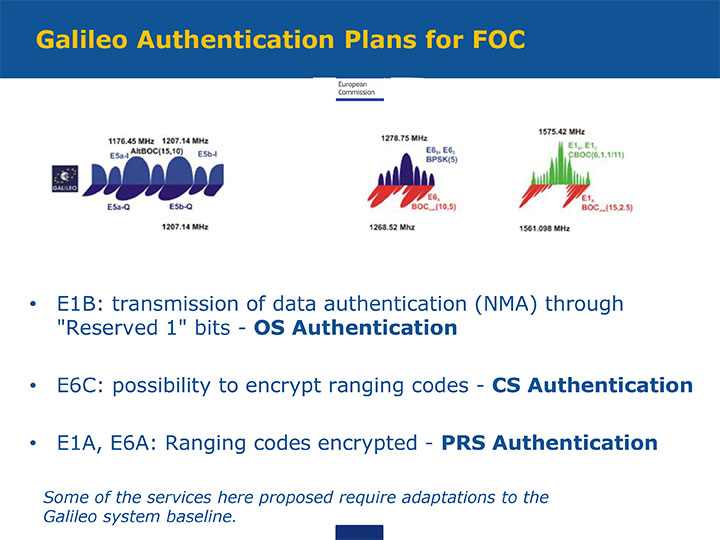
GNSS Resilience. The second plenary, on resilience, brought forth some of the most pointed commentary of the conference. Ignacio Fernández Hernández of the European Commission spoke on Galileo differentiators for resilience: its authentication plans for the Open Service, Commercial Service, and Public Regulated Service, respectively. “The proposed GNSS authentication services are 100 percent backward compatible and interoperable with other receiver-based technologies.”
Slide from presentation by Ignacio Fernández Hernández of the European Commission on Galileo differentiators for resilience. (Courtesy of the EC)
Hernandez proferred the caveat that “some of the required changes to deliver these services (particularly OS authentication) are pending on an impact analysis by industry/ESA and are not yet in the baseline. We hope however to have them in the baseline soon and we’re working hard for it.”
Matteo Paonni of the EC’s Joint Research Centre addressed spectrum management and regulatory issues, specifically the hot-button topic pseudolites. The EC is working closely with the United States and others to limit potential in-band interference risks. Outdoors, pseudolites are clearly undesirable; indoors, they offer some potential, but must be controlled.
Paonni stressed that there is a clear need to protect GNSS spectrum, and that the EC and its member states are doing their utmost to install such protections, and are also promoting GNSS radio-frequency interference detection and mitigation initiatives. Galileo’s PRS is more robust and resilient, but it is not invulnerable. GNSS vulnerabilities should be appreciated and backups put in place for critical systems; backups such as eLORAN, mini atomic clocks, GSM network, and so on.
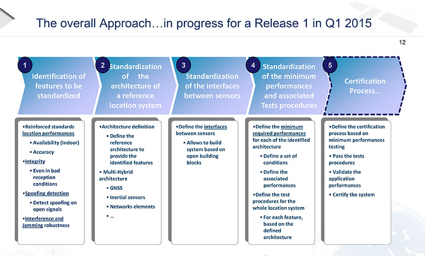
Michel Monnerat of Thales Alenia Space focused on resilience in the road and LBS sectors. With a wide range of environments, devices and applications coming into play, “we need standardization” to specify levels of integrity and levels of performance for each different set of parameters. Thales Alenia is developing just such a set of performance requirements and references, with a first version set for release and discussion soon.
Slide presented by Michel Monnerat of Thales Alenia Space, which is working on a standardization protocol proposal, to be released soon. (Courtesy of Thales Alenia Space)
The magazine has not carried much GLONASS news in recent months, yet we continue to cover Galileo with some assiduousness and we devoted several pages to Beidou in December. In all three cases, we find an absence of real news in the sense of verifiable happenings, satellite launches, new applications by users, or releases of products you can wrap your hands around.
No, in all three systems we have pronouncements, prognostications, and promises of satellites future. Ongoing deliberations, budget wrangling, internal disputes, delays, cost overruns, turf squabbles, and discussions postponed until the next round of meetings. Hmmm. These young upstarts sound remarkably akin to their older cousin, GPS.
Aha — but! GPS launched a satellite in November, and declared it operational for users on December 13. Not only a new satellite, a new kind of satellite, with new codes. That may not be news on the order of "man bites dog," but it is undeniably authentic, progressive, practical, and actually useful news you can use.
Why cover Galileo and Beidou, while devoting scant attention to GLONASS?
Well, Beidou is new, only very recently and suddenly being talked about as a truly global NSS. It is all talk at this point, but it’s fascinating talk, and comes from a region that has long held itself mysterious, aloof. Hard information is extremely difficult to come by. We’re reduced to scrutinizing the inscrutable, reading the tea leaves of government releases and newspaper stories within China, where the government controls the press. Even the analysts whom we canvass haven’t much better sources. So, play hard to get, you Beidou designers . . .
Galileo is completely another story. Or six or seven other stories. A soap opera, it keeps unfolding, plot-twisting, introducing new characters and controversies, and leaving you cliffhanging from one episode to the next. Politics play a very overt role, as 151 constituencies try to resolve issues to everyone’s satisfaction. While continuing — here’s the real trick — to move forward. That keeps us tuning in.
Meanwhile, Russia bravely carries on its own tradition, promising three new, longer-lived satellites by Christmas and 18 or 24 by 2008, an upgraded service freely available anywhere in the country and soon (or later) the world, a new Five-Year Plan better than the old Five-Year Plan, which went unattained. Not through lack of trying, but through lack of money, and a crumbling infrastructure. This may be lamentable and the new optimism estimable, but is it news? Can I use it?
The Kremlin has no lock on inflated goals and blue-sky promises. This desk receives plenty of that from industry. Yes! In this country! And others. Our intent is to filter that out, to deliver only that which may truly affect our readers.
News doesn’t exist in a vacuum. It requires people, and a demonstrable effect on those people, to become news.


 It’s funny sometimes how things work out. I had just been preparing to take up in this column an issue raised last September at the ION-GNSS+ Plenary Session. Literally at the very moment I set pen to paper, notice of an extremely positive response to the problem arrived in my inbox. Hypercoincidental as it may be, market forces can and do work in mysterious ways, inexorably driving forward progress.