Tag: outdoor recreation

  • Garmin unveils Xero L60i laser rangefinder with GPS and onboard mapping

    Garmin unveils Xero L60i laser rangefinder with GPS and onboard mapping

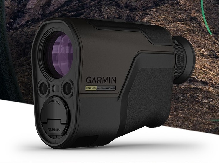
    Garmin has released the Xero L60i, a GNSS-enabled rangefinding monocular. The rangefinder’s optics providea sharp, bright view through augmented reality technology that overlays graphics in full color, including distance, maps and navigation and more — all while ranging targets out to 3600 meters through 7X magnification.

    Integrated navigation features include Laser Locate, Sensor Locate and Visual Recall, giving wildlife enthusiasts, researchers, search-and-rescue teams tools they can depend on, the company said.

    Xero L60i features

    • Digital mapping. View current and ranged locations marked on topographic mapping and use the Xero L60i to navigate to them.
    • Smart Integration. Waypoints can be shared to the Garmin Explore App on a compatible smartphone, then shared to a compatible Garmin handheld or wearable device using the Garmin Share functionality.
    • Laser Locate. Leverage the range taken, along with compass heading and GPS coordinates, to project a waypoint on the display, then navigate to the waypoint through directional cues.
    • Sensor Locate. When the desired object is too far to range, built-in GPS, compass, inclinometer and mapping can calculate and project a waypoint of the intended target, allowing estimated ranges to targets several miles away.
    • Visual Recall. When moving to a new vantage point after ranging, on-screen cues steer the visual field back to a previously marked waypoint.

    The rangefinder features fully multicoated, low-dispersion glass, which provides sharp optics with a flat field of view, accurate color fidelity, and superior light transmission. During dawn or dusk use, an ambient light sensor automatically controls display brightness, ensuring the visual scene remains clear.

    Range animals to 2,775 meters and trees to 3,600. In optimal low-light conditions, the Xero L60i makes it possible to reach as far as 7,000 meters to retro reflective objects while achieving accuracy of +/- .25 meters under 1,000 meters and +/- 1 meter out to maximum laser-ranged distances.

  • Garmin adds L5 to new adventure trackers

    Garmin adds L5 to new adventure trackers

    Photo: Garmin
    Photo: Garmin

    Garmin has debuted the GPSMAP 65, 65s and 66sr, three new portable devices with improved technology, precision and connectivity. GPSMAP is the company’s line of premium outdoor navigation units.

    The GPSMAP 65, 65s and 66sr offer multiband technology for positioning and tracking anywhere. They are the first Garmin portable devices to receive and use multiple satellite navigation frequencies.

    The multi-band technology and expanded GNSS support with addition of the L5 frequency (GPS, GLONASS, Galileo, QZSS and IRNSS) allows for reduced estimated position error, giving users improved accuracy and awareness of their surroundings.

    The new models include TopoActive maps of Europe, smartphone notifications, color screens, battery improvement, compatibility with the Garmin Explore app and more. All three are rugged, dust, shock and water resistant (IPX71 rated).

    “We are excited to grow our popular lineup of GPSMAP handhelds and introduce multiple GPS frequencies into the series,” said Dan Bartel, Garmin vice president of global consumer sales. “We’ve expanded our satellite support so you can explore with confidence, no matter where you go or what the conditions are.”

    GPSMAP 66sr

    The premium version, GPSMAP 66sr, has a 3-inch color screen readable in all lighting conditions and is compatible with night-vision goggles. In addition, it has been designed to military standards for thermal performance and resistance to shock and water (MIL-STD-810G), and includes a built-in S.O.S. LED flashlight for assistance. To give the user even more confidence, incorporates ABC sensors (3-axis electronic compass), accelerometer and barometric altimeter), allowing users to obtain the most accurate data available at all times.

    GPSMAP 66sr also provides global forecasts and weather through the Active Weather feature, updated through wireless connectivity via Bluetooth and ANT +. Via the Wi-Fi connection, users can download satellite maps.

  • Garmin’s latest watch features GPS, GLONASS and Galileo

    Garmin’s latest watch features GPS, GLONASS and Galileo

    Garmin is now offering a GPS, GLONASS and Galileo watch called Instinct. Instinct is a strong and durable watch with GNSS support, plus built-in 3-axis compass, barometric altimeter and wrist-based heart rate sensor.

    The watch includes a built-in sports apps, smart connectivity and wellness data.

    Photo: Garmin
    Photo: Garmin

    “We are thrilled to add Instinct to our adventure watch lineup, an approachable smartwatch that is rugged and reliable,” said Dan Bartel, Garmin vice president of global consumer sales. “Instinct is perfect for those who spend their time outdoors and demand a device built tough to stand up in the elements.”

    The Instinct is built to endure challenging environments, constructed to military standards (MIL-STD-810G) for thermal, shock and water resistance (rated to 100 meters) with a fiber reinforced polymer case. The chemically strengthened and scratch-resistant display is readable in direct sunlight, and the fully vented silicone bands include two independent, removable keeper loops to ensure a secure fit.

    The multi-GNSS feature helps users track their location in challenging environments. The Garmin Explore app helps plan the trip in advance, and the TracBack feature can navigate the same route back to the starting point.

    The built-in heart-rate sensor helps monitor heart rate, steps taken, distance traveled, calories burned and more.


  • New Garmin GPS handheld logs raw measurements in RINEX

    New Garmin GPS handheld logs raw measurements in RINEX

    Photo: Garmin
    Photo: Garmin

    Garmin International is offering a new outdoor GPS handheld that can log raw measurements in RINEX form, the GPSMAP 66

    “We’ve had good success achieving carrier-phase ambiguity resolution with the unit, and I suspect many readers will be interested in this feature from a purpose-built device,” said Jared Bancroft, GNSS sensors & algorithms, Garmin, in an email to GPS World. “We’ve observed accuracies down better than 30 centimeters.”

    The GPSMAP 66 is a premium outdoor handheld with expanded wireless connectivity, direct-to-device access to BirdsEye satellite imagery and a 3-inch sunlight-readable color display. The handheld comes in two models, the GPSMAP 66s and GPSMAP 66st. The latter offers preloaded topographic maps for U.S. and Canada.

    Professionals and serious GPS enthusiasts will appreciate the inclusion of RINEX data logging, which allows for sub-meter accuracy of GPS position after post processing, Garmin stated in a press release.

    “The GPSMAP 66st builds on the GPSMAP series heritage by adding new and requested features like a bigger screen, weather forecasting and easy direct-to-device access to satellite imagery,” said Dan Bartel, Garmin vice president of global consumer sales. “Between multi-GNSS network support and connectivity to the new Garmin Explore app, the new GPSMAP 66s and the GPSMAP 66st are reliable companions for any adventure.”

    The handheld can receive weather updates for real-time forecast information by being paired via Bluetooth to a compatible mobile device. It will also provide predictive maps for temperature and wind speed/direction, as well as live weather radar.


    Other new GPSMAP 66s/st connected features include Geocaching Live and compatibility to the Connect IQ platform, giving users access to 9 million trails through the preloaded Wikiloc app. The devices all pair with the inReach Mini, allowing the user to send and receive messages directly on their 66s/st device via the Mini.

    Between the multi-GNSS satellite support and  altimeter, barometer and compass sensor capabilities, the GPSMAP 66s/st will track an entire journey. The handheld devices have 16 hours of battery life in full GPS mode and can track the user’s position for up to one week using Expedition mode on a single set of AA batteries, the company said.

    The devices include an LED flashlight and SOS beacon that can be used to signal for help. It is built to military standards for thermal, shock and water performance (MIL-STD-810G).

  • Accident locator launched

    Saphibeat Technologies’ new Adventure Monitor PhiPAL can save lives of outdoor enthusiasts by recognizing when an accident has taken place.

    PhiPAL uses a proprietary machine-learning algorithm for accident recognition. If the user is unconscious, PhiPAL automatically sends a distress message with GPS coordinates to teammates and first responders through a cellphone or satellite connection.

    PhiPAL uses an activity monitor mounted on or integrated into the user’s sports helmet.

  • Garmin to acquire outdoor tracking company DeLorme

    
The DeLorme inReach Explorer.
    The DeLorme inReach Explorer.

    Garmin Ltd. has entered into an agreement to acquire substantially all of the assets of DeLorme, a privately held company that designs and markets consumer-based satellite tracking devices with two-way communication and navigational capabilities.

    The completion of the acquisition, which is subject to customary conditions, is expected to occur within 30 to 60 days.

    One of the most compelling products in the DeLorme portfolio is its inReach series of two-way satellite communication devices. These GPS-enabled devices allow the user to send and receive satellite text messages or trigger an SOS for emergency help, anywhere in the world. In addition to inReach, DeLorme has an extensive library of digital cartography and enterprise GIS software, as well as traditional mapping.

    “DeLorme is a respected brand with exciting products and technologies that are a natural fit in the Garmin portfolio,” said Cliff Pemble, Garmin’s president and CEO. “We look forward to completing the acquisition and welcoming them onto our team. We are looking forward to leveraging their expertise to further enhance the Garmin lineup of products.”

    Source: GPS world staff
    The DeLorme inReach Explorer is a two-way satellite communicator with built-in navigation.

    “Our inReach technology is invaluable to hikers, hunters, boaters and pilots who often find themselves in remote areas — Garmin’s core customers. We are looking forward to completing the acquisition and are excited to help leverage our expertise into enhancing their already outstanding products,” said Michael Heffron, CEO of DeLorme. “Garmin has extensive R&D capabilities and a global distribution network that will allow us to provide this technology to customers across many markets and around the world.”

    Garmin will retain most of the associates of DeLorme and will continue operations at its existing location in Yarmouth, Maine, following the completion of the acquisition. The Yarmouth facility will operate primarily as a research and development facility and will continue to develop two-way satellite communication devices and technologies. Financial terms of the purchase agreement and acquisition will not be released.

    For decades, Garmin has pioneered new GPS navigation and wireless devices and applications that are designed for people who live an active lifestyle. Garmin serves five primary business units, including automotive, aviation, fitness, marine and outdoor recreation.

  • Garmin Adds eTrex with Touchscreen to Outdoor Line

    Garmin Adds eTrex with Touchscreen to Outdoor Line

    The Garmin eTrex
    The Garmin eTrex can be mounted on bicycles, boats, ATVs or in the car.

    Garmin International this summer is releasing the eTrex Touch 25, 35 and 35t, adding new touchscreen models to its line of outdoor handhelds.

    The eTrex Touch series has a completely updated user interface, improving the ease-of-use of the device, as well as a 2.6-inch capacitive touchscreen display, the largest display that’s ever been put on an eTrex device. The eTrex Touch series also features new activity profiles for easy-to-use navigation for multiple activities and an enhanced track manager to easily start and stop recording.

    The new eTrex Touch series has a high-sensitivity, WAAS-enabled GPS receiver with GLONASS support and HotFix satellite prediction to locate users’ position quickly and precisely, even in heavy cover and deep canyons.All units in the eTrex Touch series have a built-in 3-axis tilt-compensated electronic compass, which gives directional information even when standing still. The eTrex 35 and 35t also have a barometric altimeter to get more accurate altitude, elevation and climb information, as well as indications of pending weather changes.

    The eTrex Touch 25, 35 and 35t are compatible with an array of mounts that are easy to use on bicycles, boats, ATVs or in the car, and offer a long-lasting 16-hour battery life, and a rugged ergonomic design to withstand the elements.

    The eTrex Touch series integrates a variety of new activity profiles. The device remembers how each profile is set up to each activity, and will set it up for users the same way every time, making it comfortable, quick and intuitive to use the same device for entirely different purposes. No matter if users are out rock climbing, hiking, hunting, cycling, geocaching or fishing, with an eTrex Touch, switching between activities is easier than ever, even if they’re done all in one afternoon.

    The eTrex Touch series comes preloaded with a worldwide shaded relief basemap, 4 GB of internal memory on the 25 and 35 models and 8 GB of internal memory on the 35t. The eTrex 35t also comes preloaded with TOPO U.S. 100K. With the built-in microSD card slot, users can install even more maps, like HuntView to see public and private land data while hunting, BirdsEye Satellite Imagery or TOPO U.S. 24K. All models come preloaded with 250,000 geocaches from Geocaching.com, so right out of the box users can start their geocaching adventure virtually anywhere in the world.

    The eTrex 35 and 35t incorporate wireless ANT+ connectivity to accessory sensors like heart rate monitors, the Tempe temperature sensor, Chirp geocaching beacon, or the cycling speed sensors and cadence sensors. The eTrex 35 and 35t can also act as a wireless remote control for the VIRB line of action cameras. The eTrex 35 and 35t can connect via Bluetooth to compatible smartphones to receive smart notifications and stay connected out on the trail, but keep their phone safely packed away from the elements. Additionally, these units are compatible with the the Garmin Connect mobile app, for features such as LiveTrack. With LiveTrack, users can pair their device with the app, and invite friends and family to follow their activity in real time. This provides peace of mind, especially if users are alone.

    The eTrex Touch 25 will have a suggested retail price of $249.99, the eTrex Touch 35 will have a suggested retail price of $299.99 and the eTrex Touch 35t will have a suggested retail price of $349.99.