NextNav has launched the first European commercial testbed for its high accuracy Pinnacle vertical location technology. Operating in Paris, France, the testbed will demonstrate the benefits Pinnacle can bring to local emergency response agencies and integration with applications and devices from existing NextNav partners.
Available across the United States in more than 4,400 cities and towns, and currently being deployed across Japan, Pinnacle technology provides z-axis data and has been demonstrated in independent testing to deliver 94% accuracy.
The announcement of a testbed in France comes after the release of a recent European Joint Research Centre (JRC) report, which highlighted NextNav’s accuracy in providing floor-level vertical location in addition to its ability to provide a resilient layer for traditional GPS services.
With a terrestrial-based system, NextNav aims to provide highly accurate 3D position, navigation, and timing (PNT) information — revolutionizing emergency services, logistics, telecommunications, and other sectors that rely on precise PNT and are otherwise vulnerable to GPS interference – an increasing concern across the region.
“Seen & Heard” is a monthly feature of GPS World magazine, traveling the world to capture interesting and unusual news stories involving the GNSS/PNT industry.
Photo: lindsay_imagery/E+/Getty Images
Where Sea Turtles Nest
Florida’s Sea Turtle Grants Program — funded with proceeds from special license-plate sales — were used to purchase Trimble TDC100 and TDC600 handheld GNSS receivers for state park staff to gather data about turtle nesting activity. The staff also uses Esri’s ArcGIS Survey123 field-capture software to report on turtles using the 108 miles of beach in 40 of Florida’s state parks. Negative impacts from commercial fishing, plastic waste and climate change have become a threat to sea turtles, which are now classified as an endangered species.
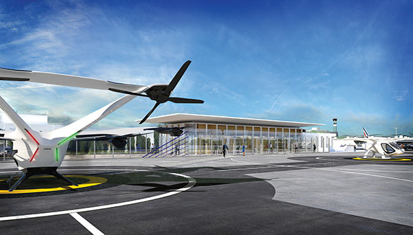
Concept of vertiport at airport. (Groupe ADP)
Paris up in the Air
Paris has begun testing electric air taxis at a new site outside the French capital, with an eye toward creating at least two demonstration flight paths during the 2024 Olympics to ferry passengers from nearby airports. Inaugurated in November, the test site is dedicated to new sustainable urban air mobility, and will study the use of electric vertical take-off and landing (eVTOL) aircraft. Choose Paris Region, Groupe ADP and RATP Group are managing the effort with VoloCity taxis by Volocopter onboard.
Photo: Stanislav Ostranitsa/iStock/Getty Images Plus/Getty Images
Russia Threatens GPS
The Kremlin warned it could blow up 32 GPS satellites with its new anti-satellite technology (ASAT), which it tested Nov. 15 on a retired Soviet Tselina-D satellite, according to numerous news reports. Russia then claimed on state television that its new ASAT missiles could obliterate NATO satellites and “blind all their missiles, planes and ships, not to mention the ground forces,” said Russian Channel One TV host Dmitry Kiselyov, rendering the West’s GPS-guided missiles useless. “It means that if NATO crosses our red line, it risks losing all 32 of its GPS satellites at once.”
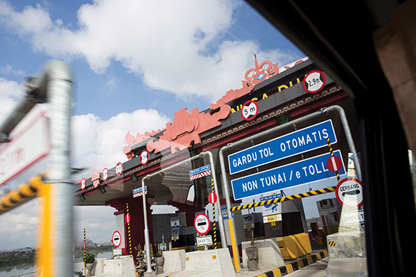
Bali toll gate. (Photo: dwart/iStock/Getty Images Plus/Getty Images)
Indonesia Goes Cashless
Indonesia’s GNSS-based cashless toll system will take effect by the end of 2022, reports Indonesia Expat. The country’s Public Works and Public Housing Ministry plans to have its multi-lane, free-flow-based non-cash toll transaction system implemented on 40 toll roads on the islands of Java and Bali. MLFF uses GNSS plus a map-matching process and special toll road apps on smartphones to determine fees. The system is expected to increase efficiency, effectiveness, security and convenience in conducting toll road payment transactions.
Your phone or satnav receiver routinely picks up signals from navigation satellites in order to tell you precisely where you are. But have you ever thought what happens to those satnav signals afterwards? A foresighted ESA inventor had the idea of using them as a tool for observing the Earth.
More than 120 satellite navigation satellites are in orbit, making up multiple constellations including Europe’s Galileo system, sending down a continuous rain of satnav signals for the benefit of users worldwide. Just like visible light, these microwave signals go on to reflect off Earth’s land and sea surfaces.
The traditional attitude to these reflected signals is to see them as something of a nuisance — known as multipath, they can confuse satnav receivers and reduce their overall accuracy.
ESA microwave engineer Manuel Martín-Neira, inventor of the PARIS reflectometry concept. (Photo: ESA)
But back in 1993 — at the same time as the US GPS satnav system reached its full constellation of 24 satellites — a young ESA microwave engineer called Manuel Martín-Neira came up with the idea of treating these satnav reflections as a scientific resource instead.
“My head of division asked me to come up with a budget-friendly way of increasing the overall sampling rate to build up a fuller picture of mesoscale phenomena, and that led me to start looking into making use of additional signals of opportunity, chiefly satnav signals.
“The initial reaction was mixed, because the forecast accuracy was not as precise as the ERS-1 altimeter could deliver — but on the plus side there would be a lot of these signals to make use of, and the performance has improved a lot since those early days.”
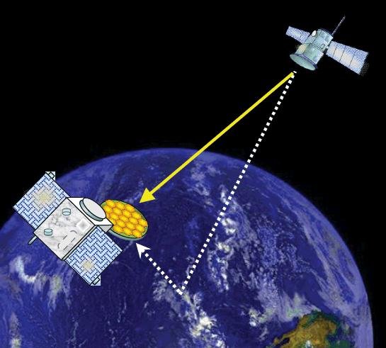
PARIS, detecting reflected satnav. (Photo: ESA)
Inspiration from reflection
The basic idea of what Manuel christened the Passive Reflectometry and Interferometry System, or PARIS, comes down to a two-sided antenna. As the topmost side picks up a satnav signal from the satellites in orbit, the other side picks up the version of the signal bounced back from Earth.
By comparing this initial, overhead signal with its reflected equivalent using a process called interferometry — measuring tiny differences in signal phases – the extra travel time of this reflected beam can be determined, down to an accuracy of less than five centimetres, determining sea height and sea ice thickness.
Additional amplitude waveform processing can deliver further data on wind and wave measurements over the ocean, and soil moisture and biomass over land.
Satellite reflectometry has since grown into a thriving field. This summer, Manuel attended the latest international workshop on the method he first devised 26 years ago.
Reflectometry reaches space
“It’s been fantastic to have experimental evidence, and that’s really been made possible by the growing availability of smaller satellites,” explains Manuel.
“Because satellite reflectometry is a passive form of remote sensing, it makes for an attractive potential payload because it doesn’t need a lot of power to operate. Then one of the results is meteorology data that private companies intend to make money with by delivering to public agencies.”
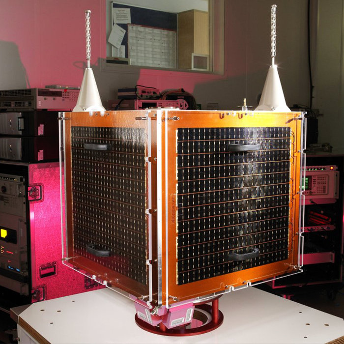
Surrey Satellite Technology Ltd.’s UK-DMC satellite was the first orbital mission with a reflectometry payload. (Photo: ESA)
In 2003, the UK-DMC satellite was the first mission to fly a reflectometry payload, followed in recent years by, for example, the UK’s TechDemoSat-1, NASA’s CyGNSS constellation to monitor hurricanes and the Spire global constellation of commercial nanosatellites.
“These satellites have really given the reflectometry community a wealth of signals, demonstrating what reflections look like over different surfaces including sea ice, forests, and even inland water bodies such as the Amazon River and its tributaries.
“In parts of the ocean near continental masses and within atolls we are seeing reflected signals from very calm waters which resembled a mirror, giving us very high precision down to 1 cm level. Such measurements could potentially complement current altimetry missions, by for instance measuring sea level rise.”
Example of a CYGNSS Microsatellite Observatory. (Image: Southwest Research Institute)
ESA activities taking flight
ESA meanwhile is active on reflectometry in various ways, having developed and tested a steerable airborne antenna called the Software PARIS Interferometric Receiver or SPIR, capable of steering separate antenna beams to build up a rapid surface picture, and differentiating between different signal sources, such as GPS from Galileo.
Manuel adds: “ESA’s GNSS Science Support Centre, based at the Agency’s European Space Astronomy Centre near Madrid, has been taking a keen interest in these activities.”
Missions are also in development, including a dedicated CubeSat with RUAG-Austria and the University of Graz called PRETTY (for Passive REflecTomeTry and dosimetry, which would also carry a radiation detector), and a small satellite pair called FSSCat from Spain’s Universitat Politècnica de Catalunya, backed through the Copernicus Masters competition, seen as a prototype for a future reflectometry constellation.
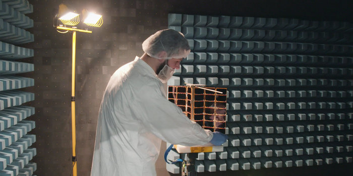
ESA’s Directorate of Telecommunications and Integrated Applications is also working with the Spire company to fly enhanced reflectometry instruments, starting at the end of this year.
One of Spire’s Satellite Manufacturing Technicians (Tomasz Chanusiak) tests the Radio Frequency capabilities of a LEMUR2 nanosatellite in Spire’s cleanroom in Glasgow, Scotland. (Photo: ESA)
When it comes to the thriving state of today’s reflectometry community, Manuel recalls the patenting of his idea as a turning point: ‘Having had this idea, which was not particularly well received, the proposal by ESA’s Patents Group to patent it made all the difference. It gave me a feeling of confidence, that somebody else at least saw the potential of this idea — and the rest is history.”
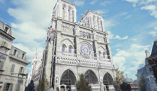
Detailed 3D maps of the iconic and historic Notre Dame Cathedral in Paris hold out hope for accurate reconstruction after it was devastated by a massive fire April 15. Both the ceiling and the spire were destroyed, as well as internal woodwork.
But the information to restore the cathedral is abundant. Besides photos, in 2015 art historian Andrew Tallon used laser scanners to create an immaculately accurate model of the cathedral, as reported in this National Geographic feature.
Laser scans, with their exquisite precision, don’t miss a thing. Mounted on a tripod, the laser beam sweeps around the choir of a cathedral, for example, and measures the distance between the scanner and every point it hits. Each measurement is represented by a colored dot, which cumulatively create a three-dimensional image of the cathedral. “If you’ve done your job properly,” says Tallon, the scan is “accurate to within five millimeters [.5 centimeter].”…
Tallon figured out how to knit the laser scans together to make them manageable and beautiful. Each time he makes a scan, he also takes a spherical panoramic photograph from the same spot that captures the same three-dimensional space. He maps that photograph onto the laser-generated dots of the scan; each dot becomes the color of the pixel in that location in the photograph.
As a result, the stunningly realistic panoramic photographs are amazingly accurate. At Notre Dame, he took scans from more than 50 locations in and around the cathedral—collecting more than one billion points of data.
Assassin’s Creed Unity. Another source comes from a video game company. Immaculate models of the cathedral were collected for the creation of the best-selling “Assassin’s Creed: Unity,” where the hero/player is able to climb both the outside and inside of the massive edifice.
An artist for the Ubisoft game, Caroline Miousse, told The Verge:
In the case of the Notre Dame, easily the biggest structure in the game, it meant recreating a version of the cathedral that didn’t actually exist at the time. Level artist Miousse spent literally years fussing over the details of the building. She pored over photos to get the architecture just right, and worked with texture artists to make sure that each brick was as it should be.
The afternoon festival included races and demonstrations of the unmanned aerial vehicles (UAVs). In a cage topped by a 100-meter-long net, drones competed in races, going as fast as 100 kilometers per hour as drone operators guided their UAVs through a brightly colored obstacle course.
The festival had an educational goal, reports phys.org, with displays on the regulations, the drone’s various uses, and workshops on piloting them.
The festival also was an occasion for the postal service to demonstrate its delivery drone, which weighs 3.7 kilos (eight pounds) and can carry three kilos of mail over 20 kilometers (12 miles).
Behind the security gates, 150,000 attended, and 30,000 watched the live stream.
The next time I see Paris, I will be swinging down the boulevard in a brand new set of threads. An elegant, location-enabled set of threads that will take me by the sleeve and lead me through the City of Light.
This wearable experiment goes by the name — of course it does — Navigate, a new line of city-specific, location-enhanced apparel. Either plug or Bluetooth the jacket (the press materials are not clear on this point) into your smartphone, download the appropriate city guide with walking tour, and start your adventure. Stash the phone in the pocket of the houndstooth jacket with red felt collar flips, no further need to look at it. Vibrations along left or right arm tell you when to turn; their frequency, intensity, and placement vary to indicate soft turn, merge, or hard turn.
Oh, I love the colorful clothes she wears, and the way the sunlight plays upon her hair . . . I’m pickin’ up good vibrations, oom bop bop, she’s giving me excitations, oom bop bop.
Good, good, good, good vibrations.
“How we can ease the stress of navigating an unfamiliar path without interfering with the experience of discovering a new place?” asks Billie Whitehouse, design director of Wearable Experiments. “No longer do you need to hunch over a map or smartphone. Now you can experience fill-the-blank-here as a traveler rather than a tourist.”
Not interfering with the experience of discovering a new place: that caught my attention. In my misspent youth, I traversed the upper Amazon, the Andean highlands, and the Galapagos Islands unencumbered by a camera. To my lasting regret. I thought the device lifted to my eyes would interfere with my discovery and experience. Now I see my error. Instead of subtracting a layer of technology from my travel trunk, I should have added one. That GPS did not exist at that time, except as a gleam in young Col. Parkinson’s eye, perhaps absolves the fault in this case.
“The skin is a vastly underutilized form of communication,” says Wear:Ex technical director Ben Moir. “Haptic vibrations are built into a full physical language, allowing the technology to communicate critical information. Technology doesn’t need to be invasive or obtrusive. It should be designed with the human at the center.”
From signals in space to the surface of my skin. It doesn’t get much more human-centric than that.