AgEagle will acquire senseFly, a Parrot Group subsidiary, for US$23 million.
AgEagle Aerial Systems Inc. is a a provider of drones, sensors and software, and Parrot is a European drone company. Founded in 2009, senseFly develops and produces a proprietary line of eBee-branded, high performance, fixed wing drones for professional use.
The eBee Geo drone was introduced in March. (Photo: SenseFly)
The development positions AgEagle to provide a full-stack fixed-wing drone solution for agriculture, government, engineering and construction, among other industry verticals. SenseFly also brings to AgEagle solid engineering talent focused on advanced research and development, a well-established global reseller network, and a strong portfolio of intellectual property, AgEagle stated in a press release.
The eBee drones are designed to be safe, ultra-light and easy to use. They are in use by thousands of customers around the world in agriculture, government, engineering and construction to collect aerial data. Headquartered in Lausanne, Switzerland, senseFly employs 90 people, generating total annual revenues of US$12.5 million in 2020.
“Recognized as the producer of the world’s most widely used fixed wing drones, senseFly is an ideal strategic fit for AgEagle,” said Brandon Torres Declet, chief executive officer of AgEagle.
Moving forward, Parrot will focus its expertise and resources on the growth of its professional quadcopter drone equipment and drone data analysis software activities, according to Parrot founder and CEO Henri Seydoux. “The transaction will provide additional cash and lower operational expends to drive Parrot’s growth and industry standing,” Seydoux said. “With the capabilities of the ANAFI line of professional drones and of the Pix4D software suites, Parrot will continue to address its core market segments: 3D mapping, surveying and inspection, agriculture, and defense and security.”
In tandem with the closing of the acquisition, which is expected shortly, Labossiere will resign as CEO of senseFly. Michael O’Sullivan, who previously served as the company’s head of global marketing, will be appointed managing director of the new AgEagle subsidiary. All other senseFly employees will retain their current responsibilities.
For details relating to the terms and conditions of the acquisition, refer to the Form 8-K to be filed by AgEagle with the U.S. Securities and Exchange Commission upon closing of the transaction and accessible at www.sec.gov.
A roundup of recent products in the GNSS and inertial positioning industry from the August 2021 issue of GPS World magazine.
OEM
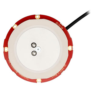
GNSS board
Photo: Javad GNSS
With GLONASS dynamic calibration
The TRE-3S GNSS board measures 100 x 80 mm, weighs 87 g and tracks 874 channels with all-in-view satellite tracking. It includes numerous features to protect against interference and improve signal output: spectrum data output, spoofing detection, advanced multipath reduction, in-band interference rejection, GLONASS 0.2-mm dynamic calibration, heading determination, attitude determination and fast acquisition channels. The TRE-3S receives GPS L1/L2/L2C/L5; Galileo E1/E5A/E5B/AltBoc/E6; GLONASS L1/L2/L3; BeiDou B1/B1C/B2/B3; QZSS L1/L2/L5/L6 (L61/L62); and SBAS L1/L5. It has a 20-Hz update and real-time kinematic (RTK) rate for real-time positioning and raw data (code and carrier). Optional features include tracking QZSS L6 (LEX) and IRNSS L5/S-band, and a data update rate and RTK rate of 100 Hz.
For high-precision applications with L-band corrections
Photo: Maxtena
The M9HCT-A-SMA is a patented helix antenna for GNSS plus L-band corrections services, suitable for high-precision and autonomous multi-frequency applications. It provides simultaneous GNSS reception in a rugged, compact form factor. The M9HCT-A-SMA is suitable for high-precision applications such as the UAV market, where high performance and low weight are driving features in antenna selection. The active helix design features Maxtena’s patented compact and lightweight Helicore technology, which provides excellent pattern control, polarization purity and high efficiency in a compact form factor.
New eXtended Filtering (XF) is now employed in the TW3900 series of Accuntena precision antennas. The XF feature mitigates interference from all near-band signals and ensures the antenna provides the purest possible GNSS signals. The custom XF filtering has been tested to mitigate new (in Europe and Japan) and existing LTE signals, enabling the XF antennas to produce clean and pure GNSS radio frequency data. The XF models are TW3972XF, TW3972EXF, TW3972LGXF, TW3967XF and TW3967LGXF. All are triple-band antennas that support GPS/QZSS (L1/L2/L5), GLONASS (G1/G2/G3), Galileo (E1/E5ab), BeiDou (B1/B2/B2a), NavIC L5 and L-band correction services.
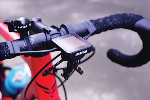
The iGS320 cycling computer builds on the u-blox M10 positioning platform, leveraging the M10’s ultra-low power consumption, compact size, and ability to track all four GNSS to offer endurance athletes a superior user experience. Adopting the M10 in its iGS320 cycling computer brought iGPSPORT an 80 percent increase in the power autonomy to deliver 72 hours of continuous tracking, up from 40 hours in their previous device. Concurrent reception of up to four GNSS constellations increases coverage and accuracy in otherwise challenging signal environments.
The Beamo 3D mapping platform enables surveyors to scan a project site and immediately collaborate with teams in the field without lengthy delays or cumbersome equipment. The digital twin created in the platform provides a single and secure source of truth for teams without requiring highly technical knowledge. With a 360-degree camera, surveyor teams can create detailed digital environments that remote teams can use to track progress, collaborate with coworkers, and take accurate measurements without having to physically visit the site.
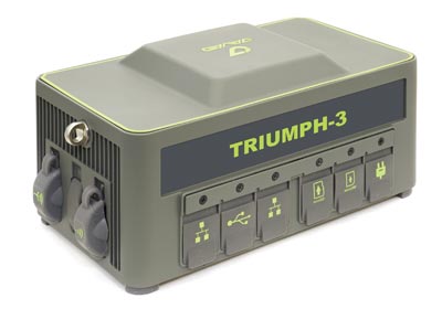
The Triumph-3 receiver tracks efficiently even in difficult conditions. It can track all current signals and is ready for future satellites. The Triumph-3 can operate as a base together with Triumph-LS and Triumph-LS Plus to efficiently accomplish any geodetic job. Its RTK system communicates via integrated UHF, 4G/LTE, Wi-Fi and Bluetooth channels, and eliminates the need to subscribe to a real-time network for corrections. A powerful and reliable receiver for high-precision navigation systems, the Triumph-3 is based on the Javad GNSS 874-channel chip. It is equipped with an internal 4G/LTE/3G card and secure and accessible microSD and microSIM cards. It also supports Javad’s lift-and-tilt technology.
Eos Bridge enables almost any instrument to become iOS Bluetooth compatible. The pocket-sized device connects to instruments via Bluetooth Classic or serial port, and then transmits data to any Apple iOS device, such as iPhone or iPad, Android device or Windows mobile device. Instruments equipped with non-iOS Bluetooth can connect to Apple iOS devices using the Eos Bridge, including laser rangefinders and utility-locating instruments. Instruments whose only connectivity option is a serial port also can connect, such as any instrument or sensor with an RS-232 serial port. The Eos Bridge is lightweight, at approximately 150 grams (about 5.3 ounces). It can be worn clipped to a belt, stored in a pocket, or mounted to an instrument or sensor. The battery lasts 48 to 72 hours.
The OceanReports web tool provides users with specialized “ocean neighborhood analyses,” including maps and graphics, by analyzing more than 100 ocean datasets instantaneously. Reporting data includes information about habitats and species, industries in the area, potential hazards (such as undersea cables or shipwrecks), the economic value of ocean commerce, and other detailed oceanographic information. The web-based interactive tool for ocean mapping and planning, created by the National Oceanic and Atmospheric Administration (NOAA) and the Department of the Interior’s Bureau of Ocean Energy Management, provides professional users and the general public with opportunities to explore the ocean from their own computer.
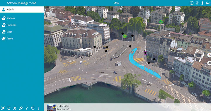
HxGN Mass Transit is a geospatial transportation infrastructure management system with 3D and AI capabilities for visualizing and analyzing transit and rail assets and operations. Built on Hexagon’s M.App Enterprise, HxGN Mass Transit provides an advanced digital twin of a city’s entire public transportation network — including tracks, stops, switches, construction sites, ticket machines, benches and garbage cans. It integrates asset and spatial data so operators can visualize and analyze an entire network with accurate and up-to-date information.
The GAJT-410MS provides anti-jamming to marine vessels. (Image: NovAtel)
The GAJT-410MS provides NovAtel’s GPS Anti-Jam Technology (GAJT) for the commercial and defense marine markets. The low SWaP variant protects civil and military operations from interference and jamming, with jammer direction-finding capabilities for enhanced situational awareness in the marine environment. The GAJT-410MS provides dynamic protection on both GPS L1 and L2 bands, as well as Galileo E1, QZSS L1 and L2, and SBAS L1 to combat intentional and unintentional interference.
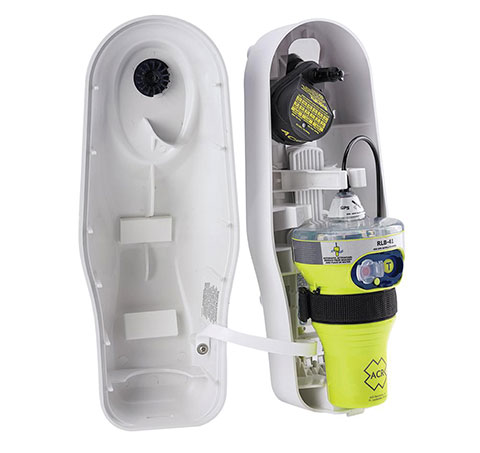
The ACR 2830 GlobalFix V4 EPIRB marine distress beacon has multiple built-in redundancies to increase chances of survival in an emergency situation. The internal GPS receiver pinpoints the user’s location, which is then transmitted on the 406-MHz distress signal. In the absence of GPS-derived coordinates, the signal can be used to triangulate the position. The beacon’s 121.5 MHz homing signal will bring local search-and-rescue forces directly to the position; an LED strobe light allows them to see the position in low light. A Category 1 Emergency Position Indicating Radio Beacon (EPIRB), the GlobalFix V4 is a float-free device that will automatically activate when submerged in water. Two self-tests monitor transmission, power and battery performance as well as GPS acquisition.
A new connected platform for rail passengers with Wi-Fi, information and entertainment content is being installed on OUIGO Spain trains through the OUIFUN portal. Passengers can connect via smartphones, tablets or PCs, access the internet on board to check email or browse the web, and enjoy entertainment content. Passengers also will be able to get travel status information in real time via an interactive map, access tourist guides or consult a menu for on-board catering. The service, provided by Moment, launched on May 10 on OUIGO’s first high-speed line in Spain connecting Madrid to Barcelona, and will gradually be extended to the whole high-speed OUIGO network.
The ANAFI Ai UAV uses 4G as its main data link between the drone and the operator. The 4G link improves data transmission and enables precise control at any distance. For BVLOS flights, it stays connected even behind obstacles. The 4G link between the drone and the user’s phone is encrypted, with a secure element protecting both software integrity and data privacy. A software development kit enables creation of custom code for flights and gives access to all sensors, including obstacle-avoidance sensors, occupancy grid and internet access.
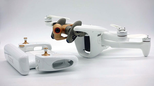
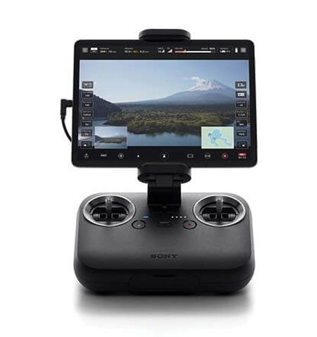
An introductory model in Sony’s new Airpeak line, the small S1 drone can be equipped with the company’s full-size mirrorless interchangeable-lens Alpha camera. Its proprietary motor, propeller, control system and sensing technology allow it to fly at high speed (a maximum speed of 55 mph) with stable wind resistance. Propulsion technology using a combination of devices developed by Sony provides wind resistance in strong wind speeds up to 44.7 mph. The Airpeak S1 includes obstacle detection, automatic flight control via sensing, and increased safety via cloud management of the aircraft.
At 80 grams, George is a low SWaP certifiable solution for enterprise operations and those wishing to type certify their UAS. Built around the open-source autopilot Cube from CubePilot, George combines Cube with Design Assurance Level C (DAL-C) hardware and safety and sensor monitoring, enabling customers to meet the type certification and safety case requirements for BVLOS operations. Its triple-redundant IMU includes three accelerometers, three gyroscopes, three magnetometers and three barometers. The hardware platform is designed and built to RTCA DO-254 DAL-C and meets rigorous DO-160G and MIL-810H power and environmental qualifications.
Drone-maker Parrot has released a new drone for professionals. The ANAFI Ai UAV uses 4G as its main data link between the drone and the operator, so that users will no longer experience transmission limitations.
The 4G also enables precise control at any distance. For beyond-visual-line-of-sight (BVLOS) flights, it stays connected even behind obstacles.
For the first time, ANAFI Ai embeds a secure element in the drone and in its Skycontroller 4. The 4G link between the drone and the user’s phone is encrypted. The secure element protects both the integrity of the software and the privacy of data transferred.
Parrot’s piloting application is open source. Parrot offers developers a software development kit (SDK) to create custom code for the drone to execute during flight. The SDK gives access to all flight sensors, including obstacle-avoidance sensors, occupancy grid and internet access.
ANAFI Ai’s obstacle-avoidance system detects obstacles in all directions, using stereo cameras to sense objects and automatically avoid them.
ANAFI Ai incorporates a 48MP main camera and a powerfully stabilized 4K 60-fps/HDR 10 camera to capture finely detailed aerial images and smooth video footage.
ANAFI Ai will be available in the second half of 2021 through Parrot Drone Enterprise Partners and Enterprise Drone Reseller Network.
A bill moving through the U.S. Congress would impose a five-year ban on United States government purchases of drones manufactured or assembled in China, reports The Associated Press. The measure reflects bipartisan concerns that the unmanned aerial vehicles (UAVs) made in China could facilitate Chinese spying on critical infrastructure.
Major commercial and consumer UAV-maker company DJI is based in Shenzhen, China. Many of its small, low-altitude drones are employed by local and regional government users in law enforcement, emergency response and surveying. The ban could affect police departments that rely on federal funds for equipment. In 2020, the Department of Homeland Security halted such grants for Chinese-made drones.
Chinese-made components, including GNSS receivers and inertial sensors, are not addressed in the bill, and the Pentagon has acknowledged that many components for non-Chinese-company drones are made in China.
While the ban wouldn’t go into effect until 2023, many federal agencies have already imposed temporary restrictions on the use of Chinese drones. The Interior Department had flown more than 11,000 drone missions before January, when the agency temporarily grounded its fleet of more than 500 DJI drones over cybersecurity concerns, according to The Hill. The Hill cites a May 6 Pentagon report. The report found no malicious code in the software for DJI’s Government Edition drones.
An analysis by Booz Allen Hamilton released in June 2020 found no evidence that DJI drones have shared sensitive information with the company or the Chinese Communist Party.
In August 2020, the Defense Department issued approval to drones from five companies:
Skydio’s X2-D. Skydio is based in Redwood City, California.
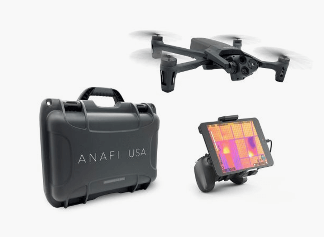
Parrot’s Anafi USA. While Parrot is based in Paris, France, the ANAFI USA drone is manufactured in the United States for U.S. customers.
Teledyne FLIR’s Flir M440 Ion. The drone was originally made by Altavian in Florida, which was acquired by FLIR in December 2020, which was subsequently acquired by Teledyne Technologies in January. Teledyne FLIR is headquartered in Wilsonville, Oregon.
Teal Drones’ Golden Eagle. Teal Drones is based in Salt Lake City, Utah.
Vantage Robotics’ Vesper. Vantage is based in San Leandro, California.
Drone company Parrot is partnering with Rapid Imaging, a technology provider delivering geospatial augmented reality (AR) and situational awareness solutions to government and enterprise users.
The partnership pairs Parrot ANAFI USA platform drones and the FreeFly SDK with Rapid Imaging’s SmartCam3D SDK, a geospatial augmented reality and situational awareness platform for unmanned aircraft systems.
SmartCam3D overlays geospatial data such as street vectors, road names, points of interest, polygons and other pertinent map entities onto real-time, full-motion video (FMV) provided by ANAFI USA’s 4K HDR video, 32x zoom and live video streaming capabilities. This provides mission personnel with advanced situational awareness as they perform critical drone operations.
SmartCam3D also allows end-users to interact with live drone video in the same ways they would a map display, such as dropping a pin to mark a location or geocoding a selection from the real-time video stream.
These situational awareness capabilities provide opportunities across a variety of mission sets: airborne law enforcement, insurance, industrial inspections, natural disaster response, real estate and search-and-rescue operations.
The SmartCam3D SDK is a turn-key solution for UAS platform providers seeking to enrich their offerings with geospatial augmented reality and situational awareness tools. Features include geospatial AR, allowing users to enjoy a “Google Maps” type experience but with live drone video as the background layer rather than a satellite image. Granular declutter options allow users to select the types of map entities displayed on their live video feed.
Custom GIS data integration allows users to import their own geospatial data to display. Pin-dropping allows users to mark locations within the live video with AR annotations and communicate those locations to a map display.
Also, forward- and reverse-geocoding allow professional drone pilots to designate a point in the video and immediately receive the geospatial data associated with that point (lat/long or address) or designate a location and mark the location with an AR annotation within the video display.
Finally, cross-Cuing allowing end-users to simultaneously navigate a full-motion-video display and map display.
“Leveraging Parrot ANAFI USA’s precise GPS coordinates and advanced flight features, SmartCam3D® provides first responders and military personnel with up-to-date geospatial AR overlays on live video, combining the benefits of both a 2D map display and a Full-Motion-Video display into a single operating picture.” said Jerome Bouvard, director of Strategic Partnerships, Parrot. “This new partnership will provide easy-to-comprehend data to better assist first responders into making quick and accurate decisions during high-stress missions.”
All data captured through SmartCam3D during sensitive missions is secure, as Parrot drone users must opt-in to share flight data with Parrot’s secure to store footage. Parrot ANAFI USA also features secure digital (SD) card encryption, which ensures complete protection of photos and videos if the drone or the SD card is lost.
The SmartCam3D SDK is available for Android, iOS, Linux, and Windows systems for use with ANAFI and ANAFI USA platform drones.
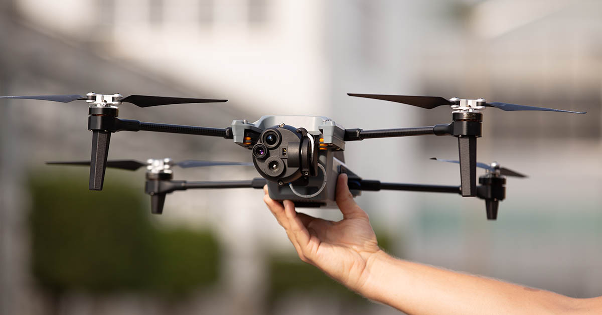
Parrot drones professional users benefit from an advanced control during complex fleet operations
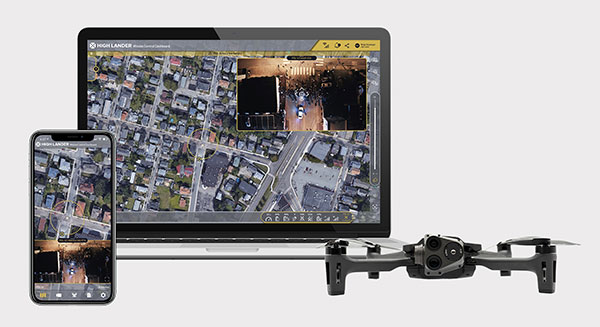
Drone company Parrot is partnering with High Lander, which provides drone fleets with autonomous flight, intelligent airspace control, and coordinated air continuity through its Mission Control platform.
Combining Parrot ANAFI USA and ANAFI platform drones with High Lander’s Mission Control software, professionals can now access drone features through an easy-to-use dashboard.
“Parrot is continuously striving to provide our professional users with extended capabilities — allowing them to rapidly adapt their drone operations to fit their changing and urgent needs,” said Jerome Bouvard, Parrot director of strategic partnerships. “Drone automation and intelligence are at the heart of our product and software developments. This new partnership with High Lander represents another step towards enhanced automation and control capability of our drones.”
Using real-time device reporting and telemetry, first responders can autonomously manage their drone fleets while performing takeoff and landing, route-planning, and other crucial tasks — all from the intuitive comfort of the Mission Control Operations Center dashboard. The software’s seamless interface paired with the ANAFI USA’s ease-of-operation and rapid deployment provide more safety for responders and allow faster intervention during critical moments. Mission Control’s customized live link generation can also provide team-members onsite with an instant view of a drone’s video feed for fast assistance during search-and-rescue missions.
For surveying and mapping missions, operators can use improved control modes including Path (which sets an automated plan including multiple waypoints, telemetric, gimbal and payload settings) and Modeling & Mapping (which allows operators to survey an area in detail) as they efficiently create 2D maps and 3D models using Parrot ANAFI’s precise GPS coordinates capabilities.
Operators can also benefit from Mission Control’s Payload Sidebar, which enables switching instantly to thermal imaging, an invaluable tool for missions in search and rescue, police pursuits, or solar panel inspections. Parrot ANAFI USA’s integrated FLIR Boson Thermal sensor and 32x zoom make it easy to identify thermal anomalies and centimetric hot spots from an altitude of up to 40 meters.
“As a hardware-free system, Mission Control is compatible with leading drone manufacturers’ solutions, now including Parrot, to provide our customers with the freedom of customizing their drone fleets with best-in-class UAVs,” said High Lander CTO Ido Yahalomi.
High Lander is working with a number of prominent organizations including police departments, sheriff’s offices, fire stations, and forestry services, and has 12 active clients who will now be able to use Parrot’s ANAFI USA and ANAFI drones in their fleets.
The High Lander Pilot app is available for download on Android and iOS systems for use with ANAFI and ANAFI USA platform drones.
For more information about ANAFI USA, contact Parrot through the ANAFI USA contact form.
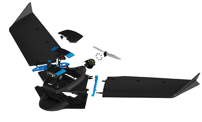
Every ounce counts on a drone. While a larger ground plane on a GNSS patch antenna improves its performance, the additional size increases weight — an unacceptable tradeoff.
The antenna’s location on the drone is another factor. It must be distant from motors and other electronic components that generate interference, which undermines positional accuracy. But remote locations are often off-limits because the antenna’s weight in those spots would disrupt the delicate balance drones require.
Drone-maker Parrot took these factors into consideration when choosing a GNSS antenna for its ANAFI USA drone. Although it weighs just 500 grams, ANAFI USA is designed to operate in winds up to 53 km/h.
To meet these challenges, Parrot chose the Taoglas DSGP.1575.15.4.A.02, a passive patch antenna that supports GPS L1 and Galileo E1. At 3.3 grams and 4 mm high, with a 15-mm2 footprint, the DSGP.1575 is designed for ultra-compact devices.
Key customers
High GNSS accuracy and reliability are critical for Parrot customers such as the French military, which recently ordered 300 ANAFI USA drones for reconnaissance and intelligence missions by its conventional and special forces.
Manufactured in the United States, ANAFI USA has also been selected by U.S. federal government partner organizations as part of the Blue sUAS project — the only UAV from a non-American drone manufacturer to be commercialized on the GSA Schedule, the buying platform of the U.S. military and civilian government agencies.
Police departments, federal agencies and firefighters in the United States and other countries also use ANAFI USA. The drone is also used for surveying, inspection and other commercial enterprises.
Tuned on a 50×50 mm ground plane, the DSGP.1575 operates at 1575.42 MHz with a 2.59 dBi gain. It uses ceramic materials — suitable for UAV applications because drones spend most of their time flying parallel with the horizon, a position in which ceramic antennas collect sufficient GNSS signals to meet performance requirements.
The DSGP.1575’s light weight and energy efficiency enable the ANAFI USA to carry bigger payloads and fly longer, up to 32 minutes compared to the consumer model’s 25 minutes.
“We chose Taoglas because of the quality of their antennas and their ability to tune an existing antenna in the mechanics of the product and to make it on a large scale for mass production,” said Meryam Abou El Anouar, Parrot technical leader for RF and Connectivity. “They are also known for their great experience with the GNSS propagation specificities as multipaths, so that is helpful when you try to achieve good GNSS accuracy.”
Taoglas provided Parrot with design and testing support in its design centers, as well as making regular visits to Parrot’s facility in Paris.
“Our engineering team managed to carry out tests at antenna and system levels,” said Baha Badran, Taoglas Global Antenna Technology director. “This includes passive antenna testing, in-chamber active antenna testing and GPS field testing of the drone. Each of these tests was carried out to ensure optimum GPS system performance was achieved, to give the highest possible positional accuracy for such an application.”
The support also helped Parrot minimize the cost and lead time for bringing the ANAFI USA to market.
Skyward, a Verizon company, and Parrot, a European drone group, are partnering to deliver Parrot ANAFI drones along with Skyward drone program management, flight-log sync and training to U.S. enterprises.
In particular, the new speaks to a widespread need among U.S. companies and public agencies for a secure, high-end drone manufactured domestically. Sold by Skyward, the ANAFI USA and training package gives enterprises a one-stop shop for building and scaling a drone program with aircraft, policies and procedures, training, and automatic flight log sync to the software platform to manage it all.
“ANAFI USA was designed to meet the needs of the most demanding professional users while offering enterprise data security and privacy,” said Henri Seydoux, founder and CEO of Parrot. “Now, combined with Skyward’s enterprise drone solutions covering training and integrated software platforms, professional users have access to one of the most comprehensive suites of hardware, software and services.”
In addition to its security benefits, Parrot’s ANAFI USA features 32x zoom 4K HDR video and thermal imaging capabilities. It is portable, weather-resistant and ready to launch in seconds.
“Now enterprises can maximize their investment in the ANAFI USA by pairing it with Skyward’s in-person and online operator training and robust management platform,” said Mariah Scott, president of Skyward, A Verizon company. “This is just the beginning of a strong partnership with Parrot. Look for continued feature integration and connectivity offerings as we move the industry forward together.”
Skyward users can automatically log flights from the Parrot FreeFlight 6 piloting application for the ANAFI, ANAFI Thermal and ANAFI USA drones with additional integration features coming soon to maximize the value of both platforms.
Drone maker Parrot is supporting French medical professionals facing the COVID-19 pandemic by helping Makers for Life design the MakAir respirator. This partnership comes as a part of their MakAir open source respirator project.
According to Parrot, it will be offering 500 engines for the launch of the MakAir project and will ultimately make 5,000 engines for the project. The engines will offer constant power, controlled vibrations, sufficient reliability and endurance to allow 24/7 operation for six weeks, Parrot added.
The MakAir project came to life when the COVID-19 pandemic highlighted a shortage of artificial respirators. Two other projects joined the cause to alleviate this issue. The first project, which brought together a number of manufacturers, was coordinated by Air Liquide and aims to increase the production of artificial respirators from 200 to 10,000 per year, starting in May 2020.
A second nonprofit project has spurred initiatives to create a simplified artificial respirator from standard components. Quentin Adam of the Makers For Life collective, in collaboration with Professors Antoine Roquilly and Pierre-Antoine Gourraud of the Faculty of Medicine of Nantes, and Erwan L’Her, head of the Intensive Medicine and Care Department of the Brest CHU, proposed a concept for a simplified artificial respirator.
The concept is based on using software to regulate inspiration-expiration, directly with the pneumatic system. The Nantes developer team turned to the CEA for industrialization of the concept, which had already been the subject of a proof of concept at the Brest University Hospital.
Parrot reaches milestone in U.S. Army Short-Range Reconnaissance drone program
Parrot has passed another milestone in the United States Army’s Short Range Reconnaissance drone program. As the final steps of this selection process, Parrot will participate in an operational assessment to support an Army production award decision. In anticipation of an increased demand signal from the Department of Defense, Parrot will start manufacturing prototypes of its dedicated drone in the United States, the company said.
“Parrot is honored to work with the DoD on this highly strategic project,” said Laurent Rouchon, vice president of security and defense at Parrot. “We have successfully met the high standards set over the last 12 months on the prototype efforts, and we look forward to entering this final phase and launching production in the USA.”
Global drone manufacturers 3DR, DJI, GoPro and Parrot today are forming the Drone Manufacturers Alliance, a coalition intended to serve as the voice for drone manufacturers and their customers across civilian, governmental, recreational, commercial, nonprofit and public safety applications.
“We will advocate for policies that promote innovation and safety, and create a practical and responsible regulatory framework,” said Kara Calvert, director of the Drone Manufacturers Alliance. “There are significant economic and social benefits to drone operations in the U.S., and industry must work with policymakers to ensure a safe environment for flying.
“The Drone Manufacturers Alliance believes a carefully balanced regulatory framework requires input from all stakeholders and must recognize the value and necessity of continued technological innovation. By highlighting innovation and emphasizing education, we intend to work with policymakers to ensure drones continue to be safely integrated into the national airspace.”
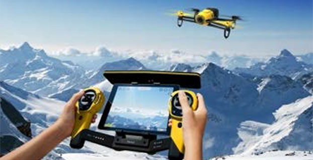
Parrot’s quadcopter Bebop Drone has Furuno inside.
Furuno Electric Co.’s latest multi-GNSS receiver module, GN-87, has been adopted for the new quadcopter Bebop Drone, made by Parrot SA. Parrot develops advanced technology wireless products.
The GN-87 can receive GPS, GLONASS, SBAS, and QZSS concurrently, which significantly improves positioning success rate and robustness against interferences by using different frequency bands, Furuno said.
Parrot Bebop Drone, equipped with a 14-megapixel fisheye lens camera, takes video and pictures in a 180-degree field. The drone integrates mechanical and digital systems, like shock absorbers that cushion engine vibrations and algorithms for an exclusive 3-axis image stabilization, meaning that the angle of the view remains fixed, without distortion, regardless of the inclination of the drone and movement caused by turbulence. The combination of numerous sensors gives the drone impressive stability and great maneuverability when piloted via Wi-Fi with a smartphone and a tablet, or with its Wi-Fi extender, Parrot Skycontroller.
Furuno’s GN-87 supports sensing for autonomous flying according to flight routes preset on the map application by user, automatic return to takeoff position, recording flight path data for 3D modeling on Parrot Academy map. According to Parrot, selecting Furuno’s GN-87 multi-GNSS receiver module enabled simple integration with a high-performance GNSS receiver module while guaranteeing high quality and high volume supply availability.