Tag: payload

  • UAVOS partnership to advance HAPS technology for high-altitude missions

    UAVOS partnership to advance HAPS technology for high-altitude missions

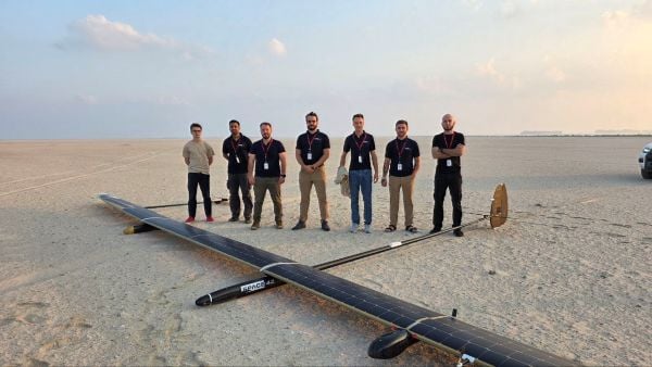
    UAVOS has successfully completed of a test flight of Mira Aerospace’s high-altitude pseudo-satellite (HAPS) ApusNeo 18, with UAVOS providing full engineering and technical support. A key objective of the flight was to evaluate the jointly developed optoelectronic, gyro-stabilized aircraft payload onboard device (POD) by obtaining imagery from altitudes between 3,000 and 12,000 meters.

    During the mission, the POD captured high-resolution imagery with precise geolocation data from an altitude of 12,000 meters, achieving a Ground Sample Distance (GSD) of up to two meters. The test took place in Abu Dhabi, UAE, and lasted continuously for 48 hours.

    “The data-relay station trials were conducted in preparation for upcoming commercial flights in Europe, planned for the coming months,” Aliaksei said.

    The optoelectronic gyro-stabilized aircraft POD is equipped with an innovative automatic temperature control system for  heating and cooling  electronic modules, ensuring reliable operation in the stratosphere at temperatures as low as -70°C under rarefied air conditions.

    The system also provides radio communication at distances exceeding 100 km. The gimbal’s optical unit allows observation within a ±90°C range with high-precision angular positioning. The payload housing features an aerodynamically optimized design, and the total payload weight is 3.6 kg.

    “The successful cooperation with Mira Aerospace reflects our commitment to continuously advancing the capabilities of both companies,” said Aliaksei Stratsilatau, founder and CEO of UAVOS. “We also continue to work toward our ultimate goal of leveraging the HAPS platform for multiple applications, including mobile connectivity, border monitoring, mapping, forest fire detection, and emergency response.”

    To extend the HAPS operational range, the test flight also incorporated a data-relay network based on ground modem repeaters. Each repeater is capable of providing a coverage area of up to 200 km.

    “The data-relay station trials were conducted in preparation for upcoming commercial flights in Europe, planned for the coming months,” Aliaksei said.

  • L3Harris passes critical design review for digital GPS IIIF payload

    L3Harris passes critical design review for digital GPS IIIF payload

    L3Harris logoThe design improves capabilities over the 70% digital payload used for GPS III space vehicles 1-10

    L3Harris Technologies passed the critical design review (CDR) phase in development of a fully digital navigation payload for the U.S. Air Force’s GPS III Follow-On satellites.

    CDR is a major milestone demonstrating the new payload’s design — specifically the fully digital Mission Data Unit (MDU) — is mature enough to proceed to final development, test and delivery.

    The new MDU is the heart of the navigation payload and will provide more powerful signals and ensure flawless atomic clock operations. It will also provide improved capabilities over L3Harris’ 70% digital MDU used for GPS III space vehicles 1-10 (GPS III SV 1-10).

    “The digital payload is flexible enough to adapt to advances in GPS technology and future warfighter mission needs,” said Ed Zoiss, president, Space and Airborne Systems, L3Harris. “Proceeding to the next stage in the GPS IIIF navigation payload development process moves the program closer to supporting evolving Air Force mission requirements.”

    In September 2018, the Air Force selected GPS III prime contractor Lockheed Martin to build up to 22 GPS IIIF satellites, which add even more capabilities and technology to the new GPS III satellites — including the new fully digital navigation payload. GPS IIIF SV11 and 12 are currently under contract.

    L3Harris is in a production cadence, having delivered to Lockheed Martin in July the eighth of 10 navigation payloads for the first 10 GPS III satellites.

    GPS III SV 01 and 02 launched in December 2018 and August 2019 respectively, and are performing well on orbit. GPS III SV03 is expected to launch in April.

    The remaining payloads are in various stages of integration with the satellites in Lockheed’s Colorado facility. L3Harris has provided navigation technology for every U.S. GPS satellite ever launched.

  • Harris receives GPS III Follow-On payload contract

    Harris receives GPS III Follow-On payload contract

    Harris Corporation has received a $243 million contract from Lockheed Martin to provide fully digital navigation signals for the first two GPS III Follow-On (GPS IIIF) satellites — to deliver stronger signals, with greater operational flexibility.

    Harris’ GPS IIIF fully-digital Mission Data Unit (MDU), the heart of the satellite’s navigation payload which generates the GPS signals, will provide more powerful signals, assure flawless clock operations for GPS users, and add flexibility to adapt to advances in GPS technology, as well as future changes in mission needs.

    It will provide improved capabilities over Harris’ 70-percent-digital MDU used for GPS III Space Vehicles 01-10 (GPS III SV01-10).

    The new MDU also offers the Air Force a smooth transition to its GPS OCX ground control segment. Harris will seamlessly port its digital signal design, minimizing both integration risks and associated costs.

    In September 2018, the U.S. Air Force selected Lockheed Martin, with Harris as its navigation signal partner, to build up to 22 GPS IIIF satellites, with a total estimated contract value up to $7.2 billion.

    The Air Force expects the first GPS IIIF satellite, SV11, to be available for launch in 2026.

    Launched aboard GPS III SV01 in December 2018, Harris’ first GPS III navigation payload began broadcasting navigation signals on January 8. While testing of the first-of-its-kind satellite continues, the payload has performed beyond expectations.

    Harris has provided navigation technology for every U.S. GPS satellite ever launched, enabling the reliable GPS signal that millions of people — including U.S. soldiers — and billions of dollars in commerce depend on every day.

  • Topcon announces payload updates at Xponential 2018

    Topcon Positioning Group’s Dave Henderson explains how Topcon’s products are integrated in Intel’s Sirius Pro fixed-wing UAV and Falcon 8+ drone at Xponential 2018 in Denver. Henderson also gives an overview of the new Topcon payloads that will be available for the Falcon 8+.

  • MicroPilot selects Simlat payload emulator for UAV cameras

    MicroPilot is working with Simlat to develop a pan, tilt and zoom payload simulation tool to help improve the camera-centric parts of MicroPilot’s autopilot software.

    Simlat is a provider of training systems for UAVs, enabling training on any platform with any payload for any mission. The tool Simlat has developed emulates a camera payload on a UAV, including simulated video, when set up with an “iron bird.”

    This allows more testing to be performed on the ground, and potential problems with the payload worked out before flight testing begins.

    “Flight testing is time consuming and expensive and simulation is an essential tool that reduces the amount of flight testing necessary to bring a drone to market,” said Howard Loewen, president of MicroPilot. “We are pleased to be working with Simlat to add this capability to our software development process.

    “MicroPilot is always looking for useful tools and features to integrate with our products in order to help deliver more capable and reliable products to our customers. This camera payload emulator is just one of many third-party tools we have incorporated into our testing and development and yet another way MicroPilot has shown its dedication to product quality and performance.”

    MicroPilot is an ISO 9001 autopilot manufacturer to bring to market an ISO 9001 sub-30-gram autopilot, triple redundant autopilot, and full-function general-purpose autopilot. MicroPilot offers a family of lightweight UAV autopilots that can fly fixed-wing, transitional, helicopter and multirotor UAVs.

  • System of Systems: GPS III payloads delivered

    QZS-2 signal analysis, QZS-3 launched

    The second satellite of Japan’s Quasi-Zenith Satellite System (QZSS) has started transmitting navigation signals. QZS-2, or Michibiki-2, was launched on June 1, 2017, and joins its predecessor QZS-1 (Michibiki-1), which has been in orbit since September 2010.

    Both satellites have been placed into inclined geosynchronous, elliptical orbits, which enable extended satellite visibility periods over Japan and are characteristic features for this regional navigation system.

    The third satellite QZS-3 was launched on Aug. 19, 2017, into a geostationary orbit. If all goes according to plan, a fourth satellite in an eccentric orbit will follow by the end of this year and complete the constellation.

    Read full analysis here.


    GPS Monitor Station Receivers Deployed

    Three of six new Lockheed Martin-developed receivers are now deployed at U.S. Air Force monitoring stations  to maintain the accuracy of GPS satellite signals.

    In June, the first Monitor Station Technology Improvement Capability (MSTIC) receiver became operational at Cape Canaveral Air Force Station, Florida. Upgrades continued at USAF monitoring stations  at Kwajalein Atoll and Hawaii. These upgrades from early 1990s technology are part of an overall effort to modernize the current GPS ground control system, known as the Architecture Evolution Plan Operational Control Segment.

    MSTIC software-defined radio technology replaces legacy receivers’ hardware-based application-specific integrated circuit platform. MSTIC leverages commercial off-the-shelf hardware without the need for custom firmware. Standard interfaces and architecture configurability simplify sustainment and enable MSTIC software to migrate to new hardware platforms as commercial vendors increase processing power, improve reliability and enhance cybersecurity. MSTIC enables remote application of mission-specific software updates to improve performance and enable reception of modernized GPS signals, according to the company.

    The three remaining GPS Monitoring Stations will be upgraded with MSTIC receivers by the end of 2017.


    The navigation payload before integration into the second GPS III SV, which now is in environmental testing. (Photo: Harris)

    GPS III Payloads Delivered

    Harris Corporation has delivered the third of 10 advanced navigation payloads to Lockheed Martin. The payloads will increase accuracy, signal power and jamming resistance for  GPS III satellites. They feature a Mission Data Unit (MDU) with a 70-percent digital design that links atomic clocks, radiation-hardened computers and powerful transmitters, enabling signals three times more accurate than those on current GPS satellites. The new payloads also boost satellite signal power, increase jamming resistance by eight times and help extend the satellite’s lifespan.

    The payload was integrated into GPS III SV03 over the summer.  The first navigation payload is integrated aboard GPS III SV01, which is in storage awaiting expected 2018 launch.

    Harris announced it is in full production and on target to deliver the fourth GPS III navigation payload to Lockheed Martin in fall. Harris is also developing a fully digital MDU for the U.S. Air Force’s GPS III Space Vehicles 11+ acquisition. The new MDU will be demonstrated in fall 2017 and provides even greater flexibility, affordability and accuracy versus existing GPS satellites.


    Next GLONASS-M Readied

    The Russian navigation satellite GLONASS-M 52 moved from ISS-Reshetnev Company’s assembly plant to the Plesetsk Cosmodrome launch site about 800 km north of Moscow in August. One of the system’s ground spares, it was built more than two years ago and stored awaiting launch. The satellite is due to launch in September.

    There are six GLONASS-M satellites in ground reserve.

  • Raytheon launches WAAS payload to improve GPS accuracy for air travel

    Raytheon launches WAAS payload to improve GPS accuracy for air travel

    Raytheon Company has launched its GEO 6 satellite payload into orbit for its 12-year mission. It is the latest payload to support the Federal Aviation Administration’s (FAA) Wide Area Augmentation System (WAAS), which enhances the reliability and accuracy of GPS signals for directing air travel.

    The Raytheon-developed payload is a key element of WAAS, which offers commercial, business and general aviation pilots more direct flight paths, greater runway capability and precision approaches to airports and remote landing sites without dependence on local ground-based landing systems.

    “This latest payload launch is the next step in our journey with the FAA to bolster navigation safety and efficiency for commercial and general aviation,” said Bob Delorge, vice president of transportation and support services for Raytheon Intelligence, Information and Services.

    In June 2016, Raytheon launched WAAS GEO 5, which was recently accepted by the FAA for integration into the operational WAAS system. Both WAAS GEO 5 and GEO 6 were launched to replace aging satellites and enhance GPS precision for the FAA. WAAS increases GPS accuracy from 10 meters to approximately two meters and supports nearly all of the national airspace.

    The WAAS GEO 6 payload is hosted on a geostationary satellite, SES-15, owned and operated by SES. The satellite was successfully launched May 17 from Arianespace’s Guiana Space Center in French Guiana aboard a Soyuz launch vehicle.

  • GLONASS Satellites Will Be ‘Made in Russia’ Only

    JSC “Russian Space Systems” (RCC), together with ISS Reshetnev, plan to remove imported components in construction of GLONASS satellites, according to an Izvestia article.

    Production of the advanced GLONASS satellite “GLONASS-K” is scheduled to begin later this year.

    According JSC CEO Andrew Tyulina, the company intends to stop the use of foreign electronic components as soon as possible. The plan is to have 80 percent of the satellites’ electronic components payload be domestically produced by 2019.

    The move seems to be spurred by international sanctions in response to Russia’s occupation of Ukraine. Following the occupation, the United States began to prohibit supply of electronic components to Russia, and the British company E2V failed to get permission to import equipment for the Russian space observatory Spektr-UV, Izvestia reports. Russia had difficulty securing components before then, however. In 2013, as relations with the U.S. cooled following Russia’s harboring of Edward Snowden and events in Syria, the U.S. State Department did not authorize a supply of components for the spacecraft Geo-IK-2. 

    The expected component supplier will be the largest designer and manufacturer of electronic components in Russia, Roselectronika, an entity that unites 112 companies, research institutes and design bureaus. The total investment in Roselectronika will exceed 210 billion rubles to 2020, including provision for modernizing industrial sites that produce electronic payloads for space.

  • ITT Exelis Awarded Payload Contract for GPS III Satellites

    ITT Exelis has been awarded a $32 million contract by Lockheed Martin to build the navigation payloads for the Global Positioning System III space vehicles three and four. Exelis announced in December 2011 that it had successfully integrated and performed the initial power up of the full-size payload prototype known as GPS III Non-Flight Satellite Testbed (GNST) Navigation Payload Element.

    “Exelis payloads have been on board every GPS spacecraft — a period spanning nearly 40 years. We are tremendously proud to be a part of the next generation of GPS satellites,” said Mark Pisani, vice president and general manager, Precision Instruments and Positioning, Navigation and Timing Systems, ITT Exelis Geospatial Systems. “Together with Lockheed Martin, Exelis is committed to providing our warfighters and commercial and civilian users more accurate and reliable capabilities that improve interoperability and jam-resistance.”

    Exelis was selected along with Lockheed Martin in 2008 by the U.S. Air Force to build the next-generation GPS III program. The GPS III team is led by the Global Positioning Systems Directorate at the U.S. Air Force Space and Missile Systems Center.

    “The GPS III satellites and their superior navigation payloads are critical to sustaining and modernizing the GPS constellation and we are focused on delivering these spacecraft affordably and efficiently to meet the needs of more than one billion users worldwide,” said Keoki Jackson, Lockheed Martin’s GPS III program director.

    Scheduled for first launch in 2014, GPS III satellites will deliver significant improvements compared with current GPS space vehicles. The GPS III program will affordably replace aging GPS satellites while improving capability to meet the evolving needs of military, commercial and civilian users worldwide. GPS III satellites will deliver better accuracy and improved anti-jamming power while enhancing the spacecraft’s design life and adding a new civil signal designed to be interoperable with international global navigation satellite systems.

    For more than 37 years, Exelis payloads and payload components have been on board every GPS satellite. They have accumulated more than 500 years of on-orbit life without a single mission-related failure.

    ITT Exelis Geospatial Systems, headquartered in Rochester, N.Y., is a global supplier of innovative  night vision, remote sensing, and navigation solutions that provide sight and situational awareness at the space, airborne, ground, and soldier levels. Key applications include image intensification and thermal imaging; advanced power supplies; multi-spectral image systems; weather and climate monitoring; space science; intelligence, surveillance and reconnaissance; GPS-based positioning, navigation and timing systems; and image exploitation software.