Tag: personal navigation device

  • Garmin Offers Trucking Navigator with Built-in Dash Cam

    Garmin Offers Trucking Navigator with Built-in Dash Cam

    The Garmin dezlCam trucking navigator has a built-in dash cam.
    The Garmin dezlCam trucking navigator has a built-in dash cam.

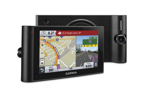
    Garmin International Inc. is offering dēzlCam, an all-in-one trucking navigator with a built-in dash cam that serves as an onboard eyewitness. Truckers can rely on firsthand video footage that continually records the drive and automatically saves video footage on impact.

    The dēzlCam provides custom truck routing for the size and weight of a driver’s truck as well as route warnings for bridge heights, weight limits, sharp curves, steep grades and more.

    “The dēzlCam is an innovative navigation solution for truckers,” said Dan Bartel, Garmin vice president of worldwide sales. “As technology evolves, so do the needs of truck drivers who spend their lives on the road. Truckers will like dēzlCam especially because of its premium trucking features combined with an integrated dash cam that records proof of road incidents and protects their driving reputation. The combination of these features adds significant value to our trucking community.”

    This premium truck navigator features a six-inch pinch-to-zoom display, a built-in dash cam with an adjustable swivel lens, and a magnetic mount to quickly secure or remove the dēzlCam from a driver’s truck. The built-in dash cam starts recording as soon as the dēzlCam is powered on, while the Incident Detection (G-sensor) automatically saves footage of collisions upon impact.

    Location, speed, date and time data can be optionally recorded allowing drivers to know precisely when and where an incident occurred. The Snapshot feature captures still images and provides truckers the freedom to remove the dēzlCam from their truck to take close-up pictures. Users can also play back driving footage directly on the device, or review on a computer using garmin.com/dashcamplayer.

    A comprehensive directory of preloaded TruckDown Locations and Services make it easy to find places highly rated by truckers. Drivers can filter trucking points of interest to find locations with their preferred brands or amenities.

    The dēzlCam is also bundled with Foursquare data that adds millions of new and popular points of interest to the navigator’s searchable database. Easy Route Shaping lets drivers modify a route to include preferred cities or roads by touching the screen. The Up Ahead feature displays a constant stream of nearby services, such as upcoming rest areas, fuel stations and restaurants.

    The dēzlCam also provides a history log to record fuel usage, IFTA mileage and hours of service, and displays mile-marker information, automatic time zone changes and alerts drivers of upcoming state and country borders.

    Created with safety in mind, the dēzlCam offers advanced navigation features that aid truckers in reaching their desired destination. Voice-activated navigation lets truckers control the dēzlCam with their voice, while Bluetooth technology allows for hands-free calling and pairing with a Bluetooth-enabled headset (sold separately). The dēzlCam is also compatible with the Garmin BC 30 Wireless Backup Camera (sold separately) to easily see behind a truck when in reverse. Spoken Garmin Real Directions can help drivers locate hard-to-find addresses with spoken directions that use recognizable landmarks, buildings and traffic lights. Active Lane Guidance with helpful voice prompts indicates the proper lane needed for a trucker’s route, while realistic Junction View imagery helps navigate complex interchanges with ease.

    The dēzlCam comes equipped with preloaded maps of North America with free lifetime map updates, as well as free HD Digital traffic that provides updates as often as every 30 seconds. Drivers can also download the free Smartphone Link app to access live weather radar on the dēzlCam and other real-time data services from a compatible iPhone or Android™ smartphone.

    The Garmin dēzlCam is expected to be available this month with a suggested retail price of $499.99.


  • TomTom’s New Devices Have Lifetime Maps, Speed Cameras

    TomTom’s New Devices Have Lifetime Maps, Speed Cameras

    TomTom is introducing Lifetime World Maps and Lifetime Speed Cameras to drivers with the launch of four new TomTom navigation devices.
    TomTom is introducing Lifetime World Maps and Lifetime Speed Cameras to drivers with the launch of four new TomTom navigation devices.

    TomTom is introducing Lifetime World Maps and Lifetime Speed Cameras to drivers with the launch of new TomTom navigation devices. Lifetime World Maps allow people to drive with maps from around the world at no extra cost, for the lifetime of their TomTom GO device2. Lifetime Speed Cameras let drivers know the locations of all speed cameras — both fixed and mobile, also for the lifetime of the device.

    The TomTom GO 510, 610, 5100 and 6100 feature a fully interactive screen to pinch, zoom and swipe — as well as a rich user interface, simplified user interaction, 3D Maps and a Click & Go mount. Drivers can also choose between a 5-inch or a 6-inch screen size, TomTom said. The new TomTom GO devices also include “Drive Home” and “Drive to Work” buttons in the main menu, for faster, simpler navigation.

    TomTom GO devices combine real-time traffic information with routing technology, to always offer drivers the fastest route available. TomTom Traffic covers all mapped roads and combines data from millions of data sources, from all over the world, to deliver traffic information so accurate that, with each new update, it can pinpoint the start and end of a traffic jam, precisely, down to 10 meters.

    “With the addition of Lifetime World Maps and Lifetime Speed Cameras to our new TomTom GO devices, we’re offering the most comprehensive package to drivers that we’ve ever launched,” said Corinne Vigreux, co-founder and managing director, TomTom Consumer. “Our aim is to help you avoid the jams, getting to your destination faster, wherever in the world you might be.”

    Lifetime TomTom Traffic is available via a smartphone connection on the TomTom GO 510 and 610. The TomTom GO 5100 and 6100 offer Lifetime TomTom Traffic via a built-in SIM with unlimited data and roaming at no extra cost.

    The new TomTom navigation devices are compatible with TomTom MyDrive4. For the first time, drivers can use their smartphone, tablet or PC to review real-time traffic information, plan routes, and send destinations to their TomTom GO, before they get in the car. Previously launched TomTom GO devices5 are also compatible with MyDrive though a simple software update. Find out more about TomTom MyDrive here.

    The new TomTom GO devices are now available online and in-store from €199.95.

  • Financial Results for Nokia HERE Show Growth

    Nokia has released its financial results for the fourth quarter and the full year 2013, which show growth for its HERE division, formerly known as Navteq.

    In the fourth quarter 2013, HERE had sales of new vehicle licenses of 3.2 million units, compared to 2.4 million units in the fourth quarter 2012 and 2.6 million units in the third quarter 2013. On a year-on-year basis, unit sales to vehicle customers increased primarily due to higher vehicle sales and higher consumer uptake of in-vehicle navigation.

    Sales to vehicle customers represented well over 50% of external HERE net sales in the fourth quarter of 2013, as well as in the fourth quarter of 2012 and the third quarter of 2013.

    The automotive success was partially offset by lower sales to personal navigation device (PND) customers. External sales for PNDs went up 10 percent, from €204 million in the fourth quarter of 2012 to €225 in the fourth quarter of 2013.

    HERE total sales decreased from €278 million to €254 million (10 percent), which Nokia said is because of the fast decline of internal sales (such as navigation and maps found in Nokia devices). Sales were €74 million at the end of 2012, compared to only €29 million for the end of 2013.

  • Have Apple and Google Killed Personal Nav Devices?

    Two prominent tech magazines are tolling the death knell for portable GPS devices today, spurred in large part by Apple’s announcement of Maps, its own mapping and GPS navigation service.

    “Apple made a number of significant announcements at its Worldwide Developer Conference (WWDC) yesterday, but one of the most insidious was its widely expected move to launch Maps, the company’s homespun mapping and GPS navigation service,” reads PC World’s article “Apple Moves to Kill GPS Devices, Reduce Dependence on Google.

    “The updated app marks the first time the iPhone will have free, voice-enabled GPS navigation. It also includes real-time traffic, Yelp integration, crowd-sourced traffic data (hello Waze), Siri support, and the ability to work in the lock screen. In a move to match Google, Apple is also working on 3D modeling for buildings and terrain data, which it will acquire by flying planes over U.S. cities.

    Wired Magazine was even more dire; its article titled “Apple, Google Just Killed Portable GPS Devices,” begins, “If it wasn’t obvious before, it’s crystal clear today. The dedicated portable GPS device is dead, with Apple and Google playing pallbearer to Garmin, Magellan and TomTom’s hardware businesses.

    “Between last week’s hastily organized Google Maps event, where the search giant showed off a new interface, new features and — most importantly for Android users — offline map downloading, and Apple’s new Maps app announcement at WWDC, a dedicated device for mapping and navigation comes across as superfluous. Or even worse, incredibly low-tech.

    Meanwhile, Apple signed TomTom for mapping services over Google Maps for its new operating system. Also read LBS Insider editor Kevin Dennehy’s latest column on Google’s plans to enhance its maps on Android.