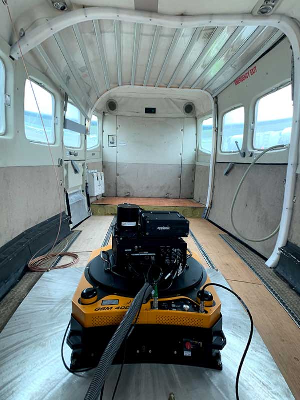
Atlantic — a remote sensing, surveying and consulting business — has purchased a Phase One Industrial 280MP large-format aerial solution to better serve its clients. The upgrade substantially increases Atlantic’s ability to efficiently capture a large area with extreme accuracy and quality.
Photo: Phase One Industrial
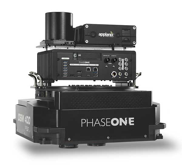
The massive Phase One Industrial 280MP aerial solution is a large-format camera system that easily integrates with smaller gyro-stabilized mounts creating a compact d lightweight system for use in a wide range of aircraft.
At its heart, the iXM-RS 280F is a dual-lens metric camera, with 90mm lenses for capturing RGB information, adding a near infrared (NIR) camera generates a four-band configuration, useful in agriculture, forestry and pipeline monitoring missions.
The iXM-RS280F camera has an image coverage width of more than 20,000 pixels whilst the cameras’ backside illuminated CMOS sensor supports very high dynamic range at 83dB. Its high light sensitivity provides superb image quality in challenging low light conditions, enabling operators to take advantage of more flight hours per day and more flight days per year.
“We’ve been using Phase One’s camera technology for over two years combined with our Optech lidar systems,” said Brian Mayfield, president and CEO of Atlantic. “We are very impressed with the technology and applaud Phase One’s innovative approach to designing a high-quality large format camera that produces exceptional results. The Phase One 280MP is yet another forward-looking technology resource that we’ve added to provide the most complete and cost-effective geospatial solutions for our clients.”
Phase One Industrial has launched a 280-megapixel aerial photogrammetric system, with an image coverage width of more than 20,000 pixels.
The large format enables unprecedented high-quality aerial survey productivity, the company said. Compact and lightweight, the new aerial mapping solution can reduce operating costs and produce better returns on investment than today’s traditional large format systems.
The Phase One Industrial 280MP Aerial Solution consists of an iXM-RS 280F large format camera, Applanix GNSS/IMU receiver (POS AV series), Somag gyro-stabilized mount (DSM 400), Phase One iX Controller and iX Flight Management software.
The system is a large format camera system that easily integrates with the DSM400 gyro-stabilized mount, creating a compact and lightweight system for use in a wide range of aircraft.
At the system’s heart is the iXM-RS 280F, a dual-lens metric camera with 90mm lenses for capturing RGB information, providing precision imaging. Adding a near infrared (NIR) camera generates a 4-band configuration, most useful in agriculture, forestry and pipeline monitoring.
The iXM-RS 280F camera generates a central projection image from two 150MP nadir images with equal ground resolution. The cameras’ backside illuminated CMOS sensor supports very high dynamic range at 83dB. Its high light sensitivity provides superb image quality in challenging low light conditions, enabling operators to take advantage of more flight hours per day and more flight days per year.
“Our 280MP Aerial Solution is a bold and innovative approach to solving customers’ demands for affordable and reliable aerial mapping performance,” said Dov Kalinski, general manager, Phase One Industrial. “Previously, opportunities in the aerial mapping business were restricted due to high cost of equipment and limited aircraft options. While pioneering superior image quality, Phase One Industrial is creating more profitable possibilities in this exciting and important market.”
Phase One Industrial, a provider of medium-format metric cameras and imaging solutions for aerial applications, has signed an agreement with AI-Survey GmbH, a developer of UAS survey packages, services and tailor-made solutions.
Together, the companies’ high-end products are opening up opportunities in drone-based high-accuracy mapping and inspection markets, the companies said.
Under this agreement, AI-Survey will support Phase One Industrial’s iXM range of cameras in the UAV market for high-accuracy mapping and inspection. AI-Survey offers fast and efficient, simple and reliable UAS solutions tailored for geodesists with millimetre imaging results.
“Our cameras exemplify AI-Survey’s mission to optimize, increase efficiency and inspire UAV mapping and inspection missions,”said Dov Kalinski, CEO, Phase One Industrial. “As an industry leader, we are confident that they will help our strategic efforts to evolve the industry through innovative solutions using Phase One Industrial technology.”
“We have developed long-term relationships and collaborations with many global technology partners, like Phase One Industrial,” said Carsten Rudolph, managing director, AI-Survey explains. “As an independent solutions provider, with such a large international network at our disposal, we are free to offer the best possible solutions to meet our customer needs and achieve their required accuracies. With Phase One iXM cameras, we now have the best global sensor for UAV mapping available, we believe.”
Phase One Industrial has expanded its RS and RSM lens offering with three new high performance lenses for high-altitude aerial photography and long-range aerial and ground inspection applications.
The 300mm AF, 180mm, and 150mm MK II lenses are designed to enhance the performance and flexibility of Phase One Industrial’s iXM-RS and iXM aerial camera series. Each offers precision imagery, taking advantage of the cameras’ ultra-high resolution backside-illuminated (BSI) CMOS sensors, to maintain a smaller ground sample distance (GSD) while flying at higher altitudes, the company said.
Phase One RSM 300mmAF. With the longest focal length in the line-up, this lens offers a 5 cm GSD from 13,000 feet. It fits both iXM and iXM-RS camera models and produces superb image quality by enhancing the cameras’ ultra-high resolution BSI CMOS sensors (3.76 µm pixels).
The lens is designed for both high-altitude 2D and 3D mapping and long-range ground inspection. The motorized lens offers a focus range of 10 m to infinity within which a predefined distance can be set remotely. A self-locking mechanism is built in to secure the focus position against vibrations.
5 cm GSD from 13,000 feet
10 m to infinity focusing range
f/8 – f/32 aperture range
1/2000 sec exposure time
RS Shutter reliability – 500,000 actuations
Rodenstock RS 180mm. Specified by Phase One and built by Rodenstock Photo Optics, Germany, this lens reaches a 5 cm GSD from 8,000 feet when used with the iXM-RS150F camera. The lens supports the camera’s ultra-high resolution BSI sensor for greater image quality and is integrated with a Phase One RS reliance shutter for speed and reliability. The RS 180mm enhances high-altitude aerial 2D and 3D mapping and improves efficiency in oblique configurations.
5 cm GSD from 8,000 feet
f/6.3 – f/22 aperture range
1/2000 sec exposure time
RS Shutter reliability – 500,000 actuations
Phase One RS 150mm MK II. A 5 cm GSD from 6,500 feet is achievable with the RS 150mm MK II lens. It complements the iXM-RS150F camera’s ultra-high 150-megapixel resolution BSI CMOS sensor for acquiring quality images for high-altitude aerial 2D and 3D mapping.
5 cm GSD from 6,500 feet
f/5.6 – f/22 aperture range
1/2500 sec exposure time
RS Shutter reliability – 500,000 actuations
Every Phase One Industrial lens is rigidly built for robustness against vibrations and shocks to meet RTCA DO160G standards, and is individually tested for performance and high-modulation across the whole image area.
A roundup of recent products in the GNSS and inertial positioning industry from the August 2018 issue of GPS World magazine.
OEM
IP Solution
With multi-constellation GNSS for internet of things (IOT) devices
The Dragonfly NB2 is a highly integrated and modular IP (internet protocol) solution optimized for Cat-NB2 (3GPP Release 14 eNB-IoT) that can seamlessly be incorporated into chips and modules by the multitude of companies looking to address the large and fast-growing cellular IoT space. GNSS hardware package. For customers developing NB-IoT products that also require GNSS capabilities, Ceva-Dragonfly NB2 includes a new power-optimized GNSS hardware package, with GNSS RF receiver and multi-constellation digital front-end. The GNSS package speeds up both acquisition and tracking tasks by up to 8 times compared to Ceva-Dragonfly NB1, enabling a host of popular NB-IoT use cases, including people, livestock and asset tracking and geofencing.
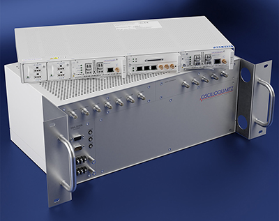
Provides timing accuracy and stability when GNSS signal is lost
Photo: Oscilloquartz
Oscilloquartz has launched its enhanced primary reference time clock (ePRTC) system to enable a high level of timing accuracy and stability, even when the GNSS signal is lost. The system provides a timing source for mission-critical transport systems, such as utility networks, government infrastructure and radio access networks, and provides the strict synchronization needed for LTE-A and 5G applications. Featuring the OSA 3230B ePRC atomic cesium clock connected to an Oscilloquartz clock combiner and grandmaster, the new solution offers the extremely stable frequency of a cesium clock with the UTC-traceable signal provided by GNSS. When combined with the OSA 5430, the OSA ePRTC system provides full hardware redundancy and multiple fan-out options including PTP over 10 Gbit/s.
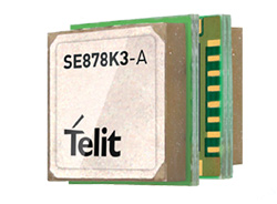
The SE878Kx-A series of GPS and GNSS integrated antenna receiver modules offer high performance, maximum reliability and low power consumption for consumer and business applications. The SE878K3-A and SE878K7-A are compatible with GPS, GLONASS, Beidou and Galileo and also enable device vendors to develop quickly and cost-effectively location-based IoT solutions for use in virtually any country worldwide. The SE878Kx-A series supports dual internal-external antennas to ensure connectivity when one is broken or compromised, along with a SAW filter to maximize jamming immunity. The modules are designed for mission-critical applications and other use cases where reliability is key, such as alarms, stolen cars or high-end asset tracking. The series also provides seamless integration with Telit’s cellular modules, including eCall/ERA-GLONASS compliant solutions.
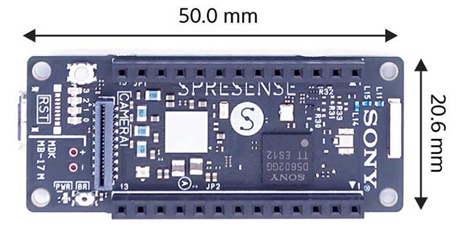
The Spresence main and extension boards are designed for internet of things (IoT) applications. The main board uses a multi-CPU structure equipped with Sony’s GNSS receiver (GPS+GLONASS) and high-resolution audio codec. A variety of systems for applications such as drones and other IoT devices can be built by combining the boards and developing the relevant applications. The boards’ software and hardware is available via open platform, allowing for a wide range of developmental possibilities. The main board can be used to control a drone using GPS positioning and a high-performance processor, voice-controlled smart speakers and low-power consumption sensing cameras. It also can be combined with sensors for use in systems that detect errors in production lines on the factory floor.
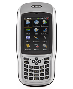
Designed for geopositioning, construction and mapping
Photo: Topcon
The T-18 handheld controller has a 3.7-inch sunlight-readable display, a 1-GHz processor and 1 GB of internal storage. For field data collection using Topcon’s MAGNET software, the T-18 offers a durable ergonomic solution with fast processing, excellent connectivity and a long (10-hour) battery life. It has a 3.5G cellular modem for connectivity with Topcon MAGNET solutions for sending and receiving data to the cloud company account. The modem also can be used for real-time kinematic (RTK) correction services. Other features include Bluetooth and an IP65 rating for dust and water protection in demanding job-site conditions.
The SXblue ToolBox is an Android application for SXblue GNSS receivers, enabling users to view and analyze the position data and metadata related to its location. The user can send commands that enable or disable some features, including systems in use, mask angle or differential angle, and constellation in use, including GPS, GLONASS, Galileo, BeiDou and SBAS. The SXblue ToolBox is also an NTRIP client capable of connecting to a NTRIP server for real-time kinematic (RTK) corrections, allowing the receiver to issue very accurate location information. The application can record, save and transfer raw data from the GNSS receiver, allowing post-processing on computers for surveying and geomatics professionals.The toolbox has been developed with special consideration for modern mobile devices and attention to user and dealer feedback. It includes a series of configurable audible and visual alarms for determining the thresholds of the information provided by the SXblue GNSS receiver.
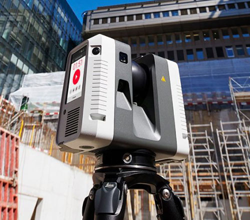
The Leica RTC360 laser scanner is equipped with edge computing technology to enable fast and accurate creation of 3D models in the field. It combines high-performance laser scanning, edge computing and mobile app technologies to preregister captured scans quickly and accurately. With the push of a button, two million points per second of high dynamic range imagery can be captured to create a full-dome scan in under two minutes. It features a visual inertial system that automatically tracks movements between setup positions. The scans captured can be combined and preregistered on a mobile device, where they can be viewed and augmented with information tags.
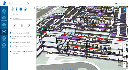
Location technology allows users to see rooms, gates and offices
Screenshot: Esri
ArcGIS Indoors is designed to enable interactive indoor mapping of corporate facilities, retail and commercial locations, airports, hospitals, event venues, universities and more. The solution applies the latest location technology to allow users to see and share where assets, rooms, departure gates and offices are located. It uses data streams, real-time processing and location intelligence tools to help businesses and other organizations understand how to better coordinate space and other resources with their facilities and campuses. Insights from sensor networks deliver real-time information to managers and executives through interactive dashboards, while visitors and employees can find useful information about the buildings they occupy. The solution also allows users to quickly access and explore critical business information, such as the location and status of fire extinguishers and their last inspection dates.
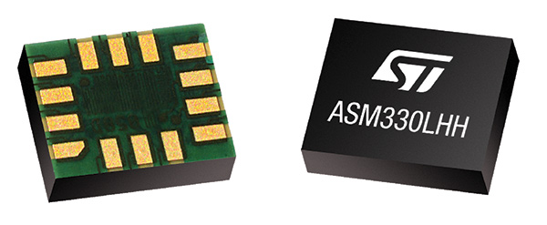
Meets demands for continuous, accurate vehicle location
The ASM330LHH module. (Photo: STMicroelectronics)
The automotive-grade ASM330LHH six-axis inertial sensor is designed for super-high-resolution motion tracking in advanced vehicle navigation and telematics applications. It lets advanced dead-reckoning algorithms calculate precise position from sensor data if satellite signals are blocked, such as in urban canyons, tunnels, covered roadways, parking garages or dense forests. Its advanced, low-noise, temperature-stable design enables dependable telematics services such as e-tolling, tele-diagnostics and e-Call assistance. Precision inertial data in six axes also meets the needs of advanced automated-driving systems. Automotive component manufacturer Magneti Marelli has selected the ASM330LHH for advanced telematics systems, to be fitted as original equipment by global automotive groups in upcoming vehicle ranges.
Esri and Waze smart cities partnership grows. (Image: Esri)
The free crowdsourced traffic and navigation app Waze is now fully supported by ArcGIS Online, where its live feed of mapped traffic alerts and other information, such as accidents, congestion and street damage, can be used in applications in minutes. Waze Live Alerts, available in ArcGIS Marketplace, is free to members of the Waze Connected Citizens Program. The program, a two-way sharing of publicly available traffic and road condition information, offers governments a stream of data, constantly updated in real time. This enables personnel to make data-driven infrastructure decisions and improves the efficiency of incident response.
Traffic engineers can use the data to analyze problems on the road and create targeted solutions.
Open-source platform for autonomous delivery and other iot
The AGL platform provides Mercedes-Benz Vans with the ability to create autonomous delivery robots. (Image: Daimler)
Automotive Grade Linux (AGL) is a collaborative cross-industry effort to develop an open platform for the connected car. Mercedes-Benz vans are using AGL as a foundation for a new onboard operating system for its commercial vehicles. The Mercedes-Benz “adVANce” initiative focuses on connectivity and internet of things (IoT) applications, innovative hardware solutions, new on-demand mobility and rental concepts, and fleet management solutions. The AGL platform provides Mercedes-Benz Vans with the flexibility to rapidly create tailored solutions for customers, including adding and connecting any kind of IoT component to the vehicle, such as sensors, automation controls and actuators. The new AGL-based operating system will debut on various Mercedes-Benz Vans prototype projects later this year.
eCyber is an integrated hardware-software product that protects vehicles against ransomware and other cyber-attacks. It can be installed in a vehicle by authorized parties, such as vehicle importers and fleet managers, in the aftermarket stage after the vehicle has left the factory, as well as by the OEM itself during manufacture. eCyber, a combined hardware and software solution in a compact box, is installed between the vehicle’s external communications device and the vehicle’s CAN (Controller Area Network) bus. It provides a secure gateway for outside communications to the CAN bus, allowing only communications with predefined parameters and values to go through. It blocks any unrecognized communications to and from the CAN bus, so no malicious digital communications can disrupt vehicle function.
Engineered for UAV-imaging missions, the iXM 100MP is a high-productivity metric camera with a range of high-resolution lenses. It is ready for integration with various UAV platforms, including Phase One’s DJI Matrice 600 Pro. The camera incorporates a medium-format sensor with backside-illumination technology, enabling high light sensitivity and extended dynamic range. Phase One also offers four new RSM lenses — with focal lengths ranging from 35mm to 150mm — to fit the new sensor’s 3.76 μm pixel size and 33 x 44 mm frame size. The lenses are available with either fixed-focus or motorized-focus functionality. The fixed-focus 35mm and 80mm lenses are especially suitable for surveying applications.
For quick approval of flights over controlled airspace
Screenshot: Skyward
Commercial drone operators in California and Hawaii — as well as a few areas in Nevada, Utah and Arizona — can get quickly authorized to fly in controlled airspace using the LAANC (Low Altitude Airspace Notification Capability) platform. Skyward is an FAA-approved airspace vendor. With Skyward, pilots with a Part 107 license can get permission to fly in regulated airspace in seconds compared to manual authorizations that can take months. This makes it significantly easier for businesses of all sizes, particularly in the construction and warehousing industries, to manage a fleet of drones to access valuable, cost-saving data. Skyward’s LAANC expansion includes airspace in the busy metro areas of Los Angeles, the Bay Area, San Diego, Las Vegas and more than 50 smaller air markets.
Phase One Industrial’s Steve Cooper offers a rundown on the company’s iXM-100MP metric camera at AUVSI’s Xponential in Denver. According to the company, the iXM-100MP was engineered for for UAV-imaging missions.
According to Phase One Industrial, the iXM 100MP is a high-productivity metric camera with a range of high-resolution lenses. Photo by Allison Barwacz
Phase One Industrial has launched the iXM series, an aerial camera platform driven by its fast medium-format imaging sensor.
Engineered for UAV-imaging missions, the iXM 100MP is a high-productivity metric camera with a range of high-resolution lenses. It is ready for integration with various UAV platforms, including Phase One’s DJI Matrice 600 Pro solution.
The iXM 100MP metric camera incorporates the first medium-format sensor with backside-illumination technology, enabling high light sensitivity and extended dynamic range. Fast, highly responsive, robust and weatherproof (IP53 compliant), the iXM 100MP delivers superior quality aerial imaging and flexible operation to satisfy diverse mapping, surveying and inspection applications, the company said.
In addition, Phase One announced four new specially developed RSM lenses — with focal lengths ranging from 35mm to 150mm — to seamlessly fit the new sensor’s 3.76 μm pixel size and 33 x 44 mm frame size, ensuring image sharpness across the entire FOV. The lenses are available with either fixed-focus or motorized-focus functionality.
The fixed-focus 35mm and 80mm lenses provide superior image radiometric quality, high ground resolution and large coverage, suitable for surveying applications.
The motorized-focus 80mm and 150mm lenses are designed for a wide range of inspection applications, including electricity poles, wind turbines, bridges, and other private-sector or government structures.
Motorized-focused lenses, having no external moving parts, enable a number of new uses for inspection applications where the focusing distance can be predefined based on flight planning, or by the operator, using a wireless remote control. With the motorized lens, the camera captures sharp and highly detailed images of multi-distance or 3D objects.
The cameras’ RSM lenses incorporate a new leaf-shutter technology, which supports 3 fps capture — with a speed of 1/2500 sec — while guaranteeing 500,000 actuations. The lenses are thermally stable to ensure consistent focus over a wide range of temperatures and flight altitudes.
With optics designed to exploit the full benefits of the new sensor technology, the lenses provide with greater productivity, flexibility and reliability, offering superb image quality.
The new iXM platform adds XQD high-speed storage technology to handle the sensor’s extremely fast frame rate. Also on all cameras, HDMI output from actual exposure provides UAV operators simple and outage-free feedback of actual view, exposures, and camera status in overlays.
In addition, the new platform includes USB-C and 10G Ethernet for versatility of connectivity to large UAVs and aircraft.
“Working with our UAV partners, we see a fast-growing market driven by great potential for time and cost savings over traditional inspection and surveying methods,” said Dov Kalinski, General Manager of Phase One Industrial. “With its new technology, design, and capabilities, the iXM 100MP promises to help start a new era in inspection missions with UAVs. Phase One Industrial continues to push technical boundaries to equip drones and larger UAVs with superior imaging technology — engineering advanced systems, cameras, and software — to help achieve that potential.”
The iXM 100MP and iXM 50MP metric cameras are available for advance order from Phase One Industrial partners worldwide with delivery in June 2018.
Phase One Industrial’s Jeff Bol discusses the company’s latest camera system, which includes the iX Controller Mark III and two 100 megapixel sensors, at Intergeo 2017, which took place Sept. 26-28 in Berlin, Germany.
Phase One Industrial has launched the 190MP Aerial System, built on dual CMOS sensors and the dual-lens iXU-RS1900 camera, which is capable of capturing images at 190 megapixels, according to the company.
An alternative to traditionally expensive large-format cameras, the system was designed with input from engineers and experts in photogrammetry to address challenging aerial applications such as remote sensing, monitoring, inspection and disaster management.
The system is equipped with an Applanix’ POS AV system, enabling direct geo-referencing of aerial images. It is also compatible with other GNSS/IMU systems. By integrating precision GNSS with inertial technology, POS AV enables precise determination of position and attitude, as well as the completion of geospatial projects in a more efficient and cost-effective manner.
The system’s accurate large image coverage, light weight and low power consumption make it compatible with most light aviation vehicles, including those that previously could not manage a large format system.
The iXU-RS1900 camera and 190MP aerial camera system will be presented at Intergeo 2017, to be held in Berlin, Germany, from Sept. 26-28. Phase One Industrial’s booth is in Hall 4.1, stand B4.002. Applanix is exhibiting in Hall 4.1, stand C4.050.
At the system’s heart is the IXU-RS1900 camera. It features two CMOS sensors and two 90mm lenses for capturing RGB information. Key imaging attributes include:
a small pixel size (4.6 µ)
large image area (16,470 x 11,540)
high image-capture rate of 0.6 second and exposure time of up to 1/2000 second.
An optional four-band configuration, adding a 50-mm lens for capturing near infrared (NIR) information, provides four-band (RGB, NIR) or color-infrared (CIR) imagery.
Integrated iX Capture software automatically generates distortion-free images and automatically performs an accurate matching of the NIR and RGB images.
The iXU-RS1900 can also be a standalone camera for photogrammetric work, as a component for lidar systems, or as part of a multiple camera array, such as a nadir camera for oblique systems.
“Introducing the Phase One 190MP aerial system demonstrates our continuing commitment to the aerial photography market,” said Dov Kalinski, general manager of Phase One Industrial. “The cooperation with leading partners in mount design, GNSS, and Flight Managements Systems enables Phase One to offer an innovative system at affordable pricing, and enables our customers to execute projects faster and at lower cost.”
190MP Aerial System Features
The entire system comprises many elements including:
iX Controller MK III: This is the central hub of the system. It controls the camera, the gyro-stabilizing mount and the GNSS/IMU system, and runs the capture application and the flight management system. The iX Controller supports dual monitors, so both the pilot and the operator are able to monitor and observe different views of the setup in parallel.
iX Capture: iX Capture is an aerial capture, control and image processing software with an intuitive interface that displays key information such as exposure settings, histogram, GPS data and frame count. It provides the operator with real-time feedback and ensures confidence that each image has been captured correctly.
Gyro Stabilized Camera Mount – Somag DSM400: Designed specifically for Phase One 190MP Aerial System, this mount has a low weight of 14 kg and high payload of 35 kg. It provides optimal stabilization of the system pod and allows highly efficient and precise image capturing under most flight conditions.
GNSS/IMU system: The Phase One 190MP Aerial System is equipped with an Applanix’ POS AV system, enabling direct geo-referencing of aerial images. It is also compatible with other GNSS/IMU systems. By integrating precision GNSS with inertial technology, POS AV enables precise determination of position and attitude, as well as the completion of geospatial projects in a more efficient and cost effective manner.
Flight Management System: Controlled and operated with ease, TopoFlight flight management system, integrated into the Phase One 190MP Aerial Camera System, enables the planning, positioning and sensors’ management – reducing aerial survey operational costs and increasing productivity. The 190MP Aerial System is also compatible with other flight management systems.
Availability and Pricing: The iXU-RS1900 camera and 190MP Aerial Systems are available now from Phase One Industrial partners worldwide. The iXU-RS1900 camera pricing starts at US$150,000; the 190MP Phase One Aerial System pricing starts at U.S. $280,000; and the190MP Four-Band Aerial System pricing starts at US$365,000.
Phase One Industrial discusses its recently launched products at Intergeo 2016, which was held Oct. 11-13 in Hamburg, Germany. Steve Cooper details the iXU-RS aerial camera system, which also is being released with a dual-camera option.