Pointfuse and Leica Geosystems, a Hexagon company, have established a global cooperation and entered into a development agreement. According to the companies, the agreement aims to streamline the use of reality capture in established digital construction, space management and visualization workflows.
This strategic cooperation demonstrates the shared focus of Pointfuse and Leica Geosystems to democratize technology and create intuitive and accessible reality capture tools that bring advanced project efficiencies to their users, the companies added.
To launch the new cooperation, Pointfuse developed a new version of its Pointfuse software, powered by Jetstream, that provides Leica Geosystems users with a Scan-2-BIM workflow within the Leica Jetstream ecosystem. Pointfuse is configured with tailored profiles specifically for Leica Geosystems 3D laser scanners, including the Leica Geosystems LGS file format. The adoption of the LGS file format enables Pointfuse to extract data contained within the LGS file to assist in the classification of building information and substantially automate the workflow process. This centralized solution ensures a simple Scan-2-BIM workflow for space and facilities management as a companion solution to the new Leica BLK2GO handheld imaging laser scanner, the companies said.
“With functionality and developments implemented specifically for Leica Geosystems users, Pointfuse, powered by Jetstream, harnesses the unique benefits of the Jetstream ecosystem with the power of Pointfuse to deliver a seamless capture-consume-collaborate workflow,” said Steve Salmon, general manager at Pointfuse. “This integrated solution overcomes many of the barriers associated with laser scanning and photogrammetry, through providing an optimised storage solution, instant data loading and production of intelligent outputs. This platform enables Leica Geosystems users to exploit the intelligence captured in the point cloud, easily share outputs, and produce deliverables that drive the advancement of workflows in the digital age.”
U.S. CAD is working with Pointfuse to help shape the future of point cloud processing software. This collaboration began upon U.S. CAD completing Pointfuse’s authorized training program.
U.S. CAD is an architecture, engineering and construction technology consultant that has 20 years’ experience in combining BIM content creation and 3D modeling with application development and configuration services. U.S. CAD is a Pointfuse distributor and has been working with Pointfuse to align Pointfuse’s software with its existing product and service portfolio, learn the full capabilities and ROI of the software, and discover product development functionality.
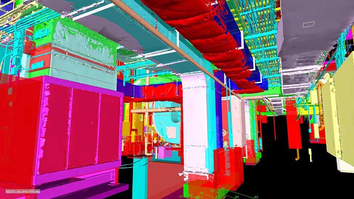
Pointfuse software converts millions of individual measurements captured by laser scanning, photogrammetry and mobile mapping systems into useable 3D mesh models. Pointfuse is unique in automatically segmenting the mesh into discrete, selectable surfaces by identifying objects based on their geometry and assigning unique identifiers to them, the company said.
“We already knew the addition of Pointfuse point cloud processing software to our market offering would release the power of laser scanning, photogrammetry and mobile mapping systems for a range of digital construction, facilities management and virtual design workflows,” said Jeff Rachel, president at U.S. CAD. “However, working with Pointfuse to complete the training program we now truly understand how to help and support our customers as they integrate these technologies within their organizations.”
Pointfuse has developed smart software that automates the identification and classification of objects for facilities management applications using data from mobile mapping systems like the new Leica BLK2GO.
Pointfuse software converts the millions of individual measurements captured by laser scanning and photogrammetry into useable 3D mesh models. The unique ability to classify objects within Pointfuse, both automatically and manually, has already had a huge impact on how as-built data is used within design and construction. It can now realize real time records for space utilization and optimization projects, reducing costs and speeding workflows within facilities management.
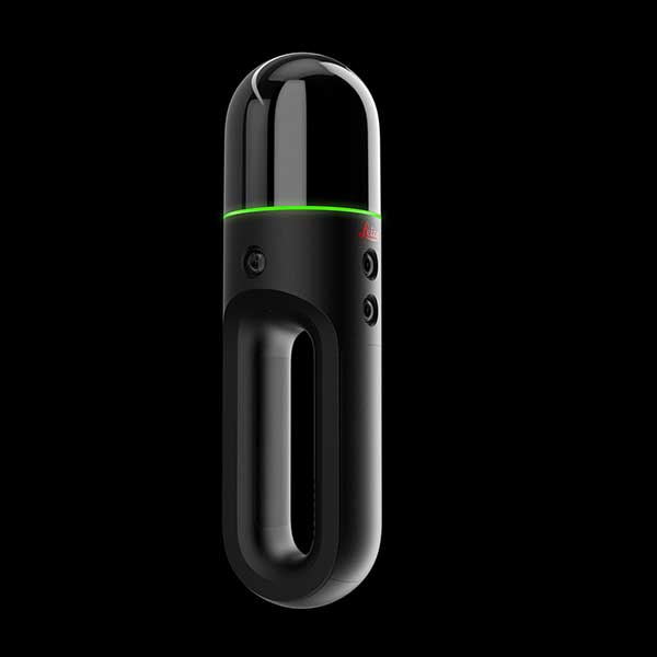
The Leica BLK2GO. (Photo: Leica Geosystems)
Pointfuse Simple BIM (sBIM) leverages the core functionality of Pointfuse — the segmented mesh model; automatically converting classified mesh models into “family” groups, such as walls, floors, doors, windows, etc. for use with popular downstream BIM and FM software. Pointfuse sBIM data can then be exported as IFC (Industry Foundation Class) parametrized objects and 2D floors plans and space management reports easily derived. Pointfuse sBIM also automatically calculates quantities, areas and dimensions in an easy to read PDF report.
“This ability to convert classified objects into family place holders has a huge impact on how as-built data is used within a Scan2BIM workflow with the potential for a real return on investment for facilities and space management applications,” said Mark Senior, regional sales director at Pointfuse. “The combination of ease and speed of data capture, as offered by modern hand-held indoor mapping systems like the newly launched Leica BLK2GO, with the automation of Pointfuse processing will release the potential of laser scanning across this sector.”
Pointfuse sBIM was developed in response to a large scale client opportunity that saw the scanning of millions of square feet of facilities with the final deployment of data in Archibus facilities management software using Autodesk Revit as a bridge. Early testing identified that 3D was as quick to create as traditional 2D workflows and exported data is in the region of hundreds of Kbs compared to the Gb volumes of the original point cloud. Taking the process one step further Pointfuse provides an accurate record of the as-built scene by allowing users to create Hybrid meshes combining Pointfuse models with the sBIM IFC container.
Pointfuse will be showcasing the sBIM functionality at the Autodesk University (AU) Expo which takes place Nov. 19-21 at the Sand Expo Convention Centre in Las Vegas, Nevada.
Pointfuse has developed smart software that automates the identification and classification of objects for facilities management applications using data from mobile mapping systems like the new Leica BLK2GO.
Pointfuse software converts the millions of individual measurements captured by laser scanning and photogrammetry into useable 3D mesh models. The unique ability to classify objects within Pointfuse, both automatically and manually, has already had a huge impact on how as-built data is used within design and construction. It can now realize real time records for space utilization and optimization projects, reducing costs and speeding workflows within facilities management.
The Leica BLK2GO. (Photo: Leica Geosystems)
Pointfuse Simple BIM (sBIM) leverages the core functionality of Pointfuse — the segmented mesh model; automatically converting classified mesh models into “family” groups, such as walls, floors, doors, windows, etc. for use with popular downstream BIM and FM software. Pointfuse sBIM data can then be exported as IFC (Industry Foundation Class) parametrized objects and 2D floors plans and space management reports easily derived. Pointfuse sBIM also automatically calculates quantities, areas and dimensions in an easy to read PDF report.
“This ability to convert classified objects into family place holders has a huge impact on how as-built data is used within a Scan2BIM workflow with the potential for a real return on investment for facilities and space management applications,” said Mark Senior, regional sales director at Pointfuse. “The combination of ease and speed of data capture, as offered by modern hand-held indoor mapping systems like the newly launched Leica BLK2GO, with the automation of Pointfuse processing will release the potential of laser scanning across this sector.”
Pointfuse sBIM was developed in response to a large scale client opportunity that saw the scanning of millions of square feet of facilities with the final deployment of data in Archibus facilities management software using Autodesk Revit as a bridge. Early testing identified that 3D was as quick to create as traditional 2D workflows and exported data is in the region of hundreds of Kbs compared to the Gb volumes of the original point cloud. Taking the process one step further Pointfuse provides an accurate record of the as-built scene by allowing users to create Hybrid meshes combining Pointfuse models with the sBIM IFC container.
Pointfuse will be showcasing the sBIM functionality at the Autodesk University (AU) Expo which takes place Nov. 19-21 at the Sand Expo Convention Centre in Las Vegas, Nevada.
A roundup of recent products in the GNSS and inertial positioning industry from the October 2019 issue of GPS World magazine.
OEM
Multi-GNSS receiver
Refined in the Galileo Online project for rail applications
Photo: TeleOrbit
The multi-GNSS receiver GOOSE, distributed by TeleOrbit GmbH and developed by Fraunhofer IIS, is now available in a new housing. GOOSE now also includes the new OS-NMA beta standard, available by the end of 2019, which was integrated within the research project PRoPART. GOOSE is a flexible, professional GNSS receiver development platform with an open software interface, which can be adapted to a variety of applications and application-specific correction services. The flexible development platform offers multi-system and multi-signal real-time processing; integrated antenna receiver combination (smart antenna); guaranteed stable phase center for all GNSS frequencies; and deployment in commercial PC or as an embedded platform. It allows deep coupling and vector tracking in real time; access to correlation values; and record and replay of IF samples. It also offers access to SBAS data including upcoming augmentation systems and differential augmentation systems. The platform has been refined in the Galileo Online project for specific usage in rail applications. It has also been further upgraded as a robust and reliable Galileo position sensor for autonomous truck applications.
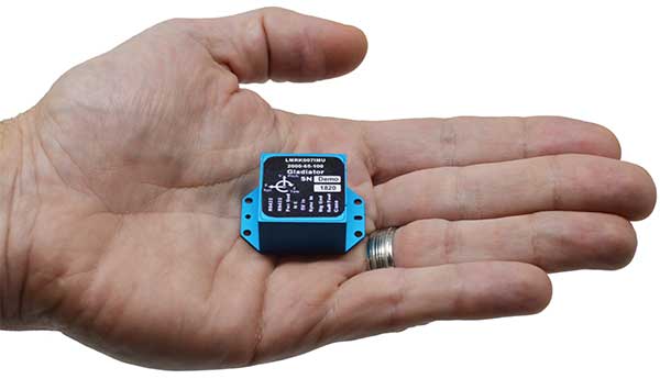
Low-noise performance for high dynamic applications
Photo: Gladiator Technologies
The LandMark 007 inertial measurement unit (IMU) combines low noise, high range sensors and Velox high-speed output in a rugged package measuring 0.7 inches square. With rate ranges up to 2000°/s and acceleration ranges as high as 200 g, the LandMark 007 IMU provides demanding, precision performance for a range of high dynamic, rugged applications. High-speed output data rates (up to 10 kHz) for measurement accuracy and flexibility are complemented by low-noise gyros and accelerometers. A development kit is available.
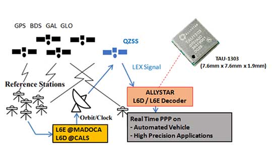
The QZSS L6 decoder module TAU-1303 supports tracking QZSS signals L6D (CLAS) and L6E (MADOCA). It can decode corrections data broadcast from L6D and L6E signals, and assist developers in applying the centimeter-level accuracy by PPP-RTK algorithm with the correction data. Within its 7.6 × 7.6-millimeter size, the module provides six channels to support tracking L6D and L6E at the same time. CLAS on L6D channel corrects satellite clock, orbit, code bias, phase bias ionosphere delay and tropospheric delay. MADOCA on L6E channel corrects satellite clock, orbit, code bias and phase bias. The TAU-1303 offers superior performance through an on-board 26-MHz temperature-compensated crystal oscillator (TCXO) and a reduced time to first fix because of its dedicated 32-KHz real-time clock oscillator. Based on 40-nanometer manufacturing processes of the Cynosure III GNSS chipset, the TAU-1303 has very low power consumption of less than 40 mA at 3.3V.
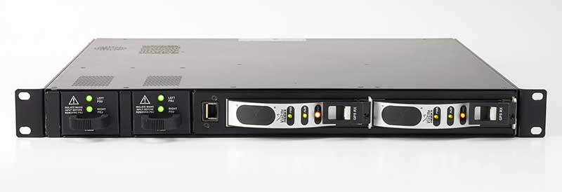
ViaLite’s new Local Integrated GPS Splitter was designed to minimize rack space. The unit provides a fan-out of GPS/GNSS signals within a local area, can accept optical inputs from up to four antennas, and has a 1000-1800-MHz frequency range. Though it has a height of only one rack unit, the system is useful for feeding timing and synchronization signals to single or multiple floors or rooms through eight to 32 optical fiber links with no system loss. It includes built-in simple network management protocol (SNMP) control as well as dual-redundant power supply units. Built for data centers, banking institutions, scientific research establishments, cellular test environments, fixed satcom stations, oil and gas platforms, and big data.
Pointfuse point-cloud processing software converts the millions of individual measurements captured by laser scanning and photogrammetry into 3D mesh models.The latest release features streamlined classification to ensure maximum efficiency and multicore processing for unlimited conversion power. The ability to classify objects and compare as-built objects with the design enables more accurate clash detection, reducing the number of false clashes being flagged. Intelligently optimized mesh models reduce the working data size by a factor of up to 100, making them easy to share with online 3D collaboration platforms, such as BIM 360, 3D Repo, Revitzo and Trimble Connect.
FieldGenius for Android, version 1.0, is multi-platform data-collection software built on Android OS. The brand-neutral data-collection software supports most popular GNSS sensors on the market. Features include dynamic data panels synchronized with map views, intuitive interface, simplified workflows and readily available data that surveyors require to make informed decisions in the field. Early adopters receive additional benefits and participate in the newly created MicroSurvey Technology Innovation Group.
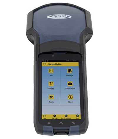
The SP20 handheld GNSS receiver offers innovative camera-enabled centimeter-accurate logging in an everyday GIS and survey tool. Rugged, lightweight and versatile, the SP20 delivers high-end performance. It is an easy-to-use tool that delivers accuracy from meter to centimeter, depending on the job. Android-based, it is useful for cadastral, construction or topographic surveys; a range of GIS jobs from data collection to inspection and maintenance; and non-traditional geospatial professionals. The 5.3-inch screen displays the new workflow using a camera to ensure 2D centimeter accuracy handheld and 3D centimeter accuracy with monopole setup.
TerraFlex users can now synchronize data directly to their on-premise Esri geographic information system without cloud services. The new software workflow — called offline data transfer — is possible through the integration of Trimble TerraFlex and the Trimble Positions Desktop add-in for Esri ArcGIS Desktop. TerraFlex is a field solution that enables mobile workers to easily collect, manage and edit their geospatial feature data. The new workflow provides an alternative to using Trimble cloud services for storing and transferring GIS feature data collected with the TerraFlex platform. In addition, TerraFlex field data collected via this workflow using a Trimble GNSS receiver can be post-processed directly inside the Trimble Positions Desktop add-in for improved positional accuracy. The mobile apps are available in Apple’s App Store and the Google Play store.The Trimble Positions Desktop add-in is available through the Trimble Geospatial distribution channel.
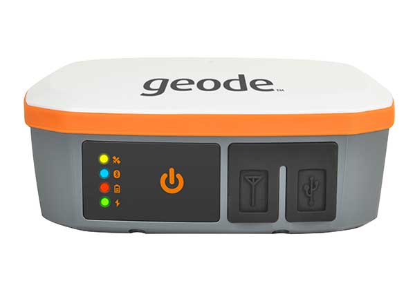
The Geode GNS2 sub-meter GPS receiver features connectivity with a range of iPhone and iPad devices, made possible by the Geode’s new MFi certification. Features of the Geode GNS2 include an IP-68 rating to withstand harsh environments, all-day battery life, multiple correction sources for precise real-time data, and an open interface that works with a wide range of Windows, Android, iPhone, and iPad devices as well as Juniper Systems’ handhelds.
Pointfuse has released the latest version of its advanced point cloud processing software that converts the millions of individual measurements captured by laser scanning and photogrammetry.
Featuring new streamlined classification to ensure maximum efficiency and multicore processing for unlimited conversion power, the new version of Pointfuse is set to transform workflows within digital construction, facilities management and virtual design applications.
“Pointfuse is designed to make the use of point cloud data more accessible by removing many of the traditional barriers to use,” said Mark Senior, regional sales director at Pointfuse. “Obstacles such as processing time and computer power, incompatibility within existing workflows and outputs files that are large and complex; these have all been obliterated with the latest Pointfuse release.”
Pointfuse now includes a new streamlined workflow which makes object classification easy, using templates and shortcuts to ensure maximum efficiency. This ability to classify objects within Pointfuse has had a huge impact on how as-built data is utilized within digital design workflows; being able to quickly compare specific as-built objects with the design enables more accurate clash detection, reducing the number of false clashes being flagged.
IFC (Industry Foundation Classes — an open format data model that is intended to describe architectural, building and construction industry data) templates can also be created and edited for specific applications. With applications including architectural, MEP and HVAC, selected objects can be classified and mapped to ensure compatibility with onward workflows.
Pointfuse also includes a new conversion engine which uses multicore processing to manage and enable unlimited point cloud conversion to provide real scalability. In addition, Pointfuse’s mesh models are intelligently optimized, reducing the working data size by a factor of up to 100, making them easy to share with online 3D collaboration platforms, such as BIM 360, 3D Repo, Revitzo and Trimble Connect.
“Using Pointfuse we can create intelligent 3D mesh models in a fraction of the time,” commented Ben Callan, BIM coordinator in global construction services company ISG’s UK Fit Out business. “This accelerated modelling and reduced risk of error contributes to a direct reduction in costs when compared against traditional methods of modelling and point cloud data analysis. The easy to use, easy to consume outputs are also paving the way for new applications of the data including existing versus design clash avoidance and checks of temporary works against required construction activities.”