Tag: Polaris Wireless

  • Polaris Wireless provides E911 z-axis for Schok flip phones

    Polaris Wireless provides E911 z-axis for Schok flip phones

    Image: Polaris
    Image: Polaris

    Phone users can now be located by emergency responders within one floor level inside multi-story buildings 

    Polaris Wireless, an innovator of high-accuracy software-based wireless location solutions, announces the company’s Z-axis location solution is commercially available nationwide.

    The technology — demonstrated to meet the 3-meter vertical location accuracy requirement of the Federal Communications Commission (FCC) — is integrated into Schok Gear’s newly released flip phones.

    Schok’s flip phones are typically used by consumers looking for a simple, yet powerful flip phone, that can now be accurately located in emergencies. Adding indoor and vertical location to these devices enables first responders to locate all wireless 911 callers with floor-level accuracy in multi-story buildings.

    “This is a major milestone for the 911 industry to deliver FCC-compliant Z-axis emergency location technology for users of feature phones” said Manlio Allegra, CEO and Founder of Polaris Wireless. “Working with Schok and their partners has been straightforward and it’s exciting to see for the first time the complete Z-axis solution commercially available in a flip phone.”

    “The Polaris Wireless location software was seamlessly integrated with our existing location and chipset vendors” said Samuel Gutiérrez, chairman and CEO, Schok, LLC. “Our Schok flip feature phone passed Tier I carrier acceptance testing, which for the first time included Z-axis location. Now our customers can be assured their accurate vertical location will enable first responders to find them faster in an emergency.”

    The vertical component of wireless location is critical in today’s environment when most 911 calls are placed by mobile phones and increasingly indoors, where location determination is particularly challenging. Accurate indoor wireless location is a game-changer for first responders to quickly get to where they are needed, regardless of the phone being used by callers. The Polaris Wireless Z-axis service is available seamlessly nationwide for public safety and commercial deployments.

  • Polaris joins Mark43 on location-enabled dispatch for emergency departments

    Polaris joins Mark43 on location-enabled dispatch for emergency departments

    Polaris Wireless is partnering with Mark43 to integrate 3D location technology into computer-aided dispatch systems for public safety organizations. Polaris Wireless is a provider of software-based wireless location solution.

    The joint solution will enable police and fire departments to track personnel and assets with pinpoint location, including indoors and in high-rise buildings, with floor-level accuracy. It delivers enhanced situational awareness and improved operational efficiency, which helps save lives and additional costs.

    Mark43 Computer Aided Dispatch and Automatic Vehicle Location. (Screenshot: Mark43)
    Mark43 Computer Aided Dispatch and Automatic Vehicle Location. (Screenshot: Mark43)

    Mark43 is a cloud-based public safety software provider. Its Mark43 CAD software provides mobile field units with precise information on laptops or tablets inside a vehicle. Built on AWS GovCloud, Mark43 works with police and fire departments to make sure web-connected units stay mobile in the cloud.

    With the addition of 3D location, command and control centers can direct firefighters to the correct floor in a structural fire or ensure SWAT teams enter at the correct floor of a high-rise building. In more routine situations, such as tracking officers or equipment in a large municipal headquarters, 3D location helps increase efficiency and allocate resources more wisely.

    Mark43 is purpose-built in the cloud to support interoperability with third-party systems and devices. This enables the Mark43 CAD to seamlessly integrate with the Polaris Wireless 3D Location Platform, which is cloud-based and available to application developers via a standard Android and iOS Software Development Kit (SDK).

    The platform relies on Polaris Wireless’ 3D location technology, which is able to locate devices on the vertical axis within 3 meters, floor level, utilizing all available signals and sensor measurements combined with the company’s patented algorithms.

    Screenshot: Mark43
    Screenshot: Mark43

    By operating independently, or “over the top,” of wireless carrier networks, the platform is universal, enabling applications to locate any device on any network — an important consideration when police and fire departments operate devices across several networks.

    “Giving command and control centers full visibility into first responders’ locations is crucial when it comes to emergency dispatch, where every second counts,” said Scott Crouch, Mark43 co-founder and CEO. “We are always aiming to integrate the best possible capabilities into our suite of offerings, and we look forward to working with Polaris Wireless to increase safety and efficiency for our first responders.”

    “Our 3D location is enabling new use cases in public safety applications with our partnership and integration into Mark43 CAD systems,” said Amir Sattar, senior vice president of operations for Polaris Wireless. “Dispatching police and firefighters to the precise location, including the correct floor number, represents a major advancement for public safety and a significant benefit for the communities they serve.”

    Polaris Wireless and Mark43 are exploring opportunities to trial the application with public safety organizations.

    Attendees at the NENA 2019 Event (June 14-19) in Orlando, Florida, can visit Mark43’s booth #321 to learn more.

  • 3D location platforms aids hotels, public safety indoors

    3D location platforms aids hotels, public safety indoors

    Orion Labs has released Advanced Location Services, a high-accuracy, carrier-independent 3D location platform delivered via Polaris Wireless.

    The service provides enterprises and public safety agencies with pinpoint location, indoors and in high-rise buildings, with floor-level and room-level accuracy, a difficult challenge in such GPS-denied environments.

    Orion indoor location example (Screengrab: Orion)
    Orion indoor location example (Screenshot: Orion Labs)

    The system enables customers to locate team members on the vertical axis accurate to three meters’ distance, to keep teams better-informed and better-connected, enhance team performance and improve worker safety. It works via Orion Sync, a standalone smart walkie-talkie, or as device as a service, in a smartphone form factor.

    “For our hospitality and retail customers, this offers the opportunity to greatly improve guest services and the experience they deliver. For public safety and healthcare customers, the integration has the potential to save lives,” said Jesse Robbins, founder and CEO.

    According to co-founder and CTO Greg Albrecht, “With 3D location tracking, hospitality teams can easily pinpoint where their guest service workers are located and identify the right team member for faster guest response for tasks like bringing up clean towels to a guest, fixing a TV or lightbulb in a guestroom, or clearing trays and carts,” he said.

    The system also protects lone workers. “When lone workers call for help, security teams can rapidly dispatch assistance without the lone worker needing to explain their location,” Albrecht said. “This is the same kind of technology that first responders are now adopting to accurately and rapidly locate 911 callers facing life-threatening situations.”

    Hotel workers suffer work-related incidents at a nearly 50% higher rate than other industries. (Photo: Dean Drobot/Shutterstock.com)
    Hotel workers suffer work-related incidents at a nearly 50% higher rate than other industries. (Photo: Dean Drobot/Shutterstock.com)

    Hotel workers suffer work-related incidents, encompassing physical injuries, medical emergencies, theft and sexual harassment, nearly 50 percent more than is the average across all other industries. Large metropolitan hotels can approximate small cities, with as many as 5,000 rooms, 12,000 guests, and 8,000 employees. Even a moderate-sized hotel can have hundreds of employees scattered across many floors, some remote from central operations. Locating employees quickly is key to preventing or minimizing incidents.

    Need maps. A fundamental challenge in developing 3D location awareness indoors is the need for accurate, detailed 3D renderings of the physical buildings themselves.

    “For most buildings, this has never been done before and is often an arduous task to accomplish,” Albrecht added. “However, there is a mapping process to allow for precise data points to be leveraged within the Orion platform. It’s a very simple task that can be completed even by the hotel staff at the time of setup. After that, it’s extremely simple to set up teams within the Orion System with a 3D view of their property that they can use.”

    The latest integration is undergoing tests at locations in Las Vegas and San Francisco, with more than 50 locations actively using the set-up.

    In March, Polaris Wireless, a provider of software-based 3D location solutions to wireless operators, law enforcement and government agencies, and location-based application companies, announced the commercial availability of its high-accuracy carrier-independent 3D location platform for application developers.

    In early 2018, Polaris Wireless participated in the CTIA’s Test Bed LLC Stage Z independent vertical location testing in San Francisco, Atlanta and Chicago, achieving floor-level accuracy.

  • Polaris Wireless launches 3D location platform for app developers

    Polaris Wireless launches 3D location platform for app developers

    Logo: Polaris WirelessPolaris Wireless, a provider of software-based wireless location solutions, announced the commercial availability of a high-accuracy carrier-independent 3D location platform for application developers. By integrating their applications to the new platform, developers can provide end users with pinpoint location, including indoors and in high-rise buildings with floor level accuracy, delivering enhanced situational awareness and improved operational efficiency, according to the company.

    Polaris Wireless has integrated its new platform with Orion Labs, Inc., a San Francisco-based company delivering instant and secure voice and location communication.

    The Polaris Wireless 3D location platform is cloud-based and is available to application developers via a standard Android and iOS SDK. It can locate devices on the vertical axis within 3 meters, floor level, utilizing all available signals and sensor measurements combined with the company’s patented algorithms. By operating independently, or “over the top,” of wireless carrier networks, the platform is “universal,” enabling applications to locate any device on any network.

    “Orion’s customers in hospitality, retail, healthcare, and public safety require pinpoint accuracy on a person’s location inside a building. Polaris Wireless’ platform helps us deliver that location capability, both for teams to see which floor they’re on or room they’re in, as well as to integrate location awareness with Orion Voice Bots and advanced AI-driven services,” said Jesse Robbins, Founder and CEO of Orion Labs.

    Orion will demonstrate its solution based on the Polaris Wireless 3D location platform at the International Wireless Communications Expo (IWCE) in Las Vegas March 4-8 in booth No. 3371.

    Polaris Wireless CEO, Manlio Allegra, will be participating in an IWCE panel titled “Impact of Enhanced Location Accuracy on Public Safety and 911 Services” on Wednesday, March 6 at 11:45 a.m.

  • Polaris Wireless achieves floor-level accuracy

    Polaris Wireless achieves floor-level accuracy

    In early 2018, Polaris Wireless participated in the CTIA’s Test Bed LLC Stage Z independent vertical location testing in San Francisco, Atlanta and Chicago.

    The company states that by using actual test call data to emulate active sensor compensation, its solution improved from 4.8- to 2.8-meter accuracy at the 80th percentile, which exceeds the commonly accepted definition of floor-level accuracy of under 3 meters.

    The testing focus was to evaluate barometric-based solutions in advance of the Federal Communications Commission (FCC) establishing a vertical location accuracy metric for compliance by wireless carriers in the Top 50 markets, beginning in 2021.

    Polaris Wireless was one of two technology vendors selected to participate and was the only solution tested in all buildings in all three cities: 48 buildings, 312 test locations and 55,592 test calls. The Polaris Wireless test included the widest variety of device and barometric sensor manufacturers.

    Polaris Wireless achieved an official Stage Z vertical accuracy of 4.8 meters, 80th percentile, with a minimal one-time compensation of the barometric sensor outside of the test cities. However, this one-time compensation did not present a true test of Polaris Wireless vertical location accuracy.

    Barometric sensor compensation is arguably the leading source of error in vertical location determination. During the test, Polaris Wireless did not enable active, in-market compensation of the baro sensor and instead relied solely on just a few test calls outside of the test market.

    Polaris Wireless vertical accuracy from CTIA test data. (Chart: Polaris Wireless)
    Polaris Wireless vertical accuracy from CTIA test data. (Chart: Polaris Wireless)

    After learning that the other vendor included active, in-market compensation, Polaris Wireless submitted a comparable set of results using the same methodology to the CTIA for consideration in the report. This data was drawn exclusively from actual test calls, in the period before final results were published, to emulate the original performance as if active compensation had been activated.

    These are referred to as “limited active compensation” results because sensor bias estimates were updated monthly instead of in real time. The figure shows the increase in Polaris accuracy when allowing for this active compensation.

    Polaris Wireless says it continues to improve on its three-dimensional accuracy for both public safety and commercial applications, and is exploring additional forums for independent performance evaluation.

  • Polaris Wireless to deliver E911 indoor location to Alaska

    Polaris Wireless, a provider of high-accuracy, software-based wireless location solutions, has signed a multi-year, multi-phase contract for delivery of a wireless location solution that complies with the Federal Communications Commission’s (FCC) most recent E911 wireless location accuracy mandate with The Alaska Wireless Network, a company wholly owned by GCI Communication Corp (GCI).

    The first phase of the contract extension includes the Polaris Wireless Evolved Serving Mobile Location Center (E-SMLC) with hybrid location software for LTE networks that complies with FCC-mandated indoor location requirements. Subsequent phases include delivery of additional location technologies and hybrid algorithms as cellular networks and mobile devices continue to evolve and become more capable.

    Polaris Wireless describes its hybrid location solution as inherently future proof to take advantage of improvements in cellular networks and mobile devices. 

    “We are excited to continue working with GCI in providing our software-based location solutions,” said Amir Sattar, vice president of global operations for Polaris Wireless. “Polaris takes great pride in GCI trusting us to provide GCI E9-1-1 callers with the highest level of location accuracy when and where they need it most.”

    “We have enjoyed a long-term relationship with Polaris Wireless delivering wireless E9-1-1 location solutions for many years,” said Gene Strid, chief technology officer of GCI. “As the carriers must now locate E9-1-1 callers in challenging indoor environments, we are happy to leverage Polaris Wireless’s technological innovation and commitment in delivering high-accuracy, software-based location solutions.”

    “Polaris Wireless E-SMLC product leverages all available and emerging technology to deliver the best location position accuracy we can for our subscribers’ emergency calls,” said John Myhre, vice president of wireless technology at GCI.

  • Per Enge appointed to Satelles board of directors

    Per Enge appointed to Satelles board of directors

    Per Enge, Professor and Director, Stanford university Center for Position Navigation and Time

    Satelles, a secure time and location solutions company, has appointed Per Enge to its board of directors. Satelles provides a time and location solutions delivered over the Iridium constellation of 66 low-earth-orbiting satellites.

    Enge is the Vance and Arlene Coffman Professor of Aeronautics and Astronautics for Stanford University, where he is also the director of the Stanford Center for Position Navigation and Time.

    “I am eager to join the Satelles Board of Directors and look forward to supporting the management team,” Enge said. “I am encouraged by the progress Satelles has made and continue to have confidence in the leadership team and future growth of the business.”

    Enge’s laboratory has worked with the U.S. Coast Guard to design a medium frequency radio system to broadcast differential GPS corrections to maritime users, and this system has been implemented as a worldwide standard.

    His laboratory also worked with the U.S. Federal Aviation Administration to develop WAAS, the Wide-Area Augmentation System that provides GPS integrity data to airborne users. Today, WAAS is carried by more than 100,000 aircraft, and similar systems have been implemented in Europe, India and Japan.

    Enge also serves on the board of directors of Amida Technologies, and he serves as a technical advisor to Polaris Wireless.

    He has received the Kepler, Thurlow and Burka Awards from the Institute of Navigation for his work. He is a Fellow of the Institute of Electrical and Electronics Engineers. He is a member of the National Academy of Engineering and a fellow of the Institute of Navigation.

    Enge received his Ph.D. in electrical engineering from the University of Illinois in 1983. In 2012, the U.S. Air Force inducted Enge into the GPS Hall of Fame.

    “It is with great pleasure that we welcome Per to Satelles Board of Directors,” said Michael O’Connor, Satelles CEO. “Per has distinguished himself as a technology innovator and brings to our board of directors deep expertise in global navigation satellite systems. His wealth of experience and expertise in GPS and other technologies adds new depth to our board as we continue to deliver Satellite Time and Location  to users around the world. We look forward to working with Per on our mission is to deliver trusted time and location solutions that augment and enhance existing solutions — including GPS.”

  • Polaris Wireless Closes Recapitalization Round

    Polaris Wireless, a high-accuracy, software-based wireless location solution company based in Mountain View, California, today announced that the company closed on a recapitalization of existing equity interests on April 25, 2013. As part of the recapitalization, Polaris Wireless completed a Series C financing with $10 million from Industry Ventures, a leading investment firm focused on the venture capital market, and Industry Ventures Managing Director Victor Hwang has joined the Polaris Wireless Board of Directors.

    “Industry Ventures seeks to invest in market leading growth companies and we believe Polaris Wireless is a clear leader in the wireless location market,” said Hwang. “We are very excited about Polaris Wireless’ strong growth trajectory and global presence, and look forward to working with Manlio Allegra and the senior team at Polaris Wireless in their next chapter of growth.”

    The investment by Industry Ventures also returned capital to Series A investor Draper Fisher Jurvetson (DFJ) and will also be used to fund Polaris Wireless’ future international growth.

    “We look forward to an exciting new growth chapter for our company with Industry Ventures by our side,” said Manlio Allegra, Polaris Wireless CEO and Co-founder.

    Polaris Wireles experienced a record increase in revenue and profitability in 2011 and 2012, driven by aggressive growth for its location solutions across the globe. Twenty-four U.S. wireless carriers, six managed services partners, and 15 international deployments now rely on Polaris Wireless location solutions to enable emergency call applications, lawful and mass location surveillance, and other location-based services.

  • Polaris Wireless Announces Contract in Europe-Middle East-Africa (EMEA) Region

    Polaris Wireless, maker of high-accuracy, software-based wireless location solutions, today announced a significant customer contract for a multi-million dollar deployment of the Polaris Wireless Altus and OmniLocate location surveillance product suite in the Europe-Middle East-Africa (EMEA) region. Polaris Wireless said it could not disclose the customer’s name at this time.

    The deal represents a major increase in Polaris Wireless business, and is the 14th deployment of the Polaris Wireless high-accuracy wireless location surveillance solution outside the U.S. and 38th globally. Polaris Wireless high-accuracy location solutions are a tool used to combat crime and terrorism, and have been extensively deployed since 2003 for public safety applications in the U.S. market.

    “We are very pleased to have achieved such a significant company milestone for high-accuracy wireless location surveillance solutions,” said Manlio Allegra, Polaris Wireless CEO and co-founder. “Our momentum is directly attributed to our unmatched ability to consistently deliver a 2G/3G-compatible (and very soon 4G) high-accuracy, highly-scalable, software-based location solution for public safety and surveillance.”

    The Polaris Wireless Altus application suite is a software-based surveillance solution that enables accurate mass location — providing users the ability to simultaneously locate all subscribers in a wireless network in real time and on a historical basis. This unique capability enables functions, such as target identification, tracking via geo-fence, and post-event analytics, which are vital to the anti-crime and anti-terrorism surveillance efforts of Polaris Wireless customers around the world, the company said.

    “This deal has contributed to the highest revenue-earning year in Polaris Wireless history,” continued Allegra. “We are exploring several additional opportunities in the international marketplace, and plan to increase our workforce in order to meet the growing demand.”

    To maximize its accuracy location performance, the Altus application suite is being deployed with the OmniLocate platform powered by Polaris Wireless Location Signatures (WLS), a software-based location method for dense urban and indoor environments. Polaris WLS is capable of locating a wireless device to within 40 meters for the majority of the calls and helps customers avoid the costly and time-consuming deployment and maintenance associated with hardware-based location solutions, the company said.

  • Enge Pilots Polaris Wireless/GPS Integration

    Polaris Wireless, a provider of software-based wireless location solutions, announced that Per K. Enge of Stanford University has joined its executive team as the chief technical advisor. In an interview with GPS World, Enge describes how combined wireless location signatures and GPS show an exciting way forward for location in dense urban environments, where the wireless solution actually improves as GPS degrades.

    Polaris Wireless, a provider of software-based wireless location solutions, based in Mountain View, California, announced that Per K. Enge has joined its executive team as the chief technical advisor to the company’s CEO, Manlio Allegra.

    Enge is a professor of aeronautics and astronautics at Stanford University, where he directs the GPS Research Laboratory. He is also is co-author of the textbook Global Positioning System: Signals, Measurements, and Performance and has received the Kepler, Thurlow, and Burka Awards from the Institute of Navigation (ION) for his work. He received his Ph.D. from the University of Illinois in 1983, where he designed a direct-sequence multiple-access communication system that provided an orthogonal signal set to each user.

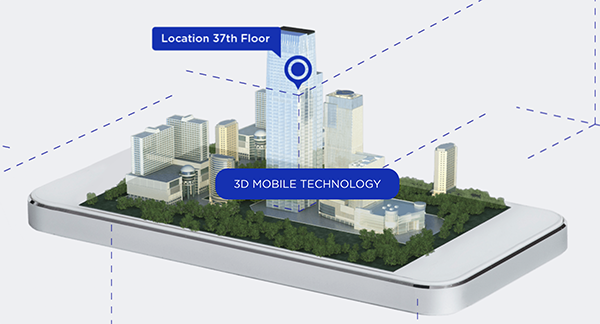
    Polaris Wireless’s core product is a Wireless Location Signature (WLS) for wireless network operators to identify the location of a wireless device to within 50 meters, at low cost, even in urban and indoor environments.  Polaris WLS is designed to scale as an operator’s network grows, providing location capabilities in 2G (GSM/CDMA), 3G (UMTS/CDMA 2000), and emerging 4G (LTE) air interfaces, as well as indoor technologies such as W-iFi, DAS, and Femtocells.  Founded in 2003, Polaris also counts among its customers law enforcement/government agencies and location-based application companies.

    In an interview with GPS World, Enge described how the Polaris location solution is actually enhanced by buildings, in direct opposition to the way GPS operates, and how he sees integration of the two technologies as leading the way forward for location-based services.

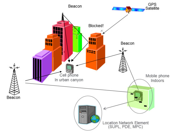
    “A cell phone general receives signals from 3 to 10 base stations, and is required to report the signal to noise ratio of those, even beyond base station used.  We backhaul that information into the Polaris server, where we do multilateration based on signal strength measurements. Imagery shows how RF signal stregnth varies in the city. Polaris uses the base station signals (similar to how Skyhook using Wifi access points), but the cell infrastructure use is better because it is always there and used by every phone, while Wifi receiver is not on all phones yet, just smartphones.

    “Marriage to GPS is very cool, because the Polaris technology loves buildings, they introduce the variation, the grain in the signal-strength map. It’s jagged, it’s got nooks and crannies, which are well-predicted by our propagation models. So those buildings enhance our technology.

    “We’ve got it pretty widely deployed, on 24 E911 networks, 24 wireless carriers that we have commercial relationships with in the United States, from quite big to more boutique providers.  Some are smaller, regional, other larger, like Verizon though not the total network.

    Michael Doherty, Polaris Wireless product marketing and communications director, added that “We also work outside the United States for location surveillance for governments who are also looking to deploy for commercial services.  The solution  is software-based, in the control plane of the handset, it is already within the handset, using network measurement reports (NMRs). Emergency caller location for cell phones, E911, is just the first of applications to come, it’s where we cut our teeth.”

    Polaris Wireless has been a research partner and sponsor at the Stanford GPS Research Laboratory that Enge directs. “Now I’ve stepped up my relationship with them, to start talking about getting the next level of accuracy.  They joined about 4 or 5 years ago, and funded the work of David De Lorenzo , a Ph.D. student who did first big set of measurements that we did on indoor navigation, on GPS penetration into buildings. On campus.  We’re aviation people, so this was a new area, good for us, we expanded into that area and got a lot smarter about how to navigate indoors.”

    De Lorenzo’s 2009 Institute of Navigation International Technical Meeting paper, “Design and Performance of a Minimum-Variance Hybrid Location Algorithm Utilizing GPS and Cellular Received Signal Strength for Positioning in Dense Urban Environments,” can be accessed here.

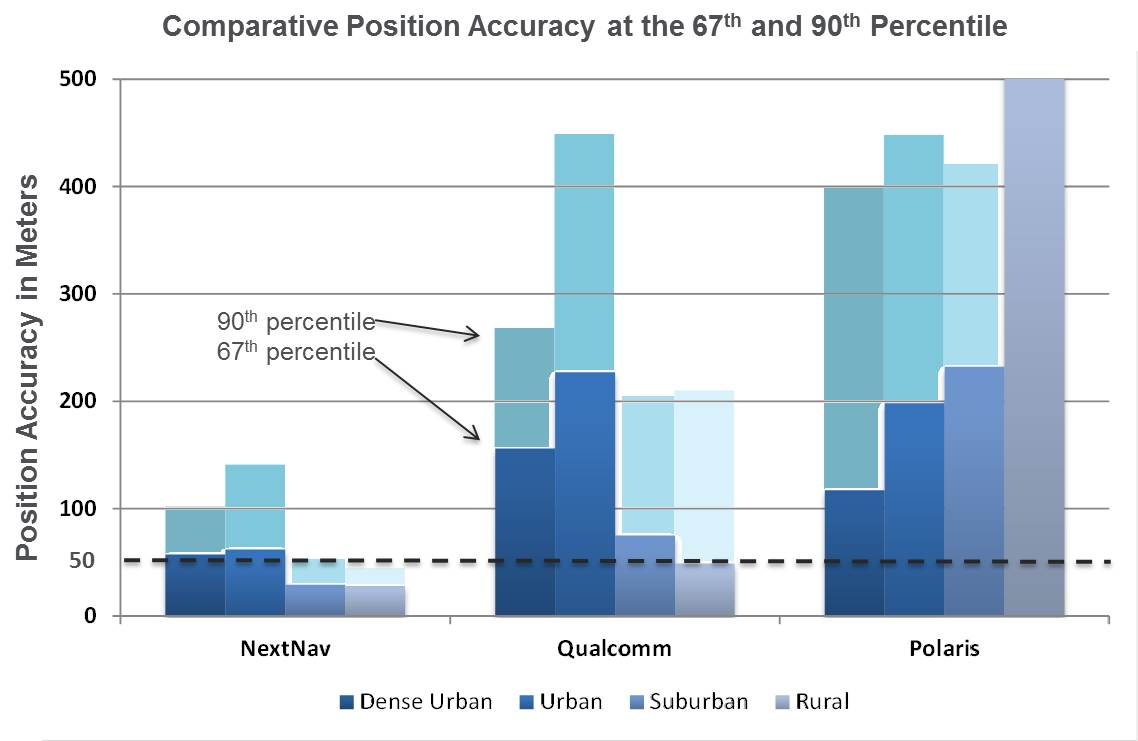
    “In New York, three-quarters of cell calls get 50-meter accuracy,” stated Doherty. “99 percent get 150-meter. Polaris solutions will improve that by a factor of 2. That’s a forward-looking  statement.”

    “We are entering a significant growth period for the company. From 2007–08 we saw our business start to take off, from core E911, take off in demand from overseas governments, for anti-crime, anti-terrorism. From 2007 to 2010, Polaris Wireless had an average 66 per increase per year in bookings, in contracts signed. That’s a healthy indicator of future revenues

    “Year over year 2010 to 2011, we saw a quadrupling of bookings, and  a revenue increase of 30 percent, as we started to see those deployments taking place, and revenues coming in as a result. we expect that trajectory to continue through 2012 and 2013. Again, forward-looking statements.”

    “During the deep recession, when U.S. governments were cutting back, we went overseas and were able to ride that wave.”

    As to particulars on directions that Polaris research and development might take under his advisement, Enge volunteered “One of the really big initiatives is the inclusion of map-matching, knowing that we’re probably on a street, especially if our velocity is appreciable, going beyond a snapshot solution fix, taking advantage of knowing where streets our.  We have cached that as a particle-filter problem, a Kalman filter associated with a set of hypotheses. When you have a sequence of snapshots, the particle filter is a very powerful way of putting that together.

    “How do we know if we’re in a building? By looking at the NMRs. Now, how high are we in that builidng, so that’s aided by the database.

    “The big core enterprise of Polaris, stripping away PNT, the strength is the underlying [cellular network] database.  Polaris is where the database meets navigation.  To make E911, law enformcement, navigation, all better.

    “One application I’m particularly keen on is for campuses.The risk for muggings is greatest when walking to a car in a distant parking lot. We’re thinking about how we can help that student when assaulted. You can’t pull out your phone and call E911 nor run to a blue tower [emergency phone].  But you might have your keys in your hand, so if we make it so you can just push a button on it, the NMR goes to an emergency center on campus, then we can be more helpful in helping that student.”

    Doherty inserted, “The beauty of our technology is that no one has to do anything. Our technology is capable of locating any device connected to the cellular network, as long as the device is powered on. It’s a software deployment, nothing to go out and deploy equipment cell tower by cell tower.  Nor can bad guys disable anything in the phone to void this service. Polaris’s solution resides in the network, not in the handset.  The confluence of signals in the network drives the solution.  There is no chip in the handset that can be disabled or turned off.  Whether GPS is enabled or not.”

    In a final comment on concerns for the future, Enge said, “Personal privacy devices, PPDs, the GPS jammers. I’m pretty worried about that. Unlike the Polaris technology, GPS technology can be slapped on someone’s car without an organization making sure the rule of law is preserved.  We’re hoping to make the PW technology complementary to GPS, so that when GPS is jammed, the PW solution will still provide a location.

    Doherty added, “It is complementary today. Cellular networks covers a large area. Take for example, downtown San Francisco: The wireless signature solution is absolutely the best to locate there. In wide-open country, GPS has an advantage. That complementarity is happening today.

    “Having Per onboard, we’re going to make that complementarity work better and better.”