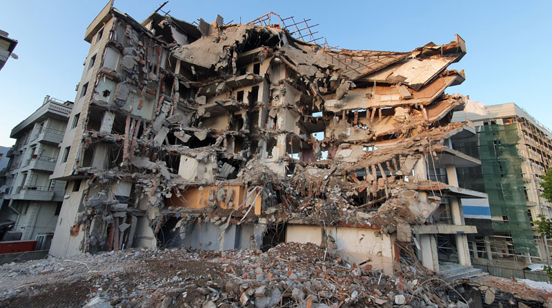
GMV is using high-resolution optical imagery as a part of emergency management efforts, to map the population and infrastructure of several cities in Turkiye after the 7.8 magnitude earthquake. The imagery of the aftermath is thanks to Europe’s Copernicus program, which keeps satellites and Earth observation services operational to support management and decision-making in different areas, particularly in the field of emergency management.
The satellite images show the challenge faced by rescue teams and reveal the massive amounts of destruction caused in cities across Turkiye and northern Syria. (Image: GMV)
GMV is one of the suppliers of Copernicus program infrastructure. GMV monitors the database architecture and ensures its integrity, analyzes the data required by the service chains, and identifies the most suitable technologies to keep the entire program operational.
GMV is working with the EU Civil Protection Mechanism’s Emergency Response Coordination Center to keep them updated on the ongoing emergency situation.
For more on the emergency satellite mapping, visit the Copernicus website.
There’s a saying that “Time stops everything from happening at once” — but what if it doesn’t?
What if we are in a world in which the U.S. is borrowing growth from the future by increasing debt, China has slowing growth and risky finances, many developing and southern European countries have combinations of economic malaise, recession, high and rising debt and/or double-digit inflation, the U.S. is in disruptive trade negotiations and Britannia waves the rules?
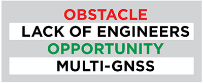
With the widespread influence of GNSS and the many technologies with which it is now associated or integrated, attention is increasingly turning to the prospects for and nature of applications, where the platform is the message.
At the same time, economic, political and technological developments are leading to pressing issues in the areas of spectrum management, spoofing and jamming, cybersecurity, privacy, net neutrality, spectrum competition, national security export controls, product liability, space debris and crowding and militarization of space.
This environment places unprecedented demands on management attention and agility.
The structure of industries is being transformed. Mergers and acquisitions are reminiscent of the U.S. consolidation of the 1960s, which led to increasing market power among large corporations until economic weakness and new technologies disrupted the leaders.
This time the changes are taking place on a much more global scale, but nevertheless are becoming large enough to influence markets and competition in location-based sectors and other industries.
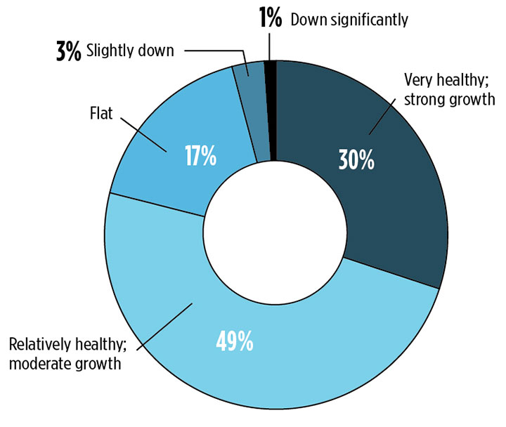
Describe the market for GNSS products/services in your industry sector as of today. (Source: GPS World 2018 State of the Industry survey)
Market Intelligence. Executives will need good market intelligence and foresight to keep ahead of fast-developing technology trends in research and development and shifting markets.
Despite opportunities from renewed economic growth, decisions regarding capital spending and research and development face not only the usual uncertainties about economic paths, interest rates and markets but also an additional extraordinary range of risks across the globe. These range from military and economic warfare, terrorism and hostage taking to financial excesses to appropriation of intellectual property and state subsidies by competing nations.
In the U.S., where politics is highly polarized, upcoming congressional and presidential elections will certainly lead to large, unexpected changes. U.S. policies could be extended or reversed, depending on election outcomes, in the areas of taxation, regulation, and levels of defense spending, with implications for modernization of GPS satellites, ground systems and military user equipment.
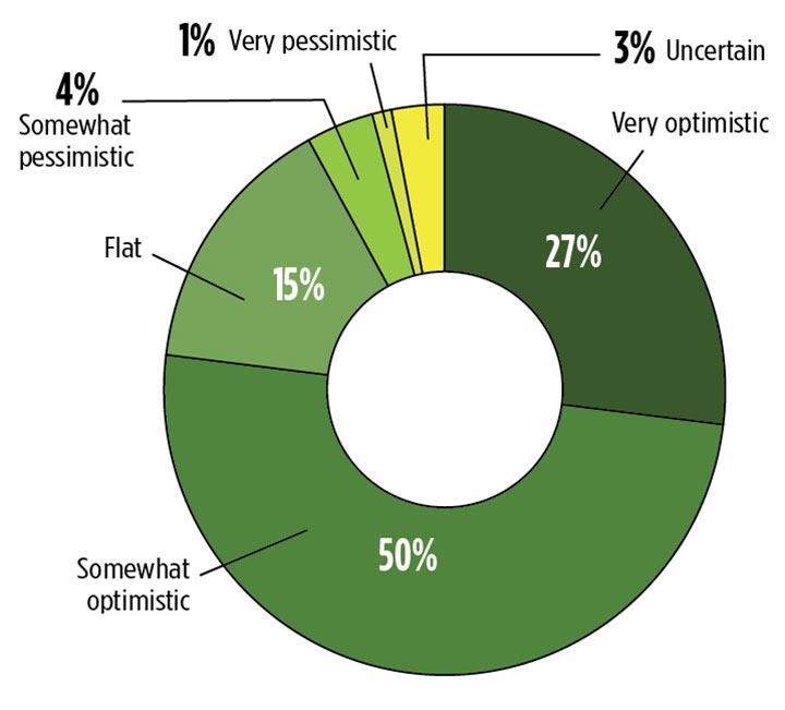
What is your business outlook for 2019? (Source: GPS World 2018 State of the Industry survey)
Population Factor. The workplace will have to adjust to further slow population growth. With half of baby boomers yet to retire, job opportunities will continue to be above normal, but so will losses of some skills. The availability of scientific and engineering personnel also will be affected by immigration policies for a long time. In addition, tight labor markets mean issues of labor quality as well as skill.
Moreover, social and political issues in the workplace are becoming more contentious around race relations, gender equality, sexual harassment, privacy and fairness, with some tech employees pressing companies to reject some types of government business.
Europe. In the U.K., choice of a hard Brexit could be disruptive for many years despite some possible long-range benefits. There is no getting around the need to renegotiate vast numbers of restrictions, policies and standards. A “soft Brexit” does not appear likely to yield the hoped-for economic benefits of separation and will not fully reduce the costs of the rift.
The European Union faces the challenge of paying for Galileo and other defense and space programs as well as costly social programs without the contributions of the U.K. At the same time, increased populism is leading to unexpected changes in governments and policies that can reduce cooperation among nations.
Currency. A strong dollar and rising interest rates in advanced countries can create problems for emerging economies. Trade and currency fluctuations complicate supplier decisions about pricing and the location of production.
The leaders of China and Russia are entrenched, and in the absence of major economic disruptions they will be able to carry out policies without periodic reversals. China’s ascendancy in technology, including in GNSS and space, will increasingly challenge the West.
Trade. Politics and economics are joined at the hip, and no less so when it comes to trade. The question at the moment is whether tough trade negotiation tactics will devolve into a sustained trade war, undoing the benefits of the U.S. tax cuts and bringing economic harm to the rest of the world.
The international Monetary Fund warns that: “Our modeling suggests that if current trade policy threats are realized and business confidence falls as a result, global output could be about 0.5 percent below current projections by 2020.” While some see trade tensions, nationalism and populism as the start of an effort to renegotiate the world order, for now developments are likely to be much less far-reaching.
While the U.S. economy is currently strong and likely to remain so for a while, risks have been building and economic and financial cycles have not been repealed. Budget pressures from future economic and political reversals can stall spending on defense, space and GNSS, defer GNSS capabilities and stretch deployment schedules.
All this means turbulence and air pockets down the road. Fasten your seatbelt. FY 2019 is about to take off.
For more results from the 2018 State of the GNSS Industry, see this page.
As part of the Open Geospatial Consortium’s (OGC) Testbed 13, the OGC is requesting information to identify, assess and gather the current state and available geospatial data and services in the Europe and Middle East regions that may be used to support the development, testing and demonstration of OGC standards and technologies advanced during Testbed 13.
OGC Testbed 13 participants will implement services, access data, and demonstrate capabilities using the services and data identified during this request for information (RFI).
The overarching theme for Testbed 13 is mass population migration. The Testbed aims to understand and document how information sharing and safeguarding tools and practices — including open geospatial standards — can enable cross-domain interoperability on an international level for structured communication exchange and border surveillance to assist law enforcement and humanitarian aid operations.
The demonstration scenario for Testbed 13 will focus on addressing challenges related to the coordination of multi-regional/national operations arising from the current exodus of people from the Middle East to Europe. This includes any messaging related to the displacement and mass movement of populations in response to conflict.
As an OGC Innovation Program initiative, Testbed 13 will investigate and develop new or enhanced OGC web service or encoding specifications over a wide variety of technology work areas. These technologies will be tested and demonstrated in an architecture and a deployed environment in support of the mass migration theme, as shown in the following diagram:
A wide variety of source data or data provider services available for public use are needed to support the scenarios and use cases associated with this testbed. As such, OGC is looking for your help in providing us with information on the availability of these data and services.
The following is a partial list of types of source data or services, required over the area of interest, that could support the development of, and testing in, Testbed 13:
Map data and/or services
Feature data and/or services, such as road networks, rivers, water bodies or water sources, jurisdictional boundaries, etc.
Satellite imagery and/or services
Predictive model related data, such as base and ancillary data as well as outputs of predictive models
Medical and Health facilities and locations (or could be part of other feature data sources or services)
Recommendations for additional source data or services that provide data of various types across the region of interest, are available for public use, and could support the scenario, development, and testing in Testbed 13, are welcome and encouraged.
For more information on Testbed 13, view the Call for Participation. The RFI is available for download. Instructions on how to submit responses to, or questions concerning, the RFI are available in the download.
Smartphone users now have access to Field Notes—Earth, a new mobile app from Esri that employs the power of geography to answer questions about locations throughout the world. Built using Esri’s AppStudio for ArcGIS, the free app allows anyone to discover interesting facts about population, nature and physical landscapes for any location on Earth.
“Field Notes—Earth leverages the tremendous capabilities of geographic information to describe the world in detail,” said Esri president, Jack Dangermond. “Tools like these update and transform our understanding and expectations in ways that help us be wiser citizens of the planet.”
With an intuitive design available on Android and iOS devices, the app gives users the option to discover answers to questions about their hometown, current residence, or any place of interest. It lets them compare these findings to an additional location.
After selecting an initial place via current location, search, or by dropping a pin on a map, the app reveals geographic insights for three categories — Natural, Physicaland People. Sample questions include:
How crowded is it in this location?
How close am I to a recent earthquake area?
What is the predicted 2050 change in average temperature?
“Whether you are relocating, are an educator looking for a new teaching resource, or just curious about the world around you, the app reveals insights into the complexity of humanity’s relationship with Earth for everyone to enjoy,” said Sean Breyer, ArcGIS content program manager at Esri.
In addition to exploring 18 questions, users can click on any answer for more details and to learn how the selected locations relate to the rest of the world’s landscape and populations. The app reveals, for example, that the majority of people live in very hot climates and more than 40 percent of the Earth’s soil is poor for most crops.
Esri’s Content Team created the app using AppStudio for ArcGIS, which lets you build an app once and have it automatically ready for Android, iOS, Windows, OS X, and Linux.
Esri announced that the Strauss Center’s Climate Change and African Political Stability (CCAPS) program has implemented Esri technology to view how climate change impacts vulnerable populations in Africa. CCAPS created the dynamic mapping tool in partnership with AidData for use by researchers, policy makers, journalists, and citizens. Users can visualize any combination of CCAPS data on climate change, conflict, and aid on a map to discover how different forces overlap or intersect.
“This mapping tool allows policy makers to analyze data from multiple sources at once, providing integrated analysis of the drivers and responses related to security risks stemming from climate change,” said Francis J. Gavin, director of the Strauss Center.
According to the announcement, the tool is already being used in the country of Malawi for a solution that tracks and reports on the country’s external funding. Aid information is mapped along with data on climate change vulnerability and incidents of conflict. This sheds light on whether aid is effectively targeting regions where climate change or conflict poses the most significant risk to the sustainable development and political stability of the country.
“Climate change poses an enormous threat to the livelihoods of millions of Africans,” said Jean-Louis Sarbib, CEO of Development Gateway. “The level of risk, however, is not evenly spread and certainly doesn’t respect national boundaries. To ask critical questions about how development assistance can reduce vulnerability, you need hyperlocal data on climate and also on aid-funded interventions. This is what the new CCAPS mapping tool shows in a digestible, interactive way.”
Esri reported that by integrating CCAPS research on climate change, along with existing datasets such as topographic maps, imagery, and thematic information on conflicts, the CCAPS mapping tool aims to provide the most comprehensive view possible of climate change and security in Africa.
“The great work of these organizations is a real game changer for the development community,” said Jack Dangermond, president of Esri. “Being able to create a tool that allows people to communicate with others all over the world using maps is powerful. I am impressed with the work being done and excited to see what they will think of next.”