Tag: position fix

  • Kite-blown Antarctic explorers make most southerly Galileo positioning fix

    Kite-blown Antarctic explorers make most southerly Galileo positioning fix

    News from the European Space Agency

    A kite-blown science expedition to the interior of Antarctica has made the most southerly positioning fixes yet made with Europe’s Galileo satellite navigation system.

    The Inuit WindSled is a multi-part sledge the size of a lorry, complete with mounted tents and solar power panels, pulled through the ice using a mammoth 150 sq. m. diameter kite. (Photo: Inuit WindSled via ESA)
    The Inuit WindSled is a multi-part sledge the size of a lorry, complete with mounted tents and solar power panels, pulled through the ice using a mammoth 150 sq. m. diameter kite. (Photo: Inuit WindSled via ESA)

    Their measurements not only confirm Galileo performance at extremely high latitudes, but also offer knowledge of space weather events overhead. In particular they offer insights into the ionosphere — the electrically active upper layer of Earth’s atmosphere — above the southern continent, and the performance of Galileo software to correct ionospheric interference.

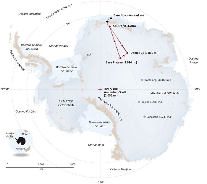
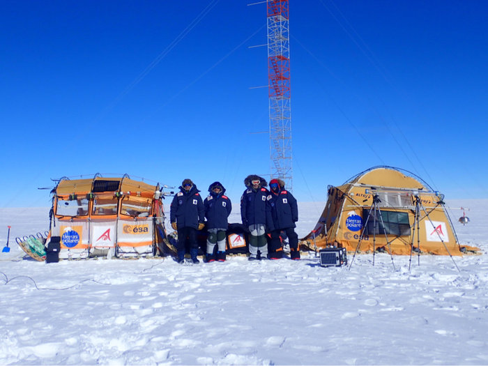
    The four-person expedition left Russia’s Novolazarevskaya Base on 12 December last year. For more than 40 days they made their way to Dome Fuji, a 3810-meter-high ice dome in Eastern Antarctica — one of the coldest places on Earth. After reaching the high point on 21 January, they are now back at the Russian base.

    The Inuit WindSled is a multi-part sledge the size of a lorry, complete with mounted tents and solar power panels, pulled through the ice using a mammoth 150 sq. m kite. (Graphic: ESA)
    The Inuit WindSled is a multi-part sledge the size of a lorry, complete with mounted tents and solar power panels, pulled through the ice using a mammoth 150 sq. m kite. (Graphic: ESA)

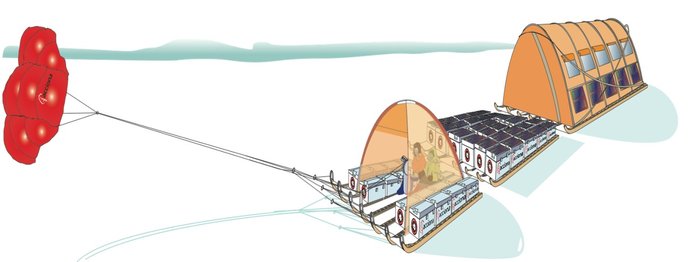
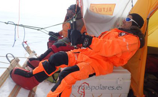
    The “Antarctica Unexplored 2018-2019″ expedition, mounted by Spain’s Asociación Polar Trineo de Viento, is employing a unique zero-emission vehicle specially designed for polar exploration. The Inuit WindSled is a multi-part sledge the size of a lorry, complete with mounted tents and solar power panels, pulled through the ice using a mammoth 150 sq. m kite.

    The Windsled’s inventor, Ramón Larramendi, is also the expedition leader. “This marks the first time we’ve climbed the Fuji Dome in a vehicle driven by the wind — everyone who reached there before relied on motorised vehicles. So this is also the first time we’ve traveled more than 2,400 km with more than 2,000 kg of cargo using a vehicle that does not pollute the Antarctic continent,” Larramendi said.

    “We are also doing this in collaboration with ESA, among other scientific institutions, which is very important because it allows us to demonstrate this polar eco-vehicle has excellent possibilities for enabling science in the interior of the Antarctica continent,” Larramendi said.

    The four-person "Antarctica Unexplored 2018-2019" expedition left Russia’s Novolazarevskaya Base on Dec. 12, 2018. For more than 40 days they made their way to Dome Fuji, a 3810-meter-high ice dome in Eastern Antarctica — one of the coldest places on Earth. (Graphic: ESA)
    The four-person “Antarctica Unexplored 2018-2019” expedition left Russia’s Novolazarevskaya Base on Dec. 12, 2018. For more than 40 days they made their way to Dome Fuji, a 3810-meter-high ice dome in Eastern Antarctica — one of the coldest places on Earth. (Graphic: ESA)

    The expedition carries a total of 10 scientific experiments from different research institutions, covering fields such as climate change, meteorology and astrobiology. ESA’s involvement with the expedition is the Galileo Experimentation and Scientific Test in Antarctica (GESTA) project.

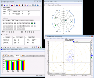
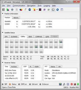
    GESTA involves regular positioning fixes being made over the course of the expedition for all satellite navigation constellations in all kinds of weather and geomagnetic conditions encountered. ESA provided the satnav receiver, with GMV in Spain contributing an advanced signal recorder for data analysis.

    One of the important aspects of the study is the monitoring of the ionosphere in such high latitudes during low solar activity. Ionospheric interference can degrade satellite navigation performance, and its incidence is linked to solar activity.

    The expedition team with their Inuit WindSled at the high point of Dome Fuji. Note the ESA logo on the left tent of the WindSled. (Photo: Inuit WindSled via ESA)
    The expedition team with their Inuit WindSled at the high point of Dome Fuji. Note the ESA logo on the left tent of the WindSled. (Photo: Inuit WindSled via ESA)

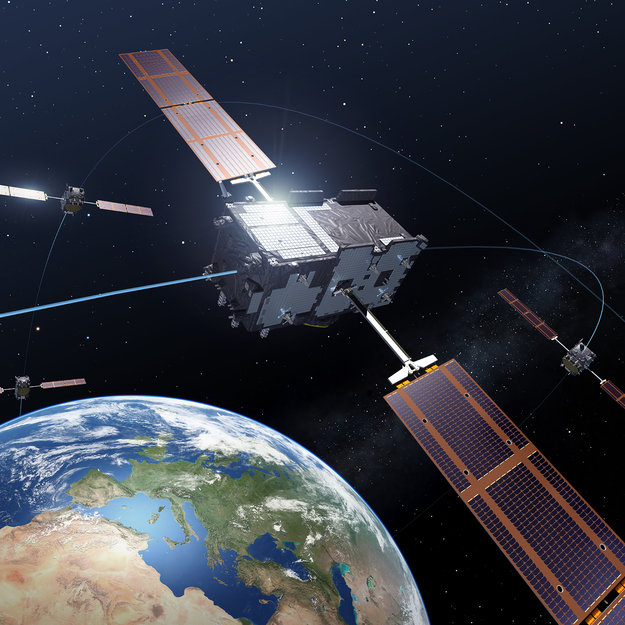
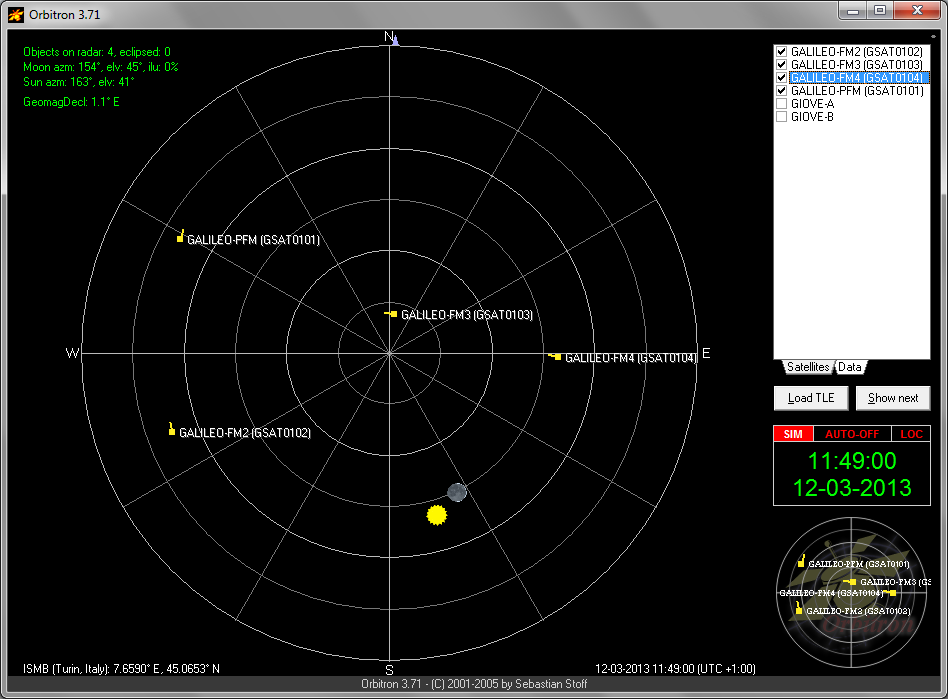
    GESTA is overseen by ESA’s Galileo Navigation Science Office, led by Javier Ventura-Traveset. “We are very pleased with this pilot scientific experience, having been able to collect Galileo measurements all over the expedition trip as planned,” said Ventura-Traveset. “The expedition reached latitudes near 80 degrees south, to our knowledge the most southerly latitude measurements ever-performed in-situ with Galileo in its current near-complete constellation status.

    “We have also collected data from all other global satellite navigation systems and all available different frequencies, which will allow us also to assess multi-constellation solutions and compare their performance on these conditions. The expedition team kept in continuous contact via satellite with our office, allowing us to plan their activity, asking, for example, for dedicated data collections during space weather relevant events.”

    “Once the expedition data are delivered, we will be able to assess Galileo positioning, navigation and timing capabilities at polar latitudes and how they are influenced by space weather events during low solar activity,” said Manuel Castillo, system engineer at the Galileo Navigation Science Office. “In particular, we will analyze if the occurrence of coronal holes is correlated with observed ionospheric interference. Coronal holes are open areas in the Sun’s outer layer, the corona, that allow the solar wind to leave the Sun and reach Earth, triggering moderate geomagnetic storms.

    “At this moment in the 11-year solar cycle, with the Sun close to minimum activity, full-scale solar storms are not frequent, but the ongoing communication between the WindSled team and the Galileo Navigation Support Office allowed us to coordinate measurement times during the three minor geomagnetic storms the expedition experienced during the trip.”

    A coronal hole in the Sun, observed by NASA's Solar Dynamics Observatory on Jan. 5, 2019. (Photo: NASA)
    A coronal hole in the Sun, observed by NASA’s Solar Dynamics Observatory on Jan. 5, 2019. (Photo: NASA)

    The coronal holes triggering these geomagnetic storms were monitored, meanwhile, by Sun-watching missions such as NASA’s Solar Dynamic Observatory, the NASA-ESA SOHO and ESA’s Proba-2.

    ESA’s Galileo Navigation Science Office is based in European Space Astronomy Centre, ESAC, near Madrid. It was set up in 2016 as a joint initiative between ESA’s Science and Navigation Directorates, coordinating scientific opportunities through interaction with the scientific community and the independent GNSS Science Advisory Committee.

  • Combined orbital Galileo-GPS position fix achieved aboard ISS

    Combined orbital Galileo-GPS position fix achieved aboard ISS

    News from the European Space Agency

    Europe’s satellite navigation system Galileo is already in use worldwide, usable by itself or in combination with the U.S. GPS. Now a combined Galileo–GPS positioning fix has been achieved in space — aboard the International Space Station — through an ESA–NASA collaboration.

    In April, the chest-sized SCaN (seen left of center with an antenna on top) was used to make the first combined Galileo-GPS positioning fix in orbit from the ISS. (Photo: ISS)
    In April, the chest-sized SCaN (seen left of center with an antenna on top) was used to make the first combined Galileo-GPS positioning fix in orbit from the ISS. (Photo: ISS)

    Low-Earth orbiting satellites routinely make use of satellite navigation signals to pinpoint their position in space and allow their paths through space to be fixed with extremely high accuracy, known as “precise orbit determination.”

    So far, such positioning has mainly been performed using GPS, but this new test proves it can also be achieved on a dual-constellation basis with both GPS and Galileo — as well as through the sole use of Galileo.

    The experiment is based on the use of a reconfigurable NASA receiver called the Space Communications and Navigation Testbed, SCaN, attached to the exterior of the ISS.

    ESA’s Navigation Support Office, based at its ESOC control centre in Darmstadt, Germany, teamed up with its Radio Navigation Systems and Technology team, located at its ESTEC technical centre in Noordwijk, the Netherlands, and Italy’s Qascom company to develop the techniques, software and firmware required for the experiment, which was passed to NASA’s Glenn Research Center in Ohio for upload to the receiver.

    The International Space Station. (Photo: ESA)

    “SCaN is a versatile software-defined radio receiver in space for both telecommunications and navigation testing, delivered to the Station back in 2012,” said ESA radio-navigation engineer Pietro Giordano. “It made it possible, with suitable modifications, to demonstrate combined GPS-Galileo positioning determination of the ISS.”

    The algorithm developed for the SCaN Testbed had to take account of the high dynamics involved, and resulting Doppler shifting of signals: not only are the Galileo and GPS satellites moving at orbital velocity, so is the ISS itself. Orbital information of all the satellites in both constellations was included in the algorithm, allowing SCaN to make a ‘warm start’ – to search out signals in the correct segments of the sky.

    In February 2006, the Navigation Support Office inaugurated its modern Navigation Facility at the European Space Operations Center (ESOC) in Darmstadt, Germany. (Photo: ESA)
    In February 2006, the Navigation Support Office inaugurated its modern Navigation Facility at the European Space Operations Center (ESOC) in Darmstadt, Germany. (Photo: ESA)

    In February 2006, the Navigation Support Office inaugurated its modern Navigation Facility, at the European Space Operations Center (ESOC), in Darmstadt, Germany.

    “Dual constellation fixes offer many advantages for space, providing extremely robust and high-precision positioning,” Pietro added. “More signals become available overall, and the quality of the Galileo Open service and modernised GPS signals are extremely good.”

    Werner Enderle, overseeing the project at the Navigation Support Office noted, “These excellent first results, coming out of great teamwork within ESA, collaboration with industry and with our NASA partners, mark just the beginning of our project data analysis. Many other exciting results are expected related to signal aspects, precise orbit determination and positioning based on optimised algorithms.”

    James J. Miller, GPS Sr. Technologist within the SCaN programme office at NASA Headquarters, commented: “We’ve been promoting interoperability of GPS and Galileo through a number of activities within the United Nation’s International Committee on Global Navigation Satellite Systems (GNSS). In particular, NASA, with ESA and other national space agencies, has been identifying benefits to be gained for high altitude users in the multi-GNSS Space Service Volume under development. By further demonstrating multi-GNSS capabilities in low Earth orbit, the drive for additional utility at geostationary orbit and beyond is only strengthened.”

    Europe’s Galileo system began Initial Services for users in December 2016, and there are 22 Galileo satellites in orbit. The launch of four more Galileo satellites by Ariane 5 is scheduled for July 25, and will bring the constellation to 24 satellites plus two orbital spares.

    ESA is developing dual Galileo-GPS receivers for the next generation of Earth-observing Sentinel satellites. The more precise the orbit determination, the more accurate the environmental data that can be returned to Earth.

    Combined use of Galileo and GPS signals on an interoperable basis for positioning and precise orbit determination should bring significant advantages for space users in particular, set to provide a seamless navigation capability from low to high Earth orbits — and potentially beyond.

    “This shows the versatility of the Galileo system and the use of the system for scientific and other purposes, way beyond traditional navigation services,” said Paul Verhoef, ESA’s Director of Navigation. “We have also started work to determine whether we can use Galileo, in combination with GPS and other systems, for navigation to the Moon.”

  • ESA Recognizes First Galileo Navigation Fixes

    ESA Recognizes First Galileo Navigation Fixes

    ESA offered to issue certificates for the  first 50 Galileo positioning fixes — provoking responses from across the whole world. While half the applications came from Galileo’s home continent, others came from the rest of the world, including Australia, Canada, China, Egypt, New Zealand, Russia, United States, and Vietnam.
    ESA offered to issue certificates for the first 50 Galileo positioning fixes — provoking responses from across the whole world. While half the applications came from Galileo’s home continent, others came from the rest of the world, including Australia, Canada, China, Egypt, New Zealand, Russia, United States, and Vietnam.

    Billions of satnav position fixes are performed daily, but determining your place in the world using Europe’s Galileo system is quite new. Because of this, in March the European Space Agency (ESA) offered to issue certificates for the first 50 Galileo fixes.

    Responses to the offer came from around the world. While half the applications came from Galileo’s home continent, others came from Australia, Canada, China, Egypt, New Zealand, Russia, the United States, and Vietnam.

    The first two satellites of Europe’s Galileo constellation were launched in October 2011, followed by two more a year later. Four is the minimum needed for determining position, allowing testing of the full Galileo system to begin.

    Slovakian company GoSpace performed Galileo positioning while driving around Bratislava on 1 May 2014. The company was among those certified by ESA for their early Galileo positioning achievement.
    Slovakian company GoSpace performed Galileo positioning while driving around Bratislava on 1 May 2014. The company was among those certified by ESA for their early Galileo positioning achievement.

    The historic first positioning fix using only Europe’s civil-owned navigation system took place at ESA’s Navigation Laboratory in its ESTEC technical centre in Noordwijk, the Netherlands, on March 12, 2013.

    Galileo’s navigation signals could be picked up anywhere in the world that the orbiting satellites come into view, however. Equipped teams from industry, universities, research centers, and government institutions took the opportunity to perform their own fixes, along with a couple of private individuals.

    The Galileo team knew of fixes being performed on an informal basis. The idea came to mark the anniversary of the first positioning fix by issuing commemorative certificates to groups who had picked up the signals to perform their own fixes. Teams were asked to include details of the receiver they used, the start and finish of the fixes in Universal Time Coordinated (UTC) and a plot of their latitude/longitude positioning overlaid on a map, such as Google Earth.

    • Italy turned out to be the single best-represented country in Europe, with six separate fixes,
    • Germany and the UK followed Italy closely with five fixes each.
    • Several groups achieved fixes on the very same day as ESA.
    •     Figure 1. Positions obtained by only Galileo E1 Open Service (the antenna is located at the roof of the Ta Quang Buu library building inside HUST campus)
      Galileo positioning performed in the NAVIS Centre at the Hanoi University of Science and Technology in Vietnam on March 27, 2013, overlaid on a Google Earth map.

      Most of the receivers were software-based radio systems, with signal processing performed by software on a computer linked to a radio-frequency front end. Professional receivers were also customized.

    • A private individual from Gdansk, Poland, used his own receiver to perform a fix, intended for amateur rocketry.
    • An individual in Pec, Hungary, achieved a fix with a modified receiver.
    • Most of the applications were obtained with static receivers and simple position fixes with Galileo’s Open Service signals, but there were some special cases. These included precise point positioning, where offline processing is applied to give extremely precise centimeter-scale positioning — typically used in surveying, the oil and gas industries, and precision agriculture. Some of these fixes were actually performed before the first real-time positioning fixes, including fixes done at the University of New Brunswick.
    • Belgium’s Royal Military Academy performed Galileo’s first position fix at sea, aboard Belgian frigate Leopold-I, which sailed along the Norwegian coast.
    • A navigation company from New Zealand performed positioning while walking.
    • A technology firm in Slovakia performed drive testing.
    • A German telecom company made use of the satellite signals for timing and network synchronization. One of the most important applications of Galileo will be as a nanosecond-scale time source, enabling the effective synching of financial, power and data networks around the globe.
    A Trimble Navigation team used one of their own handheld receivers to perform Galileo-based positioning in pedestrian testing in Christchurch, New Zealand on 14 April 2014. The results are overlaid on a Google Earth map. 
    A Trimble Navigation team used one of their own handheld receivers to perform Galileo-based positioning in pedestrian testing in Christchurch, New Zealand on 14 April 2014. The results are overlaid on a Google Earth map.

    The certificates will be issued soon.

    General use of Galileo will begin as more satellites join the first four in orbit so the first services can be rolled out. The next two Galileo satellites are in French Guiana, beginning their preparations for launch.

    It should take only a slight software update to ready the current generations of satnav receivers to work with Galileo signals, ESA said.

    Sources of Galileo certification applications.
    Sources of Galileo certification applications.
  • Get a Galileo Position Fix? ESA Wants to Give You a Prize

    Get a Galileo Position Fix? ESA Wants to Give You a Prize

    First_Galileo_position_fix-W
    Javier Benedicto, ESA’s Galileo Project Manager, looks on as Europe’s own satellite navigation system performs its historic first position fix of longitude, latitude and altitude. The position fix took place at the Navigation Laboratory at ESA’s technical heart ESTEC, in Noordwijk, the Netherlands on the morning of March 12, 2013, with an accuracy between 10 and 15 meters — expected taking into account the limited infrastructure deployed so far. Horizontal accuracy reached as high as 6 m. The left-side screen shows the position fix while the right side screen shows the position of the four Galileo satellites and their current signal coverage.

    Did you get a fix on four Galileo satellites? Then there could be a certificate in it for you! ESA will recognize Galileo pioneers with commemorative certificates to the first 50 entities who document their achievement of a past or present fix. Details of how to apply are provided here.

    To mark the first anniversary of Galileo’s historic first satnav positioning measurement, ESA plans to award certificates to groups who picked up signals from the four satellites in orbit to perform their own fixes.

    In 2011 and 2012 the first four satellites were launched — the minimum number needed for navigation fixes.

    Europe’s Galileo satnav system.
    Europe’s Galileo satnav system.

    On March 12, 2013, Galileo’s space and ground elements came together for the first time to perform the historic first determination of a ground location — the Navigation Laboratory of ESA’s Technical Centre in Noordwijk, the Netherlands.

    From this point, generation of navigation messages enabled full testing of the entire Galileo system — not just by ESA and its industry and institutional partners but also by any entity with a customized satnav receiver.

    ESA’s Galileo team has heard about position fixes carried out by organizations and companies all over Europe and beyond, including as far away as Vietnam.

    A year after the first fix, ESA is recognizing these Galileo pioneers with commemorative certificates to the first 50 entities who document their achievement of a past or present fix.

    Applicants should send in their name, address, details of the receiver they used, the start and end time of their fixes in Universal Time Coordinated (UTC) and a plot of their latitude/longitude position fixes overlaid on a map, such as Google Earth. Submissions should be sent to [email protected] within the next two months. Certificates will be sent out after May 12, along with an online results update. See details of how to apply here.

    The first Galileo services are scheduled to begin later this year, as more satellites are delivered into orbit. The next launches will occur in the second half of this year, each with two satellites aboard a Soyuz ST-B. They will take place in close succession to build up the constellation.

    Many satnav receiver chips are already technically Galileo ready, requiring only software upgrades from their manufacturer to begin working with Galileo signals along with GPS and other international satnav systems.

    Dual-frequency Galileo positioning performance during the In-Orbit Validation phase: positioning accuracy is an average 8 m horizontal and 9 m vertical (95% of the time). Its average timing accuracy is 10 nanoseconds on average. Plot courtesy of ESA.
    Dual-frequency Galileo positioning performance during the In-Orbit Validation phase: positioning accuracy is an average 8 m horizontal and 9 m vertical (95% of the time). Its average timing accuracy is 10 nanoseconds on average. Plot courtesy of ESA.


  • CNES Computes Real-Time Decimeter-Accuracy Orbits with Galileo

    The first four Galileo satellites used for in-orbit validation were launched in October 2011 and October 2012.They are now transmitting their signals on an operational basis. Thanks to the simultaneous use of these four satellites, the European Space Agency was able to compute the first autonomous Galileo-only fix using broadcast ephemerides in March 2013.

    Using data from the real-time service of the International GNSS Service (as supported by the Multi-GNSS Experiment), real-time protocols and new high-precision multiple signal messages and a new generation multi-constellation network of GNSS stations, the Centre National d’Etudes Spatiales (CNES) has been able for the first time to compute decimeter-accuracy Galileo orbits in real time.

    The networks used in this work include the CNES/Institut Géographique National REGINA (REseau Gnss pour l’Igs et la NAvigation) network and the Deutsches Zentrum für Luft- und Raumfahrt (DLR) and associated organizations CONGO (COoperative Network for GNSS Observation) network (real-time access courtesy of Oliver Montenbruck). The filter used for the multi-constellation real-time orbit determination is a CNES proprietary tool based on a Kalman filter.


    The CNES orbits have been compared to an accurate reference orbit computed by Technical University München (TUM) as part of the MGEX project. The following figure shows the 3D orbit differences for the two solutions (for the ProtoFlight Model (PFM) and Flight Model 2 (FM2) satellites), over the 10 days of the experiment. Excluding the first day during which the filter converges, the 3D root-mean-square orbit difference is about 15 centimeters. This demonstrates the feasibility of accurate real-time Galileo solutions using currently available networks and software tools.


  • The System: Galileo Autonomous Fix, Indoor Nav Standards

    The System: Galileo Autonomous Fix, Indoor Nav Standards

    Measurements of individual Galileo horizontal position fixes performed for the first time using the four Galileo satellites in orbit plus the worldwide ground system between 1000 and 11:00 CET on Tuesday 12 March 2013, showing an overall horizontal accuracy over ESTEC in Noordwijk, the Netherlands, of 6.3 m.
    Measurements of individual Galileo horizontal position fixes performed for the first time using the four Galileo satellites in orbit plus the worldwide ground system between 1000 and 11:00 CET on Tuesday 12 March 2013, showing an overall horizontal accuracy over ESTEC in Noordwijk, the Netherlands, of 6.3 m.

    Galileo Logs First Autonomous Fix; Galileo over Canada (By James T. Curran, Mark Petovello, and Gérard Lachapelle); and Indoor Nav: Early Steps towards FCC Standards

    Galileo Logs First Autonomous Fix

    Entitling its release “From Orbit with Love,” the European Space Agency (ESA) announced March 12 that the four current satellites of the Galileo constellation achieved their first autonomous position fix. The feat was replicated by the NavSAS group of Politecnico di Torino, by GNSS manufacturer Septentrio, and by a University of Calgrary team as the four satellites appeared over North America.

    The obtained accuracy lies in the 10-meter range, according to ESA, adding that this fulfills expectations, considering the infrastructure is only partly deployed. The fix was obtained by ESA’s Netherlands navigation lab, using the four satellites, launched in October 2011 and 2012, and the Galileo programme’s ground infrastructure: control centers in Italy and Germany and a global network of ground stations.

    With only four satellites for the time being, the full Galileo constellation is visible at the same time for a maximum two to three hours daily. This frequency will increase as more satellites join the constellation in orbit, along with extra ground stations coming online, for Galileo’s early services to start at the end of 2014.

    With the validation testing activities under way, users might experience breaks in the content of the navigation messages being broadcast, said ESA. In the coming months the messages will be further elaborated to define the offset between Galileo System Time and Coordinated Universal Time (UTC), enabling Galileo to be relied on for precision timing applications, as well as the Galileo to GPS Time Offset, ensuring interoperability with GPS.

    NavSAS Confirmation. Almost simultaneously with the ESA announcement, the NavSAS group of Politecnico di Torino and Istituto Superiore Mario Boella in Turin, Italy, also achieved a position fix using the signals of the four In-Orbit Validation satellites (PFM, FM2, FM3, FM4). NavSAS researchers computed the positions using full software receivers developed by the team.

    Septentrio, Too. Septentrio became the first receiver manufacturer to report an autonomous real-time position calculation using Galileo IOV satellites with its own standard commercial receiver. The company based in Leuven, Belgium announced on March 12 that it performed  standalone position calculated from in-orbit navigation messages using a standard PolaRx4 GNSS receiver equipped with commercially released firmware.

    This achievement was followed by a further Septentrio release stating performance of what it believes to be the first 4-constellation PVT by a standard commercial receiver, on March 12 at approximately 10:35 UTC.

    The milestone in all three accounts is that it is Galileo-only real-time positioning. Galileo positioning in post-processing mode was described by authors from the Technische Universität München and the German Space Operations Center, in a GPS World account, February 2012 issue.

    Galileo over Canada

    By James T. Curran, Mark Petovello, and Gérard Lachapelle

    Within a day of activation over Europe, Galileo satellites were visible over North America. The PLAN Group of the University of Calgary captured and processed signals from Galileo PRN 11, 12, and 19 on E1B/C. The PLAN software GSNRx  simultaneously tracked GPS L1 and GLONASS L1 for combined solutions in real time.

    The Galileo navigation message on E1B stated that the satellite health status is flagged as E1BHS=3 meaning “Signal Component currently in Test” and the data validity status is flagged as E1BDVS=1 meaning “Working without guarantee.” Current Galileo-ready commercial receivers may automatically discard measurements from a satellites broadcasting such messages. Parsing the received words in the I/NAV message, more than 50 percent were of type 0, although all words (types 0 to 10) were decoded at some point during the test.

    Figure 1. 2D position errors.
    Figure 1. 2D position errors.

    Data was collected using a roof-mounted NovAtel 702GG antenna and an in-house two-channel digitizing front-end clocked by a high quality OCXO, in addition to a three-channel National Instruments front-end for post-processing. The two-channel intermediate frequency data was streamed live to a laptop computer for real-time processing with GSNRx. The GPS and GLONASS signals were tracked using a Kalman-filter-based tracking strategy while the Galileo signals were tracked using a specialized data-pilot algorithm.

    Pseudorange and Doppler observations were extracted from the tracking strategies at a rate of 2 Hz. Single-frequency single-point position solutions were then computed for each of the three systems, each of the three pairs of systems and for the full combined Galileo-GLONASS-GPS. In the case of the three-satellite Galileo solution, the height was held fixed. Figure 1 shows 2D position errors with respect to antenna ITRF coordinates. Departures of the solutions involving GLONASS are likely due to orbital biases, given location of Calgary with respect to GLONASS ground stations.

    Figure 2. Pseudorange residuals.
    Figure 2. Pseudorange residuals.

    Next, by fixing the known position in the solution and solving only for the three clock biases, accurate pseudorange residuals were computed and are shown Figure 2. Galileo PRN 19, launched a year later than PRN 11 and 12, exhibits larger residuals, perhaps attributable to ephemeris or orbital errors. The overall results show very good consistency of the Galileo results and the PLAN Group equipment and GSNRx receiver.

    Indoor Nav: Early Steps towards FCC Standards

    The Federal Communications Commission (FCC) on March 14 released two reports from its Communications Security, Reliability, and Interoperability Council (CSRIC): the “Indoor Location Test Bed Report,” and “Leveraging LBS and Emerging Location Technologies for Indoor Wireless E9-1-1.”
    They report on Bay Area tests of technology from NextNav, Polaris Wireless, and Qualcomm, in four representative morphologies (dense urban, urban, suburban, rural) and various building types. They are available online, via env-gpsworld-integration.kinsta.cloud/csric, are the subject of an Expert Advice column (see page 10), and will be more fully discussed in May issue.  For now, this summary from the first-named report:

    “Seven location vendors/technologies began the process to demonstrate their performance indoors through the common test bed, but only three completed the process. Of these three, two technologies (AGPS/AFLT and RF Fingerprinting) are already in common use for emergency services, while the third (metropolitan beacons) is not yet commercially available. However all technologies tested demonstrated relativity high yield and various levels of accuracy in indoor environments.

    “Significant standards work is required for practical implementation of many emerging location technologies for emergency services use.

    “Many positioning methods require handset modifications. Integration of these modified handsets into the subscriber base, once the location technology is commercially available, will take years to complete.

    “Progress has been made in the ability to achieve significantly improved search rings in both a horizontal and vertical dimension. However, even the best location technologies tested have not proven the ability to consistently identify the specific building and floor, which represents the required performance to meet Public Safety’s expressed needs. This is not likely to change over the next 12–24 months. Various technologies have projected improved performance in the future, but none of those claims have yet been proven through the test bed process. It is hoped that such technologies would be tested and validated in future test bed campaigns.”

    An April 16 GPS World Webinar covers this topic with test participants. Registration is free.

  • Septentrio Makes Galileo and Four-Constellation Position Fixes

    Septentrio Makes Galileo and Four-Constellation Position Fixes

    Septentrio became the first receiver manufacturer to report an autonomous real-time position calculation using Galileo IOV satellites, with its own standard commercial receiver. The company based in Leuven, Belgium announced on March 12 that it performed a first autonomous real-time Galileo position, velocity, and timing (PVT) calculation, based on live Interface Control Document (ICD)-compliant Galileo messages from the four Galileo in-orbit validation (IOV) satellites.

    Galileo-PVT

    The standalone position was calculated from in-orbit navigation messages using a standard PolaRx4 GNSS receiver equipped with commercially released firmware.

    This achievement followed another recent Septentrio milestone; the announcement of a first GPS+Glonass+BeiDou PVT less than two weeks after the BeiDou2 ICD publication in December — and it was itself followed by a Septentrio release stating performance of what it believes to be the first 4-constellation PVT performed by a standard commercial receiver.

    4-constellation_PVT

    “On Tuesday 12-Mar-2013 at approximately 10:35 UTC we included three Galileo IOV satellites (E12, E19 & E20) in a multi-constellation PVT. The 3D-position fix happened shortly after it was brought to Septentrio’s attention that the Galileo IOV satellites were transmitting, for the first time ever, a fully usable navigation message as part of an ESA experiment.

    “This ability to rapidly incorporate new constellations demonstrates the flexibility of the architecture of Septentrio receivers,” the company statement continued.

    “We are delighted that Septentrio receivers are amongst the first to witness the readiness of the Galileo navigation message to perform a position fix from in orbit signals,” commented Peter Grognard, Septentrio’s founder and CEO. “Septentrio has been involved since 2003 in all major milestones that pave the way for the European constellation genesis.”

  • First Galileo-Only Position Fix Performed!

    First Galileo-Only Position Fix Performed!

    Entitling its release “From Orbit with Love,” the European Space Agency (ESA) proudly announced today, March 12, 2013, that the first four satellites of the future Galileo Satellite Navigation constellation achieved their first-ever autonomous position fix. The positioning was replicated and confirmed by a team at the NavSAS group of Politecnico di Torino, Italy.

    The obtained accuracy lies in the 10-meter range, according to ESA. ESA added that considering the infrastructure is only partly deployed, this fulfills expectations. As with GPS or any satellite navigation system, a minimum of four satellites is required to make a position fix in three dimensions.

    The position fix was obtained by ESA’s navigation laboratory in the Netherlands, using the four satellites, launched in October 2011 and 2012, and the Galileo programme’s ground infrastructure, consisting of control centers in Italy and Germany and a global network of ground stations.

    “This fundamental step confirms the Galileo system works as planned,” read the official statement.

    “Once testing of the latest two satellites was complete, in recent weeks our effort focused on the generation of navigation messages and their dissemination to receivers on the ground,” explained Marco Falcone, ESA’s Galileo system manager.

    Measurements of individual Galileo horizontal position fixes performed for the first time using the four Galileo satellites in orbit plus the worldwide ground system between 1000 and 11:00 CET on Tuesday 12 March 2013, showing an overall horizontal accuracy over ESTEC in Noordwijk, the Netherlands, of 6.3 m.
    Measurements of individual Galileo horizontal position fixes performed for the first time using the four Galileo satellites in orbit plus the worldwide ground system between 1000 and 11:00 CET on Tuesday 12 March 2013, showing an overall horizontal accuracy over ESTEC in Noordwijk, the Netherlands, of 6.3 m.

    This first position fix of longitude, latitude, and altitude took place at the Navigation Laboratory at ESA’s technical heart ESTEC, in Noordwijk, the Netherlands, early on the morning of March 12, with an accuracy between 10 and 15 meters, which was expected, taking into account the limited infrastructure deployed so far.

    “The test of today has a dual significance: historical and technical,” notes Javier Benedicto, ESA’s Galileo project manager. “From the historical perspective, this is the first time ever that Europe has been able to determine a position on the ground using only its own independent navigation system, Galileo. From the technical perspective, generation of the Galileo navigation messages is an essential step for beginning the full validation activities, before starting the full deployment of the system by the end of this year.”

    With only four satellites for the time being, the full Galileo constellation is visible at the same time for a maximum two to three hours daily. This frequency will increase as more satellites join the constellation in orbit, along with extra ground stations coming online, for Galileo’s early services to start at the end of 2014.

    The European Commission’s program head for Galileo, Paul Flament, granted an interview last week with GPS World, recapping the coming launch activities and expectations for initial and full operational capabilities, the latter with a target constellation of 30 satellites. The interview will appear in the April issue of the magazine, which is specially devoted to Galileo and European navigation initiatives.

    With the validation testing activities under way, users might experience breaks in the content of the navigation messages being broadcast, said ESA. In the coming months the messages will be further elaborated to define the offset between Galileo System Time and Coordinated Universal Time (UTC), enabling Galileo to be relied on for precision timing applications, as well as the Galileo to GPS Time Offset, ensuring interoperability with GPS.

    Galileo Is Real, and NavSAS Has the Evidence

    Almost simultaneously with the ESA announcement, the NavSAS group of Politecnico di Torino and Istituto Superiore Mario Boella in Turin, Italy, also achieved a position fix using the signals of the four In-Orbit Validation Galileo satellites (PFM, FM2, FM3, FM4) that started today to broadcast a valid navigation message. The researchers of the NavSAS team successfully computed the positions by using full software receivers developed by the team.

    The positions obtained are depicted in Figure 1, as red squares on the rooftop of the NavSAS Lab in Turin, Italy, where the antenna is positioned (latitude 45°03’54.98767″ N, longitude 7°39’32.28920″ E, height 311.9667 meters). The navigation message was first successfully decoded at 11.28 on March 12.

    Figure 1. Position fixes on the rooftop of the NavSAS lab in Turin, Italy.
    Figure 1. Position fixes on the rooftop of the NavSAS lab in Turin, Italy.

    The configuration of the four Galileo satellites as seen by the NavSAS lab is reported in Figure 2.

    Figure 2. Skyplot of the Galileo IOV satellites at the time of the data acquisition for the fix.
    Figure 2. Skyplot of the Galileo IOV satellites at the time of the data acquisition for the fix.

    The NavSAS team was earlier among the first research teams worldwide able to receive and process the signal of the PFM and FM2 satellites, in December 2011 after the launch of the earliest Galileo IOV satellites, and again at the end of 2012 for the FM3 and FM4.

    The milestone in both accounts of Galileo-only positioning is that it is real-time positioning using the Galileo navigation message. Galileo positioning using a post-processing mode had already been demonstrated, and described by Peter Steigenberger, Urs Hugentobler, and Oliver Montenbruck of the Technische Universität München and the German Space Operations Center, in an account in GPS World, February 2012 issue. (scroll down to “First Demonstration of Galileo-Only Positioning”).

  • Galileo IOV Satellites Begin Transmitting Navigation Messages

    News courtesy of CANSPACE listserv.

    Two of the Galileo In-Orbit Validation satellites, E11 and E12, began transmitting navigation messages on their Open Service signals on January 17. Several stations in the Cooperative Network for GNSS Observation and the International GNSS Service’s Multi-GNSS Experiment network received the messages. The epheremis data in the messages appears to be updated every 10 minutes.

  • Galileo E6 Signal Tracking Announced by JAVAD GNSS

    An announcement on the JAVAD GNSS website states “On December 21, 2012, we have tracked E6 B/C signal from all launched Galileo satellites, using TRE-G3T-E E6-band capable receiver.

    “The following graphs shows SNR and ‘code-minus-phase’ combination of svn #11 (sat #81 on graph), svn #12 (sat #82) , svn #19 (sat #89) and svn #20 (sat #90). C/A stands for E1, P2 for E5B, CL2 for E6, L5 for E5A.”

    The announcement includes a link to a short article describing how these codes were found. The Galileo E6 codes have not been published by the European Space Agency.

  • First Positioning Results Using Galileo Announced

    A team of Canadian and German researchers have obtained precise three-dimensional positions using measurements from the four prototype Galileo satellites now in orbit.

    The two In-Orbit Validation (IOV) satellites launched in October 2011 joined the two Galileo In-Orbit Validation Element (GIOVE) satellites launched in 2005 and 2008, forming a mini-constellation. For a few hours on certain days, signals from all four satellites could be received by state-of-the-art multi-frequency, multi-constellation GNSS receivers. The researchers used the GIOVE plus IOV satellite observations made by a Trimble Navigation NetR9 receiver operated at the University of New Brunswick in Fredericton, Canada, together with precise orbit and clock data derived from observations collected on the COoperative Network for GIOVE Observation (CONGO) to obtain receiver positions converging to an accuracy of a few centimeters.

    An article describing the researchers’ procedure and results obtained will appear in the September issue of GPS World.