Tag: post-processing software

  • SBG Systems releases virtual base station feature in Qinertia

    SBG Systems releases virtual base station feature in Qinertia

    The virtual base station feature in SBG's Qinertia computes a virtual network around a project in which position accuracy is maximized, homogeneous and robust, the company said. (Photo: SBG Systems)
    The virtual base station feature in SBG’s Qinertia computes a virtual network around a project in which position accuracy is maximized, homogeneous and robust, the company said. (Photo: SBG Systems)

    SBG Systems has released a virtual base station (VBS) feature in Qinertia, its in-house GNSS and inertial navigation system (INS) post-processing software. According to the company, trajectory and orientation are greatly improved by processing inertial data and raw GNSS observables in forward and backward directions.

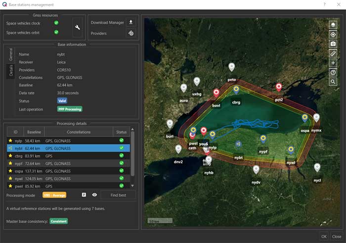
    The VBS computes a virtual network around a project in which position accuracy is maximized, homogeneous and robust like a PPK short baseline, SBG said. Once surveyors collect data, Qinertia chooses the most relevant reference stations, builds a virtual network and brings the project to the centimetric accuracy with no jump on accuracy nor convergence effects, even in urban areas.

    According to SBG, it has worked to offer a VBS which takes the most out of any GNSS receivers from different brands and models — with different configurations or constellations — and even with different coordinate systems. Qinertia automatically adjusts the VBS network to compensate for any base station position inaccuracy and provides full quality control indicators to assess the expected accuracy and reliability, the company added. Qinertia VBS technology can mix users base stations with permanent network base stations to improve accuracy in remote locations.

    Finally, Qinertia automatically selects the best positioning technology that applies to a user’s project, whether it is a single base station mode, the virtual base stations mode or a precise point positioning computation. Despite this, users can still take control and make adjustments — like — while Qinertia automatically re-checks and re-computes all parameters simultaneously to validate the accuracy and consistency.

  • SBG Systems supports education with inertial navigation technology

    SBG Systems supports education with inertial navigation technology

    The Ellipse-N INS/GNSS (Photo: SBG Systems)
    The Ellipse-N INS/GNSS (Photo: SBG Systems)

    SBG Systems has built a program designed to sponsor student teams participating in competitions, as well as offer discounts for universities and research centers on inertial sensors and post-processing software.

    Through the program, the company sponsors students participating in competitions in various fields, such as robotics, autonomous vehicles, UAV, rockets, unmanned and solar boats and more. This includes support during the competition, as well as during the installation of SBG’s latest inertial navigation systems in the teams’ vehicle prototype, the company said.

    SBG’s Ellipse series is also eligible through its education program. The series is composed of SBG’s miniature inertial measurement units, attitude and heading reference systems and inertial navigation systems. In addition, the entire product line has been renewed. The new Ellipse INS/GNSS embeds a quad constellation, dual frequency, and dual Antenna RTK GNSS receiver to bring centimetric position and higher accuracy orientation in the smallest package, SBG added.

    In addition to being compatible with CAN and ROS, the Ellipse Series’ sensors are compatible with SBG’s Qinertia Post-Processing Software, the SBG Systems’ in-house INS/GNSS post-processing software. Qinertia allows users to replay, analyze, improve their trajectories and access RTK corrections worldwide to bring their project to the centimetric accuracy.

    SBG Systems designs and manufactures MEMS-based inertial motion sensing solutions. According to SBG, its products are ideal solutions for industrial and research projects such as unmanned vehicle control, antenna tracking, camera stabilization and surveying applications.

  • SBG Systems offers GNSS+inertial navigation for surveying, UAVs

    SBG Systems offers GNSS+inertial navigation for surveying, UAVs

    SBG Systems is launching the Navsight Land & Air Solution, high-performance inertial navigation designed to make surveyors’ mobile data collection easier, whether for mobile mapping, GIS or road inspection.

    SBG Systems will release the Navsight Land & Air Solution at the Intergeo show in Frankfurt, Germany, Oct. 16-18.

    The solution consists of an inertial measurement unit (IMU), available at two different performance levels, connected to Navsight, a rugged processing unit embedding fusion intelligence and a GNSS receiver. It also has connections for external equipment such as lidar, cameras or computer.

    Photo: SBG Systems
    Photo: SBG Systems

    The Navsight Land & Air Solution is the result of more than 10 years of experience in the mobile positioning industry, especially in the unmanned industry where position reliability is mandatory. SBG’s fusion algorithms allow the company to get the best performance from inertial, odometer and GNSS technologies; exclude false GNSS fixes; and improve the trajectory in complicated areas such as urban canyons, forests and tunnels.

    According to the company, the Navsight Land & Air Solution supports all GNSS constellations, real-time kinematic (RTK) and precise point positioning services such as Omnistar and TerraStar.

    SBG IMUs are easy to install, the company said. The sensor alignment and lever arms are automatically estimated and validated. Once connected to the Navsight processing unit, the web interface guides the user to configure the solution. A 3D view of the vehicle shows the entered parameters so that the user can check the installation. By choosing the vehicle, such as a plane or a car, the inner algorithms are automatically adjusted to the application. The Navsight unit also integrates LED indicators for satellite availability, RTK corrections and power.

    INS/GNSS Post-Processing Software. Qinertia, the SBG post-processing software, provides access to offline RTK corrections from more than 7,000 base stations in 164 countries. Trajectory and orientation are greatly improved by processing inertial data and raw GNSS observables in forward and backward directions.


  • Viametris mobile backpack scanner includes panoramic camera

    Mobile-scanning company Viametris has launched the bMS3D backpack mobile scanning system, which features an embedded 360° camera.

    Narrow streets and pedestrian zones are considered hurdles when it comes to mobile scanning. The new bMS3D-360 makes these tasks achievable. It is now available on the market and it comes with post-processing software. It will be presented at SPAR 3D 2018 in June.

    “Users of mobile scanning systems know how difficult it is to cover an entire city with this kind of system and how complex the completeness is,” said Jerome Ninot, founder of Viametris.

    Improved Data Exploitation with Panoramic Images. Viametris has found a solution to scanning challenges by developing the bMS3D-360: the mobile scanning backpack system includes a panoramic camera. This sensor allows the user to maintain continuity of results with mobile mapping systems on cars that already include this kind of camera. Operation and visualization with such 360° images are now easy to use.

    Since Google provided massive street views, people are used to navigating through panoramic images. Navigating through bMS3D-360 images becomes easy and intuitive compared to navigating with 3D point clouds, the company said.

    Ten years of experience have allowed Viametris to produce its GNSS mono-antenna system based on GNSS-free scanning (indoor or denied-GNSS area): the system trajectory is calculated by lidar-SLAM. It produces colorized point clouds with absolute accuracy of less than 5 centimeters under appropriate satellite reception conditions.

    Compared to many mobile scanners, this backpack does not rely on GNSS to work. If the GNSS reception is not good enough, control points can be added for absolute localization. The backpack can be used to scan all sorts of indoor areas such as airports, industrial buildings or shopping malls.

    The bMS3D-360 is lightweight. It protects the retractable camera an all other components since it is self-contained.

    Post process in VIAMETRIS PPiMMS Software. PPiMMS post-processing software manages the dataset coming from the system. Its mission is to calculate, control and improve the trajectories by calling lidar-SLAM functions, and reducing drifts, thanks to loop closure algorithms.

    The user can manually add GCPs to constrain the result when GNSS reception is poor. But, in most cases, the user will be able to include post-processed global positions (PPK) using GNSS post-processing software. Additionally, the panoramic camera can be used to colorize the point cloud using PPiMMS.

  • SBG Systems unveils Qinertia INS/GNSS post-processing software

    Qinertia, SBG Systems’ new in-house post-processing software, gives access to offline real-time kinematic (RTK) corrections, and processes inertial and GNSS raw data to further enhance accuracy and secure a survey.

    SBG Systems will unveil new software for the surveying industry at the Ocean Business show, held in Southamptom, United Kingdom, April 4-6.

    For more than 10 years, SBG Systems has been designing inertial navigation systems from the internal inertial measurement unit (IMU) to filtering with GNSS data. Expert in real-time data fusion, the company takes another step in the surveying industry by unveiling Qinertia, a fully in-house post-processing kinematic (PPK) software. Whether the survey is made from a car, a UAV, a plane or a vessel, Qinertia will secure and enhance the acquisition.

    Virtual Base Station

    After the mission, Qinertia gives access to offline RTK corrections from more than 7,000 base stations in 164 countries. By creating a virtual base station near your project, the software delivers the highest level of accuracy without having to set up a base station, the company said.

    Trajectory and orientation are then greatly improved by processing inertial data and raw GNSS observables in forward and backward directions. Qinertia also secures the survey by fixing afterwards lever arms or sensor misalignment.

    Qinertia has been designed to help surveyors get the most of their surveys with simplicity. Surveyors can begin a project with a step-by step wizard, access an always up-to-date reference station database, and consult advanced quality indicators. With 64 bits and a multi-core design, Qinertia is fast processing software.

    Qinertia will be available in the fourth quarter of this year. A public beta test program will begin early this summer.