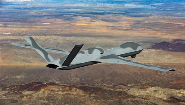
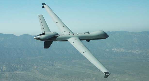
One of the top dogs in the mil-spec UAV world, General Atomics Aeronautical Systems Inc. (GA-ASI) has developed and built several jet-powered demonstration UAVs known as the MQ-20 Avenger, which is currently being used to test out new U.S. Navy communications systems. Derived from the MQ-1 Predator and MQ-9 Reaper, the Avenger is equipped with a Pratt & Whitney turbofan jet engine, allowing it to reach speeds of around 400 Knots at an altitude of up to 50,000 ft.
Predator C Avenger UAV. (Photo: GA-ASI)
After extensive testing since its first flight in April 2009, a larger extended range (ER) version began test flights in 2016. The extended range version has longer wings and an increased fuel capacity with a range of 2,000 miles and an endurance of 20 hours. Avenger has several stealth features, including an S-shaped engine exhaust and an internal weapons bay for precision weapons and sensor packages, similar to the F-22 Raptor and F-35 Lightning front-line fighters. Another recent project saw F-35 technologies passed onto the same jet-powered UAV platform.
The recent Navy communications trials were used to prove the new space-based comms capability and to remotely adjust Avenger’s autonomous internal navigation system while in flight. The aircraft has been designed for long-range, high altitude, speedy, autonomous penetration of enemy areas and this latest capability allows operations where the run-in-to-target phase can be redirected in the very last minutes of an attack. Enemy radar tracking and defenses might, therefore, be misaligned at a crucial phase of an incoming drone alarm without sufficient time to re-align and protect the actual target.
Space-based communications, in this case, used signals via the Proliferated low-Earth orbit (LEO) system of satellites, which is reportedly a mil-spec LEO constellation of communications. satellites — somewhat related to the orbits of the Space-X commercial Starlink LEO internet satellite system.
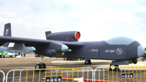
While we are in the military domain, a recently displayed Chinese development is being claimed to be a jet-powered ‘mothership’ UAV. The concept is that the carrier aircraft travels longer distances and releases a swarm of short-range drones when within range of their target(s) — a possible mock-up of such a vehicle was shown before a recent Chinese airshow.
Jiu Tian mothership UAV mock-up. (Photo: Chinese internet)
The center section of the UAV appears to be detachable or has large opening doors – the Chinese and English inscriptions on it imply that it is a module for carrying drones. There have been other reports that Chinese military thinking includes the deployment of large swarms of drones to attack multiple targets simultaneously. However, The Jiu Tian UAV does not come with a stealthy design.
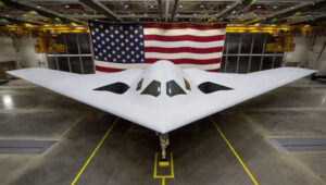
In light of the recent competition between the U.S. and China, an article about the new U.S. Air Force B-21 stealth bomber has been published. The article suggests that, given the F-35 stealth fighter-bomber’s exceptional stealth capabilities and its ability to carry and release multiple weapons from an internal bay, the B-21 may already face obsolescence.
So then, why not re-purpose the B-21 to be a drone-carrying mothership that could, while undetected, penetrate enemy defenses to release swarms of U.S. attack drones?
B-21 next generation Stealth bomber. (Photo: U.S. Air Force)
Currently, a part of the U.S. three-pronged nuclear delivery deterrents alongside submarines and ballistic missiles, the Air Force believes that the role of the existing B-2 Spirit bomber is not obsolete, and the B-21 should become operational as planned in the 2030s with its new stealth and suite of high-end technology sensors and control systems.
The concept of a Chinese “mothership” is designed to transport drone swarms close to targets before launching them. Additionally, there may be a stealthy response from the US, utilizing low-Earth orbit (LEO) satellites for space-based communications to adjust the routing of autonomous drones. This approach raises the question of whether it could be used to deceive drone defenses during the terminal phase of an attack. These solutions are complex but could significantly enhance the effectiveness of future military drone operations.
General Atomics MQ-9 Predator. (Photo: General Atomics)
There has been a lot of scene stealing by General Atomics recently with Predators flying hither and thither, new orders for the Boeing-Navy unmanned re-fueling drones and a UAV flying on Mars — this month’s unmanned aircraft summaries.
The Predator is the archetypical unmanned aircraft which most people might visualize as a “drone” as a result of numerous news reports and photos. Its what we might refer to a “Large UAV” with a 65-ft. wingspan, a 35 ft.-long fuselage and weighing in at around ~10,500 pounds fully fueled.
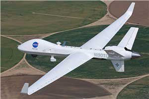
The SkyGuardian. (Photo: General Atomics)
In fact it’s bigger than a small manned aircraft, like the single engine Cessna 182 which checks in at 36ft wingspan/29ft fuselage. So its clear that something this big and without an on-board driver has to watch where its going, especially when flying within in the US National Airspace System (NAS).
So it was no small feat when General Atomics recently flew a new MQ-9 Predator on a delivery flight from its flight ops center in Palmdale, California, to the Holloman Air Force Base in New Mexico. There was significant coordination by the flight teams in both locations, and with the approval by the FAA. Delivering a new Predator by air saves the Air Force significant manpower, as normally new ones arrive in a crate and require effort to re-assemble.
It’s a sign of progress towards achieving approval to allow regular flights of such large UAVs in the NAS. Nowadays a Cessna 182 pilot can file a flight plan and then basically fly anywhere in unrestricted airspace. Hopefully one day — as a consequence of following rigorous certification verification and FAA approval – pilots of such Large UAS will be authorized to operate in a similar fashion.
General Atomics is working with the U.K. Royal Air Force (RAF) to develop and certify the all-weather, long-endurance SkyGuardian MQ-9B variant to meet NATO-standard Type-Certification requirements, which will then enable the UAV to be flown in civil airspace. The Australian Defence Force (ADF) has also selected this UAV variant for its unmanned applications in and around Australia. In late March, General Atomics flew the first production representative SkyGuardian – known to the RAF as the ‘Protector’ – out of its flight ops facility in El Mirage, California.
Staying with the military theme, Boeing has been working with the US Navy to develop a UAV that can land on aircraft carriers, and following a concept change by the Navy, won a contract to provide tanker UAVs. Tanker UAVs will fill up with aircraft gas on an aircraft carrier or land base, then take off and fly to rendezvous with fighter aircraft to transfer fuel and extend fighter endurance and range.
Right now tanker aircraft are usually quite large aircraft – like the Boeing KC-46A tanker which is based on the Boeing B-767 civil transport aircraft which many of you may have flown on as passengers.
The MQ-25 is still in its initial phases, with four test UAVs slated to undertake the initial flight test program. The first test vehicle has already begun exploring the UAV flight envelope and has 30 flight-test hours under its belt. The Navy has just shown confidence in the program by ordering another three aircraft, bringing the total initial build to seven vehicles.
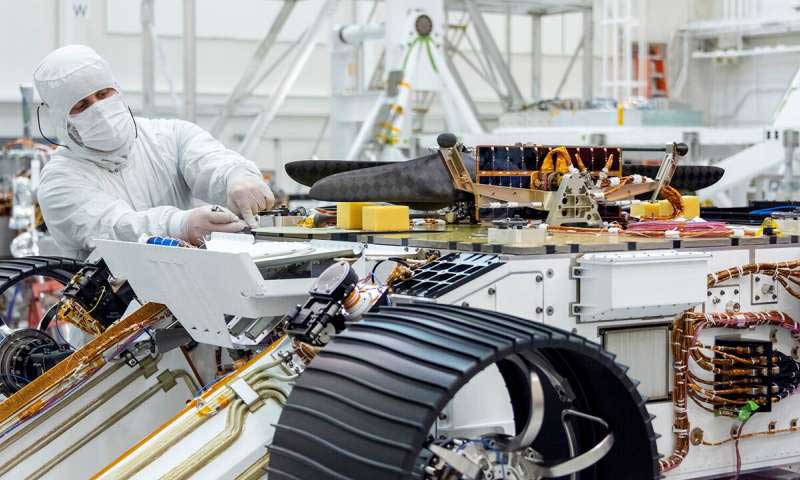
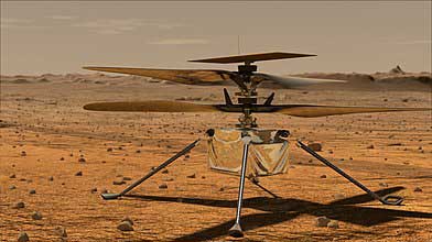
Its easy to see that UAVs are showing themselves to be extremely useful to military forces, but it might be difficult to understand how a UAV might find itself in the U.S. space program. The “Mars Helicopter” has just been mated to the underside of the next Mars Rover — now called “Perseverance” — both are slated to leave on their eight month journey to Mars in July this year.
Mars UAV being mater with Perseverance. (Photo: NASA)
With two ~4ft rotors which spin in opposite directions, the UAV will have to wait patiently for up to 90 Martian Days after Perseverance touches down in February 2021 until it gets a chance to prove that it can fly in the thin Mars atmosphere — chamber tests here on Earth in simulated Mars air have already shown that flight should be feasible.
Built to withstand high g launch and vibration forces and those of the Mars landing, the UAV carries a high resolution camera which is used for navigation, landing and survey of Mars’ surface. Its also designed to withstand the extreme temperatures and high radiation environment on the surface of Mars. The UAV is equipped with a dual-processor flight controller linked to sensors which include a gyroscope, an altimeter, visual odometer, hazard detectors and a ‘visual inertial nav system’ developed by JPL. Although the Mars Helicopter operates autonomously, it communicates with and receives control inputs from the lander, so controllers on Earth load up the flight plan ahead of time into the lander, and then wait for the helicopter UAV to execute the commands. Don’t expect vast coverage of huge panoramas of Mars – its flights are each intended to be more of an extensive hop lasting around 90 seconds at 10-15 ft above the terrain.
Mars Helicopter on simulated Mars surface. (Photo: NASA)
With a body no larger than a softball and weighing less than 4 pounds, the Mars Helicopter is an experiment to see if its possible to fly in the extremely thin Martian atmosphere. With less than 1% the density of our sea-level atmosphere, its necessary to spin the rotors at 2,800 rpm, ten times faster than on Earth. The UAV collects power from its own small solar panel and needs several days to recharge after each flight — of which five are planned. The main objective if flight is possible is to pre-survey interesting potential routes for the lander.
So preparations for large UAVs to regularly fly in civilian airspace, a new approach for Navy refueling systems, and a helicopter UAV destined to fly on Mars next year — completely different unmanned applications, all making progress.
From growing crops to making movies, unmanned aerial vehicles (UAVs) are changing the way we work. UAVs — managed by unmanned aerial systems, or UAS — range from small indoor inspection units to giant Predator drones. They are streamlining how we manage mines and plants, deliver packages, and keep people safe. Read on to find out the latest in this skyrocketing market.
The unmanned aerial system (UAS) industry is in great shape! In the United States., the Federal Aviation Administration (FAA) appears to be helping commercial operations get off the ground, at least for those wishing to fly small unmanned aerial vehicles (UAVs).
Things are certainly hopping for unmanned aircraft in agriculture, mining and construction, facility inspection, newsgathering, movies and promotion. Package delivery is on the way, and, of course, defense is cooking with new innovations. Everywhere you look, a specialized drone or new application seems to appear that has good prospects for success.
One helpful aspect of today’s landscape for UAS operators in the U.S. is the FAA’s supportive approach to small UAS (sUAS) for commercial activities. After providing a regulatory framework with Part 107 rules, albeit with quite a few caveats that require a written waiver application, qualified drone operators are now able to fly their drones in many places — as long as they are below 400 feet, well away from airports, and nowhere near any restricted airspace.
Pilot qualification courses and proficiency testing are both readily available — at 676 commercial facilities across the U.S. according to the FAA website — and a successful online application process should result in a remote pilot’s certificate.
With a drone registered with the FAA, you can use the FAA’s B4UFLY mobile app to check if it’s safe to operate where you intend to. If it is, you can get approval in real time using the FAA’s Low Altitude Authorization and Notification Capability (LAANC) system. The FAA qualified LAANC to clear commercial drone operations, and the service is now provided by a large number of independent UAS service providers.
With the regulatory and approval path in place, it’s now possible for companies and individuals to earn a living with turn-key drone operations, providing services for many applications that have blossomed. There’s work to do beforehand, but it’s less arduous than for manned flight operations.
Let’s look at a few of the applications benefiting from the automation, enhancement and remote operations provided by UAVs as well as their on-board sensor suites and after-flight processing:
agriculture
mining and construction
facility inspection
newsgathering, movies and promotion
package delivery
defense
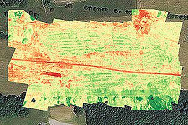
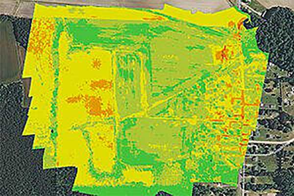
Crop health analysis: Precisionhawk’s software PrecisionAnalytics—Agriculture automatically generates georeferenced orthomosaics from data collected with drone sensors. (Map: PrecisionHawk)
Agriculture
Agriculture has readily adopted UAVs to monitor, control and improve overall crop growth rates — a part of what is known as precision agriculture. Drones carrying optical, thermal and laser scanning payloads gather stacks of information about the condition and rates of growth in fields. The information is then fed into various analysis tools. A picture emerges over time that indicates the health of crops. This enables farmers to generate a formulas for the nutrient and weed-reduction chemicals used for spraying at various times of the year. It’s a customized “prescription” for each growing area.
Continuing UAV overflights during the growing cycle monitor the effects of growing conditions and the effectiveness of treatments, providing more feedback that lead to even further improvements.
Smaller tech-savvy farms might run their own programs, supported by local agrochemical suppliers that may provide analysis services or sell analysis tools.
However, there has been a real growth in the number of companies that supply an entire turn-key package — supplying and flying drones, gathering data, running analyses and providing written and graphic output to support the farming operation.
Unmanned aircraft are truly an integral part of this approach, which might only have been possible because of semi-autonomous UAS and the evolution of compact sensors: UAV-mounted infrared, high-precision optical and lidar.
A sample prescription map. (Map: PrecisionHawk)
Mining and Construction
Any mine site is a busy — even chaotic — place to conduct a commercial business.
Drones provide a way for mining operations to:
quickly collect information to enable volume calculations;
provide relatively inexpensive site surveys; and
manage traffic and set up daily road layouts.
In effect, drones enable more rapid control of a complex and dynamic undertaking. Additionally, they improve safety. Ground surveyors no longer need to dodge huge operating machines and tumbling ore, or scramble around difficult terrain.
An autonomous drone can gather timely, georeferenced imagery that can be turned into a precise 3D model of the site. Site managers can have immediate access to details of the UAV survey. They can see the extent of existing deposits and know where to support further mineral exploration, receive estimates of stockpiles and tailing volumes, ensure that personnel and equipment are in the correct locations, and compare aerial video and photography day by day to check progress and for record-keeping. Drones can carry a wide variety of imaging and sensor packages including visual, infrared, hyperspectral, lidar, sonar and radar.
It’s also quicker. For instance, using the senseFly eBee fixed-wing drone, a full aerial survey of an 88-hectare site took four to five hours, with about half of that time spent placing control points. To achieve the same level of detail, terrestrial surveying would take a single surveyor two to three weeks.
Construction Operations. The construction sector uses the same drone data-capture techniques for site details, off-line analysis and results tabulation to manage operations of complex work sites. Compared to mining, change can be more intensive during a construction project, so drone surveys might be repeated more often.
Surveying and GIS. Using drones is an industry unto itself, with high-precision RTK GNSS in the air and on the ground, and specialized analysis tools for high-accuracy applications. The speed of data gathering is the principal benefit to an industry that continues to be essential in many sectors. Lower precision GIS for asset tracking and the like could become a subset of the applications and tools already discussed.
Facility inspection. Outdoor and indoor facility inspection is definitely benefiting from the automation that suitably equipped drones and customized analysis tools can bring to both regular and infrequent inspection tasks. The number of regular complex refinery inspections can be significantly reduced. Inspections will no longer interfere with production and will improve safety for inspection staff. For instance, flame stacks that burn off excess gases can be prone to failure, so regular inspection is essential. Using a drone for the task is clearly much safer than using personnel.
An offshore oil and gas construction platform vents gases to relieve pressure. Flame stacks such as these require regular inspection. (Photo: Oil and Gas Photographer/Shutterstock.com)
BVLOS for Pipelines and Rail
Automated pipeline and railway track inspection have both become possible as drones are used over much greater distances, thanks to beyond visual line of sight (BVLOS) operational approvals by the FAA.
For BVLOS, users first need a validated sense-and-avoid technology on the drone. Also required is proven radio telemetry with uninterrupted command-and-control of the vehicle during flight, and an independent ground-monitoring system that confirms how the drone maneuvers throughout the flight.
In the case of a BVLOS flight this summer along the Trans-Alaska oil pipeline, a Perimeter UAV manufactured by Skyfront flew about 4 miles, maintaining a constant above-ground altitude of 400 feet with multiple ascents and descents of 1,000 feet on 45-degree slopes. The long-range hybrid multicopter drone was equipped with Iris Automation’s computer vision collision-avoidance system and was monitored by
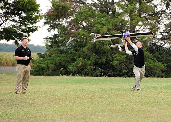
Launching a UAV for a BVLOS flight are (at left) Travis Balthazor, UAS flight operations manager, and Mike Kuni, UAS flight instructor/pilot, both of Kansas State University Polytechnic Campus. (Photo: KDOT, Division of Aviation)
Echodyne radars along the pipeline path, providing airspace situational awareness.
Another BVLOS operation built on the achievements of the Trans-Alaska pipeline trial has been authorized to fly a nine-mile linear inspection of power lines in rural Kansas.
Once again, the Iris Automation system will provide collision avoidance, but this drone also has an independent automated avoidance capability. This gives the drone the self-contained ability to fly around obstacles, so no ground radar or visual tracking is required.
Relieving the requirement for radar tracking or visual observers makes many new operations affordable. Previously, FAA Part 107 BVLOS waivers have all required visual observers or ground-based radar tracking — requirements that are not only expensive, but also restrict where flights are possible.
BVLOS operations like these demonstrate the cost-effectiveness of the technical solution, making long-duration, long-distance inspection using drones feasible.
Indoor inspection is becoming possible with specialized drones that circumvent the need to expose inspection staff to especially difficult facility environments, which in the past also required production shut-down to protect them. Thermal and visual sensors on swivel mounts enable protected inspection drones to fly into tight spaces — or even back out of tricky situations — and make visual records that may otherwise be virtually impossible.
Searching and recording inside containment vessels at the failed Fukushima nuclear facility may have been significantly advanced by using inspection drones.
Newsgathering, Movies and Promotion
All those panoramic, overhead, moving shots you see on the news, in movies and in ads used to be taken from a manned helicopter or fixed-wing aircraft. Now they are mostly taken by multi-copter drones with high-resolution cameras. This makes cinematography and newsgathering much more affordable, making these fields accessible by smaller operations. In the past, only large media groups could afford to rent a helicopter. And, of course, it’s much quicker to bring a UAV onto an incident site, operated by a crew on the ground.
You’ll need FAA approval to use a drone for commercial newsgathering purposes, or find a suitable qualified UAV and operator. After gaining FAA qualifications, news people are also taking on the job, buying and flying the equipment and managing the video-processing software themselves.
Others using drones for similar purposes are movie makers, producers of TV commercials and real estate agents, to name a few.
Delivery by Drone
The ultimate objective of many internet suppliers is to deliver goods that were just ordered within minutes of the order being placed. This is a pretty big objective. It requires a whole network of “fulfillment centers” in and around many cities, a massive purchasing and goods movement capability to keep these centers stocked, and a system that delivers to the end-customer. Currently, we mostly have manned panel trucks of various flavors handling that last step of the delivery process, with real people reading the notes we put on the porch about where to leave our package if we’re out.
Order and Receive. The next wave of delivery changes are expected to include drones carrying your package from the fulfillment center to your backyard. Amazon is looking for approval to begin trials with its larger 88-pound MK-27 Prime Air delivery drone, initially in sparsely populated areas. The MK-27 is equipped with intelligent sense-and-avoid capability, flying around any obstacles it encounters in flight and even during delivery.
UPS is also hoping to get to qualification of its own UAS delivery system by the end of this year, to the same standards that manned aircraft delivery systems are certificated.
Medical Deliveries. Many other trials are underway, especially involving medical deliveries and support. In Africa, trials are underway in Ghana, Malawi and Rwanda. UPS recently proposed a medical supplies delivery service using drones in North Carolina. Many companies that claim expertise in medical deliveries are operating drones.
Food on the Fly. Restaurant food delivery services have seen an upsurge in popularity. It seems likely that soon you’ll be able to order and receive lunch really quickly by drone food delivery services. Ground robot food deliveries at George Mason University are already a huge hit! Uber-Eats is experimenting with drone food deliveries, and 17 drone delivery routes have already been approved in an industrial park in Shanghai.
Meanwhile, Bell has flown its autonomous pod transport (APT) 70 near its base in Fort Worth, Texas, for the first time. The APT 70 can carry a 70-pound package load at over 100 mph, far faster and farther than existing drone delivery systems.
Bell is aiming for package delivery and critical medical transport for disaster relief for APT type drones. It is also participating in the NASA SOI program along with General Atomics’ SkyGuardian.
Drones are a new tool. The UAS industry will continue to change and adapt these products and this technology in as-yet-unthought-of ways. It’s an exciting time, and right now, there seems to be no end in sight.
For a look at drones in the defense industry, see Murfin’s article “Defense in front of UAV development,” published in September’s Professional OEM + UAV newsletter.
Some ups and downs for unmanned aircraft this month — good news that there is further progress on the pseudo-satellite front, but we also have MIL-SPEC drones lost to shoot-downs and recent crash landings. Amazon continues to advance toward deliveries really soon after orders, and another police department takes up drone use for aerial observation.
High-Altitude Pseudo-Satellite UAS
HAPSMobile (Softbank 95% and AeroVironment 5% JV) is funding further development and testing of the Hawk30 family of high-altitude pseudo-satellite (HAPS) solar-powered unmanned aircraft, with the expectation of long-duration flights above 65,000 feet — “a super cell-tower up in the stratosphere…providing connectivity for everybody that needs it,” according to AeroVironment President and CEO Wahid Nawabi.
HAPSMobile is collaborating with the Pan-Pacific UAS Test Range Complex (PPUTRC), which is managed by the University of Alaska (UA) Fairbanks, and with the University of Hawaii (UH) to conduct stratospheric test flights using the HAWK30 prototype HAPS vehicle. On behalf of this group, UA was recently granted a Certificate of Authorization by the U.S. Federal Aviation Administration (FAA) to fly HAWK30 as a stratospheric telecommunications platform system over the Hawaiian island of Lanai.
The HAPSMobile team will prep test flights at Lanai during 2019, conducting safety verifications and working with island authorities to comply with local regulations. During the program, HAPSMobile will also explore contributions to environmental conservation and to agriculture. Hawaii — not a bad place to run test flights, you might say…
Predator UAV downed
Following the shooting down of a U.S. Global Hawk (really expensive) and one or two Iranian drones (not very expensive) in the Gulf of Hormuz, U.S. forces on Aug. 13 just crash-landed an MQ-1C Grey Eagle (Predator UAV family) southwest of Baghdad on farmland in the town of Radwaniyah. The following pictures were released by a local news group:
The aircraft doesn’t appear to be too badly damaged, and seems to have been deliberately brought to rest in soft undergrowth on the edge of a field. So crash-landing might be an overstatement — rather an unplanned landing, perhaps? Then again, the landing gear appears to be significantly bent out of shape, so the U.S. Army 52178 drone’s contact with the ground might have been heavier than normal.
The news source indicated that the drone might have been brought down by “electronic interference or have been intercepted by a cyber-attack.” perhaps references to potential jamming of some kind? Nevertheless, the aircraft landed safely and was then recovered by Iraqi Security Forces. There were no injuries or damage to property.
The U.S. Army MQ-1C Gray Eagle provides both combat and intelligence forces with a long-endurance, armed, unmanned aircraft system (UAS) with significant range, altitude and payload flexibility.
And another report hit the internet today that back in June, a £6 million U.K. Watchkeeper WK050 drone on a training flight met a somewhat messy end after overshooting its landing and coming to rest in a tree. But the report also mentions that there was some indication of possible operator error.
Amazon Drone Deliveries?
Fresh on the heels of Fed Ex deciding to dump Amazon as a customer because they would appear to be developing a competing delivery infrastructure, Amazon is proposing a semi-autonomous drone that could automate short-distance deliveries.
In a recent letter to the FAA, Amazon is proposing trials in “sparsely populated” regions of the U.S. using its latest 88lb MK-27 Prime Air delivery drone. The UAV apparently has well-developed sense-and-avoid for the flight phase and uses optical capability for the delivery phase.
If obstacles were to be detected in flight (other UAVs, low-flying manned aircraft, helicopters or birds) the MK-27 would avoid and fly round each obstacle. If an obstacle were detected during delivery (maybe the customer waving frantically to stay out of the cabbage patch) the delivery may be aborted and the drone would return to base. But would it automatically dispense one of those “We-called-while-you-were-out” postcards, fluttering down into the backyard so you could go pick up your package later?
Seriously, though… The initial trials would be managed by an operator who can command a return to base if the drone gets into any trouble, but Amazon claims that the fail-safe autonomy built into the MK-27 will make this unlikely. The hardware and software have gone through extensive simulated testing, and the drone has already completed more than 10,000 simulated delivery flights into representative backyards.
Amazon’s objective seems to be to eventually deliver packages within 30 minutes after the customer places an order — to Prime customers within ~8.5 miles from an Amazon fulfillment center.
Growing Police Use of Drones
The Oneida County, New York, Sheriff’s Office just announced that it is are now drone-trained and drone-equipped — with five certificated operators and a fleet of eight DJI Mavic drones for indoor and outdoor use.
The DJI drones will not be modified and will be used as is. The Mavic 2 drones will provide all manner of aerial surveillance including flood and disaster monitoring. In addition, active shooter investigations and the like could involve initial indoor surveillance using Mavic Air drone(s) to provide armed police with situational awareness before any take-down efforts. Accident investigations, location of missing persons, house fires, and rescue efforts are other applications for the drones.
The Sherriff’s department has been preparing for drone use for two years — five officers have already completed FAA-certified drone training, and others are expected to undertake training over time.
Summary
We have potential stratospheric “cell towers” being tested over Hawaii, landing accidents, preparations for potential rapid deliveries by Amazon drones, and another police department launching a drone unit. These are some of the expanding uses for drones, and the unfortunate reality that drones can sometimes get into operational difficulties.
General Atomics Aeronautical Systems Inc. (GA-ASI) has successfully flown the Predator B/MQ-9 Reaper Extended Range (ER) Long Wing craft.
The long-wing Predator is retrofitted with improved long-endurance wings, greater internal fuel capacity and additional hard points for carrying external stores. The flight took place Feb. 18 at GA-ASI’s Gray Butte Flight Test Facility in Palmdale, Calif., on a test aircraft.
GA-ASI is a a manufacturer of remotely piloted aircraft (RPA) systems, radars, and electro-optic and related mission systems solutions.
“Predator B ER’s new 79-foot wing span not only boosts the RPA’s endurance and range, but also serves as proof-of-concept for the next-generation Predator B aircraft that will be designed for Type-Certification and airspace integration,” said Linden Blue, CEO. “The wing was designed to conform to STANAG 4671 [NATO Airworthiness Standard for RPA systems], and includes lightning and bird strike protection, non-destructive testing and advanced composite and adhesive materials for extreme environments.”
During the flight, Predator B ER Long Wing demonstrated its ability to launch, climb to 7,500 feet (initial flight test altitude), complete basic airworthiness maneuvers, and land without incident. A subsequent test program will be conducted to verify full operational capability.
Developed on Internal Research and Development (IRAD) funds, the new wing span is 13 feet longer, increasing the aircraft’s endurance from 27 hours to more than 40 hours.
Additional improvements include short-field takeoff and landing performance and spoilers on the wings that enable precision automatic landings. The wings also have provisions for leading-edge de-ice and integrated low- and high-band RF antennas.
An earlier version of Predator B ER featuring two wing-mounted fuel tanks is currently operational with the U.S. Air Force as MQ-9 Reaper ER.
The long wings are the first components to be produced as part of GA-ASI’s Certifiable Predator B (CPB) development project, which will lead to a certifiable production aircraft in early 2018.
Further hardware and software upgrades planned for CPB will include improved structural fatigue and damage tolerance, more robust flight control software and enhancements allowing operations in adverse weather.