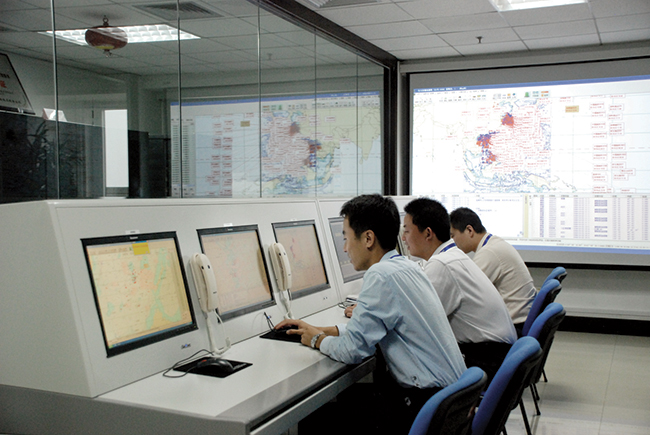
The world of indoor location continues to evolve, with a number of variations on when and under what circumstances you might be able to wander around your local mall getting directions to your favorite ice-cream store on your iPhone. Some malls are mapped, some are not, some (most) have Wi-Fi hot-spots and Bluetooth beacons, some may be in areas where outdoor directional beacon are being tested and their signals penetrate indoors. But the thing they have in common is that most seem to lose GPS/GNSS signals once you get a few tens of meters away from the front entrance.
Some companies have managed to make indoor location in your mall work with a combination of GPS, plus all the RF signals that can be received, plus using inertial and/or magnetic sensors in your mobile phone, and sometimes also with detailed indoor map-matching — but no-one seems to do this in a simple, consistent, reproducible way for any store wanting to ensure you arrive at their door, or for a telecommunication industry wishing to standardize how it works for E911 and then field it everywhere.
So I’ve actually been looking for an indoor location outfit who might have found a consistent solution that can work from place to place — by that I mean from mall to mall, city to city, country to country, even continent to continent, and every time after first set-up — and I suspect that I may have now found one.
The team at iPosi in Denver is still working on their solution, but they have run some pretty convincing demonstrations in some very challenging locations, so they may have found an inside edge that could take them many places (sorry, about that pun).
While iPosi’s headquarters are is in Denver, the company also has labs in Boulder and offices in Dallas. It hasn’t been around too long — since 2011 — but it has been busy filing patents for the key technologies that drive their location technology. Of 40 total patents in the pipeline, five have been granted or allowed, 15 are pending, and 20 more are in development. With only six employees, iPosi is a small outfit, but it also gets design assistance from a European design center for other GNSS signal designs.
One of the key GNSS elements the iPosi team has going for them is an in-house developed GPS receiver with a sensitivity of -175 dBm. If you could get any sort of a signal deep inside a building, it’s possible that they might be able to receive it. But, for sure, anything you would receive deep inside would be just multipath – right? There are other pieces to this story however.
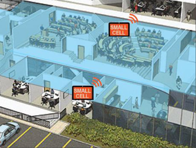
The iPosi system design is based on mobile phone “small-cell” installations. The world now has around 100 million multi-floor buildings with an average of eight floors each, and most buildings present some level of attenuation for external mobile phone cell-tower signals — never mind GPS signals. Most of us should be familiar with having to leave meetings to get “bars.” holding the phone up against a window, walking around to catch reflected indoor signals, and eventually having to leave the building and be with a group of other people who are doing the same thing – looking for a clear cell-phone signal to make a call. In the Northern U.S. and Canada in the winter, this can even be hazardous to your health!
So small cells behave as basically indoor “repeaters” of mobile phone signals. iPosi believes that an average of four of these repeaters are needed to broadcast sufficient signal on each average building floor. So iPosi embeds each small cell with one of its high-sensitivity receivers. Once positioned indoors, and over time, the receivers self-locate inside the building. Currently, installation of small cells can be somewhat cumbersome and time consuming, but non-GPS small cells can be located during installation using traditional indoor surveying techniques — such as laser-based measurements. Either that, or no measurements are made at all, and no device location information is associated with a device.
Small-cell setup.
With each small cell equipped with a high-sensitivity receiver — with especially clever algorithms to differentiate and interpret multipath over time — each device goes to work transmitting repeater mobile-phone signals and eventually self-locates. Contained within these signals are each small-cell location, plus a timing message that allows any standards-compliant handset to calculate range to each transmitter and to perform an OTDOA (Observed Time Difference Of Arrival) position fix.
If the small-cell location at install is also fed into the GIS database for the building and, more importantly, for the local area, the E911 “dispatchable address” for that building has GPS-level accuracy. And first responders will also have numerous other small-cell location aids within the building.
Another detail is that the iPosi receiver uses A-GNSS (including ephemeris) data, so it only needs small snapshots of signal to deduce position. This means very low power consumption for positioning at the small cell, which is good because small cells are mostly battery powered.
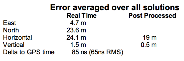
So, does it work? In FCC E911 demonstrations at the Omni Hotel in San Francisco, iPosi consistently located to within 50 meters horizontally and a few meters vertically.
Masonry, turn-of-20th-century construction
Approximately 15 floors, similar to surrounding
Test site: ninth floor hotel room
Horizontal error = 38 m, Vertical error = 9.5 m
There were several other tests in representative converted apartments, a modern four-story steel and concrete building, and inside a university auditorium. But the one that really caught my attention was the test iPosi ran in the basement of an engineering center.
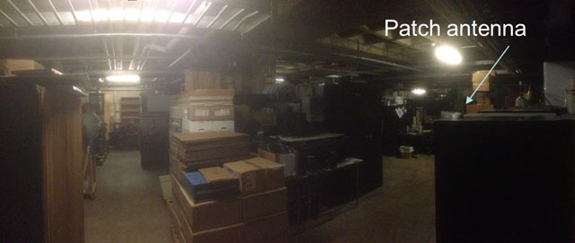
Engineering center, lower basement 3.5 m below grade.
That’s 3.5 meters below grade! The iPosi receiver measurement system was able to determine that some of the signals were actually received directly from a GPS satellite — unbelievable! That’s through concrete and stone down to 3.5 meters below grade with a simple patch antenna!
Most of your average mall locations are not as location-hazardous as this basement test. Its possible that finding your way to the closest indoor ice-cream store could soon be child’s play, which will be especially helpful for the kids with smartphones.
iPosi is working with some of the key equipment suppliers in the industry. It’s quite likely that some of its evaluation sites could soon evolve into operational indoor location facilities. And iPosi’s argument is that its indoor location solution is truly scalable or can be readily standardized — as the telecom companies apparently would love for all indoor location technology to be — so the iPosi solution can readily transition across borders and countries, and roll out could be greatly simplified.
Tony Murfin
Hard to say if this will be the winning indoor location solution, but in the end the market will decide if it really is a scalable, simple solution, and if it will succeed — right?
GPS World will host a webinar this Thursday, March 19, on the merits of using simulated jamming, spoofing and interference scenarios to prepare GNSS receivers for the brave new world of coping with adverse signal effects. It’s clear that users need to still operate commercially and individually, even when they get hit by extraneous interference — intended or otherwise — in a world where cigarette-lighter jammers, engineering “lash-up” spoofers, and badly designed commercial gear can ruin a person’s day.
Recently, I had a conversation with Guy Buesnel, market segment manager, GNSS Vulnerabilities, at Spirent Communications. He wanted to alert me to the concept that jamming and spoofing is at a stage where Internet hacking was many years ago. Hacking has progressed from the typical loan student in his bedsit or studio apartment pounding on a keyboard to break down banking or other institutional firewalls, to nowadays, where focused groups mount hacking attacks on targeted agencies or companies lasting days, weeks, even months. Huge effort is currently being applied to defending against these and future focused attacks.
Buesnel’s point is that organized attacks on GNSS may be coming, and coming soon. Individuals and groups are already self-jamming to prevent detection — organized car and truck thieves wanting to avoid location of stolen assets, or truck drivers wanting to prevent their employers knowing their whereabouts — using easily obtained “personal cigarette lighter” or even professional-looking jammers (see figure below). Jamming GPS L3 at 1381.05MHz might awaken U.S. Department of Defense (DOD) interest as it’s used by the Nuclear Detonation (NUDET) Detection System Payload (NDS), and L4 at 1379.913 MHz is currently only used for studies on additional ionospheric corrections.
But Buesnel warns that organized spoofing could soon start to happen, and happen frequently. And it could be argued that spoofing is more dangerous than jamming, because a user or someone monitoring a user might not know for some time that their position information has been compromised. Long enough, perhaps, for an unwary user to get into potentially serious trouble, especially in a higher speed, fuel-restricted application like an aircraft or a small boat running some distance offshore.
GNSS is already embedded into the critical infrastructure of utility providers, and also telecoms, financial and transport sectors for timing/synchronization or positional data, and the growth in vehicle automation will soon see GNSS being used for even more safety-critical applications. The security of GNSS is already of huge importance and a “GNSS hacking attack,” like those experienced by Internet users, could achieve significant disruption across a host of operational segments. Precise GNSS timing is already essential for time stamping some transactions and used extensively for cell-site synchronization, so significant damage could occur if timing information were to be compromised.
While an intentional spoofing attack has yet to be confirmed — except under conditions such as that drone spoofing demonstration and then the White Rose luxury yacht spoofing trials, both by University of Texas/Cockrell School of Engineering graduate students — unintentional spoofing has indeed been reported. GNSS repeaters radiating at higher power levels than actual GNSS signals can be the source of such spurious signals. The result can be that GNSS receivers may acquire and track the higher power repeater signals, and the receiver position becomes that of the repeater. Use of GPS repeaters in unsuitable locations, such as for production tests in an open workshop, have been reported. The risk is that GNSS signals could extend outside the building and affect users, so GPS receivers could be spoofed and tricked into reporting an incorrect position.
White Rose 213-foot luxury yacht. Photo: Tony Murfin
For more than 20 years, the information security community has debated publishing the methods used by hackers and others to expose and attack vulnerabilities within products. Initially, things were kept hidden and were only shared between groups of hackers or IT administrators. However, online hacker forums quickly distributed knowledge — often including sample code. This allowed everyone from security researchers and IT administrators to hackers to learn about the vulnerabilities of applications and critical systems. It would seem that both researchers and hackers alike have broken the spell, and now it’s easy to spread the word about backdoors and weaknesses in firewalls, critical applications and the like.
Fast forward, and we are now in the age of mass-market access to jammers of all kinds through offshore websites — even if it’s illegal to operate such devices. However, it’s also illegal to hack the Department of Defense, but that has not prevented hackers in the past from assaulting and penetrating all sorts of secure DoD computing facilities. So, let’s just assume that the individuals who get a kick out of creating mayhem may eventually turn to something new — and the age of jamming and spoofing for fun may be upon us.
All is not lost, however. Just as applications for finding and killing viruses have become more robust, and new “antidotes” and warnings are now automatically downloaded to your PC even as they are created, and huge amounts of effort are now being applied to creating the most robust firewalls, so the designers of GNSS receivers are working hard to immunize their systems against anticipated attacks. And simulator/replay manufacturers such as Spirent Communications, IFEN, Spectracom and Racelogic are developing and fielding ready-made spoofing and jamming capabilities and scenarios with which manufacturers can test and qualify their receivers — which you may well hear about during the coming GPS World webinar on March 19.
Nevertheless, some people in the industry are urging members of the GNSS community to act more cooperatively and report spoofing and jamming incidents/attacks for their own good. It seems that the industry only collaborates in the face of a major common threat — take the ultra wideband and LightSquared episodes where the response was virtually unanimous. While most GNSS manufacturers in the meantime tend to maintain a very proprietary cover to their field experience and technological solutions, this still leaves customers exposed to product vulnerabilities. The GNSS community now has the advantage that the information security community has been working through these hurdles for the past two decades. Lessons learned include the following:
Controlled, responsible disclosure and cooperation allows everyone to monitor the threat and how it is being dealt with.
Without restricted disclosure and preventive solutions, attacks will always take advantage of weaknesses.
Eventually, disclosure of product vulnerabilities will result in more respect and confidence in manufacturers by users.
Rapid resolution of issues is essential.
The GNSS community has an opportunity to come together, learn from the information security community, and adopt best practices to secure and protect its customers.
(With grateful thanks to Guy Buesnel and David DeSanto of Spirent Communications!)
Editor’s Note: Tony Murfin is managing consultant for GNSS Aerospace LLC and editor of GPS World’s monthly Professional OEM newsletter. The views expressed are his own.
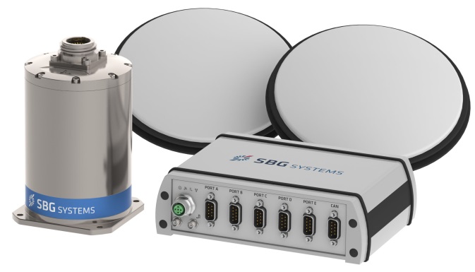
Another year has gone by, with another year of further improvements in navigation performance of micro-electro-mechnical systems (MEMS) inertial products. SBG Systems in France is now fielding a new generation of MEMS inertial products for much higher accuracy applications.
SBG Systems is based in Rueil-Malmaison, less than eight miles west of the center of Paris. Founded in 2007, SBG has developed a number of innovative MEMS inertial products over the last seven years, along with a respected reputation in the navigation industry, and by 2014 the company was recognized as the 26th fastest growing company in France.
The roots of the company began to form at the end of 2004, when a group of ECE School of Engineering students in Paris put a team together for a new UAV competition. The goal was to build a UAV of less than 1 kg, capable of flying autonomously indoors — at the time, a significant technical challenge. In 2004, miniature INS was not commercially available, so the team decided to build one, as well as other electronic parts such as the autopilot. The competition ran out of money, but the design was a success and led to a working UAV. The INS was by far the most advanced part of the project.
The students went back to their studies and took internships at UAV companies and ONERA (French aeronautics, space and defense research labs), but they still believed in the need for low-cost navigation solutions for the emerging civilian UAV market.
So, in 2007, three of the students — Raphaël Siryani, Thibault Bonnevie and Alexis Guinamard, S, B and G — formed SBG Systems with the goal of providing affordable, highly accurate MEMS inertial navigation systems for UAVs.
SBG quickly received its first Innovation Award from the French Research Ministry, and with this funding launched the IG-500 series of MEMS AHRS and INS in December 2008.
The company has since grown into a worldwide player with a strong product innovation focus. UAVs are still an important part of revenue, but the company has diversified into:
Aerospace and defense applications (UAVs, gimbaled cameras, antenna tracking, etc.)
Marine and offshore activities (ROV/AUVs, buoys, etc.)
Survey (hydrography, mobile mapping, aerial LiDAR, etc.)
SBG Systems has a small staff of mostly development and sales engineers — graduate students and experts. SBG has recruited navigation experts and some sales people from key players in the inertial business. Most (95%) have at least a master’s degree in engineering — R&D has 45% of the staff, and 40% are in sales, marketing and technical support. Production has been extremely automated and requires very few staff for in-house system assembly, calibration and final acceptance test. They do expect to double in size over the next two to three years.
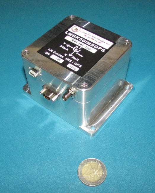
The company is owned by the three founders, who still lead operations. SBG grew 1,304% over the last five years, and last year was ranked the 26th fastest growing company in France on the Deloitte Fast50. Today, SBG Systems has fielded more than 4,000 attitude and heading reference systems (AHRS) and INS (mostly INS), with almost a third of those delivered last year. The company forecasts growth for the next five years to be at this same phenomenal rate! SBG Systems currently offers a line of MEMS inertial sensors that include AHRS, inertial measurement units (IMU), and INS with embedded GPS (INS/GPS).
Ellipse-D dual-antenna mini INS/GNSS.
Not only have MEMS sensors improved in performance, but SBG has also developed advanced calibration capabilities that allow it to reach high-precision performance approaching high-end ring laser gyro accuracies in much smaller, less expensive packages. SBG owns an extensive set of temperature chambers combined with rotary tables and vibrating tables. Each SBG system gets to stay two to five days inside these calibration tools. But the “secret sauce” is in a state-of-the-art SBG developed calibration algorithm…
SBG buys MEMS gyros and accelerometers from MEMS manufacturers such as Colibrys, Analogue Devices and Silicon Sensing and builds complete inertial systems. The team embeds different GNSS receivers, depending on the product line and intended application — from miniature automotive-grade chipsets from u-blox to the very best from the key survey-grade players such as Septentrio, NovAtel and Trimble. Some customers may already have their own GNSS receiver, so SBG has developed and tuned their systems to work with any of these big manufacturers. The antenna employed depends on the receiver being used — from Tallysman Wireless and Antcom to Trimble, Septentrio or NovAtel — a very diversified range of antennas.
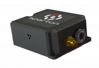
Ellipse-E.
SBG announced the Ellipse-D dual-antenna mini INS/GNSS earlier this month. The Ellipse-D is a miniature INS with an embedded dual-antenna survey-grade GNSS receiver for high-accuracy orientation and positioning.
Independent hydrographic testing in October 2014 of earlier model designs has already shown accuracy improvements, and the latest D version promises even better performance. The products tested were:
Ekinox-D
Ellipse-E, miniature inertial navigation system connected to a Hemisphere VS330 GNSS with two antennas.
Ekinox-D, inertial navigation system integrating a dual-frequency GNSS receiver with two antennas.
The test was a typical marine survey, with each leg about 550 meters long. Attitude performance was compared to a fiber-optic gyro compass reference system with much higher roll and pitch accuracy than the two SBG products under test.
Ellipse-E roll and pitch accuracy is better than the specs. The use of an RTK GNSS receiver additionally improves the sensor’s performance. The Ekinox-D also has good results — around 0.03° in both roll and pitch. SBG claims that low-noise gyroscopes and advanced algorithms are the basis for this performance.
The SBG list of 250 customers in 30 countries includes some impressive names, many outside Europe, and the company claims to have nearly 4,000 inertial sensors in the field. So this is not a prototype shop, but more a fully equipped production facility. SBG has opened an office in Chicago to address the North American market.
So, what are people doing with these devices? There are a number of applications in aerospace, land, marine and sub-sea.
In the aerospace industry, SBG sensors are used for UAV navigation and flight analysis — they could eventually be incorporated in certified avionics. They are also used for antenna tracking, camera stabilization and more demanding applications such as LiDAR orientation and data georeferencing.
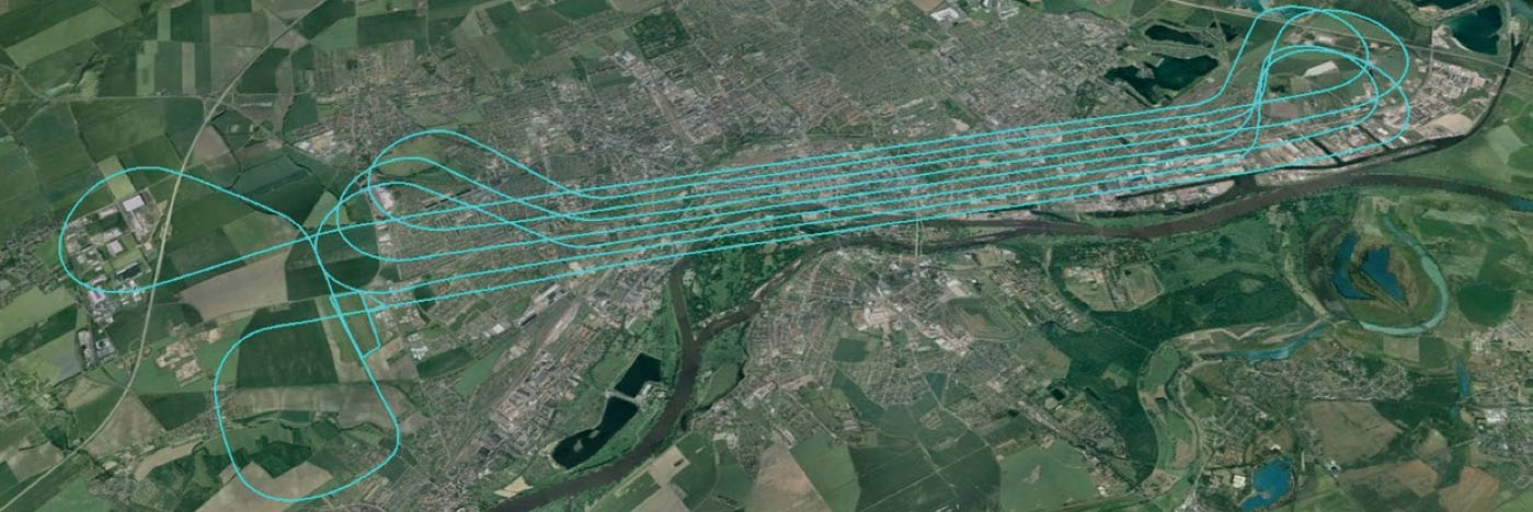
An Ekinox-N INS with embedded GNSS receiver was installed for the tests in a single-engine general aviation aircraft flying out of Magdeburg, Germany. A typical airborne survey-type flight was flown under mixed weather conditions with some turbulence, and roll, pitch, and altitude data was collected for real-time analysis and was also post-processed. A high-grade FOG-based AHRS was used as reference unit — with very high accuracy gyroscopes.
The flight pattern was typical of survey applications, with parallel straight lines of about 8.5 km. Altitude was 600 m and cruise speed was about 200 km/h.
Roll
Pitch
RMS Error Real Time (max)
0.043° (0.16)
0.043° (0.16)
RMS Error Post Processing (max)
0.017° (0.19)
0.025° (0.20)
Real-time accuracy remained below 0.05° RMS for roll and pitch. Post-processed output had a lower RMS error and a better stability over the whole flight. Only one GPS antenna was used in this test with Ekinox-N; nevertheless, heading reached an estimated accuracy of 0.06° when post-processed. The Ekinox-D model provides more accurate heading thanks to its integrated dual-antenna and GNSS receiver.
The Ekinox-N has been integrated on a UAV by Headwall in the U.S. for remote-sensing applications.
Headwall is a leading designer and manufacturer of high-performance hyperspectral imaging sensors for harsh environments. As a pioneer for remote-sensing applications, Headwall is the first to market a fully integrated remote-sensing solution combining hyperspectral and LiDAR sensors on a small UAV. This “total solution” approach has been welcomed by the remote-sensing market because it quickens time to deployment, decreases implementation costs, and enables operations in harsh environments.
The multi-rotor UAV carries Headwall’s lightweight Micro-Hyperspec VNIR hyperspectral sensor and a Velodyne LiDAR unit. The LiDAR collects a point cloud that reflects the field’s topographic relief, and the hyperspectral sensor delivers a picture showing spectral signatures of every object within the field of view. The SBG inertial navigation system has an embedded GPS and is used to provide positioning and orientation data. Weight is a key factor — Ekinox-N weighs only 500 grams, even though it integrates a survey-grade L1/L2 GNSS sensor to provide accurate positioning and precision roll, pitch, and heading data.
Mounted on the UAV, the Ekinox-N provides LiDAR and the hyperspectral camera with orientation and position during the whole flight. This and other data is recorded in real time at 200 Hz within the onboard computer. On the ground, the Headwall post-processing Hyperspec software fuses all sensor information. Ekinox-N data allows every scanned point and every pixel to be georeferenced and be tilt compensated to within a centimeter.
SLAM-based Indoor Mapping System by VIAmetris.
For miniature inertial sensors, smaller and lighter applications are possible at less cost. One of these applications includes the SLAM-based Indoor Mapping System by VIAmetris.
Simultaneous localization and mapping (SLAM) is becoming increasingly important to enable efficient indoor mapping. VIAmetris has created a different spin on indoor mapping with the “MID” portable SLAM-based scanner. This handheld system integrates a 2D LiDAR, a camera, an SBG Ellipse-A AHRS, and a tablet PC that shows the map being drawn while the user walks around inside the building. The AHRS also compensates for movement while orienting the generated maps to the north.
While the user walks, the 2D LiDAR scans in a horizontal plane by measuring 43,000 points per second across a 270° field of view. The SLAM technology progressively builds the map in the shape of lines made of points. At the office, the surveyor imports the data into the post-processing software and uses the lines of points to design the map. If there is any doubt about a specific shape — whether it is actually wall or furniture, for example — a photo of the location is available as MID automatically takes contextual pictures every meter, or whenever there is a change of direction, or manually.
The centimeter-level accurate map is then ready to be imported into most CAD software. As the system works without GPS, the generated map is not georeferenced or in a local coordinate reference system. To do so, the user links MID’s points cloud to a known point and all data is automatically referenced. MID is much easier to use than a laser distance meter, a tachometer, or a 3D scanner, and significantly reduces the time required for indoor mapping.
SBG is now working more often in the marine industry, equipping boat, cranes, or instrumented buoys. The company has even developed a specific solution for the hydrographic market. The SBG Ekinox Hydrography Solution integrates Ekinox-U which operates to a depth of 200 meters, and incorporates a SplitBox with a built-in tri-band RTK GNSS receiver and uses Terrastar, OmniSTAR, or Marinestar corrections.
The SBG Ekinox Hydrography Solution.
For subsea operations, positioning is required for ROVs and AUVs that navigate for minutes or sometimes for hours underwater. GPS fixes are only available when the vehicle comes close to the surface. But operators usually try to expend the time they are able to operate close to the seabed. To avoid typical INS drift, different aiding sources are used — the three main ones are acoustic positioning, Doppler velocity loggers (DVLs) and depth sensors.
Acoustic position is far more noisy and unstable than GPS.
DVL is a kind of 2D odometer, providing speed over the seabed.
The INS and the Kalman filter therefore play a key role to provide reference heading and reliable position data.
It’s a major concern when you have a massive ROV working on pipes under an offshore platform. Any mistake can cause severe damage and cost millions.
So SBG is moving along and taking on new, challenging applications with a range of MEMS inertial products that appear to be growing quite rapidly, with ever-improving performance. Once upon a time, we couldn’t stay anywhere within RTK-level performance during GPS outages because of the high drift-rate of MEMS inertial devices. Now, SBG has introduced its latest Ellipse-D dual-antenna mini INS/GNSS spec’ed at 0.1° real time for pitch and roll, with 2-cm RTK position.
The Apogee INS/GNSS.
And just today, SBG Systems has even bigger news with the release of the Apogee series, which is Apogee’s most accurate, robust and cost-effective MEMS technology inertial navigation system. The Apogee INS/GNSS integrates the very latest generation of MEMS sensors along with a triple-frequency GNSS receiver, achieving 0.008° in roll and pitch in real time, and 0.005° in post-processing. With two antennas, it also provides reliable and accurate heading.
Amazing what scientific skill, focused investment and time has done for MEMS inertial technology!
We’ve all been waiting with bated breath for the Federal Aviation Administration (FAA) to release its long-awaited regulations to enable safe operation of unmanned aircraft systems (UAS) in United States airspace. Well, probably only a small subset of us actually have been anxiously awaiting these FAA rules, but with the increasing visibility of even small UAS on TV, most of us have probably given these things some passing thought.
If you didn’t already know, the FAA has been mandated by Congress to integrate UAS into the National Airspace System (NAS) by September 30 of this year.
I’ve been following what’s been going on quite intently as far as FAA regulations for UAS. For the most part, the FAA has been making noises that it has not been able to maintain the planned schedule to achieve this objective. The UAS industry — and GNSS is a major component for that industry — has been quite disappointed by the FAA’s progress and has made quite a deal about the delays and lack of concrete results. So, for me, it seemed to be a good sign when the FAA recently started to issue restricted exemptions from its existing rules for regular manned aircraft, which may allow people to legally use UAS, for:
TV and movie making (7 exemptions),
Construction site monitoring (1 exemption)
Precision aerial surveys (3 exemption granted to Trimble and Woopert Inc.)
Flare stack inspections on 14 Shell Oil Gulf of Mexico production platforms (1 exemption)
Aerial video to augment real-estate listings (1 exemption)
Photogrammetry and crop surveying for precision agriculture (1 exemption)
As of January 9, that’s the list, but — given that the FAA has found this way to move forward on an individual basis to allow commercial UAS use — it’s quite likely there may be more. I pulled up these exemptions on the FAA unmanned aircraft systems site, which lists exemptions granted so far and explains the Section 333 regulation under which the FAA has chosen to proceed.
It seems the exemptions are being done now because the overarching regulations to integrate small UAS (sUAS) into routine NAS operations have still not made it out of the FAA barn — even following several years now since it was due to emerge. It’s once again scheduled for release for comment “later this year.” The FAA site goes on to say,
Section 333, “Special Rules for Certain Unmanned Aircraft Systems,” provides flexibility for authorizing safe civil operations in the NAS by granting the Secretary of Transportation the authority to determine whether airworthiness certification is required for a UAS to operate in the NAS.
The FAA regulations that govern today’s aircraft are found in Title 14 of the Code of Federal Regulations (14 CFR). There are 68 regulations organized into three volumes. A fourth volume deals with the Department of Transportation, and a fifth volume is focused on NASA.
Three primary regulations govern the airworthiness of an aircraft.
The “Big Three” are:
14 CFR Part 21 — Certification Procedures for Products and Parts
14 CFR Part 43 — Maintenance, Preventive Maintenance, Rebuilding, and Alterations
14 CFR Part 91 — General Operating and Flight Rules
These contain massive volumes of rules and regulations that govern everything from markings on the outside of the air vehicle, when and how often maintenance should be performed and even the parts to be used, all the way up to the qualifications needed by pilots for General Aviation and Commercial Transport aircraft operation.
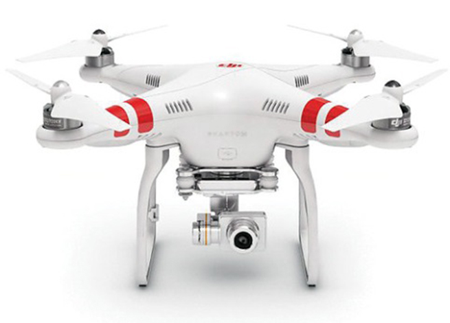
Exemption No. 11138 has been granted to Realtor Douglas Trudeau of Tierra Antigua Realty in Arizona. Most people have come across real-estate promotional stuff, maybe house-hunted using websites with lots of pictures of houses and sometimes videos, so this might be a good example that most people can relate to for using a UAS.
Phantom 2 Vision+ quadcopter UAS.
Realtor Douglas Trudeau.
Let’s look at what Trudeau has done to get his exemption and what he needs to do to use his three-pound Phantom 2 Vision+ quadcopter UAS, equipped with a lightweight video camera, to take real-estate pictures and videos.
First of all, he applied to the FAA unmanned aircraft systems office for an exemption. This involved picking through 14 CFR Part 21 regulations and looking for specific sections that he asked be waived so he could fly his UAV.
The exemption first lays out in detail the regulations from which Trudeau requested relief. Then it summarizes the information he supplied, including:
Details of the Phantom 2 Vision+: a three-pound quadcopter with four rotors driven by electric motors, battery powered. Maximum speed, 30 knots.
Area of proposed operation is near Tucson for real-estate listing videos.
Proposed operation in reasonably safe and in controlled places away from power lines, street lights, airports and actively populated areas, and there will be extensive preflight inspections where safety is of primary importance.
Proposed that aircraft certification requirements be waived.
Indicated that 2-6 inch markings on the UAV would be impractical.
Requested that regular aircraft maintenance be waived in lieu of preflight checks.
Indicated that while private pilots are prohibited from commercial operations, he can safely operate a UAV (no passengers or crew), that a pilot’s license will not ensure the skills necessary to fly a UAV, and the risks are much lower. Nevertheless, Trudeau did make an application for a 120-day temporary airman certificate to give him time to get a private pilot’s license.
Indicated that he’s already flown lots of practice flights in remote areas in different weather conditions.
Propose a safety/flight manual be with the UAS ground station rather than on the UAV.
Use of GPS with a barometric sensor rather than a standard aircraft altimeter.
That regular aircraft fuel reserve levels don’t apply to a battery-powered UAV.
Trudeau also proposed a number of restrictions on how he would operate the UAV:
Operations would be below 300 feet and within 1,000 feet of the controller to maintain direct line of sight and only 3-7 minutes per flight.
Land whenever there was low battery power.
Use the GPS flight safety feature whereby the UAV hovers and then slowly lands in the event of radio-control link failure.
Post pedestrian warning signs and continuously improve his own safety protocols.
Inform local airports — if within 5 miles — of estimated flight time, duration, elevation and other pertinent information.
Always obtain all necessary permissions prior to operation.
Have procedures to abort flights if there are safety breaches or any potential danger.
The FAA posted Trudeau’s application for waivers on the Federal Register asking for comments, and got five responses — two in support and three raising concerns, one of which opposed the idea. The trade associations that responded were the Air Line Pilots Association International (ALPA), the National Agricultural Aviation Association (NAAA), the United States Hang Gliding & Paragliding Association (USHPA) and another group, the Small UAV Coalition.
ALPA felt that UAS operators should be required to have a commercial pilots’ license. NAAA and USHPA had similar concerns about operator licensing. The Small UAV Coalition disagreed on pilot licensing for small UAVs. NAAA had concerns about low-level operations that may conflict with crop-spraying operations.
There were also a number of concerns about how this UAS would be operated and potential safety issues. The FAA agreed with these issues and has added a number of restrictions within the exemption, including the use of a visual observer, that the pilot be a current FAA certificated private pilot, and that a notice-to-airmen (NOTAM) be issued prior to operations.
The Small UAV Coalition supported Trudeau’s petition, suggesting that the FAA apply regulations differently to small UAVs rather than those of air transport/general aviation, rather than include all seven key factors — beyond visual line of sight (VLOS), weight, size, altitude, airspace, geographic area, and proposed technology — and consider Trudeau’s safety protocols, including his posting of warning signs, to enable operations in populated areas.
The Small UAV Coalition proposed that the FAA’s safety evaluation of UAV operations should not hinge on the type of operation (public, commercial, recreational or philanthropic) rather the operational risks and steps to eliminate or reduce risks. The coalition also commended Trudeau for his “Personal Protocols and Controls” document that details how he will contact any airport within 5 miles of proposed UAV operations.
In the end, the FAA granted Exemption No. 11138 with an additional 35 restrictions. Here’s a brief summary of those restrictions:
The exemption only applies to Trudeau’s Phantom 2 Vision+ UAS.
Indicated airspeed not to exceed 30 knots.
Altitude not to exceed 300 feet above ground level (AGL).
Operation always within visual line of sight (VLOS) of the Pilot In Command (PIC).
There must also be a visual observer (VO), who is in direct contact with the operator.
Trudeau has to have all the documentation and paperwork with him during operations, presumably so they can be reviewed by FAA personnel. If he makes any changes, he has to include updates in the paperwork.
Prior to flight, he must inspect the UAS to ensure it’s OK for safe flight. Any maintenance or changes to the vehicle must be documented in the aircraft records.
Record any alterations or any maintenance, and there must be a recorded test flight.
Pre-flight records must be made of inoperable components, items or equipment.
The operator must follow the UAS manufacturer’s aircraft/component, maintenance, overhaul, replacement, inspection and life limit requirements.
Maintenance, inspection and alterations must be noted in the aircraft records, including total flight hours, description of work accomplished, and the signature of the authorized person returning the UAS to service.
The UAS operated must comply with all manufacturer Safety Bulletins.
Any corrective action to fix discrepancies found between inspections must be recorded.
The operator must have at least a private pilot certificate and at least a current third-class medical certificate, and meet the required flight review requirements in an aircraft in which he’s rated.
He has to log 25 hours operating a rotorcraft UAS, and 10 hours with a multirotor UAS, before flying to make any real-estate videos.
He has to log 5 hours operating this make of UAS, and make three take-offs and landings in the preceding 90 days.
He has to demonstrate he can safely operate the UAS, including making evasive and emergency maneuvers and maintaining appropriate distances from people, vessels, vehicles and structures.
The UAS can only be operated during daylight in acceptable visual conditions.
The UAS cannot be operated within 5 nautical miles of an airport.
The UAS cannot be operated less than 500 feet below or less than 2,000 feet horizontally from a cloud or when visibility is less than 3 miles.
If the UAS loses communications or loses GPS signal, it must return to a pre-determined location within the planned operating area and land or be otherwise recovered.
The flight must be aborted in the event of unpredicted obstacles or emergencies.
A flight cannot be started unless (considering wind and forecast weather conditions) there is enough power to fly and land as intended and still have 30% battery power left.
Trudeau has to obtain a Certificate of Waiver or Authorization (COA) prior to conducting any operations under this grant of exemption. This COA will also require him to request a Notice to Airman (NOTAM) not more than 72 hours in advance, but not less than 48 hours prior to the operation.
He has to mark the UAV with a regular aircraft N-Number, which can be as large as practicable.
The radio control link has to comply with Federal Communications Commission (FCC) requirements.
The required documents must be available at the UAS Ground Control Station any time the UAS is operating, and must be made available to the FAA or any law enforcement official upon request.
The UA must remain clear and yield the right of way to all manned aviation operations and activities at all times.
The UAS may not be operated from any moving device or vehicle.
The UAS may not be operated over congested or densely populated areas.
Flight operations can only be 500 feet away from any people vessels, vehicles and structures, unless protective barriers are in place. If anyone or thing penetrates this protection zone, operations must be terminated. Property owners must approve operations, and there first has to be a safety assessment to ensure there is no “undue hazard.”
Each flight operation must be conducted over private or controlled-access property with the permission of the land owner/controller.
Any incident, accident or flight operation that goes outside operational boundaries of the area of the approved COA must be reported to the FAA’s UAS Integration Office within 24 hours. Accidents must be reported to the National Transportation Safety Board (NTSB).
Otherwise, his operations must comply with all applicable parts of 14 CFR — the full set of requirements for owning and operating a regular aircraft.
Quite a list, admittedly with quite a bit of repetition, but in all, Trudeau probably has his work cut out to cope with getting a private pilot’s license, not operating within 5 miles of an airport (since his area is right next door to one), and not fly over densely populated areas (since most real-estate is in suburbs with people, streets and houses everywhere). These seem to be the major impediments to what he wants to do.
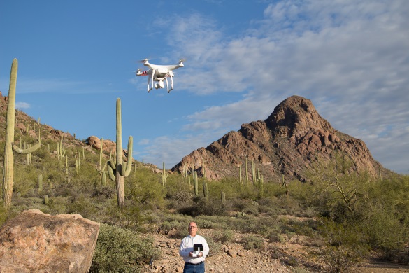
When I talked with him, I found him unfazed by all this, and he is moving down the list, satisfying the requirements — he’s already got a pilot in training who’s done his three take-offs and landings and is accumulating operating hours, with Doug Trudeau the Visual Observer. He has a binder ready to carry around all the documentation, and applying for his first COA is the next step.
Doug Trudeau training with his Phantom 2. Photo: Phantom
Meanwhile, in California, a lawyer named Dana Hobart has been asking some good questions and got a piece published in the Los Angeles Daily Journal, “Recreational Drones are Facing More FAA Headwinds.”
Hobart argues that since 1981, anyone flying a model recreational aircraft has been exempted from FAA regulations. He says that the small consumer drones currently on the market fall within the FAA’s model-aircraft exemption. For these model aircraft, the FAA only encourages users to voluntarily stay away from populated areas and airports, avoid flying near full-scale aircraft, and fly below an altitude of 400 feet. It’s unclear if model aircraft can be flown for money, such as taking videos of real-estate to help sell houses.
But Hobart goes on to stress that recent incidents where UAVs may have tangled with commercial aircraft likely means that the days of unregulated recreational aircraft are coming to a close. Indeed, the NTSB ruled that a drone is an “aircraft” and the FAA has full authority to regulate all aircraft, whether or not it is “manned or unmanned, large or small.”
With a half million drones already sold in the U.S. over the past three years, and many more in the pipeline for purchase at a rapidly increasing rate, its possible that recreational UAS use might outstrip that of commercial “for money” applications.
I’ve also heard in the past that with this volume of vehicles coming into frequent use, the FAA risks losing all control of small UAS (sUAS) unless it quickly publishes regulations. Unfortunately, the FAA continues to delay release of appropriate sUAS rules — delays that are now being counted in years rather than months or weeks — while the urgency of the situation seems to be growing daily.
Hobart gave me something to think about when he compared a motorcycle with a small UAV — in terms of the “limited damage” that either could cause to others and to property. They do seem to be similar in damage-causing capability — in fact, a motorcycle might make pretty big holes in things because it’s pretty heavy and can go pretty fast! In the case of a motorcycle, we allow people to take a two-day intensive course on safety and operation, and then turn them loose on our roads and highways. Before things get totally out of control, something similar for sUAS operators might be in order.
The FAA indeed may be moving in this direction when it began collaborating with the Association for Unmanned Vehicle Systems International (AUVSI), Academy of Model Aeronautics (AMA) and the Small UAV Coalition, who represent the vast majority of UAS users and manufacturers, on the “Know Before You Fly” UAS Safety Campaign. These organizations hope that the campaign will help ensure the safety of the skies for all aircraft, both manned and unmanned. It would be good to see a formal UAS operator qualification program come out of this.
So if you bought your kids a radio-controlled helicopter for Christmas and have been out in the backyard flying it — look out! It’s now a recreational drone and woe betide you if it had a camera and you were taking video of your house. You may need an Exemption if you give your kids an allowance and encourage them to gain skills flying their toy.
Probably not a good example, really, but this particular Exemption does seem to have gone a little over the top.
Who is MicroPilot? For almost anyone in unmanned aerial vehicle (UAV) electronics — or, rather, avionics — MicroPilot is probably a familiar name. The company makes the autopilots that basically fly the vehicle. An autopilot is the business-end of the navigation guidance system on a UAV. It takes input from sensors — typically GPS, air data, and inertial/gyro, which can be internal or external to the autopilot — and provides signals that adjust the flight controls to null out errors between the planned flight track and the actual flight profile that the UAV is flying.
A typical UAV autopilot uses GPS/inertial/air data to generate position information for route and waypoint navigation as well as hold modes where altitude and heading are maintained. In addition, it will accept commands from a remote ground-control station to modify the waypoints and route, to go to a specific waypoint, or to land, circle or fly a particular pattern. Telemetry data is also sent to the ground station to monitor status and flight progress. The autopilot acts as a central point within the UAV, communicating to and controlling onboard equipment such as pan-tilt cameras and transponders. The autopilot is also responsible for handling a variety of error conditions, such as loss of communication link or GPS.
MicroPilot was started 20 years ago by Howard Loewen, who is the sole owner and CEO. A licensed pilot, Loewen decided to make a model plane fly all by itself. With a bunch of aero textbooks, a couple of model airplanes, a single-board computer, gyros and a GPS receiver, he basically taught himself how aircraft fly and how to model (simulate) an aircraft. He developed autopilot software and a basic six-degree-of-freedom (DOF) simulator. Linking the simulator software to the autopilot software, he could test fly the autopilot on his PC. This same architecture is still in use at MicroPilot today and enables much more efficient development and testing of autopilot systems.
After many thousands of hours of simulated flight, actual flight testing was, at first, quite difficult for him to master. However, he gained lots of experience during a successful flight test campaign. Then Loewen put together a web page describing what he was doing. Not too long after the web page went live, the phone began to ring, and not long after the phone calls started, orders began to come in. MicroPilot wasn’t the only company selling autopilots at that time, but it may be the only one from that time that is still around.
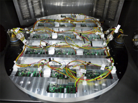
The company staff jointly decided that they should focus on the high-end commercial UAV market, so there had to be significant investment in production and development processes. Early on, an automated sensor calibration system was developed, which has recently been upgraded to use a two-axis rotating temperature chamber. This system allows MicroPilot to load up a couple dozen autopilots, and a few hours later fully calibrated and tested autopilots emerge! So, peak demand is readily accommodated, and MicroPilot staff is able to focus on product and process improvement rather than on labor-intensive manual testing.
The professional market is a more challenging customer base because customers fly much more expensive vehicles. While there is currently a lot of focus on low-cost hobby autopilots, these are seen as an interim step until there are proper regulations. In the end, UAVs are aviation products, and for many applications they require a high level of reliability and availability. No one is going to be flying 55-pound helicopters over a city without an autopilot that has undergone vigorous validation and verification processes. MicroPilot autopilots have a large number of options that enable configuration of the control system for the type of vehicle — for instance, fixed wing, multi-rotor, helicopter, or aerostat/blimp. Once the type of vehicle has been selected, the gains of the various feedback loops that control the vehicle are configured. There are also quite a few options for payloads and other onboard devices such as transponders and cameras.
MicroPilot is based in Winnipeg, Manitoba, Canada. The city is large enough to have a pool of talented engineering and computer science graduates. While the winter climate can be quite harsh, the city is not so large that there is much trouble finding a place to test fly. The MicroPilot facilities are about six miles outside the city, and the staff is able to test fly right outside their building under a Transport Canada special flight operations certificate. MicroPilot has 27 employees, ships in the order of 1,000 autopilots per year, and has 850 customers in 70 countries.
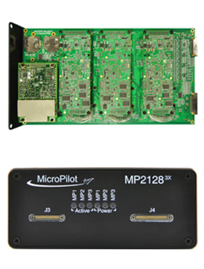
Regulation is the key to moving the commercial UAV market forward — a huge market is already flying sophisticated, expensive sensor payloads over cities. Even a moderate-size Multirotor UAV poses some safety risks, and it is important that regulators quickly devise rules to allow safe flight of these sensors over populated areas. MicroPilot has been working on improving its product offerings so that when regulations finally appear, the company will have products with the right capability and implemented correctly, so regulators should be able to readily establish that its products are safe. To this end, the first triple-redundant autopilot was introduced four or five years ago. It is still the only triple-redundant UAV autopilot available. Triple redundancy implies that two out of three channels could totally fail, and no failure will carry over from one channel to another, so autopilot functionality for the vehicle would still be maintained.
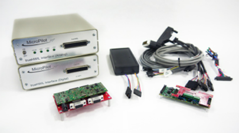
trueHWIL is a high-fidelity simulator that MicroPilot has developed where the sensors are stripped from the autopilot and the sensor inputs are simulated electrically. The simulator also reads control-position information from the autopilot. Under this simulator, the autopilot receives sensor data as if it is in the air. The code paths that the autopilot software executes are identical to those in a real autopilot in flight. Customers use this tool to build “iron-bird” simulations of the vehicle on the ground to validate the configuration prior to flight. It enables week-long or longer instrumented flight tests to be performed that would be difficult or dangerous to perform in real life.
trueHWIL high fidelity simulator. Photo: Micropilot
Finally, the xtender validate product has been developed. This requirements capture system allows customers to link system requirements to autopilot or ground control system (GCS) settings. It also allows the system designers to develop electronic flight-test cards linked to requirements. After flight test, the resulting data logs can be linked back into the xtender validate database and will also be automatically linked to the requirements used to define the flight-test card. This simplifies the flight-test process and allows managers to see that the system requirements have been completely exercised by flight testing.
MicroPilot integrates a number of different GPS receivers into its autopilots, including Trimble, u-blox and Novatel.
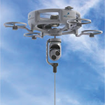
Sky Sapience in Israel has developed a unique HoverMast-100 solution for short-range, over-the-horizon reconnaissance. This UAV on a tether requires a high level of stabilization, which the MicroPilot autopilot enables. The tether allows for deployment up to a height of 50 meters within seconds, and the UAV can carry a 13-pound payload for a video camera, IR sensor, laser rangefinder, RF relay or other sensor — real-time data is transmitted to users over a wideband radio link. Armed forces in the United States, Israel and Asia are using the HoverMast-100. Commercial applications include power-line inspection, oil and gas pipelines, security, perimeter security, oil rigs, boats, agriculture, communication, sports events and disaster relief.
MicroPilot’s customer base is worldwide, with almost 1,000 different organizations having dealt with the company over the years. The range of applications goes from researchers flying a very odd vehicle with the ailerons split into a dozen segments (each controlled separately) all the way to customers using the system for traditional intelligence, surveillance, and reconnaissance (ISR), such as Bluebird Aero Systems. There are also customers that make multi-rotors (the proS3 in Italy) for a variety of data-collection needs; customers that fly targets (Avartek of Finland); customers that fly helicopters for video filming and emergency responders (Bertin in France and Helicam Pro in Italy); and customers that use UAVs in aerostats (Top I Vision in Israel). There are also a bunch of universities doing research using UAVs, and a couple of customers flying turbine powered UAVs.
So, for a significant number of UAV manufacturers and operators spread around the world, MicroPilot has become the supplier they rely on for autopilot solutions. And with the FAA now issuing what seems to be daily exemptions that allow commercial use of UAVs, it’s good to know that at least one autopilot supplier is already working towards the reliability and availability that certified applications of these vehicles will ultimately require.
In the time since my first article on indoor location, I’ve learned that there is a whole lot to this indoor location technology and business. A number of companies are taking on the indoor challenge, but few have so far successfully cracked this nut.
Rx Networks in Vancouver, Canada, is one of those few who have not only found solutions that work and work reliably, but it has also found a way to commercialize their solutions and make money.
Its embedded software and services are used daily in more than 1 billion devices — mostly smartphones, some machine-to-machine (M2M) installations, tablets, laptops, and wearables. That is some claim!
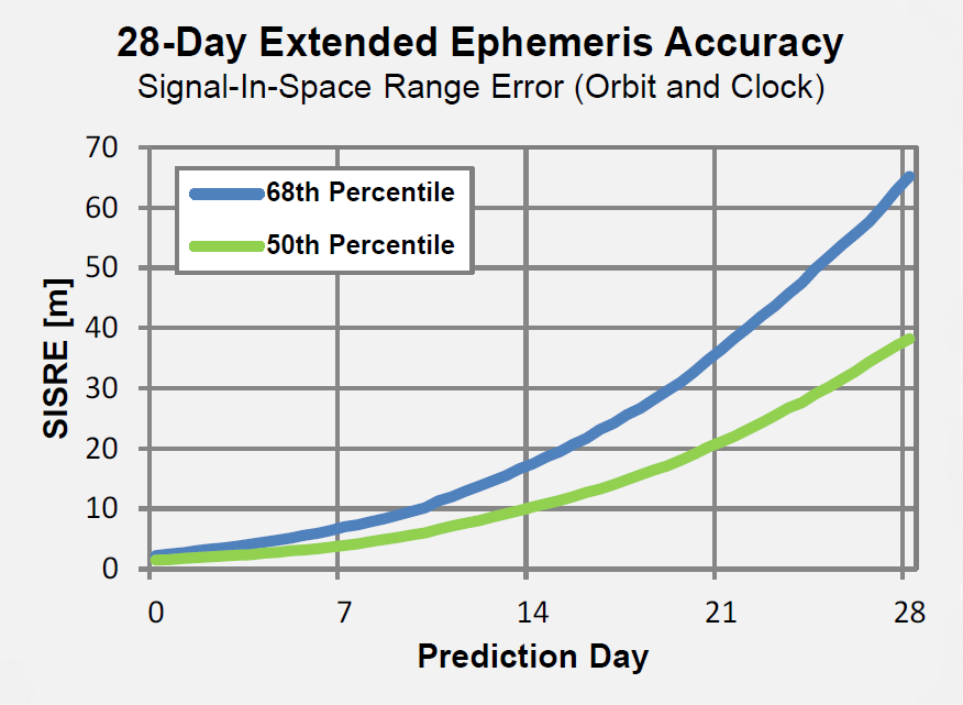
Daily transactions are primarily requests for A-GNSS assistance data, but also include requests for location based on Wi-Fi and Cell-IDs. Devices are using various Rx software and/or services, which include any or all data from a four-constellation reference network (GPStream GRN), extended ephemeris (GPStream PGPS), and Wi-Fi/Cell-ID positioning (XYBRID RT).
Founded in 2006, and still privately held, Rx is currently profitable. The head office is in Vancouver, and the company has a remote office in Atlanta, Georgia. Rx Network provides GNSS assistance-data to nearly all North American mobile operators and to several international carriers, helping those customers comply with current E-911 requirements and also offer other location-based services (LBS). In anticipation of a potential FCC “indoor” E-911 mandate, Rx’s offerings have been expanded to provide the location of devices where GNSS is not available. Its patented IP is also licensed through major GNSS semiconductor vendors and, in several cases, directly to the smartphone manufacturers.
Rx’s global reference network (GPStream GRN) is the foundation of many Rx solutions, including real-time assistance data and predictions. The service supports GPS and GLONASS, and will soon incorporate BeiDou and Galileo — the data is used by mobile operators and service providers and as an input to other products like XYBRID Cloud, where assistance data is supplied to a cloud-based positioning engine. And GPStream PGPS supplies data from the reference network to create seed files that generate extended ephemeris on smartphones.
The Rx worldwide network of GNSS reference stations. Photo: Rx Networks
There may be growing concerns about the status of the nascent Galileo constellation, but back in May, there was good signal coverage at times in Vancouver, Naples, and Prague. This enabled Rx to conduct testing on behalf of the European GNSS Agency (GSA) in challenging signal environments. The tests confirmed that Galileo significantly improved the accuracy of location-based services in urban canyons and indoors. Galileo signals were incorporated in the positioning solution with various combinations of GPS and GLONASS.
A new product known as XYBRID Cloud — a “cloud-based software receiver” — is going to trial shortly with a major U.S. carrier interested in using Rx’s indoor GNSS capability to locate small cells, home phone units, and other assets that carriers have to manage. The latest release of Cloud is providing an acquisition sensitivity of –166 dBm, which is claimed to be the best in the industry.
The XYBRID Cloud system. Photo: Rx Networks
XYBRID Cloud captures I & Q data transmitted by satellites and sends it to a cloud-based positioning engine to determine location. This is in contrast to sending it to a receiver engine on a chip within the device. This is automatic, but is not really done for a “user” as much as for an asset such as a Wi-Fi access point, small cell, or other device that someone wants to locate.
Because these devices are often deep indoors, they may only see a few milliseconds of GNSS signals every now and then, so a real-time GNSS chip receiver would never get a fix. However, XYBRID Cloud assembles the captured data over time and is eventually able to record the location of the asset. This may take a few minutes or a few days, but a fix comes together eventually. Given that these assets are normally in fixed locations and seldom if ever move, such delays are not an issue, but knowing their location or if they’ve been moved can be quite valuable.
XYBRID RT/Synchro. Photo: Rx Networks
Another Rx product, XYBRID RT/Synchro,provides Wi-Fi and Cell-ID indoor and outdoor positioning using observed Wi-Fi and -tower signals, both with and without an active network connection. The systems works in real time (RT), and Synchro uses local datasets (regions) for Wi-Fi and other radio beacons that are downloaded into the user device whenever their signal is detected. Each “region” can be tailored to best suit a user’s general location, such as a metro area, city or other venue. The system is capable of a fast GNSS fix with improved sensitivity, or can fall back to basic Cell-ID/Wi-Fi positioning. Location is available indoors with an accuracy of 5-10 meters, depending on the quality of the regional datasets.
Zed provides floor-level detection based on barometric pressure data. Photo: Rx Networks
Zed is able to provide floor-level detection based on barometric pressure data to within a vertical accuracy of 1-3 meters. Zed combines a global pressure reference with crowd-sourced data for fine-grained performance. This improves Wi-Fi location accuracy and supports Wi-Fi crowd sourcing with altitude geo-tagging.
So, Rx indoor solutions can use various combinations of these three products depending on the capabilities of the user devices. XYBRID RT provides location indoors using Cell-IDs, but more often uses Wi-Fi for more accurate positioning. XYBRID Cloud provides location of assets by sending any observed satellite signals to Rx servers for processing. Zed provides a calibration and ground-level reference pressure for a device, typically a smartphone equipped with a barometric sensor. Applications include location determination for smartphones, tablets, and wearables, and XYBRID Cloud finds assets like access points, small cells, Bluetooth beacon gateways, and home phone systems. Three companies are currently using Rx technology in the wearables space — a sports watch, augmented reality glasses, and heads-up display cycling glasses.
Other services supplied by Rx include worldwide Assisted GNSS (A-GNSS):
GPStream GRN – Relies on data collected from the Rx worldwide grid of reference receivers for GPS, GLONASS, BeiDou and Galileo. Data is compatible with all popular positioning servers from leading vendors such as Ericsson, NEC, NSN, Qualcomm, and TCS.
GPStream PGPS – Predicted GPS is an efficient handset-based extended ephemeris A-GNSS solution which supports GPS and GLONASS, for both connected and autonomous operation. Galileo is slated to be demonstrated at the Naviteq conference in December and to be available in 2015 along with BeiDou.Each device equipped with the PGPS client accesses Rx servers at least once every 14 days and downloads a small seed file that is used to create extended ephemeris for each constellation for the following 14 days.
The GPStream PGPS software. Photo: Rx Networks
Rx claims that its A-GNSS services have “carrier-level reliability” — that is to say, 99.999% availability per year.
Rx semi-conductor customers use an IP package that is embedded in processor chips for cell phones. They typically go on to supply Rx software (GPStream PGPS) with their GNSS chips, which is then run on a phone’s host processor — designed in at the factory as part of the phone.
OEM customers buy Rx GPStream PGPS software either directly or from the GNSS chip manufacturer and design it into the smartphone at the factory.
Mobile operators and service providers buy A-GNSS data that is delivered to mobile phones using location-based services for 911 caller location and LBS. Rx also supplies these customers with data containing the locations of Cell-IDs and Wi-Fi access points.
It’s good to hear that someone is already making a living with indoor location. And with so many signals of opportunity, inertial and pressure sensors now being used to “help” or actually completely replace GNSS, the era of indoor testing seems to be giving way to everyday consumer use. The average consumer will likely not realize when they seamlessly transition from outdoors GNSS guidance to “indoor” signals driving their smartphone map inside the mall. Or how really difficult it is for GNSS guidance to work in downtown when they automatically get A-GNSS assistance data that keeps their car map guidance on the correct street. Good for consumers, good for the telecoms guys, and good for the GNSS industry.
After the death of Mao Zedong, who had himself changed the “cultural” face of China, Deng Xiaoping led China from 1978 until his death in February 1997. During that period, China advanced economically further than it did in the previous 200 years, and rose from a financial backwater into one of the world’s largest economies. From 1978 to 1998, GNP increased 500%, average annual income rose from a few hundred dollars to $1,800, savings increased 14,000%, and exports went from $10 billion a year to $153 billion. In a Chinese 1998 survey, Deng was named the number-one hero in China.
Deng Xiaoping.
To achieve all this, there had to be a strategy — a vision of how to bring about such significant change. The approach chosen was to lead and support through government-sponsored initiatives — and the group who was in the best position to be able to convince people and demonstrate by example was China’s well-educated military.
So now we get to GNSS, and of course one of these initiatives was to emulate what the U.S. had done and to create its own satnav system. So we have the BeiDou/Compass space and ground control infrastructure. And having built all this, indeed they did come and a Chinese GNSS industry began to emerge. But it nearly didn’t happen.
In 1994 as part of Deng Xiaoping’s efforts, a state company was formed to pursue economic reform. Ruxin Zhou was one of those military guys who was there, and he recognized that the planned military BeiDou satnav system could be an avenue towards a huge commercial opportunity for China. But the Chinese military was already launched on a course to build BeiDou for their own purposes, and maybe they didn’t want to get caught up in these economic changes going on with the civilian population. As a member of the government advisory group, Colonel Zhou worked long and hard to promote his concept with several levels of government and to persuade military leaders and those involved with BeiDou that they should participate in Xiaoping’s reforms. Ultimately he was successful, and BeiDou eventually emerged as a joint military civilian system.
The next step was to somehow create a commercial business out of all this. To do that, in 2000 Mr. Zhou formed Beijing BDStar Navigation Company Ltd. with only himself and another original founder — Mr. Jianhui Li. Based in Beijing, BDStar was ideally located close to the government, close to military management, and close to the BeiDou operations and control centers. Coincidentally, around the same time, NovAtel in Calgary was beginning to be active in the region and was looking for dealers to market its OEM receivers into China. After a trial phase with a couple of dealers, it was finally agreed that BDStar would represent NovAtel exclusively in China.
That’s when I first met Ruxin Zhou — with U.S. WAAS development well underway, it turned out that China was also interested in creating its own Satellite Navigation Augmentation System (SNAS), and was considering NovAtel’s WAAS GI reference receivers for the ground infrastructure. Mr. Zhou became the contact point between NovAtel and BDStar, and what followed was what appeared to us to be a lengthy, frustrating negotiation which rolled out in both China and in Canada. Now we know that not only was the SNAS program making sure it understood the technology inside the NovAtel WAAS receiver, but Mr. Zhou was also learning English, the ways of doing Western commercial business, and, most of all, he was getting to know and be comfortable with us.
NovAtel went on to win three contracts to supply 85 WAAS receivers to the SNAS system over three years, and the relationship with BDStar and Mr. Zhou became one which both sides wished to grow and prosper. NovAtel OEM receivers were also supplied in quantity into a number of applications that BDStar developed in China over many years. BeiDou was also an important catalyst to initially help BDStar gain traction — the company equipped 40,000 fishing boats with BeiDou messaging receivers over several years, used for basic communication across the fleet and for location reporting to monitor authorized fishing areas.
Fast forward to today. Almost 15 years have gone by. Mr. Zhou is now chairman of the board of the BDStar Navigation group of companies, and Mr. Li is president, running day-to-day ongoing business at BDStar. I sat down with my old friend in Tampa at the Institute of Navigation (ION) GNSS + Conference to catch up with the growth and expansion of this business and listen to the many achievements that have now turned BDStar into the largest (¥780 million RMB = $127 million US) GNSS-based public company in China. BDStar had a difficult beginning between 2000 and 2007, like many start-ups, but has now emerged as a profitable leading enterprise within the Chinese BeiDou industry.
Ruxin Zhou, Chairman of the Board, BDStar Navigation.
Ruxin Zhou was born in March 1963, and he has been involved in China’s GNSS industry since 1994. He lives in Beijing, and is the father of two sons. He is also vice chairman of the Association of GNSS of China. He earned his BSc degree in 1983 followed by his master’s in 1989, both at University of NanKai in Tianjin. His MBA was awarded by the University of Beijing in 2003.
Ruxin Zhou considers BeiDou an important part of the GNSS industry, and he is looking forward to cooperating with other GNSS related companies inside and outside China to add more value to users.
Mr. Zhou chairs the BDStar board of directors — one of whom is the president of the company. There is also a group chief technology officer (CTO), a board secretary who is responsible for investment, three outside directors from industry, and an advisor who is familiar with government financial policy. Along with the parent company BDStar Navigation Products Division and its internal GNSS Applications Division, there are nine subsidiary companies, each of which is governed by a small management board.
BDStar Information Service Co. — Largest BeiDou operations service provider.
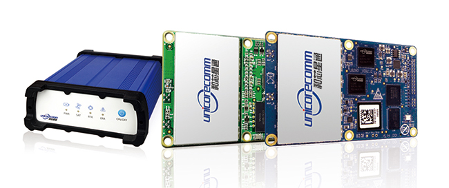
Unicore Communications, Inc. — Consumer and precision chipset and board-level receivers.
BDStar Hong-Kong — Import/export company for the group.
Shenzhen XG Electronics Co. — Vehicle electronics and installations.
BeijingSinsTek Technology — MEMS inertial technologies for defense.
Beijing Hanvic Photoelectricity Co. — Navigation using IR/photo–electric technologies.
BeiDou Information Equipment Co. — National Defense equipment and services.
Recently, the BeiDou Equipment Division within BDStar has become a separate company known as BeiDou Information Equipment Co., and another company — Harxon, which manufactures antennas — is in the process of being added to the group.
The number of people working within the BDStar group has grown from an initial staff of 20 when Mr. Zhou and Mr. Li began operating the company, to around 1,500 people today in 2014.
BDStar Navigation is where this all began as a value-added reseller for NovAtel OEM receivers — integrating them into a number of applications, such as vehicle, marine and military navigation installations. BDStar was also instrumental in the establishment of the ground infrastructure for SNAS and took part in the construction of the system. As this business increased, installations became focused within a separate group, along with building the equipment using integrated NovAtel GPS and inertial OEM equipment — the GNSS Applications Division.
With an increasing number of satellite launches, and a growing ground infrastructure, BeiDou began to become a more important part of China’s GNSS/navigation infrastructure. BDStar began to play a larger role in the emerging BeiDou program (BeiDou System or BDS), and it became clear that BeiDou technology would have to be developed by BDStar in China. And so the spin-off and company start-up phase of BDStar’s growth got underway.
BDStar Information Service Co., Ltd.
BDStar Information Services Limited is a wholly owned subsidiary of BDStar Navigation, providing location-based system solutions and information services, based on the BeiDou Navigation Satellite System, for the fishery, agriculture, forestry, water conservancy, and meteorology industries. By integrating Internet and mobile communication networks with geographic information, BDStar Information Service has now become the largest BDS information service provider in China with more than 40,000 BeiDou end-users, hundreds of government users and more than 100,000 mobile phone users. The service is 24/7/365 and includes real-time positioning, and short message communication for typhoon warnings, emergency alarms and other related services. The system has capacity for over 100 million navigation positioning and communications messages per year.
Ship terminal. Photo: BeiDouBeidou Operational Service Center. Photo: BeiDou
Unicore Communications Inc. (Beijing)
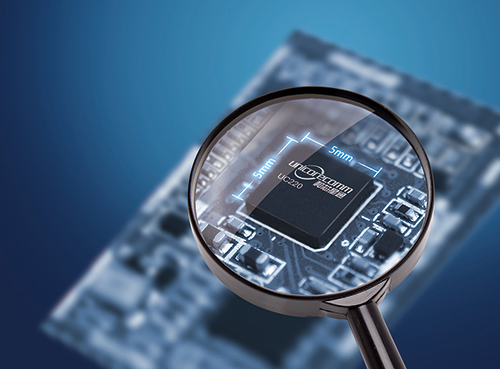
Unicore Communications Inc. is a share-holding subsidiary of BDStar Navigation — a high-tech company dedicated to highly integrated system-on-a-chip (SoC) IC design and GNSS algorithm development. Unicore is focused on the commercialization of BeiDou through advanced GNSS professional applications and innovative technology breakthroughs — one of the leading Chinese companies involved in the “industrialization” of BeiDou systems.
Unicore provides turn-key location-based services (LBS) in both the GNSS professional and consumer navigation segments. An innovative core chip has been independently developed, providing high-performance GNSS as well as low-cost, low-power, high-quality products with positioning accuracy ranging from millimeter all the way up to meter levels. Not only have high-precision requirements for surveying, mapping and CORS reference stations been satisfied, these components have also been used in less onerous applications such as vehicle monitoring and personal navigation.
By the second quarter of 2014, Unicore has sold more than one million BeiDou SoC chips and won multiple breakthroughs in BeiDou multi-GNSS applications such as in-dash automotive navigation, automatic driving test system, Ground-Based Augmentation System (GBAS), and the International GNSS Monitoring and Assessment Service for Open Service (iGMAS).
Beijing Hanvic Photoelectricity is a share-holding subsidiary of BDStar Navigation targeted at the infrared thermal imager market. The company has used in-house infrared optics, imaging circuitry, image processing, artificial intelligence, mechanical structures and system engineering to develop a number of products using planar and linear arrays. Short-medium-long-wave infrared cooling thermal imagers can provide users with a visual context under varying weather conditions from up to tens of kilometers from a target object. These products are widely used in scientific research, electrical distribution, forest-fire prevention, surveillance, public security, firefighting, and anti-smuggling.
Beijing SinsTek Technology Co., Ltd.
Beijing SinsTek Technology is a shareholding subsidiary of BDStar Navigation specializing in the original development of inertial navigation, inertial measurement, and measurement and control systems and devices- for which SinsTek owns all related intellectual property rights. SinsTek has independently developed products such as high-precision quartz accelerometers and gyros, mixed inertial navigation systems, missile-borne computers, a missile overload switch and a ground control system. Products and systems have been widely used within China in various fields of national defense and also commercially.
Shenzhen XuGang Electronics Co., Ltd.
Shenzhen XuGang Electronics was founded as a shareholding subsidiary of BDStar Navigation in 2001. The company undertakes product development, design, manufacture and sales of medium- to high-end consumer-level vehicle audio-video navigation products and services. The company has more than two decades of experience in automobile accessories, and has good cooperative relationships with China’s major automobile manufacturers. With a marketing network that extends across China, the company is one of the most important automotive electronics and navigation products providers in China. Automotive products are also exported to the U.S., Russia, Brazil, Israel and to other countries.
The scope of this business includes:
CAR navigation/CAR audio original design manufacturer (ODM) — High volume/high-quality production of auto accessories, auto electronics and GNSS products.
Marine radio ODM — Waterproof hi-fi player/radios have won wide recognition in Europe and the U.S. This is the only Chinese company whose SIRIUS satellite radio technology has been certified in the U.S.
Telematics auto network solutions — BDStar auto navigation system and BDStar Black Box have been independently developed, fusing sensors, network communications, processing and controlling technologies to provide telematics products and services for auto makers and commercial consumers.
BeiDou online telematics. Photo: BeiDou
Navigation Products Division
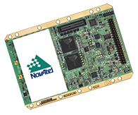
The Navigation Products Division has successfully collaborated for more than 10 years with NovAtel as its value-added reseller (VAR) of GNSS and GNSS-inertial products in China. Focused on satellite positioning and inertial navigation applications, BDStar has promoted domestic Chinese navigation and positioning applications development, and has established close cooperative relationships with domestic inertial and integrated mapping companies, research institutes, and other sectors. Application fields include railways, electricity, telecommunications, meteorology, and seismology. Quite naturally, independently developed BeiDou products have also followed this route to market in China.
NovAtel OEM6 receiver. Photo: BeiDou
GNSS Application Division
The GNSS Application Division is the business division of BDStar Navigation, which is mainly engaged in the development, production, sales, and service of the products based on high-precision GNSS technology applications. With the objective of becoming expert in high-precision GNSS solutions used in the developing industry using the “Internet Of Things (IOT),” the company provides a series of GNSS terminal products and solutions for the civilian market. Applications have included agriculture, container ports, and deformation monitoring. Meanwhile, the successful port IOT that this division has provided for Tianjin Port has now been implemented at more than 20 domestic and foreign ports including Shanghai, Ningbo, Shenzhen, and in India.
BeiDou Internet of ships Photo: BeiDou
BeiDou Information Equipment Co.
BeiDou Information Equipment, a wholly owned subsidiary of BDStar Navigation, is focused on supplying products for national defense and government agencies, and provides complete solutions and products for dispatch management of hazardous materials and special cargo handling. Several successful projects have been undertaken, including special hazardous vehicle command and monitoring, public security, anti-terrorism, forest-fire prevention, emergency management, personnel command and monitoring of disaster relief, public security, and border defense. The division relies on its experience in system engineering, command and control software, radio system design, and military satellite navigation to provide users with terminal products such as navigation, timing and heading, and location-based military information service systems. Specific products developed include terminal equipment, vehicle-mounted navigators, vehicle traveling data recorders, police positioning and telecommunication terminals, and an emergency communication system.
Following this phase of significant growth, what does the future hold for BDStar? We know that China’s huge annual rate of GDP growth may have slowed a little, but Mr. Zhou still has pretty big aspirations for his group of companies. His target for 2020 is to have BDStar reach annual sales of 10 billion RMB ($1.63B US). To get there, his intermediate step is to reach 2 billion RMB ($326m US) by the end of next year. Overall, this represents a ten-fold growth in revenue over six years — by Chinese industrial standards, this might even be termed “modest” growth.
But where will all this growth come from? The strategy appears to be textbook:
Through significant organic (internal) growth, or by doing the same things better and to a greater extent.
Through strategic partnerships with targeted leading companies in key growth areas.
Through further acquisition of companies that would improve the bottom line and also benefit from the synergies of the existing corporate group.
While the anticipated course would be to add companies at the corporate level, it’s possible that some companies within the organization may also get to the point where they see adding an organization below or alongside may become a profitable avenue for their own growth. Of course, other suitable companies in China would be on Mr. Zhou’s strategic acquisition list, but he’s also looking for expansion elsewhere around the world. The U.S. market is significant for the type of products and technologies available in the BDStar group, so it would be natural to anticipate that a North American acquisition could help improve product distribution and development. As BeiDou becomes an integral part of global GNSS, and industry partners seek more than Open Service capability and better Chinese access, its also conceivable that partnerships with North American players could come about.
So, at least with BDStar and some other similar Chinese companies, it would seem that those earlier 1990s aspirations of the Chinese government to create a commercial economic sector within the Chinese economy have at least begun to show a measure of success in the GNSS market segment.
ION GNSS+ is more than satellite navigation, with lots of options for aiding, augmenting and even replacing GNSS, both indoors or outdoors. There were a few less exhibitors this year, but just as many attendees as last year, and lots of good quality technical, commercial and interesting topics in the paper and panel sessions. And, in the customary discussions around the show, there was as much catch-up andspeculation over recent events as usual — all in the beautiful surroundings of Tampa, Florida.
Tampa is a pretty nice place, especially at this time of year as the summer heat is dying and the humidity is down. Then there are lots of things to see and do in Tampa and all those Florida attractions over in Orlando, if you bring the family with you and can find a few extra days to use as vacation.
The ION exhibit was slightly smaller (57 booths versus 63 last year) — Javad, for one, didn’t exhibit with his regular large booth, and the USAF testing guys didn’t show either — but the number of attendees (1,000+) was pegged at around the same as last year.
So, although the commercial exhibit might have been down a little, the popularity of ION GNSS+ is still there, and the location helped too, bringing a bunch of people to take a look at South Florida. ION made considerable effort this time around to appeal to the wider business aspects of the industry, and it had a number of successes doing this. So, let’s assume that as we emerge from a somewhat flat business phase that industry growth will resume shortly, and ION attendance will reflect that growth in future years.
Some companies introducing new products included IFEN with its new SX3 software receiver, Altus with the APS-NR2 integrated antenna/wireless/GNSS RTK receiver, Unicore with the UM220-INS GPS/Beidou receiver with integrated six-axis MEMS and the UB280 dual-antenna GPS/Beidou receiver, and Comnav,which also introduced a dual-antenna heading receiver. For most other OEM companies at the show, it was more status quo, and they were at ION checking out their competition, visiting with existing customers, showing hardware for potential customers to “kick the tires” and meeting with others to pursue new longer term business opportunities and potential collaboration efforts.
The scuttlebutt around the recent Galileo launch anomaly was headed up by ESA’s assurances that everything possible was being done to rescue its rogue FOC (full operational capability) satellites, circularize their orbits, and use them in the constellation. Then there were several variations on potential sabotage conspiracy theories, and others proposing that a solution to the problem could be to just quickly build and launch more satellites — maybe not on Soyuz. Spending new money on replacement satellites and new Ariane launches rather than on a protracted science project to rescue these lost SVs — this seemed to be favored by most North American pundits.
Septentrio, along with introducing a new RTK engine, made an organizational change, integrating Septentrio and Altus, and combining product marketing efforts for both companies’ products. Septentrio’s Jan Van Hees will now not only be the market lead for Septentrio’s products, but also Altus’ products, and both marketing organizations will now work closely together. Executive Director Peter Grognard was also in Tampa, leading his usual high-energy charge for Septentrio and the European GNSS industry. Altus has also added industry veteran Mo Kapila as OEM sales manager for Septentrio products. Kapila is based in Altus’ office in Torrance, California.
More organizational changes may follow at NovAtel, as Executive Vice President Graham Purves moves out to take the reins at Hexagon’s recently acquired Veripos subsidiary. Graham was born in Scotland, so he’s returning to his roots as he moves to the Veripos Aberdeen office from NovAtel’s base in Calgary, Canada. Graham and Hexagon may be watching for the results of the Scottish independence referendum, which should be known shortly after the vote Friday, September 18. However, negotiations with the UK government — required by a “yes” vote — may drag on for some time after. If this all comes about, maybe it will allow sufficient time to assess the potential impact on Veripos’ operations.
Indoor Location
ION held a panel and demonstration session on indoor location, reflecting the huge interest in indoor E-911 and commercial indoor applications. One of the leading outfits working the indoor problem using beacons is NextNav in California, who chose not to demonstrate its capabilities. However, I did learn that NextNav is active in around 47 urban markets, is setting up another large trial in Seattle, and has recently acquired another $70m investment in the last few months. Rx Networks was also there to show its latest assistance and location products including Zed, a service that calibrates pressure sensors to determine floor level, and XYBRID Cloud, a cloud-based GNSS engine that achieved GNSS fixes down to 2 meters inside the exhibition hall where there was otherwise no GNSS coverage.
The Indoor Location Panel discussion was around establishing standards for development of indoor location capabilities — there were eight panel members and apparently four prevailing standards areas/groups involved in developing standards for different aspects of what essentially is a wide field of differing communications systems. For someone involved in making and using one common standard for a particular GNSS and aviation industry application, this session was basically baffling.
The interesting indoor location story at the show came in the following afternoon session, where seven companies set up live (or close to live) demonstrations in a large area on the first floor of the Tampa Convention Center, where there was little prospect for any GNSS sky signals to penetrate. There were a number of Wi-Fi access points (AP) set up in the room, along with a Nokia beacon.
Basically using the Wi-Fi APs, and their vertical measurement Zed, the Rx team was trying to show static positioning of their location in the demo room. They certainly had a hiccup during the demo and may have lost a bunch of accumulated data, but they didn’t comment on what appeared to be large errors they showed on a Google Earth representation of the convention center.
This team was using a Round Trip Timing (RTT) method, ranging off the three Wi-Fi APs, and measuring location and collecting data on a smartphone. To demonstrate its ranging accuracy, Broadcom measured range to an AP using a laser rangefinder and demonstrated high correlation with the range measured by RTT.
Using Wi-Fi ranging and integrated MEMS inertial for Pedestrian Dead Reckoning (PDR), CSR plotted a path walked round the room, with what appeared to be pretty good accuracy. CSR also indicated how magnetic/compass measurements can be thrown off by ferrous structures in buildings.
Following an initial crash and a quick restart, PNI ran an excellent demo of plotted position on a tablet using a 15-state Kalman Filter using extremely low-power gyro, accelerometers and mag-sensor (PDR), which also indicated mag-sensor errors.
Indoo.rs indicated that its solutions are fielded commercially and use Wi-Fi fingerprinting and iBeacon/Bluetooth tracking sensor fusion, with added floor-plan constraints when available. Unfortunately, efforts to follow a smartphone around the room with a video camera did not capture the demonstration for the audience.
Navizon claimed 1-2 meter indoor accuracy using Wi-Fi finger-printing, BLE iBeacons, and inertial, using a portable software solution it provide to integrators. The systems works best when the system is “trained” using a floor plan and PDR. A YouTube video recorded earlier was used to demonstrate the system’s capabilities.
Nokia presented its angle-of-arrival technology with HAIP RF tags and a remote positioning server, which was demonstrated with tags on radio-controlled cars, with a tablet display that indicated that tracking appeared to be highly accurate.
So, to summarize, the participants were very brave to attempt these real-time demos and most pulled off the challenge, with varying degrees of success and demonstrated accuracy. This would seem to indicate that the anticipated FCC ruling for new indoor E-911 location requirements could well be met by existing technologies.
Interference and Anti-Jamming Systems
One of the big things at the show was the Signal Sentry 1000, an Exelis product that detects and locates GPS interference sources in 3-D. Given that Exelis is also connected to jammers and the U.S. Department of Defense, it’s not unusual that the company has found a way to bring a system to the commercial market that finds jammers.
A lesser known, much smaller offshore outfit is also working with jammer/interference detection. GPSat Systems Australia related its involvement in the GGPS RF Jamming and Spoofing Detection and Geo-location Technology projects, in cooperation with the Universities of New South Wales (UNSW) and Adelaide (UA).
After four years of development jointly funded by the Australian Research Council and GPSat Systems, the output from combined research into jammer detection and geolocation by UNSW and UA is starting to bear fruit. Two papers were presented showcasing their weak interference detection and localization techniques, followed by a project update and preliminary field trial results.
The technology focuses on combining the performance of multi-element, high-gain, steerable-beam antenna arrays producing angle of arrival (AoA) data, along with centralized time difference of arrival (TDOA) spectral processing of jammer signals arriving at different sensor nodes. Combining the two techniques provides the best options for successfully geolocating both swept CW and broadband jammers at substantial stand-off distances.
GPSat Systems is now under contract to further extend this technology to include spoofer detection for future deployment with the Australian defence services. GPSat Systems anticipates that the civilian L1 version will be introduced to the market by early 2015, and the military version by middle 2016.
The GNSS world needs more help to halt the “jamming plague,” and GPSat seems to have a solution that a number of organizations may want to look into.
So, another ION GNSS+ conference is in the books, with lots of GNSS news and interesting developments on a number of fronts. Not a whole bunch of new OEM-receiver-related products, but a whole mess of indoor location systems pushing the technology envelope and the promise of more to come. I hope Galileo gets it right chasing their lost birds, that new company organizations flourish in the coming months, and that we have more jamming detection and anti-jam solutions to talk about at next year’s conference — which will once again be down among the palm trees in Tampa.
I was born in the UK, so I still have a soft spot for people and things going on there. I really enjoy those PBS Mystery dramas, and, of course, Downton Abbey. Where’s this going? you might ask. It’s basically to preface an overview of a GNSS outfit I know quite well, which operates out of Lancaster in northwest England.
Forsberg Services Ltd. (FSL) has been around as a consulting company since 1987, when Charles Forsberg began the company, developing marine engineering solutions and, beginning in 1999, also representing NovAtel OEM GPS in the UK and the Middle East.
In 2002 the company was reconfigured as a navigation systems engineering company. With a number of successful programs underway in both the UK and Germany, FSL went on to open an office in Würzburg Germany, in 2002. At the same time, FSL won its first major naval contract with the CPUpak — an interconnect enclosure containing both SAASM and commercial CA-code receivers, which distributes GPS data to multiple systems. The CPUpak is now on several countries’ mine-countermeasure vessels (MCMV). It was also developed as an inertial navigation system as a key part of naval vessels’ air operations certification systems.
CPUpak is on a number of MCMVs.
FSL is still privately owned, has 26 employees, and considers itself a “design house” for vehicle manufacturers, the marine industry, defense contractors, cellular operators, and television networks. It is an ISO9001-certified R&D partner to several blue-chip companies for navigation systems.
Today, its primary activities include:
selling and supporting off-the-shelf FSL and NovAtel GNSS products and providing associated customer service,
custom engineering solutions developed over very tight timescales,
research into new and emerging markets and development to create new opportunities,
managing production of FSL products and also for key customers.
As NovAtel’s dealer in UK and Germany, FSL markets and services the full range of NovAtel OEM products, including the latest OEM6 GNSS receivers, Waypoint inertial and post-processing software, Antcom antennas, and Raven Starlink RF components.
NovAtel GAJT anti-jam system, OEM6, and Pinwheel antenna.FS-D6 processor module.
FSL has developed a number of key building blocks to enable further integration and production of various GNSS enclosures based on common hardware and software designs. This has allowed FSL to develop multiple systems in parallel and to expand the level of support provided through its dedicated team of engineers. The FSL-developed FS-D6 processor module and EDGE-WARE firmware it runs, along with the earlier FS-M4 microcontroller and FS-D5 DSP module, have become key building blocks that have enabled the creation of other products.
ReACT integrated GNSS/antenna.
The ReACT smart antenna was first produced in 2011, and has been qualified to appropriate mil-spec standards for use on military vehicles, with RS232/422, USB, and CAN interfaces providing data outputs. The unit has a sturdy, waterproof enclosure for operating in harsh environments, with up to 5 serial, 3 USB and 2 CAN interface channels to hook up other sensors. Applications have included INS and dual-antenna heading reference for military vehicles; agriculture; reference navigation for optical navigation; and photogrammetry.
MICROpod.
The MICROpod unit houses up to two GNSS receivers, and comes with a heading/attitude determination option. A MICROpod telecoms application involved supplying GNSS data to each radio network controller (RNC) to provide AGPS (assisted-GPS) data over the cellular network — the objective was to improve the start-up time for supporting emergency services. A less-expensive solution than installing separate GNSS receivers with each RNC, but certification to CE/FCC and IP67 was essential. The solution was the MICROpod eight serial ports along with firmware that made each RNC think it was connected to an independent receiver. Within the processor, the inbound commands and outbound data were managed to ensure that the system was serviced as expected. The whole project had extremely tight timescales — from contract award in August 2008, to first delivery on-site in the U.S. in November. The system was designed, developed, certified and passed test, all within three months! Around 400 systems are now installed across sites in the U.S. and around the world.
The unit has a sturdy IP65 enclosure, with up to 10 serial, 3 USB and 2 CAN interface channels to hook up other sensors. Other applications for MICROpod have included sub-10 nanosecond time synchronization of LIDAR, Earth observation/IR cameras, third-party INS, networked military vehicle/vessel navigation and data communications, pulse-train generation for coded equipment operations, and precision velocity measurement. Another variant has been customized and qualified for Train Control Network (TCN) applications.
FSL has also dabbled in a couple of “glamorous” undertakings along the way, such as providing inertial/GPS dynamics measurement for the Red Bull World Series air races in Abu Dhabi, and also race-car inertial/GPS tracking and camera slaving for TV. A byproduct of the race-car project was a patent for a computer game using race data for vehicles that took part or could actually be played live during a Grand Prix on a particular circuit from a participating car.
Abu Dhabi air race aircraft.Air race graphics.GTR evolution game patent.
An interesting oblique photography application involved aircraft fitted with DSLR and video camera as well as other EO/IR sensors, their position and orientation measured by inertial navigation all feeding into FSL’s OPTOnav. A recent enhancement has been release of an in-flight bore-sight calibration. This is essential when navigation and camera choice may only be applicable for a single flight, and rapidly rendered results are necessary. The system works with a choice of cameras. For one project, an advanced GSS C516 compact five-axis gyro-stabilized platform and INS have been configured with Canon 1DC, Corona and Red Dragon cameras. The resultant ground positions are comfortably accurate to better than 1 meter at 500-meter range in real-time. This is despite GPS antenna often being fitted in less than ideal locations such as inside the cockpit of some aircraft.
The FSL OPTOnav product originated in 2006 as a piece of software installed on a rubber-tired gantry crane in a container port. The customer was experiencing problems of crane drivers being unable to see that they were drifting off course and moving outside of track, creating a safety risk. The crane is shaped like a staple, where the driver sits on one leg with the container in between the legs. As a result, the other leg cannot be seen clearly. This system is currently being enhanced so that it may utilize the latest technologies.
The software takes feeds from a GNSS receiver and from cameras. Using these inputs, a pattern and line-matching algorithm was developed to provide drivers with a centimeter-level indication of whether they were to the right or left of a safety line, along with the heading of the crane’s cameras to better than a 20th of a degree. This data was used to augment the GNSS in challenging areas, and unlike INS, simply doesn’t drift. During the development, a number of obstacles including shadows, reflections and obstructions were overcome.
This work leads to an RT version, which augments RTK GPS in obstructed sky locations, and a PP version, which supports precise point positioning aided GPS for applications such as photogrammetry. The system may be used to measure precise ranges to targets, and position is determined by triangulation. Simple, accurate and effective!
Measure the same point in multiple shots at different angles and distances: OPTOnav provides a 3D position.
So, let’s recap. That’s project management of contracted hardware, software and production to very short timescales; sales and support of GNSS; inertial and optical navigation; and OEM products from NovAtel, Waypoint and Antcom. That’s lots of options — along with access to markets in UK, Germany and elsewhere, and specialist applications in photogrammetry, machine control, survey, telecommunications and systems integration. So, although Forsberg Services Ltd. may be one of many outfits around the world in the value-added reseller (VAR) game, it certainly has enough irons in the fire. And it has demonstrated the quick turn-around of a small, flexible organization with a track record of success — so Forsberg Services should anticipate a bright, growing and interesting future.
TECTERRA is an Alberta government initiative to encourage and support start-ups in the geomatics field in Canada. In June, TECTERRA held its annual Geomatics Showcase at the TELUS Centre in downtown Calgary, where 56 companies and four universities had booths to exhibit their wares, tell their stories, and hopefully generate business.
Since May 2010, TECTERRA has provided $30 million in repayable loans, matched by an $18 million investment by the companies receiving assistance. As companies begin generating revenue from products or services coming out of these programs, they are required to incrementally repay the TECTERRA support funding.
The money TECTERRA has contracted to companies has come through a number of funding programs from the province of Alberta and from the government of Canada. The combined investment is estimated to have generated $58 million in economic benefit to date and is projected to generate a total of $300 million over the next few years. TECTERRA defines geomatics as, “The collection, management, integration, analysis and display of geographic information describing the Earth’s physical features and the built environment.”
A total of 46 industry-led product development and commercialization projects and 25 applied research projects have been supported, and in the process, 10 patents have been filed and another 45 are in development. Eleven companies have started to generate revenue and hence begun making repayments to TECTERRA, while two companies have already completely repaid their loans.
So the bottom line is that TECTERRA appears to be underwriting a portion of the development risk for the companies and projects it supports, and more innovative geomatics concepts are therefore making it through to the market and into useful applications. TECTERRA not only analyzes the financial business case of each project submission, but also pulls together an experienced engineering/academic review team that really digs into the technical viability of the candidate projects. At the show I came across the following Geomatics Industry Association of Canada (GIAC) estimate of the scope of geomatics in Canada:
Canada has 20% of the world market, with 40% of that coming from Alberta.
A CAGR (Compound Annual Growth) of 15-20%.
More than 2,500 companies.
35,000 people working in the industry.
Just about all the TECTERRA companies have come up with a solution that in some way incorporates, uses, or supports GNSS — this is apparently one of several criteria for a TECTERRA project. In walking and talking around the exhibit, I was more drawn to those applications where GNSS is one of the core technology ingredients.
That doesn’t mean to say that these products or companies are more or less likely to succeed or that their application could be better or worse or more or less viable. The province (Canadian for “state”) of Alberta is oil and gas country — and Calgary is a hub for a large number of outfits that supply and support the oil and gas industry. Spin-offs of large and small companies abound, and the half-life of businesses seems to grow shorter every year, but the same people seem to crop up in related ventures all the time, continuously driving technology and business innovation. Working in isolated areas, oil and gas workers are often on their own, miles away from civilization. Companies, however, ensure good communication with their people via repeaters and satellite phone connections. Nevertheless, the time when remote workers most need assistance is when they may be incapacitated and unable to call home base for help.
AbsoluteTrac originally began its operations in the firefighting industry, providing tracking and diagnostic data for pilots. In 2013 it merged with Gemini Positioning Systems to form Absolute Gemini Ltd. The combination of both organizations provided the ability to develop a new hardware product line tailored to a wide range of industries. The strong foundation from Gemini Positioning Systems for work-alone safety allowed all the development work that went into real-time remote worker alert systems over those years to be available to the private sector market, and is in use with a number of oil and gas companies.
With the ability to send automated check-in and emergency messages, the SafetyLink Pendant (SLP) can identify when a user becomes motionless or is in distress. Incorporating the use of a standalone GPS/GLONASS receiver, 3-axis accelerometer, Bluetooth and ZigBee technology, the SLP is compatible with all popular smartphone operating systems via the SafetyLink application, and the TRULink hardware series for equipment monitoring and vehicle tracking. Absolute Gemini Ltd. is a machine-to-machine (M2M) integrator, and has worked closely with a variety of vendors including Blackline GPS — another TECTERRA exhibitor in the booth right next-door.
AbsoluteTrac SafetyLink Pendant.BlacklineGPS Lōner alert device and Bridge cell/sat base repeater.
Rx Networks (Rx) is another well-established company offering, among other things, A-GNSS extended ephemeris.
Rx CEO Guylain Roy-MacHabée left, with booth staff.
Rx has been supplying indoor/outdoor solutions for E-911 and LBS using Wi-Fi/cellular/GNSS hybrid positioning for smartphones for several years. Its technology and services are used and accessed by most of the major cellphone OEMs and mobile operators. Integrated pressure sensors and “Zed” reference pressure data supply vertical accuracy of 1 to 3 meters for automatic floor-level and map selection. Rx has established a 23-site worldwide GPS, GLONASS, BeiDou and Galileo reference network using NovAtel receivers, which is compatible with popular positioning servers from leading vendors such as Ericsson, NEC, NSN, Qualcomm, and TCS.
GPStream PGPS is the company’s ASIC embedded extended ephemeris product that supports GPS/GLONASS, with both connected and autonomous operation — BeiDou and Galileo support is expected to be available shortly. LiDAR Services International(LSI) is a Calgary-based airborne LiDAR survey company that seems to exclusively use NovAtel precision GPS for its DGPS/RTK base stations and also for airborne GPS reference data collection. NovAtel SPAN inertial/GPS systems are also integrated within its in-house proprietary-developed MATRIX LiDAR systems. LSI has 20 people, with offices in Calgary and Las Vegas, and operates three airborne LiDAR systems. LSI has collected LiDAR data on five continents.
The layman’s explanation of LiDAR that I picked up at LSI was just enough to make me dangerous, if I wasn’t already pretty lethal. The LiDAR projects up to 500,000 laser pulses/second onto the area being overflown, picks up reflections, and calculates ranges for each pulse. Geocoding using both GPS and inertial then allows post-processing development of a three-dimensional point-cloud image of the surveyed area. For most surveys, LSI also collects digital imaging that can be used to overlay and further reference the point-cloud image.
One interesting application is in power-line surveys where weather data is concurrently collected with LiDAR data, so that wind speed and temperature may be used to calculate cable “sag,” not only from one survey to the next, but also for calibrating weather effects. This data has been used to allow power companies to gain insight into cable power-loading versus cable power-rating — enabling safe and secure increases in loading on existing transmission lines rather than building expensive new lines. LiDAR is also a key tool for vegetation management along transmission corridors. LSI was launching its pipeline leak detection and monitoring subsidiary GAS RECON at the show. We’ll learn more in the future about their plans for “sniffing out” gas and oil leaks from pipelines.
BlackBridge Geomatics was another Canadian company at the show — it probably deserves a mention just on the basis that it has its own constellation of five RapidEye Earth Observation (EO) satellites. No other Canadian companies seem to have that capability, and BlackBridge just announced funding for its next generation of EO satellites. RapidEye enables complete coverage of difficult-to-image areas, and imagery collected by the RapidEye constellation fills archives with large quantities of current geospatial information on a daily basis.
RapidEye satellites can collect up to 5 million km² of imagery daily, which allows BlackBridge to quickly provide large-area coverage and monitoring services for customers. BlackBridge is also the exclusive Canadian distributor for Airbus’ SPOT satellite imigary, and is a North American distributor of the DigitalGlobe WorldView 1 and 2, GeoEye-1, Quickbird, and IKONOS constellations. Lots of other companies were at the TECTERRA Showcase, with geomatics applications and other elements that contribute to a geomatics solution. Here are a few more I talked with:
Mobizou — uses mobile location to advertise via smartphones to potential customers
As I mentioned, there were a whole bunch of Canadian geomatics outfits at the show, and many more deserve a mention — please check out the Showcase Exhibitor List on the TECTERRA website and visit a few of their websites. Peter Mansbridge is a famous Canadian broadcaster whose appearance at the show may have increased attendance. His stand-up presentation was interesting and humorous, and was aimed at answering the question, “What is a Canadian?” Not many in the audience could have answered the question — it’s something we Canucks puzzle about constantly (it’s a cultural thing). However, through this show, TECTERRA has enabled us to understand a little better the contribution being made to geomatics by a significant group of Canadian start-ups and some more mature companies.
Most of you will know that during summertime I can usually be found in Calgary, Alberta — the “GPS Capital of Canada.” I usually try to pick up on developments in this area, and having recently bumped into my friends at Baseband Technologies, I found that they have made significant progress since the first time they appeared in my articles a number of years ago.
Baseband has now been around for 10 years, and has always focused on building reliable applications which are an adjunct to basic GPS, improving performance for integrated GPS in cell phones and other portable devices such as personal location watches, glasses, tracking devices, and such. Cell phones, of course, have had integrated GPS for a long time for personal navigation and 911 location.
Baseband aims to provide “instant position” with extremely low-power, low-cost positioning technologies. The company has several patents well into the approval loop, and have drawn heavily on the GNSS-rich’ availability of skilled people in and around Calgary for its significant R&D.
Baseband’s first product offering is a self-contained GNSS RF front-end that enables capture of satellite signal data for its cloud-based snapshot positioning receiver. The software receiver kit allows integrators to readily build prototypes that integrate Wi-Fi, Bluetooth, Ethernet, cellular modem, MEMS sensors, memory, and LCD that is compatible with the Arduino open-source electronics prototyping platform to quickly test and validate new product concepts. The snapshot receiver can also be integrated with other OEM hardware to greatly improve time-to-first-fix (TTFF) and power consumption. For customers who want to integrate snapshot positioning into silicon at the chip level, or into other hardware or software, Baseband offers system design services and a simple licensing scheme.
Nevertheless, acquiring satellites can be somewhat of a delicate operation for regular GPS receivers, and this can be especially true when a receiver is operating downtown where open sky can be intermittently blocked by buildings. The net effect is that a receiver could take a long time to calculate position, or sometimes even fail to provide a position altogether. Time is money, or in the case of cell phones, battery power is everything. So reducing power consumption and TTFF is something that a lot of OEMs are interested in achieving.
Turns out that pulling ephemeris or satellite location from satellite data can be the real issue, as the data rate of the satellite for this information is so slow. To get an initial position from four satellites could take between 16 and 36 seconds under best-case conditions — normally in a downtown core or dense forest this ideal situation is rarely achieved, and acquisition times can be much longer and become a real problem for users. Imagine how frustrating it could be for people like taxi cab or delivery trucks drivers operating downtown, where users have to constantly operate in harsh environments and may be subjected to loss of position data due to ephemeris renewal many times during a day.
Depending on the receiver that you’re using, satellite ephemeris may only be valid for up to four hours, whereas Baseband’s extended ephemeris can last for up to one month and still maintain acceptable accuracy. This means once you’ve downloaded an extended ephemeris file, there is no need to download it again for another month. Instead of relying on receiving ephemeris from satellite broadcast and suffering through its limitations under poor conditions, extended ephemeris (or satellite prediction) technology offers several advantages.
With extended ephemeris, a satellite’s ephemeris is always usable regardless of data errors and gaps in the actual transmitted satellite data. In other words, satellites that the receiver can still see, but which have low signal strength, may nevertheless be used to go directly into acquiring the lower power satellite signal, generating the Doppler and code phase, and ultimately proceed to the position calculation. So Baseband has developed and is marketing 28-Day Extended Ephemeris service to address these problems.
For a regular embedded receiver working with 28-day Ephemeris, Baseband claims to reduce TTFF from 30-60 seconds down to around 2 seconds. Even in intermittent satellite signal conditions, acquisition or reacquisition isn’t necessary, so signals can still be used for tracking. Ephemeris transmissions to the device are extremely compressed, and can be as small as 20 KB per week, while accuracy is maintained. Baseband claims its patent-pending techniques provide unparalleled orbit and clock accuracy, which allows users to obtain highly accurate predictions. Client software for the user device is platform independent and has been designed from the ground up to operate extremely efficiently with low-power processors.
So there we have it — a new approach to achieve very fast initial position for portable digital devices including cell phones and a method to overcome lengthy initial position determination under poor signal conditions, with the added bonus that power consumption is also greatly reduced.
For high-volume commercial applications where GNSS performance is important, but conditions may be far from favorable, Baseband may well have something which could really improve how OEMs take advantage of more reliable position determination with longer time between battery recharges.
AUVSI Unmanned System 2014 provided a showcase for new UAV/UAS products, and a dialogue on the rapidly growing industry.
Report from the Association of Unmanned Vehicle Systems International (AUVSI) Orlando, Florida, May 12-15, 2014
Just before the start of the huge AUVSI show, the FAA once again cautioned Unmanned Aerial Systems proponents that still more care is needed with UAS airspace access. The majority of UAS operators and manufacturers are making efforts to become compliant with reasonable FAA rules. Also, AUVSI had some good information on the economic benefits of UAS commercial applications to the U.S.
The annual AUVSI conference came down to the Sunshine State this year, and the sun did shine, with temperatures in the high 80s most days. The Orlando Convention Center is a huge place and AUVSI took up the majority of the South Exhibit hall along with a bunch of rooms where most of the technical presentations were run. With close to 600 exhibitors and more than 6500 attendees, this is still one of the bigger trade shows.
FAA Rules
However, just before the start of this huge show, the Federal Aviation Administration (FAA) once again cautioned Unmanned Aerial Systems (UAS) proponents that still more care is needed with UAS airspace access. It’s probably more than a coincidence that FAA released news of a March 22 close call at 2,300 feet between a US Airways airliner on approach to Tallahassee, Florida, and a model F4 Phantom Jet — UAS owner and operator unknown. And CNN also picked it up and animated it pretty quickly. As the industry as a whole strains to seek more airspace access, it’s difficult to understand how incidents like this happen. And, in the process, they push back all the good efforts that are being made by the large majority of UAS operators and manufacturers to demonstrate their ability and desire to become compliant with reasonable FAA rules.
Nevertheless, AUVSI had some good promotional material available at the conference showing the economic benefit to the U.S. for UAS commercial applications — a $82 billion market and around 104,000 jobs over the next ten year, $50 billion in the top ten states alone.
Wildfire mapping, agriculture monitoring, disaster management, power-line surveys, telecomms, weather monitoring, aerial imaging/mapping, TV news and sports coverage, movie making, environmental monitoring and oil and gas exploration — these are just some of the commercial areas where AUVSI anticipates that UAS will generate significant revenue.
Presentations and Sessions
The conference presentations began on Monday afternoon, and one paper that caught my eye was by Sierra Nevada (SNC) on its Fusion Filter, which is designed to take multiple sensor inputs and develop navigation and guidance for en-route, terminal approach and landing. This particle filter maintains thousands of weighted position estimates and refines them to provide a composite position and guidance output. Sensor inputs that SNC has used include 3D radar, lidar, FLIR IR camera, daytime camera, GPS/INS, and digital terrain elevation data (DTED). For landing applications, ~50 algorithms run to determine runway location with or without GPS/INS inputs. SNC has flown development flight tests on both fixed wing and rotor craft.
Tuesday began with a General Session headlined by Rep. John Mica (R-Fla.), House of Representatives; Lt. Gen. Kevin Mangum, deputy commanding general/chief of staff, U.S. Army Training and Doctrine Command; and Rep. Frank Lobiondo (R-N.J.), House of Representatives. In introducing these speakers, Ralf Alderson of AUVSI talked about the change from an industry basically serving the U.S. Department of Defense to a coming UAS commercial marketplace: “Time to start learning about the rest of the world,” he commented.
John Mica chaired the House Transportation Committee until 2012, and was one of the movers behind the government’s legislation that gave the FAA its 2015 deadline to integrate UAS into the National Airspace System (NAS). Mica’s disappointing advice was for us to now think in terms of 10-15 years before there would be complete UAS integration in the NAS, largely due delays in the name of safety by the FAA.
Lt. Gen. Kevin Mangum (Army three-star) began by telling us that the Army’s first UAV may have been the SD1 Drone used in Germany in 1960/61. He indicated that everything the Army does with UAS is basically focused on providing the soldier in the field with the tools he needs to be successful. He indicated how UAS are available at the various command levels, and gave us insight into progress with manned and unmanned teaming.
Frank Lobiondo is chairman of the House Aviation Subcommittee, which oversees the majority of programs of the FAA. He acknowledged that “The rest of the country is not tuned in” to the benefits of UAS, and “sensationalized media coverage only highlights (UAS) in a very negative way.” Nevertheless, Congress is desperate to see the potential economic impact of UAS unleashed, and will urge FAA to speed up the process.
Later on at the conference, almost as if in response to Lobiondo’s comments, FAA Manager of UAS Integration Jim Williams made a welcome announcement. Four companies have approached FAA for expedited UAS approvals, and the FAA is now working with them to expedite limited commercial operations before UAS rules are finalized. Limited commercial operations for filmmaking, power-line inspection, precision agriculture and flare-stack inspection are therefore expected to be soon authorized by FAA.
The next General Session featured presentations by Alaska Lt. Gov. Louis Mean Treadwell and futurist Mike Walsh. While Walsh’s presentation was entertaining and thought-provoking. Challenging almost all status quos for how to conduct business, Treadwell had more to say that was directly relevant for today’s UAS industry. “Do consumers get it, do they want it, do they fear it?” These were the messages Treadwell gave to his AUVSI audience. As a past technology and business start-up innovator, he had a lot to say about the suitability of Alaska for UAS testing and innovation. With 47,000 people working in aerospace in Alaska, and the recently FAA-awarded Alaska-Hawaii based Pan-Pacific Test Range; Treadwell encouraged the UAS industry to come and try Alaska.
Exhibit Floor Highlights UAS Opportunities
Meanwhile, the GNSS and navigation systems suppliers to the UAS industry were going about the business of the trade show — exhibiting and demonstrating their capabilities. Wandering purposefully around the huge show floor, I set about uncovering what was new and how people felt about UAS opportunities:
Septentrio:
Septentrio introduced a new RTK engine this year, which is better in occluded situations — such as under tree canopies or around downtown buildings. It has better scintillation detection and provides clearer warning indicators to users. The bottom line is that its RTK is more robust and works better.
Septentrio has also had some significant success with major dredging operators around the world. It has reduced convergence times for PPP, say when starting with an initial RTK position, and position accuracy degrades gracefully over 15-30 minutes.
Accord:
Accord is quite excited by the prospect of a new FAA TSO C-199, which when approved will establish equipment requirements for gliders, balloons and aircraft such as micro-lights, all without electrical systems. The TSO creates a new class of equipment, which is now referred to as Light Aircraft Surveillance Equipment (LASE). The aircraft targeted for equipage are currently exempt from the rule that mandates other aircraft should carry ADS-B — which broadcasts position and velocity, allowing others in the airspace to track and avoid your aircraft. So to improve safety, a simpler, less expensive ADS-B device is being called for that uses an off-the-shelf (non-certified) GNSS receiver as the position source. The point is if this GNSS is good enough for this special class of aircraft, why wouldn’t it be good enough for UAVs, which are so similar to these targeted aircraft?
Accord has a Micro-i GPS SBAS receiver for this application using a chip-level receiver called the Navika-300, which comes from its Indian technology partners. Accord claims that the Navika is comparable to other chip-level receivers in the market from CSR (Sirf) and u-blox.
Topcon:
Topcon has partnered with MAVinci from Germany to market the Sirius Basic and Pro aerial positioning system in Europe, and presumably this system will find its way into everywhere that Topcon does business.
Achieving 5-cm GNSS-RTK accuracy without traditional Ground Control Points (GCP) increases productivity. Removing the need for placement of GCPs can potentially reduce time for a survey project by up to 50 percent. This precise positioning technology allows image locations developed by Sirius Pro to be used as the equivalent of GCPs.
Trimble:
The Trimble UX-5 Aerial Imaging Rover was probably first on the market as a GNSS/UAS system for precision surveying. Following the acquisition of Gatewing, Trimble has been working hard to bring a fully capable UAS surveying solution to market.
The Trimble UX5 aerial image data is processed into deliverables by the new Trimble Business Center (TBC) photogrammetry module. Specialized computer-vision algorithms produce accurate results automatically, with minimal manual interaction. The UX-5 provides a stable and reliable photogrammetric system delivering excellent results without requiring specialized photogrammetry knowledge or experience.
Trimble also unveiled a new high-performance integrated UHF receiver at the chipset level ( 60 x 55 x 15 millimeters), designed for OEM integrations, UAS among them. The BD930-UHF supports both triple frequency from the GPS and GLONASS constellations plus dual frequency from BeiDou and Galileo, making it ready to take advantage of additional signals as GNSS grows and grows. The BD930-UHF delivers quick RTK initializations for 1–2 centimeter positioning. It also has an advanced kalman filter PVT engine positioning in urban canyons and the like, for applications not requiring centimeter-level accuracy. The receiver also supports fault detection and exclusion (FDE) and receiver autonomous integrity monitoring (RAIM) for safety-critical applications — sure to become increasingly important in the FAA-ruled airspace and coming regulations.
The Trimble BD930-UHF high-performance integrated UHF receiver.
NovAtel:
NovAtel announced the release of the new OEM617D receiver at AUVSI’s Unmanned Systems 2014. The OEM617D is a compact, dual-antenna, dual-frequency, single-card receiver offering NovAtel’s ALIGN heading functionality and RT-2 Real Time Kinematic (RTK) GNSS positioning technology, in both dynamic and static environments. The OEM617D provides dual-frequency operation with GPS, GLONASS and BeiDou signals and also tracks Galileo, SBAS and QZSS, maximizing GNSS availability globally. Fixed and rotary-wing aircraft/UAS, marine, and autonomous ground vehicles will benefit by integrating the OEM617D as well as other applications requiring precise position and heading accuracy.
Gladiator:
The Landmark 50 is a high-performance GPS/inertial product which comes in at the top of the Gladiator MEMS inertial product line. The LandMark 50 INS/GPS represents inertial performance on par with small ring laser and fiber-optic gyros. This performance leap with low-cost MEMS technology offers substantial improvement in performance utilizing the newest high-performance MEMS gyros and accelerometers combined with a 72-channel, 10-Hz update rate u-blox GPS, GLONASS, BeiDou, QZSS and SBAS receiver.
Geodetics:
Geodetics showed off a couple of new GPS/inertial products. The Geo-ReiNAV comes in both a commercial and a mil-spec (SAASM) version. As the team was at lengths to explain, Geodetics is GPS “agnostic” — which in today’s terminology means Geodetics uses a variety of OEM receivers in their products — the smarts are in the filter and processing. The other key component is a Seiko/EPSON G352/362 MEMS Quartz IMU, which apparently has less noise and lower drift (or more accurately “in-run bias stability”) than other silicon MEMS inertials.
Incidentally, we sat and discussed this material at the Geodetics booth, which seemed more spacious than in previous years — it was larger, as it spilled over into the next vacant booth which Hemisphere was supposed to have occupied — but having apparently reserved and paid, didn’t show up for the exhibition.
Sparton:
Sparton released news of the GAINS-10 Multi-GNSS assisted inertial navigation system at AUVSI this year. The unit excels in challenging environments. It provides accurate inertial navigation in the presence of mechanical shock, transient platform vibrations and extreme magnetic interference. The 10DOF IMU features high speed, synchronous sampling of all inertial systems combined with high rate coning and sculling compensation and is fully calibrated over temperature.
Vectornav:
The VN-300 is a miniature dual antenna GPS-aided INS system. The dual GPS adds heading determination, and the inertial aiding helps through potential GPS outages. A pressure sensor is also included for altitude determination. The VN-300 can be used in a wide variety of industrial and military applications and is well suited for size, weight, power and cost-constrained applications such as unmanned vehicle systems; antenna, camera and platform stabilization; heavy machinery monitoring; robotics; and primary or secondary flight navigation.
Oxford Scientific (OxTS):
Last year at AUVSI, Oxford introduced a miniature datalogging GPS/MEMS INS — this year it returned with the xNAV500, which is now real time. With dual GPS and antenna inputs, this unit also provides heading determination in a small form factor that is apparently very affordable.
MicroPilot:
One of the leading providers of autopilot systems for a large number of the UAS at the show, MicroPilot has not stood still during the last 12 months. The latest product addition is the MP2128³× triplex redundant autopilot using three high-performance 2128ɡ autopilot boards on one pcb. The advantage is that this autopilot is fault resistant, providing two additional back-up channels to resist critical function failure. A board-level option is available for integrators who want to combine functions in fewer on-board boxes.
UTC/Cloud Cap:
Cloud Cap is also one of the principle autopilot suppliers to the UAS industry. Cloud Cap appears to pack additional functions into its range of autopilots — including a core autopilot, flight sensors, navigation, wireless communications and interfaces providing data to the payload system. The Piccolo Nano is its smallest device, and has been mounted in a board stack on top of a Cloud Cap enclosure containing a NovAtel OEM615 used as the Nano GPS navigation source.
Overall on par with last year’s AUVSI conference in Washington, D.C., the Orlando venue probably encouraged more industry participation, but there seemed to be a lot fewer military people around. This probably accounts for what looks like reduced attendance over last year.
The GNSS/navigation exhibitors, however, were just as innovative as last year, and were present in good numbers. There was generally good traffic at most of these booths, so there are probably new customers coming directly from the show. What was the most notable new thing at the conference? For me, it was discovering the potential for a reduced scope of equipment certification — provided UAS could find a way to be included within the same class of aviation as balloons, micro-lights and gliders. This would really help bring more UAS with high-performance navigation into usable airspace — even unleashing the commercial potential that Congress and the industry need so badly.