Tag: proof of concept

  • ArduSimple launches GNSS starter kit with cm precision positioning

    ArduSimple launches GNSS starter kit with cm precision positioning

    Photo: ArduSimple
    Photo: ArduSimple

    ArduSimple has announced the availability of a range of GNSS starter kits for anyone in Europe or the United States who is interested in testing or integrating high-precision centimeter accuracy for a service or product proof of concept (PoC).

    Building a PoC for increasingly common applications such as autonomous vehicles, where high levels of positioning accuracy are required, is often a complex process. Finding compatible antennas that are tuned correctly, CPUs, modems that connect to GSM, sourcing a global SIM, finding a suitable real-time kinematic correction engine that works in multiple regions, and mounting it all on a board is a lengthy and costly process, according to ArduSimple.

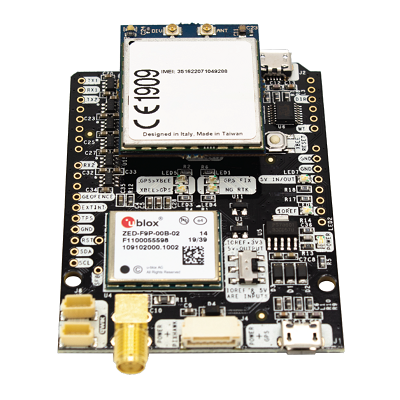
    To solve this issue, ArduSimple pulled together the components and services required into a range of starter kits that work out of the box. The simpleSSR Starter Kit  works anywhere in Europe and the United States that has a 4G signal.

    “Bringing together the components, high-precision accuracy and connectivity in Europe and the United States in one simple out-of-the-box solution will significantly speed up the process of PoC projects,” said Marc Castillo, senior consultant at ArduSimple. “We’ve reduced the complexity, enabling engineers to focus on the feasibility of their projects.”

    The kit includes:

    • 1 simpleRTK2B-F9P V3 board
    • 1 u-blox ANN-MB-00 Antenna for GNSS Dual Band with cable (IP67)
    • 4G radio module with NTRIP client including RTK-SSR engine (XBee socket compatible)
    • 2x 4G antennas with integrated cable
    • 1x SIM card with 1-year subscription
    • 1-year subscription to SSR service
  • ESA seeks ideas to augment satnav with imaging sensors, 3D maps

    ESA seeks ideas to augment satnav with imaging sensors, 3D maps

    NAVISP includes projects for autonomous and connected driving. (Image: ESA/F. Bagiana)
    NAVISP includes projects for autonomous and connected driving. (Image: ESA/F. Bagiana)

    The European Space Agency (ESA) is issuing a call for ideas to overcome GNSS service gaps in urban canyons by using imaging and 3D mapping technology. A workshop to discuss the call for ideas will be held virtually on July 6.

    According to ESA, the growing availability of high-quality image sensors and high-fidelity 3D maps — such as those within smartphone mapping apps — offer a promising way to shrink the performance gap caused by urban canyons and multipath for future mobility applications in terms of ubiquity, reliability and resilience.

    NAVISP — ESA’s Navigation Innovation and Support Programme — specifically is seeking prospects for technology demonstrations of mobility tech to support applications such as  road, maritime transport and drones. The tech would provide assisted satnav by harnessing image sensors and 3D urban models. The proof-of-concept demonstration projects or national testbeds would facilitate introduction of this technology into commercial products.

    Use cases include private or public autonomous transportation in cities, including cars, trams, scooters, bikes, urban ferries, harbors, narrow waterway navigation and future passenger drones.

    Reflected satellite navigation signals (multipath) can degrade positioning performance, especially in urban canyons with numerous artificial surfaces. (Image: EUSPA)
    Reflected satellite navigation signals (multipath) can degrade positioning performance, especially in urban canyons with numerous artificial surfaces. (Image: EUSPA)

    The NAVISP project, called a “thematic window,” is titled “Assisted GNSS with Imaging Sensors and 3-D models for Mobility Applications.” The thematic window opened on June 10 and will close on Oct. 31. During its duration, ESA is offering dedicated support to companies interested in participating in the projects and submitting outline proposals.

    On July 6, the agency is hosting an online workshop with stakeholders to raise awareness about the initiative and clarify any issues interested companies may have. ESA will present the requirements of the Thematic Window and the application process. The workshop will include presentations from high-level experts covering market perspectives, techniques involved in the use of 3D models and imaging sensors, the state of the art of these technologies and latest advances in visual navigation and artificial intelligence applied to mobility applications.

    To register for the July 6 workshop, click here. The workshop agenda is available here.