Tag: Qinertia

  • Septentrio and SBG Systems partner on Qinertia post-processing

    Septentrio and SBG Systems partner on Qinertia post-processing

    Septentrio now offers Qinertia post-processing software from SBG Systems on AsteRx-i3 D Pro+, AsteRx-i3 S Pro+ and AsteRx SBi3 Pro+ receivers

    Septentrio will now offer post-processing solutions for its GNSS/INS (inertial navigation system) receivers, using SBG Systems’ Qinertia software.

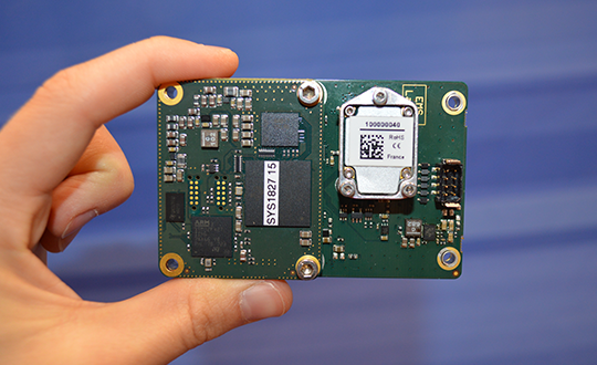
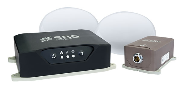
    The AsteRx-i3 Pro+ receivers are fully compatible with Qinertia post-processing software, so no data manipulation is required before the post-processing step.

    Land or aerial mapping applications, which do not have access to real-time GNSS corrections, benefit from post-processing software for higher positioning and orientation (heading, pitch and roll) accuracy. With the addition of post-processing, Septentrio GNSS/INS products cover the full mapping workflow.

    “As a result of our cooperation with SBG Systems, Septentrio’s mapping customers who use GNSS/INS are benefiting from a quicker and more reliable workflow,” said Danilo Sabbatini, product manager at Septentrio. “The intuitive user interface of Qinertia software makes it easy for users to further improve their positioning and orientation accuracy in the post-processing step.”

    In case of GNSS outage or correction link failure, post-processing recovers accuracy for recorded positioning and inertial data.

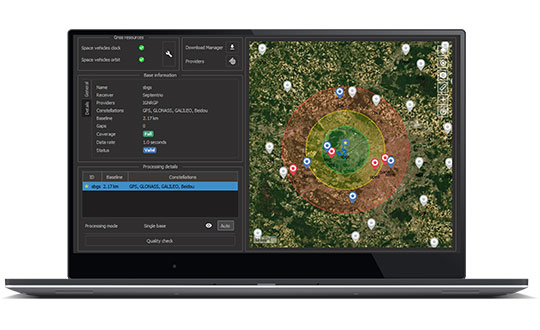
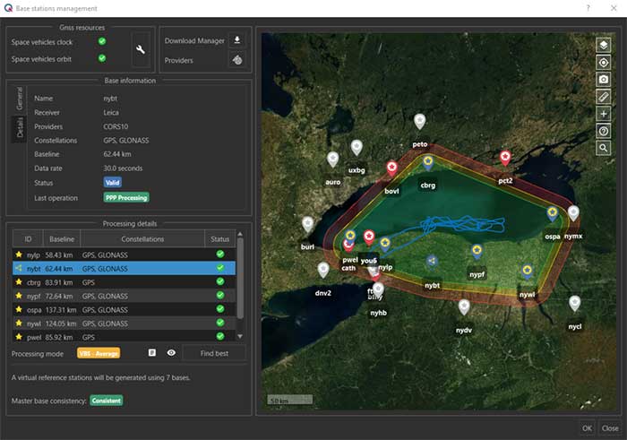
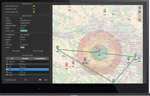
    After the mission, Qinertia gives access to real-time kinematic (RTK) corrections from more than 8,000 base stations to deliver centimeter level accuracy. Trajectory and orientation are greatly improved by post processing GNSS and IMU data forward and backward. The Qinertia GNSS/INS post-processed kinematic (PPK)  solution provides accuracy, reliability, advanced quality-control indicators, and a modern application programming interface (API).

    Qinertia recently added an image geotagging feature, and specific outputs dedicated to photogrammetry.

    Qinertia post-processing software will be used on Septentrio receivers. (Photo: SBG Systems)
    Qinertia post-processing software will be used on Septentrio receivers. (Photo: SBG Systems)
  • SBG Systems releases virtual base station feature in Qinertia

    SBG Systems releases virtual base station feature in Qinertia

    The virtual base station feature in SBG's Qinertia computes a virtual network around a project in which position accuracy is maximized, homogeneous and robust, the company said. (Photo: SBG Systems)
    The virtual base station feature in SBG’s Qinertia computes a virtual network around a project in which position accuracy is maximized, homogeneous and robust, the company said. (Photo: SBG Systems)

    SBG Systems has released a virtual base station (VBS) feature in Qinertia, its in-house GNSS and inertial navigation system (INS) post-processing software. According to the company, trajectory and orientation are greatly improved by processing inertial data and raw GNSS observables in forward and backward directions.

    The VBS computes a virtual network around a project in which position accuracy is maximized, homogeneous and robust like a PPK short baseline, SBG said. Once surveyors collect data, Qinertia chooses the most relevant reference stations, builds a virtual network and brings the project to the centimetric accuracy with no jump on accuracy nor convergence effects, even in urban areas.

    According to SBG, it has worked to offer a VBS which takes the most out of any GNSS receivers from different brands and models — with different configurations or constellations — and even with different coordinate systems. Qinertia automatically adjusts the VBS network to compensate for any base station position inaccuracy and provides full quality control indicators to assess the expected accuracy and reliability, the company added. Qinertia VBS technology can mix users base stations with permanent network base stations to improve accuracy in remote locations.

    Finally, Qinertia automatically selects the best positioning technology that applies to a user’s project, whether it is a single base station mode, the virtual base stations mode or a precise point positioning computation. Despite this, users can still take control and make adjustments — like — while Qinertia automatically re-checks and re-computes all parameters simultaneously to validate the accuracy and consistency.

  • SBG Systems offers Qinertia license for GNSS post-processing

    SBG Systems offers Qinertia license for GNSS post-processing

    Qinertia, SBG Systems’ PPK software, now supports third-party IMUs and offers a GNSS post-processing license covering all major GNSS receivers

    Screenshot: SBG Systems
    Screenshot: SBG Systems

    SBG Systems’ INS/GNSS post-processing kinematic (PPK) software Qinertia now covers all surveyors’ projects by offering a license dedicated to GNSS post-processing. Open to the world, Qinertia supports all major GNSS receivers and is now open to third-party inertial measurement units (IMUs).

    Qinertia has been designed to offer a comprehensive suite of post-processing software to geospatial professionals. It accepts all major GNSS manufacturers, and supports proprietary protocols from NovAtel, Septentrio, Trimble and u-blox for a straight-forward workflow.

    The full-featured post-processing software offers native support for u-blox F9 real-time kinematic (RTK) receivers, reducing the workflow to a simple “drag and drop” to guarantee data integrity and accuracy.

    Qinertia has been designed to help surveyors get the most of their surveys easily with a simple workflow, powerful quality control tools and tightly coupled algorithms. All of this is available to any surveyor with the new support of third-party IMUs or GNSS receivers. Several IMUs and inertial navigation systems (INS) have already been successfully integrated with Qinertia including Northrop Grumman’s LN-200 and LCI-100 and  the Inertial Sense µIMU.

    The new Qinertia GNSS license allows surveyors to post-process both static and kinematic GNSS data. In just a few clicks, surveyors can improve their trajectories, access RTK corrections worldwide, or even control a base-station’s precise location using precise point positioning (PPP) static computations.

    GIS and Photogrammetry. Whether they fly a UAV or drive a car, professionals can improve their image location accuracy. Qinertia has been designed to help surveyors get their GIS or photogrammetry projects way more precise, by exporting a centimetric position for each picture at the exact shutter event.

  • SBG Systems debuts line of inertial navigation systems at Xponential 2019

    SBG Systems debuts line of inertial navigation systems at Xponential 2019

    SBG Systems debuted its Quanta UAV series, a new line of inertial navigation systems (INS), at Xponential 2019, which took place April 29-May 2 in Chicago.

    According to the company, the Quanta UAV is a small, lightweight and low-power INS. Designed specifically for UAV survey applications, the Quanta UAV series provides precise orientation and centimeter-level positioning data delivered both in real-time and post-processing.

    “The Quanta UAV series is a new product line specifically designed for UAV applications and, more particularly, to precision applications like lidar mapping and photogrammetry,” Alexis Guinamard, chief technology officer at SBG Systems, told GPS World.

    The Quanta UAV series is also offered on two levels of accuracy: one of its most important benefits, Guinamard added.

    “The main advantage of the Quanta UAV series is high flexibility because we have two difference performance levels: the standard grade, which is suitable for most applications, and for higher altitude surveys we have Quanta Extra, which delivers improved accuracy,” Guinamard said.


    According to SBG Systems, Quanta UAV embeds a web interface for an easy configuration with a 3D view showing all parameters. Its calibration tool automatically aligns the lever arm between the two antennas and the sensor, then re-estimates it in flight for more precision. The Quanta UAV also eliminates the need for ground control points.

    In addition, the product comes bundled with one year of access to Qinertia, SBG Systems’ post-processing software, which will “enable accurate data in post processing,” Guinamard said.

    The single- or dual-antenna also adds another layer of flexibility to the Quanta UAV series. According to SBG Systems, the dual-antenna mode allows a more precision heading, which is an ideal set up for low dynamic flights.

    “I think the flexibility is the key advantage because we have these two performance levels and also the possibility to operate in real-time or in post-processing, and the possibility to operate in single- or dual-antenna,” Guinamard said. “It’s an all-in-one product.”

  • SBG Systems debuts Quanta UAV series at Xponential 2019

    SBG Systems Chief Technology Officer Alexis Guinamard gives GPS World an overview of the company’s Quanta UAV series, which launched at Xponential 2019 in Chicago.

  • SBG Systems showcases Qinertia INS/GNSS post-processing software at Intergeo 2018

    SBG System’s Raphael Siryani gives an overview of the company’s Qinertia INS/GNSS post-processing software at Intergeo 2018, which took place Oct. 16-18 in Frankfurt, Germany. The system gives access to offline RTK corrections from more than 7,000 base stations.

  • SBG Systems offers GNSS+inertial navigation for surveying, UAVs

    SBG Systems offers GNSS+inertial navigation for surveying, UAVs

    SBG Systems is launching the Navsight Land & Air Solution, high-performance inertial navigation designed to make surveyors’ mobile data collection easier, whether for mobile mapping, GIS or road inspection.

    SBG Systems will release the Navsight Land & Air Solution at the Intergeo show in Frankfurt, Germany, Oct. 16-18.

    The solution consists of an inertial measurement unit (IMU), available at two different performance levels, connected to Navsight, a rugged processing unit embedding fusion intelligence and a GNSS receiver. It also has connections for external equipment such as lidar, cameras or computer.

    Photo: SBG Systems
    Photo: SBG Systems

    The Navsight Land & Air Solution is the result of more than 10 years of experience in the mobile positioning industry, especially in the unmanned industry where position reliability is mandatory. SBG’s fusion algorithms allow the company to get the best performance from inertial, odometer and GNSS technologies; exclude false GNSS fixes; and improve the trajectory in complicated areas such as urban canyons, forests and tunnels.

    According to the company, the Navsight Land & Air Solution supports all GNSS constellations, real-time kinematic (RTK) and precise point positioning services such as Omnistar and TerraStar.

    SBG IMUs are easy to install, the company said. The sensor alignment and lever arms are automatically estimated and validated. Once connected to the Navsight processing unit, the web interface guides the user to configure the solution. A 3D view of the vehicle shows the entered parameters so that the user can check the installation. By choosing the vehicle, such as a plane or a car, the inner algorithms are automatically adjusted to the application. The Navsight unit also integrates LED indicators for satellite availability, RTK corrections and power.

    INS/GNSS Post-Processing Software. Qinertia, the SBG post-processing software, provides access to offline RTK corrections from more than 7,000 base stations in 164 countries. Trajectory and orientation are greatly improved by processing inertial data and raw GNSS observables in forward and backward directions.


  • Qinertia post-processing software now available

    After years of development and an intensive beta testing phase with key partners, Qinertia post-processing kinematic software is now being offered by SBG Systems.

    Qinertia has been designed to help surveyors get the most of their surveys, according to SBG Systems.

    After the mission, Qinertia gives access to offline real-time kinematic (RTK) corrections from more than 7,000 base stations in 164 countries — and always up-to-date. By creating a virtual base station near a project, the software delivers the highest level of accuracy without having to set up your own base station.

    An advanced tight coupling algorithm has been designed by SBG Systems to deliver the highest accuracy and maximize RTK availability. Trajectory and orientation are greatly improved by processing inertial data and raw GNSS observables in forward and backward directions, especially in GNSS challenging environments (urban canyons, forest, etc.).

    With advanced quality control indicators such as standard deviation, separations and GNSS quality feedback, Qinertia provides full understanding of a survey. With Qinertia, surveyors can quickly identify and solve issues such as mechanical installations or sensor alignment.

    Qinertia has been designed to be easily integrated in a production workflow. It supports RINEX industry standard, and Septentrio, Novatel and Trimble native binary format.

    A powerful ASCII export feature allows seamless integration with any third-party software. SBET and Google Earth are also supported for improved interoperability.

  • SBG Systems demonstrates Qinertia INS/GNSS software at Intergeo

    SBG Systems demonstrates Qinertia INS/GNSS software at Intergeo

    SBG Systems will demonstrate Qinertia, its in-house next-generation INS/GNSS post-processing software, at the Intergeo trade show, which takes place Sept. 26-28 in Berlin.

    SBG Systems can be found is in Hall 1.1, stand C1.007.

    For more than 10 years, SBG Systems has been designing inertial navigation systems from the internal inertial measurement unit (IMU) to filtering with GNSS data.

    Designed for the surveying market, Qinertia is a fully in-house INS/GNSS post-processing kinematic (PPK) software. Whether the survey is made from a car, a UAV, a plane or a vessel, Qinertia will secure and enhance a surveyor’s acquisition, the company said.

    The company will hold four live demonstration at its stand during Intergeo. The demonstrations will take place at 11 a.m. and 15 p.m. on both Tuesday, Sept. 26, and Wednesday, Sept. 27.  There is no need to book to attend a demonstration, but please note that seats are limited.

  • SBG Systems unveils Qinertia INS/GNSS post-processing software

    Qinertia, SBG Systems’ new in-house post-processing software, gives access to offline real-time kinematic (RTK) corrections, and processes inertial and GNSS raw data to further enhance accuracy and secure a survey.

    SBG Systems will unveil new software for the surveying industry at the Ocean Business show, held in Southamptom, United Kingdom, April 4-6.

    For more than 10 years, SBG Systems has been designing inertial navigation systems from the internal inertial measurement unit (IMU) to filtering with GNSS data. Expert in real-time data fusion, the company takes another step in the surveying industry by unveiling Qinertia, a fully in-house post-processing kinematic (PPK) software. Whether the survey is made from a car, a UAV, a plane or a vessel, Qinertia will secure and enhance the acquisition.

    Virtual Base Station

    After the mission, Qinertia gives access to offline RTK corrections from more than 7,000 base stations in 164 countries. By creating a virtual base station near your project, the software delivers the highest level of accuracy without having to set up a base station, the company said.

    Trajectory and orientation are then greatly improved by processing inertial data and raw GNSS observables in forward and backward directions. Qinertia also secures the survey by fixing afterwards lever arms or sensor misalignment.

    Qinertia has been designed to help surveyors get the most of their surveys with simplicity. Surveyors can begin a project with a step-by step wizard, access an always up-to-date reference station database, and consult advanced quality indicators. With 64 bits and a multi-core design, Qinertia is fast processing software.

    Qinertia will be available in the fourth quarter of this year. A public beta test program will begin early this summer.