Tag: Quanta UAV series

  • SBG Systems debuts line of inertial navigation systems at Xponential 2019

    SBG Systems debuts line of inertial navigation systems at Xponential 2019

    SBG Systems debuted its Quanta UAV series, a new line of inertial navigation systems (INS), at Xponential 2019, which took place April 29-May 2 in Chicago.

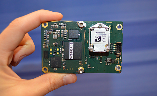
    According to the company, the Quanta UAV is a small, lightweight and low-power INS. Designed specifically for UAV survey applications, the Quanta UAV series provides precise orientation and centimeter-level positioning data delivered both in real-time and post-processing.

    “The Quanta UAV series is a new product line specifically designed for UAV applications and, more particularly, to precision applications like lidar mapping and photogrammetry,” Alexis Guinamard, chief technology officer at SBG Systems, told GPS World.

    The Quanta UAV series is also offered on two levels of accuracy: one of its most important benefits, Guinamard added.

    “The main advantage of the Quanta UAV series is high flexibility because we have two difference performance levels: the standard grade, which is suitable for most applications, and for higher altitude surveys we have Quanta Extra, which delivers improved accuracy,” Guinamard said.


    According to SBG Systems, Quanta UAV embeds a web interface for an easy configuration with a 3D view showing all parameters. Its calibration tool automatically aligns the lever arm between the two antennas and the sensor, then re-estimates it in flight for more precision. The Quanta UAV also eliminates the need for ground control points.

    In addition, the product comes bundled with one year of access to Qinertia, SBG Systems’ post-processing software, which will “enable accurate data in post processing,” Guinamard said.

    The single- or dual-antenna also adds another layer of flexibility to the Quanta UAV series. According to SBG Systems, the dual-antenna mode allows a more precision heading, which is an ideal set up for low dynamic flights.

    “I think the flexibility is the key advantage because we have these two performance levels and also the possibility to operate in real-time or in post-processing, and the possibility to operate in single- or dual-antenna,” Guinamard said. “It’s an all-in-one product.”

  • SBG Systems debuts Quanta UAV series at Xponential 2019

    SBG Systems Chief Technology Officer Alexis Guinamard gives GPS World an overview of the company’s Quanta UAV series, which launched at Xponential 2019 in Chicago.

  • Quanta UAV INS/GNSS improves UAV-based surveying

    Quanta UAV INS/GNSS improves UAV-based surveying

    SBG Systems will present its Quanta UAV series at AUVSI’s Xponential show, which takes place April 30-May 2 in Chicago. The Quanta UAV series is a line of inertial navigation systems (INS) dedicated to UAV-based surveying integrators.

    Because SBG Systems wants UAV surveyors to save autonomy for additional survey lines, the company has designed a small, lightweight, and low-power INS offered on two levels of accuracy. Quanta UAV and Quanta UAV Extra have been developed for compact lidar to high-end BVLOS mapping solutions. They provide precise orientation and centimeter-level position data delivered both in real time and post processing. This direct geo-referencing solution eliminates the need for ground control points and greatly reduces the need of overlapping.

    Qinertia, SBG’s post-processing software completes the Quanta UAV offer. It gives access to offline real-time kinematic (RTK) corrections from more than 7,000 base stations in 164 countries, the company said. Trajectory and orientation are greatly improved by processing inertial data and raw GNSS observables in forward and backward directions. This advanced software also computes the base station position to quickly provide centimeter accuracy. Qinertia comes free for one year with the Quanta UAV sensor.

    Robotics and surveying. Quanta UAV is the result of SBG’s expertise in both miniaturized technology for drone navigation and high-end sensors for mobile mapping. Designed as a geo-referencing solution, it can also be used as a high-end navigation solution to feed the UAV autopilot.

    Quanta UAV benefits from a tight integration with in-house IMUs, advanced calibration techniques and algorithms that ensure consistent behavior in all weather conditions, as well as robust position even if the UAV gets close to buildings, electrical lines or trees.

    Quanta UAV embeds a web interface for an easy configuration with a 3D view showing all parameters. The calibration tool automatically aligns the lever arm between the two antennas and the sensor, and re-estimates it in flight for more precision.

    The ITAR-free Quanta UAV INS are available for order.


    Featured photo: SBG Systems