Tag: quantum magnetometer

  • Q-CTRL’s quantum navigation named to TIME’s best invention list

    Q-CTRL’s quantum navigation named to TIME’s best invention list

    A software-ruggedized quantum navigation system was chosen as one of The Best Inventions of 2025 by TIME magazine.

    Ironstone Opal by Q-CTRL has been field-validated in air, land and maritime trials. It provides a solution to GPS denial, which has become an increasing danger in conflict zones and recently threatened a plane carrying European Commission president Ursula von der Leyen. Q-CTRL is based in Sydney, Australia.

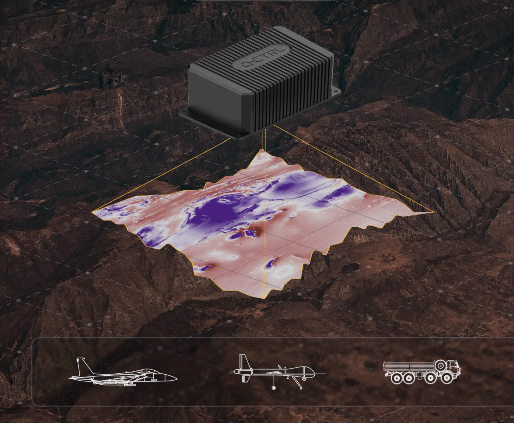
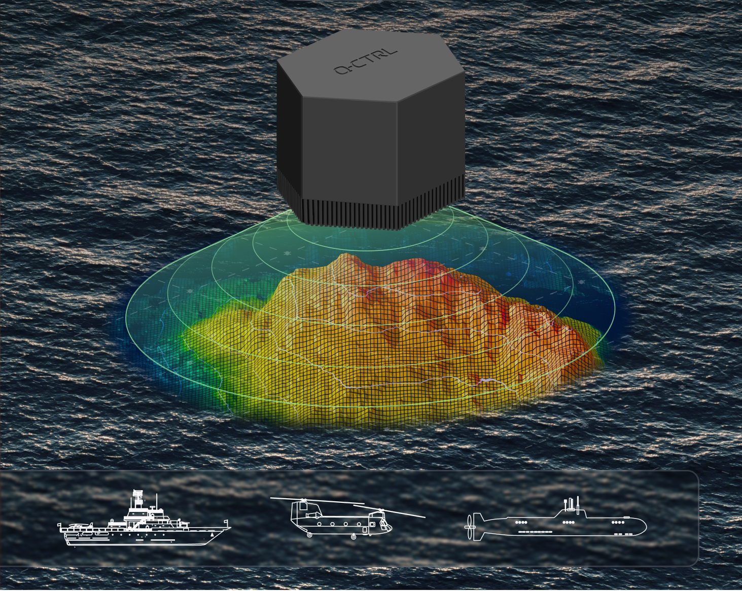
    Ironstone Opal leverages quantum sensors – stabilized using software – to provide navigation immune to the kinds of interference plaguing commercial aviation, shipping and defense operations.

    In airborne trials, Ironstone Opal enabled GPS-free navigation with an accuracy up to 111 times better than the best conventional GPS alternative, even under highly dynamic maneuvers. It delivered GPS-like positioning accuracy down to just 4 meters over flights up to 700 kilometers long.

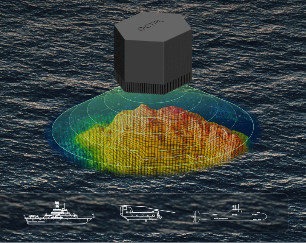
    Most recently, Ironstone Opal operated continuously for more than 144 hours on an Australian Navy vessel, the MV Sycamore, trialling gravimetric navigation capabilities. 

    “In today’s sophisticated threat environment — marked by jamming, GPS denial, and spoofing — quantum sensing offers a strategic advantage delivering resilient and precise capabilities where traditional systems fall short,” said Jonathan Green, Chief Technology Officer, Northrop Grumman Mission Systems. “As a leader in quantum technology, Northrop Grumman supports innovators like Q-CTRL in advancing the quantum industry to enhance national security through cutting edge innovation.”

    Each year, TIME recognizes 300 products, software and services that are changing the world, including scientific or technological breakthroughs and innovations that make life easier and more sustainable. Ironstone Opal was identified through research from TIME’s global network of reporters and expert contributors based on key evaluation factors like originality, efficacy, ambition and impact.

    The Key to Ironstone Opal

    Ironstone Opal’s quantum sensors detect tiny, otherwise imperceptible signals from Earth’s structure that serve as gravimetric or magnetic “landmarks” for navigation, which are then compared with geophysical maps for precise positioning. Q-CTRL’s proprietary software-ruggedization hardens these quantum sensors for operation in the real world, allowing resilient performance in demanding environments.

    The system can function as a robust backup for GPS on both crewed and uncrewed defense platforms, as well as in commercial settings. More than 1,000 commercial flights per day are affected by GPS denial, and many key players in the aerospace industry, including Airbus, are looking into quantum-assured navigation technologies as a solution.

    TIME’s recognition of Ironstone Opal follows August’s news that DARPA awarded Q-CTRL two contracts totalling $24.4 million USD to develop quantum sensors for navigation on defense platforms. Also, in March, the Department of Defense’s Innovation Unit (DIU) awarded a contract to Lockheed Martin and Q-CTRL to develop a quantum-enabled inertial navigation system.

  • Q-CTRL, Lockheed to Develop Quantum Navigation for DARPA

    Q-CTRL, Lockheed to Develop Quantum Navigation for DARPA

    DARPA selects Q-CTRL to develop next-gen sensors for advanced defense platforms.

    Quantum software company Q-CTRL has been awarded two contracts under DARPA’s Robust Quantum Sensors (RoQS) program. The Defense Advanced Research Projects Agency (DARPA) is an independent research and development agency within the U.S. Department of Defense.

    The contracts, valued at $24.4 million, will augment Q-CTRL’s field-validated quantum sensing technologies for demanding real-world use cases in high-performance military vehicles. 

    Navigational technology that is resilient to denial, jamming, spoofing and other denials in the environment has become increasingly critical to defense applications, from battlefield operations to intelligence and surveillance. With conflict zones expanding, the risks to crewed and uncrewed defense missions are growing daily. Quantum sensing offers a complementary solution to  GPS that is resilient against external interference while filling coverage gaps.

    Quantum sensing offers a complementary solution to  GPS that is resilient against external interference while filling coverage gaps.

    Q-CTRL will develop next-generation quantum sensors for navigation based on their success in field trials of airborne, maritime, and ground-based quantum navigation augmented by their proprietary AI-powered software ruggedization. The technology enables sensors to operate reliably on moving defense platforms subject to challenging real-world conditions, without the need for traditional shielding or isolation.

    Q-CTRL will be joined by Lockheed Martin as a subcontractor on one aspect of the RoQS program, leveraging its expertise in GPS and quantum technology.

    Photo:
    Software-ruggedized quantum magnetometer. (Image: Q-CTRL)

    DARPA established RoQS to accelerate the development, testing and validation of quantum sensors for real-world defense applications, which include maintaining stability against environmental interference, mechanical vibrations and heavy g-forces. 

    Some sectors and organizations are fast-maturing quantum navigation for use on land, sea, in space, and in the air. The aerospace industry is actively exploring the potential for magnetic navigation technologies, with companies like aircraft manufacturer Airbus pursuing their development. 

    Additionally, Q-CTRL’s programs target the complementary missions of geophysical mapping of gravity and magnetic fields, as well as positioning based on matching detected signals to the pre-generated maps. This approach provides huge advantages in navigational missions and delivers new insights into minerals prospecting and underground target detection.

    Photo:
    Software-ruggedized quantum gravimeter. (Image: Q-CTRL)

    Ironstone Opal, the company’s quantum-assured navigation system, recently outperformed a high-end inertial navigation system (INS) in flight for the first time, achieving up to 111x greater positioning accuracy when GPS was unavailable – a significant step forward for real-world applications of quantum sensing to defense missions. In these tests, the company’s proprietary AI-driven, software-level innovation was the key to the removal of platform interference.

    Ironstone Opal’s navigation system was also recently validated in maritime trials on board the Royal Australian Naval vessel, MV Sycamore.

    In March, Lockheed Martin and Q-CTRL were awarded a contract by the U.S. Department of Defense’s Innovation Unit to prototype a quantum-enabled inertial navigation system.

  • Quantum magnetometer could solve GNSS-denied navigation problems

    Quantum magnetometer could solve GNSS-denied navigation problems

    Fraunhofer IAF presented the latest version of its compact integrated quantum magnetometer at World of Quantum in Munich. The diamond-based system is characterized by its robustness, high integration density, and measurement sensitivity. It offers new measurement possibilities for a wide range of applications, including navigation.

    The highly integrated vector magnetometer developed by the Fraunhofer Institute for Applied Solid State Physics IAF is based on nitrogen vacancies (NV) in diamond and provides access to the smallest magnetic fields with a previously unattainable degree of flexibility and precision. The miniaturized measuring system offers new possibilities in applications that require precise measurement with minimal interference, such as in biochemical measurements of nerve pathways or in microelectronics.

    “What makes the diamond-based NV vector magnetometer so special is its native and intuitive functionality, which enables it to precisely measure the vector components of the Earth’s magnetic field under most operating conditions,” explained Michael Stoebe, Business Unit Manager for Quantum Devices at Fraunhofer IAF. “This makes the sensor not only a technical innovation, but also a significant advance in sensor technology,”

    The unique properties of the NV center on the diamond lattice, which is arranged along the four crystal axes, enable all vector components of the magnetic field to be detected with a single sensor chip using <100> diamond. This reduces the calibration effort and opens up new possibilities for applications that were previously limited by the restrictions of conventional magnetometers. This sensor represents a significant step toward more precise and efficient measurement techniques, according to Fraunhofer.

    Safe navigation without GNSS

    Despite their high precision and coverage, today’s navigation systems are often prone to interference and are not available everywhere. Alternative navigation methods that function independently of GNSS are therefore gaining in importance. The Earth’s magnetic field is a promising basis for this, as it exhibits regional differences that can be used as an invisible map for autonomous navigation, especially in areas where GNSS signals are disrupted or difficult to receive.

    The quantum sensor developed at Fraunhofer IAF makes it possible to create comprehensive magnetic field maps and provide reliable navigation based on them. The vector magnetometer offers an autonomous, interference-free method for global positioning and navigation. It complements satellite-based navigation and also works without satellite signals, for example underwater, in canyons, underground, in buildings, or in tunnels.

    Increased integration density and sensitivity

    Researchers at Fraunhofer IAF have succeeded in reducing the size of their integrated quantum magnetometer by a factor of 30 in just one year. The sensor head now has a compact size comparable to conventional and industrially used optically pumped gas cell magnetometers (OPMs) with high sensitivity in the picotesla range. The diamond-based system stands out from competing technologies thanks to its high robustness and wide measuring range, which allows it to be used flexibly in a wide variety of measurement scenarios with extremely low calibration requirements.

    “We are striving for even greater integration density, while increasing sensitivity. Our goal for the coming year is to reduce the size of the sensor by a factor of 5 again, while further increasing sensitivity to enable measurements in the sub-picotesla range,” emphasizes Dr. Michael Stoebe.

    The special feature of the integrated quantum magnetometers developed by Fraunhofer IAF is their optional water cooling, which ensures robust and reliable measurement of magnetic fields even under the difficult operating conditions. This flexibility in design and integration is what sets the latest sensor prototypes from the Freiburg-based institute apart.

    “We take an application-oriented approach to the continuous development of our sensor systems and respond to the individual requirements placed on our systems,” said Michael Kunzer, project manager at Fraunhofer IAF.

    In addition to further developing the system, the core element of the sensor — its nitrogen-vacancy (NV)-doped diamond sensor head — is also being improved at Fraunhofer IAF. The synthetic diamond is grown at the institute in special reactors and further processed into quantum devices through the controlled exchange of carbon atoms with nitrogen atoms. The wafer sizes of the ultra-pure diamond are to be further developed next year from the current two inches to industrially scalable four-inch wafers.

    Geological measurements quickly and contact-free

    The quantum magnetometer developed by Fraunhofer IAF enables precise, contact-free localization of underground mineral deposits, thereby providing access to valuable resources. It can also detect unexploded ordnance over large areas, significantly reducing the risk to people in affected areas. Using the same principle as in navigation, the composition of the Earth’s crust and its magnetic field can be used to draw conclusions about geological formations. Magnetic anomalies such as ore deposits or metallic objects such as unexploded ordnance can thus be detected.

    The collected data can be converted into magnetic maps that show the locations of suspicious objects and provide information about their depth, shape, and size. This method enables comprehensive and non-invasive exploration of affected areas and the location of even deep-lying objects.

    World of Quantum 2025

    At the World of Quantum 2025 June 24-27 in Munich, Fraunhofer IAF presentsthe latest prototype of its NV vector magnetometer n Hall A1, Booth 439-3, on the Quantum Future Boulevard.

  • Quantum magnetometer senses its place

    Quantum magnetometer senses its place

    Scientists continue to search for new technologies to serve the PNT mission. One novel way to augment GPS comes from a newly developed technology involving a quantum magnetometer.

    Researchers at Lockheed Martin call it Dark Ice; it uses magnetic sensing as an alternative means of determining location without use of satellite signals.

    Mike DiMario and his team have developed a prototype magnetometer that uses a synthetic diamond the size of a salt crystal to measure the direction and strength of nearly imperceptible magnetic field anomalies. They overlay that data with maps of Earth’s magnetic field, supplied by the National Oceanic and Atmospheric Association, to produce precise location information.

    Special quantum-level impurities in the molecular structure of the diamond, where intermittently a carbon atom drops out and its neighbor is a nitrogen atom, enable the detection of magnetic field waves. These nitrogen vacancy (NV) centers are hyper-sensitive magnetic sensors. When illuminated by a laser, the diamond emits more or less light depending on the surrounding magnetic field’s strength.

    The Dark Ice quantum magnetometer measures about 31 centimeters in length. (Image: Lockheed Martin)
    The Dark Ice quantum magnetometer measures about 31 centimeters in length. (Image: Lockheed Martin)

    Position + Direction. Dark Ice differs from current magnetic sensors aboard ships and planes in that it can measure both the field strength and the direction the field is pointing. “The real advantage of this quantum-based technology is its ability to produce a true magnetic field vector, while at the same time having a very large dynamic range and bandwidth,” DiMario explained.

    Project development “was like peeling an onion: with each new layer removed, the team advanced. We had no idea of the expected outcome, other than what system modeling, the laws of physics and good engineering could predict. There was always something we could not have predicted or even thought of.”

    In addition to developing this navigational capability, the team has also demonstrated that Dark Ice can harness Earth’s magnetic field to transmit communications across barriers intended to block all traditional signals, and track moving vehicles in real time.

    Unjammable. “This project was designed for times when extenuating circumstances might prohibit your use of traditional GPS signals, and you need something that is unjammable, passive and always available. The Earth’s magnetic field meets this description if we can adequately sense and make use of it,” DiMario said.

    He wants to downsize Dark Ice to hockey-puck size for convenient use on multiple platforms. “In real-world conditions, if I can get within 200 meters of GPS accuracy, that would be a huge success,” he claimed. Such precision would serve as a backup or verification to GPS, not a sole-means navigation system.

    With its powerful sensing capabilities and small size, Dark Ice could function as the most reliable way to do things like identify hard-to-find watercraft in search-and-rescue missions and fly aboard aircraft in the battlefield. Navigation, search and communications — all in one compact sensor.

    Earth’s magnetic fields. (Image: Lockheed Martin)
    Earth’s magnetic fields. (Image: Lockheed Martin)