Tag: railway

  • Dual-band GNSS antenna ready for railways

    Dual-band GNSS antenna ready for railways

    Image: 3alexd/E+/Getty Images
    Image: 3alexd/E+/Getty Images

    Huber+Suhner extends its Sencity rail MIMO antenna portfolio with dual-band GNSS services

    Huber+Suhner, an international manufacturer of components and systems for optical and electrical connectivity solutions, has extended the capabilities of its rail rooftop antennas with its launch of an embedded dual-band GNSS antenna that meets the railway industries’ stringent requirements.

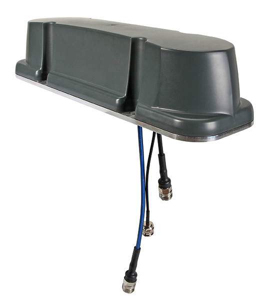
    Adding to its established Sencity rail antenna portfolio, the new multiple-input, multiple-output (MIMO) rooftop antenna enables railway operators to improve geospatial positioning and time precision of their operations.

    Photo: Huber+Suhner
    Photo: Huber+Suhner

    Supporting both the upper and lower GNSS bands, the antenna enables pinpoint location accuracy for the rigorous applications such as autonomous trains. With greater transparency of movement on the tracks, railway operators can improve the operational planning of densely crowded railway tracks and metro lines.

    “The GNSS port on the antenna supports a higher number of satellite constellations,” said Daniel Montagnese, Huber+Suhner product manager for railway antennas. “This enables operators to improve signal acquisition time, as well as reducing the impact of obstructions in order to increase efficiency on the tracks.”

    The GNSS port is complemented by two broadband cellular and Wi-Fi compatible ports that can be deployed for a variety of different train-to-ground services.

    The Sencity MIMO rail antenna supports the GPS, Galileo, BeiDou and GLONASS constellations. Its robust design also meets the stringent EN 50155 railway standard and is fire retardant according to EN 45545-2 and NFPA130.

    Huber+Suhner is a global company with headquarters in Switzerland which develops and manufactures components and system solutions for electrical and optical connectivity. With cables, connectors and systems — developed from the three core technologies of radio frequency, fiber optics and low frequency — the company serves customers in the communication, transportation and industrial sectors.

  • Estonian Railways selects Hexagon to automate and digitize operations

    Estonian Railways selects Hexagon to automate and digitize operations

    Railway solutions power asset management and infrastructure maintenance

    Estonian Railways Ltd., a state-owned company responsible for Estonia’s railway administration, has selected Hexagon’s Geospatial division to implement a transportation system that will automate and digitize the railway’s infrastructure maintenance, construction and traffic management processes.

    The combined asset management system and geographic information system (GIS) platform will help the company’s 700-plus employees efficiently manage assets and workflows.

    Powered by Hexagon’s GeoTrAMS, a web-based system for tram and light-rail infrastructure, and GeoMedia, a flexible GIS management platform, Estonia Railway will be able to visualize assets on a map while integrating with other companies and external systems.

    Hexagon’s state-of-the-art registry will serve multiple information systems and users at the same time, centralizing the use of asset and spatial data while avoiding data duplication and ensuring that users have access to the most up-to-date information.

    “As a company, we are in a unique situation of simultaneously implementing Hexagon-specific spatial data modules for rail infrastructure management and Microsoft’s ERP for asset management, gathering and digitizing different fragmented data, unifying different workflows and applying new data management principles,” said Maia Sokk, innovation manager at Estonian Railways. “Based on our strategic goals for the next four years, we are significantly modernizing our traffic management systems. Implementing Hexagon’s technologies is an important link in this ambitious plan.”

    Prior to selecting Hexagon, Estonian Railways used a fragmented system of disparate software applications to manage assets and infrastructure across its 750 miles of railroad, 129 platforms and 60 stations. With the new solution in place, Estonia Railway will be able to improve operational efficiency and transparency, better control expenses connected to the infrastructure and streamline administrative tasks.

    “Estonian Railways is forward-thinking in its use of location intelligence for managing infrastructure and operations,” said Mladen Stojic, president of Hexagon’s Geospatial division. “We are excited to deliver an integrated solution that will help the railway effectively monitor and maintain its assets while also ensuring successful management of rail traffic, construction projects and services.”

    Estonian Railways has been responsible for ensuring the smooth operation, management and maintenance of the country’s railway infrastructure since 1870.

    Learn more about how Hexagon helps organizations close the gap between the geospatial and operational worlds with its transportation solutions.

    Photo: joyt / iStock / Getty Images Plus / Getty Images
    Photo: joyt /iStock / Getty Images Plus/ Getty Images
  • Railway in France to test GNSS for train control

    A region in France is working with SNCF (the French National Railway Company) to foster the emergence of new solutions — including GNSS technologies — for the operation and control of regional trains and railway infrastructure.

    On Sept. 1, the Occitanie/Pyrénées-Méditerranée Region and GUIDE (GNSS Testing Laboratory) signed an agreement to open a railway line to field tests for companies seeking to perform assessments aboard trains. The agreement is supported by the French space agency CNES and the Aerospace Valley Center.

    The Geofer project, managed by GUIDE, will allow the testing of applications in operational situations. The applications are based on radionavigation and telecommunication data initially intended for other business sectors.

    Through the Geofer project, the Occitanie/Pyrénées-Méditerranée Region is pursuing two strategic goals. The first aims to strengthen mobility within the region through better control of operating costs. The second is to diversify industrial activities with rail. The project could lead to modernization of secondary lines of the national railway network by embedding, for example, some functions of railway signaling.

    The test region — the Tessonnières-Rodez line (Tarn/Aveyron) — crosses a mountainous area conducive to tests in constrained environments.

    As leader of the project, GUIDE is working to geo-reference the line and to instrument a train that will calibrate future embedded applications. The collected data will then be re-used and replayed on test benches to help solution developers tune their embedded systems more easily.

    A co-financer of Geofer, CNES is actively involved in the tests. A receiver implementing an algorithm (PPP-WIZARD) developed by its engineers will be tested on board, using software to exploit future satellite services to achieve decimetric accuracy. This technology could make possible many rail applications such as precise dock stops or a better prediction of maintenance operations.

    M3 Systems will supply the mission receiver responsible for dispatching accurate and real-time data about the positioning and speed of the train to embedded applications. This device merges the satellite measurements with those of other sensors used to ensure the quality of the geolocation messages.

    For example, devices such as shock sensors to detect unusual efforts of the pantograph against the overhead cable, speed control systems for eco-driving, and roaming systems for telecommunication will be developed, implemented and evaluated on the line and on simulation benches.