Tag: Reach RS2

  • Emlid offers two PPK modules for cm-accurate drone mapping

    Emlid offers two PPK modules for cm-accurate drone mapping

    Reach M+ and M2. (Photo: Emlid)
    Reach M+ and M2. (Photo: Emlid)

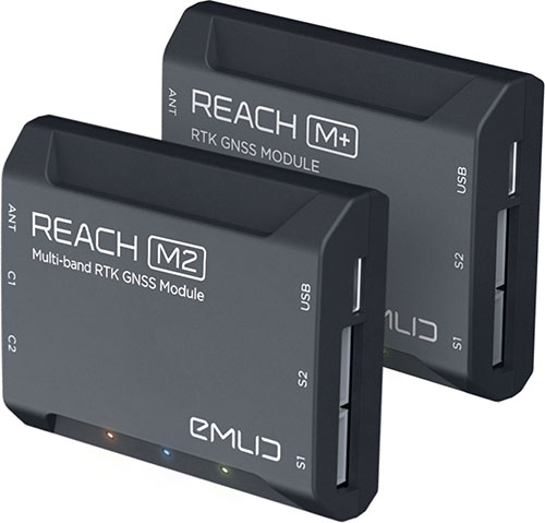
    Emlid is offering two positioning modules for mapping with unmanned aerial vehicles (UAVs). Both the Reach M+ and Reach M2 provide centimeter-level accuracy in real-time kinematic (RTK) and post-processed kinematic (PPK) modes, enabling precise UAV mapping with fewer ground control points.

    The Reach M+ single-band receiver has a baseline up to 20 kilometers in PPK. The Reach M2 is a multi-band receiver with a baseline up to 100 kilometers in PPK.

    Usually autopilot triggers the camera and records the coordinate it has at that moment. When the drone is flying at 20 m/s and GPS works at 5 Hz, the UAV autopilot will have position readings only every four minutes, which is not suitable for precise georeferencing. In addition, there is always a delay between the trigger and the actual moment the photo is taken.

    Reach solves this problem by connecting directly to the camera’s hot-shoe port, which is synced with the shutter. The time and coordinates of each photo are logged with a resolution of less than a microsecond. Reach captures flash sync pulses with sub-microsecond resolution and stores them in a raw data RINEX log in the internal memory. This method allows ground control points to be used only to check accuracy.

    The Reach RS2. (Photo: Emlid)
    The Reach RS2. (Photo: Emlid)

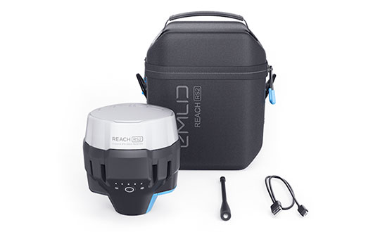
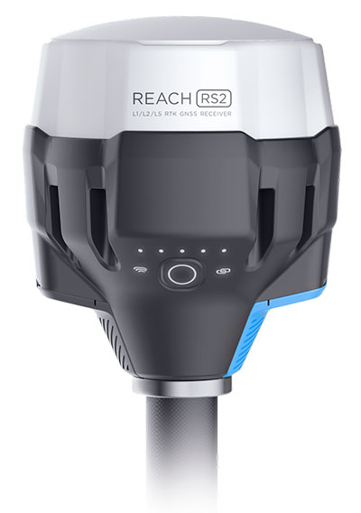
    The Reach M2 PPK UAV mapping kit consist of the Reach M2 multi-band GNSS receiver onboard the aircraft that records the location of each photo at a frequency of 20 Hz. It is combined with the Reach RS2 GNSS multi-band receiver on the ground, drastically reducing the number of ground control points and simplifying the setup process on site, while maximizing the accuracy to centimeter levels even in remote areas.

    The M2 tracks GPS/QZSS (L1, L2), GLONASS (L1, L2), BeiDou (B1, B2), Galileo (E1, E5) and SBAS (L1C/A), and receives a fixed solution almost instantly.

  • Emlid launches Reach RS2 multi-band RTK receiver

    Emlid launches Reach RS2 multi-band RTK receiver

    Photo: Emlid
    Photo: Emlid

    Emlid has debuted the Reach RS2, a fully-featured multi-band RTK receiver. All of its features are available out of the box, along with a survey app for iOS and Android.

    The Reach RS2 tracks L1/L2 bands on GPS, GLONASS and BeiDou, and L1/L5 on Galileo, and acquires a fixed solution in seconds. It achieves centimeter-level precision for surveying, mapping and navigation and maintains robust performance even in challenging conditions. Centimeter accuracy can be achieved on distances up to 60 km in RTK and 100 km in PPK mode.

    Up to 22 hours of autonomous work when logging data and up to 16 hours as a 3G rover, even in cold weather—no more need to carry spare batteries with you. Reach RS2 can charge from a USB wall charger or a power bank over USB-C.

    Reach RS2 comes with a free app for iOS and Android called ReachView, which supports thousands of coordinate systems worldwide. With ReachView, users can fully configure their Reach receiver, enable RINEX data logging, and survey in RTK.

    Reach RS2 also features a power-efficient 3.5G HSPA modem with 2G fallback and global coverage. Corrections can be accessed or broadcast over NTRIP independently, without relying on an internet connection on a smartphone.

    Base for RTK Drone. The Reach RS2 can be used as a base station for drone mapping, using an RTK drone such as the DJI Phantom 4.

    A new service offered by Emlid is Emlid Caster, a free way to pass corrections between receivers over the internet. Emlid Caster works with any NTRIP-capable device.

    E38 Survey Solutions, an Emlid dealer in the United States, conducted a case study with the Reach RS2.

  • Emlid launches Reach RS2 centimeter-accurate RTK GNSS receiver

    Emlid launches Reach RS2 centimeter-accurate RTK GNSS receiver

    Emlid, the creators of Reach, centimeter-accurate RTK GNSS receiver, is now taking pre-orders for its multi-band GNSS receiver Reach RS2. The new receiver features a built-in LoRa radio, a 3.5G modem, and a survey app for iOS and Android.

    Photo: Emlid
    Photo: Emlid

    L1/L2/L5 RTK GNSS receiver with centimeter precision. Reach RS2 determines a fixed solution in seconds and provides positional accuracy down to several millimeters. The receiver tracks GPS/QZSS (L1, L2), GLONASS (L1, L2), BeiDou (B1, B2), Galileo (E1, E5) and SBAS (L1C/A), and reliably works in RTK mode on distances up to 60 kilometers and 100 kilometers in PPK mode. A multi-feed antenna with multipath rejection offers robust performance even in challenging conditions.

    RINEX raw data logs are compatible with OPUS, CSRS-PPP, AUSPOS and other PPP services so users can now get centimeter-precise results any place on Earth.

    Built-in 3.5G modem and UHF LoRa radio. The Reach RS2 features a power-efficient 3.5G HSPA modem with 2G fallback and global coverage. The corrections can be accessed or broadcast over NTRIP independently, without relying on internet connection on a smartphone.

    For remote areas, the Reach RS2 has a built-in LoRa radio that has proven to be a reliable link for RTK corrections for distances up to 8 kilometers.

    Designed for Tough Conditions. The Reach RS2 is engineered to be waterproof and impact-resistant. Its body is manufactured in a two-step injection process and is made out of shockproof polycarbonate covered in a special elastomer for extra protection. The receiver has an industry-standard 5/8-inch mounting thread.

    The LiFePO4 battery of the Reach RS2 is designed for 16 hours of work as a 3.5-G RTK rover on one charge regardless of weather conditions. It can charge from a USB wall charger or a power bank over USB-C.

    A RS232 interface allows users to connect the Reach RS2 directly to external hardware and output position in NMEA.

    Photo: Emlid
    Photo: Emlid

    ReachView App. The Reach RS2 comes with a mobile app, ReachView for iOS and Android, that is used to control all the features of the device. Users can create projects, collect and stake-out points, and import and export geodata in industry-standard formats such as CSV, DXF and Esri Shapefile.

    The Reach RS2 comes in a carrying bag with a USB-C cable and a LoRa radio antenna. The ReachView app is available for download from Play Market or App Store.

    Shipping of the first batch starts in mid-June 2019.

    See the full specs and pre-order Reach RS2 on Emlid website.