U-blox is collaborating with LynQ, which developed a location tracker that doesn’t use cellphones, networks, apps or monthly fees. By syncing up the devices before heading out, group members can find each other within a five-mile radius and link up again.
LynQ surpassed its fundraising target on the Indiegogo crowdfunding platform, raising more than $1.5 million, and is now on pre-sale.
The device uses the u-blox CAM-M8Q GNSS receiver, a GPS/GLONASS/BeiDou positioning module with an embedded antenna. With its slim size of 9.6 x 14 x 1.95 millimeters, it is easy to integrate it into handheld devices, u-blox said.
The first generation of the weather-proof tracker uses long-range, low-power radio frequencies to connect devices. Up to 12 people can join a group, split up, and use the only button on the clip-on device to toggle through the group members and find out in which direction and how far away each one is.
LynQ’s crowdfunding success shows the extent to which the company’s founders uncovered an unmet demand on the market. While smartphone-based solutions to locate friends and family, for instance in a crowd, abound, they are limited by the availability of mobile network reception.
LynQ’s location tracker helps friends regroup outdoors or at crowded events, parents keep an eye on their children, and caregivers watch over the safety of people with special needs, elderly family members, or loved ones suffering from diseases such as Alzheimer’s.
The tracker has been field-tested on numerous continents and in most topographies and use cases.
“We found the u blox CAM-M8Q to be the best solution for us to achieve the requirements our use cases demand,” said Drew Lauter, COO at LynQ. “We’re extremely price sensitive, yet we need a highly dependable GPS module; u-blox worked closely with us to deliver that.”
For u blox, accompanying LynQ in the development of its product has been an exciting adventure, said Suresh Ram, president of u-blox America. “We’re thrilled to see how well their idea has been received by the public and look forward to our continued collaboration in the future.”
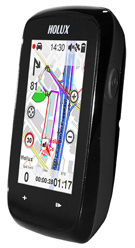
The Holux SporTrek 1305 for avid cyclists features a u-blox positioning module. Photo: Holux
Holux Technology, a maker of professional and consumer GPS products, has launched its next-generation bike computer, the SporTrek 1305, which integrates a u-blox MAX GPS/GNSS module. The new device delivers GPS and wireless health-monitoring features on a compact, three-inch color touchscreen display.
The device delivers a variety of useful information such as speed, heart rate, distance, altitude, map, and route, and comes with a calendar and stopwatch. SporTrek 1305 is the designed for touring, competitive cycling and mountain biking.
The device integrates a compact u-blox MAX GPS/GNSS module that supports GPS as well as GLONASS, QZSS and all SBAS. The module is targeted at applications requiring small size, low power, fast acquisition, and reliable operation in GPS hostile environments.
“Since 1994, Holux has been manufacturing a wide range of battery-operated GPS products for sports, automotive and safety devices. We count on extremely fast, low-power and accurate global positioning technology to deliver the features our customers demand,” said Eddy Huang, director, Marketing & Sales at Holux. “u-blox’ advanced satellite positioning module provides us with the performance, small size, and low power consumption that we need in a consistent, future-proofed form factor.”
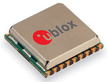
u-blox MAX GPS/GNSS module. Photo: Holux
The SportTrek 1305 is shock and water resistant able to operate in all weather conditions. Equipped with Bluetooth Smart for accessories (such as heart-rate straps), it can also connect to heart-rate monitor / combo (speed and cadence) sensors and smartphone connection and notification, providing navigation and performance training data.
It also integrates a patented “carbon reduction” feature that informs the user about the amount of equivalent carbon emissions saved compared to driving, and converts the data into the corresponding number of trees planted to achieve the same effect.
SporTrek 1305 can be integrated with ezTour Plus software to share track route and analysis of physical states, and it can also be used to plan routes using the ezTour Planner feature. Users can integrate their own paper maps and third-party application as well.
Three additional companies — Qualcomm, Red Bend and QuickPlay — have signed on to work with the connected car industry at the AT&T Drive Studio, a connected car center for innovation and research in Atlanta, Georgia.
“This is an exciting ecosystem and we are committed to leading the way to take the connected car to the next level for auto manufacturers and their drivers,” said Glenn Lurie, president, AT&T Emerging Enterprises and Partnerships, AT&T Mobility. “That’s the essence of the AT&T Drive Studio, to bring together the best players in the auto industry ecosystem to collaborate and create the future faster.”
The AT&T Drive Studio will now include support from the following companies:
Qualcomm Technologies, Inc., intends to showcase its newly announced Qualcomm Snapdragon Automotive Solutions for infotainment and telematics at the AT&T Drive Studio. Qualcomm Technologies plans to integrate these solutions with AT&T’s Drive portfolio, including AT&T’s global SIM, bifurcated billing, voice recognition, and the nation’s most reliable 4G LTE network.
AT&T has selected Red Bend Software to be a solution provider to remotely manage automotive software in the new AT&T Drive Studio. Hosted in the AT&T cloud, the Red Bend Software Management Center is an OMA-DM standard-based platform designed for car manufacturers to manage in-vehicle software and applications over the air with reliability and efficiency. Red Bend’s comprehensive software management platform significantly reduces the time and cost for automotive OEMs to manage the lifecycle of all in-vehicle software, from head units to map content and ECUs.
AT&T has selected QuickPlay Media to develop an in-vehicle video service. The offering will be powered by QuickPlay’s OpenVideo platform and will deliver Live Linear TV and streaming video on demand services to automotive manufacturers collaborating in the AT&T Drive Studio. QuickPlay’s solution will enable AT&T to provide in-car “infotainment” by delivering secure streaming of hundreds of live linear TV channels and hours of premium VoD content. The solution includes a configurable, customizable client application, support for adaptive streaming, complete content protection with DRM solutions like Microsoft PlayReady, user entitlements, dynamic advertising, banner ad support, multi-language support and featured content.
Opened in January 2014, the AT&T Drive Studio is a dedicated facility for connected car innovation and research. Located in Atlanta, the more than 5,000-square foot AT&T Drive Studio features working garage bays, a speech lab, and a full showroom to exhibit the latest innovations. The AT&T Drive Studio integrates AT&T solutions across multiple companies and serves as a hub where AT&T can respond to needs of automotive manufacturers and the auto ecosystem at large.
Boatracs, Kannad, McMurdo and TSi have combined to form McMurdo Group, a single-vendor provider of end-to-end search and rescue, maritime domain awareness solutions.
McMurdo Group has announced a suite of Automatic Identification System (AIS) survival solutions for enhanced collision avoidance and man overboard (MOB) response in the U.S. recreational boating market. The offerings include AIS beacons, transponders, receivers and software.
AIS is an automatic tracking system used on boats and ships that identifies and tracks nearby AIS-equipped vessels and devices to help avoid collisions. AIS transponders send and receive critical navigation information – such as vessel identification numbers, vessel type, position, course and speed – and graphically display a map of the surrounding vessels and area. AIS receivers are often used in conjunction with AIS-capable computer software for similar tracking and monitoring purposes.
In the event a person with an AIS MOB beacon falls overboard, an AIS signal from the beacon is activated. This signal is then sent to AIS receiving devices where the location of the individual in the water can be pinpointed using GPS positioning and presented on graphical chart maps.
The Smartfind M5 has an on-screen beacon location indicator and audible alarm that is triggered to accelerate rescue efforts. It also has a “buddy list” feature that can identify the specific individual needing MOB assistance. For larger fleets, the McMurdo Group AIS Alarm Notification System extends graphical mapping, alarm notification and messaging capabilities to shoreside fleet management operators.
The McMurdo Group AIS product suite includes the following:
AIS Search and Rescue Transponders (SART) or Beacons
Smartfind S5 – a compact, lightweight, waterproof (to 10 meters) AIS SART with high-visibility buoyant carry-off bag ideal for use on life rafts or survival crafts.
Smartfind S10 – a personal, waterproof (to 60 meters) AIS Man Overboard (MOB) device with built-in flashing light and used by individuals or as an additional device to complement a yacht’s on-board flare pack.
Smartfind S20 – a compact AIS MOB device with integrated light for use in a lifejacket.
AIS Transponders and Receivers
Smartfind M5 AIS Class A Transponder – the industry’s first AIS Class A transponder with color display and AIS MOB and AIS SART alarm with crew list functionality to aid in MOB recovery.
Smartfind M10 AIS Class B Transponder – typically used for smaller vessels, charter boat operators or where the additional features of an AIS Class A transponder are not required (includes an a 30 day data logger).
Smartfind M15 AIS Receiver – economical AIS receiver for all recreational vessels.
AIS Software
PC Viewer – Graphical software package ideal for individual vessel operators (included with the Smartfind M5, M10 and Smartfind M15 products).
AIS Alarm Notification System – Vessel Monitoring System with integrated AIS MOB Alerts and Messaging typically used for ship-to-shore communications.
Rand McNally today introduced the RVND 7720, a 7-inch RV GPS device with Wi-Fi connectivity allowing for real-time weather information and display, and new hardware with rugged casing, video input, and brighter screen.
The new device — shipping now to stores, online retailers, and RV dealers and distributors — joins Rand McNally’s line of RVND GPS devices for RVers. Rand McNally pioneered RV-specific navigation by launching the first GPS device designed specifically for RVers and campers, the company said.
RV-specific navigation is necessary to route large vehicles and towables around road restrictions, low bridges and other physical hazards. However, like all Rand McNally RV GPS devices, the RVND 7720 can be used as a car GPS by changing a simple setting.
One of the key new features of the RVND 7720 is Wi-Fi connectivity, which enables the transmission and display of weather as well as other real-time information. With updated weather information, RVers will be able to anticipate delays and make plans by viewing current and predicted conditions displayed on the map and along the route, the company said. Besides weather, other RV-specific connected services will be coming soon for this device.
The RVND 7720 has a new hardware platform as well, with a rugged design with ridged casing for added protection, a brighter screen that adjusts for low and strong light, and video input compatible with a range of back-up and rear-view cameras, Rand McNally said.
The base maps and overlaying content, such as campgrounds, parks, RV service and other RV points of interest, also have been updated for the RVND 7720.
The new device ships with Lifetime Maps, so owners will be able to update their devices at no additional cost.
The RVND 7720 GPS includes the following additional new features:
Fully updated road data, including RV-specific information such as speed limits, legal and physical restrictions, and all Rand McNally proprietary RV data
Fully updated points of interest necessary for safe and convenient routing, including travel centers and RV parking information at rest stops, exits, and other locations
Fuel logs, which are accessible from the Virtual Dashboard or via RV Tools; the feature enables drivers to record fuel purchases for a trip
Additional routing options such as “Avoid State or Province” and “Avoid Smaller Roads”
Address book icon enhancement, which enables unique icons to be created by group and shown on the map for imported locations; address book items can be sorted by name, distance from current location or date added
Text-to-speech alert details for user-imported custom points of interest, such as red light cameras, to reduce driver distraction
The RVND 7720 also has these features: Virtual Dashboard; junction view with lane assist; free downloads of Rand McNally’s proprietary construction information and software updates; Exits Quick View, which shows RV parking and amenities at exits; RV Tools, RV amenities and locations such as campgrounds, RV services, and dumps; Woodall’s Campground information with searchable amenities; Rand McNally exclusive pre-planned trips with photos and video; and routing for 11 types of RVs as well as for cars.
Magellan is partnering with CCI Entertainment, a family programming production and distribution company in Canada. Their first initiative together, in partnership with Groundspeak, Inc. (owners of www.Geocaching.com), is a Canadian geocaching program called GeoFreakZ Geo Trails.
The GeoFreakZ GeoTrails program enables families visiting participating Parks Canada national parks and historic sites through October 13 to use a Magellan eXplorist GC handheld GPS device, designed exclusively for geocaching, to find hidden geocache containers. Rugged and waterproof with a sunlight-readable color screen, the eXplorist GC comes pre-loaded with a worldwide map and the most popular geocaches for a complete paperless geocaching experience, Magellan said. The Magellan eXplorist GC makes geocaching, an outdoor "treasure hunting" game with location-based technology, easy for families and people of all ages, the company said.
Participants who take photos of themselves discovering the caches are entered into a drawing to win a Magellan eXplorist GC device. Participants can also log their finds and communicate with other geocachers through Groundspeak's geocaching website, www.geocaching.com.
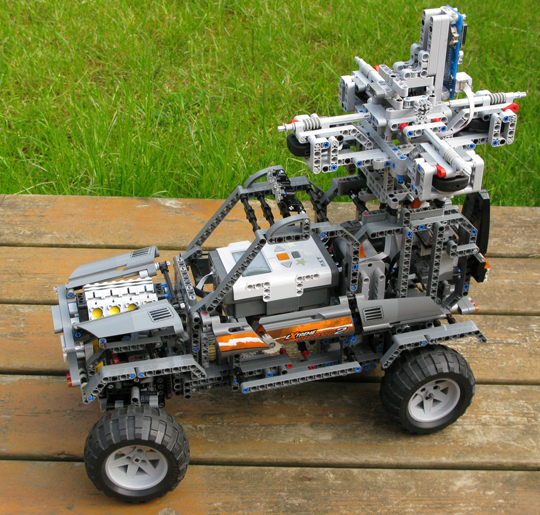
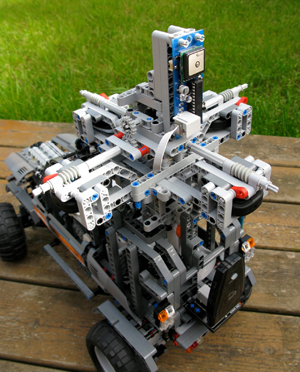
A Google Street Car in miniature uses Dexter Industries’ dGPS sensor (Photo courtesy of Mark Crosbie.)
Aspiring engineers, take note. A company dedicated to building robotic sensors for the LEGO Mindstorms NXT system has released a GPS sensor, and a workbook on how to use it.
John Cole, founder of Dexter Industries, explains that his products are intended for the education market, and are “for engineers, scientists, and those aspiring to be.”
“A few months ago, we developed a GPS sensor for the educational market, called the dGPS,” Cole said. The sensor is sold separately, as a third-party product for the LEGO Mindstorms kit.
The dGPS sensor provides GPS coordinate information to a robot and calculates navigation information. It provides latitude, longitude, time, speed, and heading. It also has powerful navigational calculators that can be used to navigate to target coordinates.
The dGPS sensor uses a Skytraq module. The LEGO NXT has limited computing capability and can’t interface directly with a GPS module, so Dexter Industries developed a micro-controller and software that translates and checks the signal from the GPS, and also performs additional calculations and functions for navigational purposes.
Photo courtesy of Mark Crosbie
“For example, in addition to the standard GPRMC string that comes from a GPS chip, our dGPS sensor can receive destination coordinates from the user and calculate distance to destination and angle to destination so they can be matched against a compass,” Cole said. “Also, because robots of this scale are usually traveling below 15 mph, we developed a more accurate compass function that works on the smaller, slower scale.”
The dGPS hooks directly into any of the four sensor ports on the NXT and can be programmed in NXT-G, RobotC, and LeJOS programming languages.
Cole became interested in the Mindstorms system in 2005 while in graduate school. “It’s an incredible robotics kit that really fits with educational curriculums on the high school and junior high levels. The kit lowers the entrance requirements to get started [in engineering], and because it’s based on LEGO, students are usually comfortable getting started with it. It’s deceptively simple, though; the Mindstorms robot can be used to do some pretty powerful stuff.”
Cole’s company had developed a few other sensors for education, including a solar kit and a pressure and temperature sensor, but focused on developing a GPS sensor, Cole said, because it “would be really fun for kids to start using. In particular, things like autonomous vehicles and mapping vehicles have been really exciting to develop and build with this sensor.”
Not Just for Kids. Mark Crosbie, an adult fan of LEGO (the hobbyists refer to themselves as AFOLs), has built a miniature version of the Google street car that roams the streets to photograph them for Google Maps. The car provides panoramic views from various positions along the streets it travels; data is then made accessible through the Street View feature of Google Maps.
Crosbie created his Street View car using Dexter Industries’ dGPS sensor to record coordinates as it drives along. “John has been very supportive of the project, providing great technical assistance to me as I used his sensor,” Crosbie said.
The idea for a miniature Google street car came to Crosbie when he was playing with the dGPS sensor. “I realized that if I combined this sensor with a robust chassis and a camera then I’d have a LEGO version of the famous Google Street View car. And what if I could then upload the pictures into Google Earth,” writes Crosbie on his website. “It all seemed so easy… How wrong I was!”
As Crosbie explains, his miniature Street View car is controlled manually using a PSPNx sensor to receive commands from any standard PSP game controller — the user presses the triangle button on the controller to capture an image and log the GPS coordinates. The cameras provided the biggest challenge. “The keyfob cameras are very temperamental and difficult to mount into standard LEGO dimensions,” he said.
“Every time an image is captured, the current latitude and longitude are recorded from the dGPS,” Crosbie explains. “The NXT creates a KML format file in the flash file system, which is then uploaded from the NXT to a PC. Opening the KML file in Google Earth shows the path that the car drove, and also has placemarks for every picture you took along the way. Click on the placemark to see the picture.”
Despite technical challenges outlined in his blog, Crosbie is undeterred, and working on another prototype. “I’m already hard at work on version 2.0 of the Street View car for a big event later this year.”
How-to Book. Besides hardware, Dexter Industries offers educational support material. “Just last week, we released a book that introduces middle school and high school students to GPS, and how to develop robots that use the GPS,” Cole said.
The book, Beginning GPS for NXT Robots, provides students with an introduction to the basics of GPS, and includes hands-on activities and tutorials on how to use the features of the dGPS sensor with the robots.
“This workbook was written to bring the GPS system to life and help students understand it, explore it, and find new ways to use it,” Cole said.
4-H program’s GPS/GIS program has started to use the company’s sensors in its curriculum, Cole said, because the sensors hook directly into the NXT robots.
The ION Mini-Urban Challenge, in which high school students compete to navigate a LEGO robotic car through a miniature city, don’t use GPS sensors. Students are provided with a kit that contains six other sensors that detect things such as light, color, and sound.
“We would love to be part of the ION challenge and we’ve tried contacting the organizers just recently,” Cole said. “It would be a great fit to get some students using the GPS in a way that really gets kids engaged in GPS/GIS development.”
A Google Street Car in miniature uses Dexter Industries’ dGPS sensor (Photo courtesy of Mark Crosbie.)A street-view photo captured from the on-board cameras of the mini car. (Photos courtesy of Mark Crosbie.)
GPS DATA maintains a 3D model that keeps a car correctly positioned while passengers hunt down werewolves.
Look out the window — is a werewolf hiding behind that tree?
Looking out the window while on a long car trip can be an adventure with a new GPS-based game being developed by The Interactive Institute in Stockholm, Sweden. The Backseat Playground uses GPS to turn passing sights like forests, buildings, and rivers into locations for in-game characters and events, reports New Scientist magazine. Backseat Playground consists of a GPS receiver, a handheld computer, and headphones — all connected to a laptop in the trunk of the car. A database of geographical information is used to match events in the game to suitable locations. Game characters and events are all generated dynamically during the car trip.
The game begins with a radio newsflash, relayed by the handheld computer, which places a passenger at the start of a murder mystery or a werewolf thriller. As the car travels along its route, the player receives further phone calls and messages from in-game characters.
Players interact mostly by listening; minimal graphics are involved, according to the designers. “It’s like a novel,” said John Bichard, who created Backseat Playground with colleagues Liselott Brunnberg and Oskar Juhlin. “We are trying to suggest spaces and places and events and have the user fill in the gaps to build a narrative.”
For now, a prototype now being evaluated only works over an area of 35 square kilometers in Stockholm. Initial feedback has been positive, and the team hopes to add voice recognition to the set-up. “Being able to talk directly to the characters would be great,” Bichard said.
We’ve always wondered what those werewolves had to say.