This week Sen. Patrick Leahy (D-Vt.), chair of the Senate Appropriations Committee, released that body’s version of nine different appropriations bills. The accompanying report for the bill to fund the Transportation Department (DOT) outlines the Senate’s intentions and way forward for establishing alternatives to GPS.
The report provides $15 million for the fiscal year that began on the first of October “to establish a program that leads to wide adoption of multiple technologies that provide the necessary GPS backup and complementary PNT as identified by the Department’s report.”
The department report referenced was on a demonstration project that examined GPS backup and complementary technologies from 11 different vendors. That DOT report found, based on the technologies demonstrated, a combination of signals delivered from space, terrestrial low frequency (LF) and ultra-high frequency (UHF) broadcasts, and fiber would best meet the nation’s needs.
The Senate report accompanying the funding bill outlines components of the GPS alternatives program, including:
development of safety-critical PNT requirements and standards,
user adoption models to facilitate responsible use of resilient PNT, and
procurement of services deemed appropriate by the department.
The Senate Committee report can be found here. Relevant provisions are on page 12.
Services Contracts
While not setting a deadline for issuance of a Request for Proposal, the mention of procuring services is seen by many as a strong indication that Congress expects more than just additional studies.
Services contracts, as opposed to the government building its own system, have long been advocated by numerous members of industry and by the Resilient Navigation and Timing Foundation. Contracting for services with commercial providers is a better model, they have argued, as the needed technologies are mature and commercially available. Also, issuing one or more services contracts would avoid the need for the huge funding lines and lengthy delays inherent in a government major systems acquisition.
Many have suggested that services contracts would also be a much more economical approach for the government. They say commercial interests can operate their systems more efficiently, and that they could offer additional services to other customers, potentially reducing costs to the government.
ADS-B Sets Example
Such an approach was used by the Federal Aviation Administration (FAA) for the ADS-B air traffic safety and management system. The FAA needed to monitor and use signals from ADS-B equipment aboard a wide variety of aircraft flying in U.S. airspace. Rather than building a nation-wide ground infrastructure, the FAA issued a long-term service contract for a company to collect and provide the signals. The awardee, Exelis (now L3Harris), won the contract, built the infrastructure, and now provides ADS-B information to the FAA and others on a subscription basis.
Most observers expect the portions of the Senate bill and report about the GPS alternatives program to be adopted in conference with the House and then enacted into law.
How far the Department of Transportation will be able to develop the program this fiscal year remains to be seen. The Senate provisions do require DOT to report on its progress in a year’s time. Earlier informal reports and updates to the committee are likely to inform funding and other legislation on this effort for fiscal year 2023.
Dana A. Goward is President of the Resilient Navigation and Timing Foundation
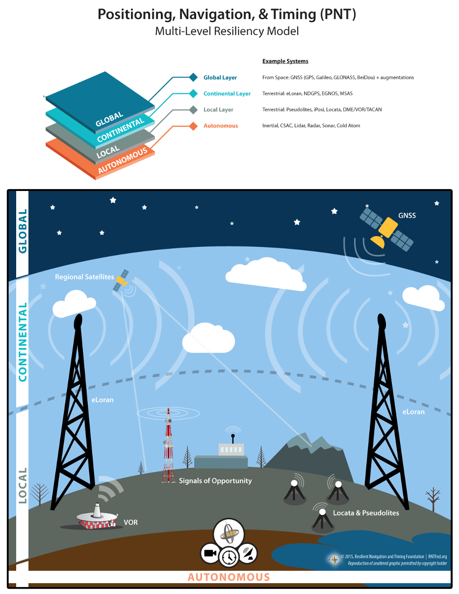
A National Resilient Timing Architecture should include delivery by fiber and RF along with space-based, according to the RNT Foundation. (Image: RNT Foundation)
The Resilient Navigation and Timing (RNT) Foundation has published a white paper proposing attributes for a government Request for Proposal (RFP) to acquire timing services.
Timing services, most of which are now sourced directly or indirectly from GPS, are essential for myriads of network, transportation, financial, industrial, and other applications. The National Timing Resilience and Security Act of 2018 (NTRSA) requires establishment of one or more systems to serve as alternatives and back up GPS timing.
The RNT Foundation’s October 2020 white paper discusses how a national timing architecture fulfilling the requirements of NTRSA could be established relatively easily and inexpensively. It proposes that, rather than building its own system, the government contract for services with commercial providers.
The new white paper outlines some of the requirements and evaluation criteria the government might use when acquiring timing services.
Goals
The paper postulates that the goal of such a procurement should be to establish a federal timing “backbone.” This would fulfill the requirements of NTRSA, which recognizes that timing is critical for many applications and is also the basis for most electronic positioning and navigation systems.
Establishing this backbone will provide users with an alternative and a safety net for GPS disruptions, and at other times enable more resilient and reliable services. As a backbone, it would provide basic, foundational services upon which others would be able to build. The new services would be expected to:
support a wide variety of public and private applications across the nation
be entirely independent from and have minimal or no common failure modes with GPS and other GNSS
provide multiple and diverse methods of timing delivery
serve both fixed and mobile users.
Regarding this last point, the paper notes that mobile devices must know their location before they can make use of timing signals. Thus, the selected system or combination of systems also will have to provide GPS-independent location information at a basic level to mobile users.
Requirements
Successful proposals, the paper envisions, will need to meet a number of requirements including
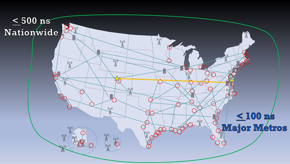
serving the entire U.S. land area, airspace, and coastal waters to about 200 miles offshore
enabling all fixed and mobile users to access at least one non-space-based source (to ensure no common failure modes with GPS/ GNSS)
timing accuracy in all locations to within 500 nanoseconds of universal coordinated time (UTC); this accuracy should be within 100 nanoseconds of UTC for the 50 largest metropolitan areas
one or more integrity measures to provide users confidence in system(s) accuracy
a very high rate of continuity and availability, similar to that of navigation beacons for aircraft
a performance monitoring and control system.
Evaluation Criteria
Fortunately for the government, numerous systems and companies are already able to provide the needed services. Deciding which to select will likely be a significant effort. Some of the evaluation criteria suggested by the RNT Foundation white paper are:
Annual Cost – While cost will not be the only consideration in this acquisition, the government always has a responsibility to taxpayers to weigh it as an important factor.
Infrastructure Required Per Unit of Coverage Area – This has been cited by the Department of Transportation as a very important consideration. Not only does the amount of infrastructure affect cost, but it also has implications for environmental and community impacts.
Spectrum – Signal disruption by in-band and out-of-band transmissions has been a significant issue for GPS. New PNT wireless and radio-frequency services should pose as few spectrum concerns as possible. Spectrum band reservations, licenses, pre-allocated bands, other bands and adjacent band uses will all be given consideration.
Penetration – While the government may not list this as a requirement, the ability of a service to reach underwater, underground and indoor locations will likely be desirable and part of proposal evaluation.
Resilience – The vulnerability of GPS signals to disruption will undoubtedly make the resilience of potential backup and complementary systems a major issue. The RNT Foundation paper discusses two kinds of resilience – operational and recovery.
Operational resilience is defined as “the ability of a system, combination of systems, or service to resist disruption (e.g.: jamming, spoofing, physical damage negatively impacting service).” One measure of resilience might be the energy needed to disrupt signals.
Recovery resilience is described as “The speed and ease with which a service can return to normal operation” after a disruption.
Cybersecurity – Similarly, cybersecurity is seen as having two components. The first is network security, defined as the degree to which systems are isolated from or connected to networks. Second is signal security, and is how well signals can be protected from infiltration and imitation.
Endorsements for GPS Alternative Timing
Since the “National Resilient Timing Architecture” white paper was issued in 2020, calls for GPS alternatives have intensified, and the white paper itself has received an important endorsement.
On May 7, the telecommunications industry standards group Alliance for Telecommunications Industry Solutions (ATIS) vigorously supported federal funding for GPS alternatives. In letters to leaders in both houses of Congress, ATIS cited “the urgent need for funding the deployment and adoption of Alternative Positioning, Navigation, and Timing (PNT) Systems in U.S. critical infrastructure, including the U.S. telecom industry.”
The need for federal support for timing and positioning backups for GPS was also supported by a two-year old study released by RAND Corporation in May. While the paper went to great lengths to argue against a duplicate GPS-like capability (something no one has supported to the best of our knowledge), it quietly suggested federal support for both a national timing system and location services to serve E-911 systems.
Numerous recent media releases from U.S. Space Force have revealed serious military threats to GPS and other space-based systems. A variety of killer-satellites, lasers and other weapons have turned space from a sanctuary into a potential battle ground. While not specifically calling for alternatives to GPS, the Space Force announcements have made it clear the nation needs to “get the bullseye off GPS.” Establishing at least one terrestrial alternative system similar to those operated by our adversaries will make U.S. satellites and signals much less attractive targets, according to Greg Winfree, former assistant secretary at the U.S. Department of Transportation.
Federal Funding Needed
Federal funding for improving national timing was specifically supported by a group of CEOs and senior executives from major telecom companies. Acting as the National Security Telecommunications Advisory Committee (NSTAC), the group’s May report to President Biden discussed GPS vulnerabilities and threats, and urged establishment of a capability
“…similar to that reflected in the Resilient Navigation and Timing Foundation’s paper entitled A Resilient National Timing Architecture. Further, to enhance the ability of commercial entities to afford leveraging this architecture, the Administration should appropriate sufficient funds to lay the foundation for creating this timing architecture, with the Federal Government being the first customer for what will ultimately become a resilient, interconnected network for PNT delivery.”
Federal funding support is necessary, according to NSTAC, because free GPS services greatly suppress market demand for alternatives.
The stated goal of a recently published RAND study was to answer a question from Congress about what should be done to back up and complement the nation’s GPS. One of its findings was that the government should consider investing in a national timing network.
Yet the study’s report emphasizes the wrong things, according to some. So much so that it is working against establishment of a timing network to reinforce GPS.
Report Misleading
“The main thrust of the study’s report is that we don’t need another GPS-like, system,” said Pat Diamond. “That has always been fairly obvious. I don’t know anyone who has ever advocated for duplicating GPS.” Diamond is CEO and founder of a network company and is a member of the president’s National Space-based Positioning, Navigation, and Timing (PNT) Advisory Board.
“By pounding so hard on the ‘don’t duplicate GPS’ drum, RAND hides its more important findings,” he said. “The public message comes across as there is no need to do anything.”
Diamond thinks the study should have better highlighted the things the federal government should do. “That is really the question Congress wanted answered,” he said.
RAND’s study supports four federal initiatives that “… appear to be cost-effective or close to cost-effective.” Included are a “timing-only” GPS-backup and support of high performance “geographically limited” systems.
Timing Essential, GPS Backup Needed
Cover: NSTAC
GPS timing signals are used in a wide variety of technologies including cell phones, IT networks, digital broadcast, first responders’ hand-held radios, and to synchronize electrical grids. Yet these signals from space are weak and easily disrupted.
A timing backup for GPS is also a long-standing recommendation of the president’s National Space-based PNT Advisory Board.
“There are few things more important to tech infrastructure today and tomorrow than timing,” according to Marc Weiss who was a lead researcher at the National Institutes of Standards and Technology for 35 years.
The RAND study was a cost-benefit analysis, which some have argued was not the best approach.
“Cost-benefit is always tricky,” says Greg Winfree, Director of the Texas Transportation Institute. “There are always a lot of assumptions. Small changes to any of the inputs can radically change the outcomes.” Winfree led civil PNT efforts during the Obama administration as an official at the Department of Transportation (DOT).
“One of my big concerns is that GPS is so important to so many things in America, that it is one of the most attractive targets for our adversaries. At least one alternate PNT that most people can access takes the bullseye off GPS,” Winfree said.
Scott Pace, director of the Space Policy Institute at George Washington University (GWU) agrees a diversity of PNT sources is important. At a recent GWU event, Pace commented having an alternative to GPS will contribute to national security and improve global stability. It will “lower the pressure on us to escalate and respond” should GPS satellites be damaged, or services disrupted. Pace was the Executive Secretary of the National Space Council in the Trump administration.
In the book The Russia Trap, author George Beebe has similar concerns, citing the lack of a backup for GPS as a technology resilience gap. Russia, China, and Iran all have terrestrial backups for PNT signals from space while the United States does not. Beebe says this is a weakness that can be exploited and could lead to an escalating series of exchanges resulting in all-out war.
Government Investment in Location Services
The RAND study suggestion for the government to invest in highly accurate PNT services in some limited geographic areas cited emergency responders’ needs for precise location. Federal investment will likely be required, it says, as commercial entities cannot make a business case everywhere service is needed.
GWU economics professor Diana Furchtgott-Roth has written that the federal government needs to provide a complement to GPS. She served as a Deputy Assistant Secretary at DOT from 2019 to 2021 leading civil PNT issues for the government.
“Without federal participation, commercial providers won’t ensure adequate resilient services for everyone. Some sectors, such as finance, will have it, but others won’t. This is a matter of national and homeland security. The RAND report did not emphasize this sufficiently.”
Questionable Timing and Motivation
“This is a particularly bad time for a confused message,” said a congressional staff member speaking about the RAND study. “Congress mandated a timing backup for GPS in 2018, though the project was never funded. There is real momentum this year to provide that funding, but the way this study reads works against that.”
Others see the structure of the study’s report and the timing of its release as a deliberate effort to derail budget negotiations. One retired Department of Homeland Security (DHS) official sees a pattern but is at a loss to explain the motivations behind it.
“RAND’s study was completed in 2019, and it was used as the basis for a DHS report to Congress in April 2020. But DHS didn’t tell Congress about RAND’s findings on a timing network and other actions the government should take,” they said.
“The study being made public now saying ‘do not back up GPS’ smells like a deliberate attempt to derail funding for the timing system. Something two presidential advisory boards, telecom leaders, RAND and so many others agree is needed.”
“Why would someone want to do that?” they asked. “Why would they want to keep America’s PNT so much weaker than China’s, Russia’s, and those of other countries?”
It said policymakers “could consider selecting the most resilient technologies as the cornerstone of the PNT suite for military missions, rather than defaulting to GPS.”
The 51-page report takes a comprehensive view of alternative PNT policy and leadership across the department. Its findings are an interesting and informative look at issues and efforts.
Increasing demands
The report comes at a time when U.S. forces have been seeing increasing interference with their own and allied GPS-enabled systems. The Organization for Security and Cooperation in Europe has regularly reported that its surveillance drones in the Ukraine have been jammed. Chinese press recently bragged that jamming caused U.S. Navy ships in the South China Sea to switch from using GPS to the Chinese BeiDou system. Additionally, U.S. military commanders have regularly described the Middle East as the most contested electronic warfare area on the planet, in large part because of regular interference with GPS signals.
The GAO study also comes on the heels of a provision in the National Defense Authorization Act (NDAA) for this year which directs DOD to provide non-GPS PNT to combatant commanders by 2023. The act says this timeline is consistent with responding to Joint Urgent Operational Needs, a formal method for commanders to communicate with department leadership. According to some sources, this suggests that the Pentagon has been receiving such requirements from field commanders, but has not responded to them in what Congress considers a timely manner.
Alternative PNT “not a priority,” resisted
Despite chronic GPS signal interference across the globe, outside experts and officials across the DOD told the GAO study team that developing alternative sources of PNT was not a priority for DOD. One example cited was the lack of a central program office.
One expert said, “PNT — It’s everyone’s need, but nobody’s business.” Another expert said, “Everyone wants to use [PNT], no one wants to pay or care for [PNT].” One DOD official characterized alternative PNT as an afterthought. DOD’s PNT Roadmap states that PNT capabilities, despite being mission critical, are not normally considered a key requirement, but rather may be treated as “a second-tier requirement.”
Worse, the report indicated that some forces within the department resist alternative PNT efforts.
According to one DOD official cited anonymously in the report “bureaucratic and political obstacles [represent] the biggest challenges for alternative PNT” and “anything that threatens GPS, such as alternative PNT technologies, faces pushback.”
The report cited another DOD official as agreeing that “there is an impression that the GPS program has a lot of political clout within DOD, and that those trying to develop alternative PNT technologies may face political challenges.”
Realistic requirements
Many missions do not need the accuracy provided by GPS, according to the report. Nevertheless. DOD programs often default to GPS performance standards when developing requirements. Many alternative technologies, while more resilient, are unable to achieve the same accuracy as GPS and therefore fail to meet the over-stated requirements.
Open architecture
Both DOD and GAO see development of modular open system architecture (MOSA) as key to PNT success in the future. This will allow addition of new PNT sources to a platform without the need for a major retrofit. With MOSA, all that would be needed is a new sensor module for the desired PNT source.
The GAO report endorsed this approach and encouraged DOD to institutionalize it with dedicated funding.
Working with industry
Decades of civil GPS use have benefited DOD in many ways. Broad academic and commercial research has resulted in a host of applications and improvements in the size, weight, and power requirements of equipment, as well as lowered costs. These benefits would almost certainly not have been realized at the current scale if the market for GPS equipment and apps had been restricted to military users.
The 2021 NDAA directs the department to “…enable civilian and commercial adoption…” of the GPS alternative technologies it develops for field commanders. The GAO report suggests DOD also work to leverage industry advances in technologies.
Scope and recommendations
GAO’s tasking for this effort did not include examining efforts to make GPS signals and equipment more resilient to disruption, nor use of non-U.S. satellite navigation systems. Neither were non-defense uses of PNT, nor improvements in such things as tactics, techniques, and procedures considered.
The study focused solely on department efforts to complement GPS services.
Six recommendations for policymakers are included in the report:
Increase Collaboration — Consider mechanisms to coordinate across DOD to clarify responsibilities and authorities in prioritizing the need for alternative PNT technologies.
Focus on Resiliency — Consider selecting the most resilient technologies as the cornerstone of the PNT suite for military missions, rather than defaulting to GPS.
Clarify Requirements — Consider opportunities to clarify what level of PNT performance is actually needed for missions, rather than defaulting to requirements that match GPS performance.
Coordinate with Industry — Consider ensuring that DOD and commercial industry coordinate so that industry is prepared to meet DOD’s needs, and DOD can leverage industry advances.
Institutionalize Open Architecture — Consider making the open architecture initiative more permanent, including providing funding.
Analyze Vulnerabilities — Consider having DOD conduct ongoing analysis of vulnerabilities of different PNT systems.
The May 2021 GAO report “Defense Navigation Capabilities: DOD is Developing Positioning, Navigation, and Timing Technologies to Complement GPS” is available here.
A May 5 webinar about the GPS Backup Technology Demonstration by the U.S. Department of Transportation (DOT) provided valuable insights about the project and intended way forward for PNT efforts in the department.
It also evolved into a policy discussion with former government leaders saying establishing alternative positioning, navigation, and timing (PNT) systems would make GPS safer by “taking the bullseye off,” and that “the time is now, before it is too late.”
The webinar, titled “What Technologies Can Secure GPS?”, was hosted by the Space Policy Institute at George Washington University (GWU). A bipartisan constellation of civil PNT stars gathered to participate in the event.
Featured in the webinar were:
introductory remarks by Robert Hampshire, chief scientist for the U.S. Department of Transportation (DOT). He has also been nominated to be DOT’s assistant secretary for research and technology.
a presentation by Karen Van Dyke, director, Positioning, Navigation and Timing for DOT, and Andrew Hansen of DOT’s Volpe Transportation Systems Center.
discussion of the issues by Diana Furchtgott-Roth, adjunct professor at GWU and a DOT deputy assistant secretary during the Trump administration, and Greg Winfree, director of the Texas Transportation Institute at Texas A&M University and DOT assistant secretary during the Obama administration, both of whom led civil PNT issues for the federal government during their time in office.
Scott Pace, director of GWU’s Space Policy Institute, serving as moderator; he was executive secretary of the Space Council during the Trump administration.
Hampshire opened the event with an address that touched on Biden administration themes of “building back better,” modernizing infrastructure, reducing transportation deaths, making transportation more efficient, and preserving America’s technological leadership. All of these were linked to the need to improve PNT resiliency and reliability.
Robert Hampshire, U.S. DOT chief scientist, speaking at GWU webinar on May 5. (Image RNT Foundation)
Backup tech demo did not close any doors
Van Dyke and Hansen then gave a presentation on the results of the department’s technology demonstration project.
Van Dyke pointed out that, while “GPS backup” may be a popular term, we need complementary capabilities that come into play not just when GPS is unavailable but work alongside it and provide additional capability and resilience all the time.
She also mentioned that the department is well aware there are more candidate technologies than those selected for the demonstration. Companies offering other ways of providing PNT will not be excluded from future consideration and efforts just because they were not part of the demonstration project.
Also, while the government collected the data during the demonstrations, she acknowledged that the effort was designed to “showcase the technologies in their best light.” Further study, stress testing, and evaluation will be needed for any system or technology that might be of interest to the government.
Key elements in the demos
Hansen discussed the particulars of how the technology demonstrations were conducted and some of the results. While the department evaluated 14 measures of effectiveness during the project, Hansen said that two were key — accuracy and coverage per unit of infrastructure.
All the technologies demonstrating timing showed accuracy that would be useful across a wide range of applications, he said. Positioning accuracy, though, varied from a “ones of meters to around 300 meters” depending on the technology.
Hansen said that coverage per unit of infrastructure varied exceptionally between the technologies. These included satellite systems that provide global coverage with a fixed infrastructure, and radio frequency systems with widely different coverage areas per transmitter.
He also observed that the technology demonstration project was not the end of the department’s technical inquiries. In fact, some of its results—such as eLoran performance in an underground scenario—were unexpected and are being further examined.
Transportation has some of the most stringent PNT requirements for accuracy, integrity, availability, and reliability, he said. And not all safety-critical transportation requirements may be met by market-based business models. Commercial systems lack the open standards and specifications that have made GPS so useful and widely adopted. Hansen said that the department will be working on these issues going forward, as well as performance monitoring for alternative systems.
A recurring theme throughout the webinar from all participants was that there is no single solution, no silver bullet, to achieve sufficient national PNT resilience. A systems-of-systems approach was needed. In Hansen’s words “a plurality of complementary systems” is required to ensure PNT reliability and safety, as well as efficient transportation.
Take the bullseye off GPS! — An urgent national security issue
While agreeing with the systems-of-systems approach, Greg Winfree pointed out that a first step still needs to be taken. He said that the nation has known about the need for alternate PNT since a 2001 report by DOT’s Volpe Center. Twenty years later, still no long overdue first step has been taken.
Just establishing the first alternative and complementary system, Winfree said, will make GPS and the United States much safer. “We need to take the bullseye off of GPS,” he said. GPS is so critically important to this country that it is a very attractive target for those who would do us harm. Having even one just alternative in place would make it much less of a target.
Diana Furchtgott-Roth pointed out that China, Russia, Iran and others have terrestrial systems that complement space-based PNT. About establishing alternatives, she said “The time is now, before it’s too late.”
Provisions in the United States National Space Policy provide that “[a]ny purposeful interference with or an attack upon the space systems of the United States or its allies that directly affects national rights will be met with a deliberate response at a time, place, manner, and domain of our choosing.”
Scott Pace also commented that an having an alternative to GPS will contribute to national security and improve global stability. It will “lower the pressure on us to escalate and respond” should GPS satellites be damaged, or services disrupted, he said.
Next steps
One of the questions posed at the end of the session was about actions and expected accomplishments in alternate PNT at DOT in the next 18 months. When could the first alternative system be expected?
The DOT technology demonstration report recommended that the department work next to develop standards and requirements for alternative systems. Current government employees were appropriately reluctant to say much more.
Calling upon her recent experience in government, however, Diana Furchtgott-Roth that said she believed that the department needed time to stress test technologies, develop standards and finalize requirements. Since many capable technologies were mature, some already in operation, she thought the first capability could be up and running within a year after that.
The only missing element according to Furchtgott-Roth is funding, and the focus needs to be on motivating Congress to provide it. The stage is set, she said, with all parties agreeing on the importance of resilient PNT.
She observed that it is very difficult to get the two parties in Congress to agree, and to pass legislation. Yet this has happened three times in support of establishing GPS alternatives. And PNT is such a critical capability that the entire executive branch even came together to protect it last year opposing the FCC’s decision in the Ligado Networks application.
She also related that, when she was in office, she requested $15M for the current fiscal year to do needed stress testing and standards development, but the funding did not appear in the budget.
One reason could have been questions she was asked about whether it is the government’s job to pay for an alternative to GPS, she said.
As a conservative economist her answer was and is a resounding “Yes.” The national need is beyond the business model of one company or private entity. That is something also suggested in DOT’s report on the tech demo.
Also, “enormous value and vast efficiencies” come from one entity funding such a utility, she said. “Just as the government funds national defense, it should also provide a complement to GPS.”
George Washington University’s Space Policy Institute reports a recording of the webinar will be posted on YouTube within the next week.
Dana A. Goward is President of the Resilient Navigation and Timing Foundation.
Senate poised to join House this week and override Trump’s veto
The U. S. Congress, especially the Armed Services Committees, have long been concerned about GPS and positioning, navigation, and timing (PNT) issues. Over the last two decades Congressional hearings, demands for reports, and investigations have dealt with acquisition, contingency plans for when space is not available, deliberate interference, and a host of other issues.
While these all evidenced Congress’ interest and concern, they were relatively passive measures.
The NDAA for 2021 seems to finalize Congress’ transition from an interested observer, mostly on the sidelines, to an active player in national PNT issues and policy.
This began to change in 2018 with passage of the National Timing Resilience and Security Act. It requires the Department of Transportation to establish a terrestrial timing system to backup GPS signals.
Then in 2019, Congress appropriated money for a GPS Backup Technology Demonstration. And the National Defense Authorization Act (NDAA) for 2020 required the Air Force to develop a prototype multi-GNSS receiver as part of its resiliency efforts.
The NDAA for 2021 seems to finalize Congress’ transition from an interested observer, mostly on the sidelines, to an active player in national PNT issues and policy.
Capitol Hill observers say this is the result of several things that have come to a head over the last year. Taken together, they have convinced many legislators that GPS is under threat and PNT issues are not being taken seriously enough by the executive branch. These include increased jamming and spoofing (especially by China and Russia), full implementation of China’s BeiDou system and its marketing to other nations as a superior alternative to GPS, the Federal Communications Commission’s (FCC) decision on Ligado Networks, and the Pentagon’s failure to respond to combatant commanders’ Joint Urgent Operational Needs Statements for non-GPS PNT.
Photo: Andrea Izzotti/Shutterstock.com
Here are some of the provisions of the 2021 NDAA of interest to the PNT community.
Military Multi-GNSS Receiver Prototype
The 2018 NDAA required the Defense Department to incorporate Europe’s Galileo and Japan’s QZSS satellite navigation signals into military user equipment. The idea was to make it more resilient to disruption. Also required was an investigation into using non-allied signals.
Apparently not satisfied with progress on this project, Congress mandated a project to develop a prototype multi-GNSS receiver as part of the 2020 NDAA.
The 2021 NDAA seems to indicate the Congress is still not happy. It withholds 20% of the funding for the Office of the Secretary of the Air Force until such time as the department certifies the prototype project is underway and provides briefings to the Senate and House Armed Services Committees.
Resilient Survivable PNT
Language in the 2021 NDAA also seems to show Congress is impatient with the Pentagon’s lack of responsiveness to combatant commanders’ requests for non-GPS PNT systems.
Section 1611 of the Act is entitled “Resilient and Survivable Positioning, Navigation, and Timing Capabilities.” It requires development, integration, and deployment of these capabilities for combatant commanders within two years. This, it says, is “… consistent with the timescale applicable to joint urgent operational needs statements…”
The act says the new PNT capabilities shall “generate resilient and survivable alternative positioning, navigation, and timing signals” and “process resilient survivable data provided by signals of opportunity and on-board sensor systems.”
The act also reverses the Defense Department’s 2018 PNT Strategy’s plan for future systems to be classified and for military use only. It directs the department to work with the National Security Council, Departments of Transportation, Homeland Security and others “to enable civilian and commercial adoption of technologies and capabilities for resilient and survivable alternative positioning, navigation, and timing capabilities to complement the global positioning system.”
To help ensure prompt action on this, the act requires a report to Congress within six months and authorizes the department to reprogram funds from other areas to finance the effort.
Responding to FCC’s Decision on Ligado Networks
By far the most PNT-related text in the 2021 NDAA includes a host of measures responding to FCC Order 20-48 approving an application by Ligado Networks. An order which the executive branch is on record as strongly opposing saying it will degrade GPS service for many.
Senator Jim Inhofe, chair of the Senate Armed Services Committee, has regularly expressed outrage at the FCC’s decision and has called for its reversal.
Among its provisions the act:
Requires the Department of Defense to estimate and report to Congress the cost of damage to department systems as a result of the FCC order.
Prohibits using department funds to upgrade or modify military equipment to make it resilient to interference caused by broadcasts in the spectrum allocated (the FCC order requires this to be funded by Ligado)
Prohibits contracting with any entity using the frequency bands allocated to Ligado unless the Secretary of Defense certifies the use will not interfere with GPS services
Requires the Secretary of Defense to contract with the National Academies of Sciences, Engineering, and Medicine for an independent technical review of the FCC order.
In 2018 the first-ever European Radionavigation Plan said “It is recognized that [..] GNSS should not be the sole source of PNT information. Alternative PNT systems, not necessarily using radio frequencies, should thus be put in place where the criticality of the application requires it.”
Graphic from MarRINav report showing system of systems approach to PNT resilience and reliability. (Image: Resilient Navigation and Timing Foundation)
In 2019 the European Space Agency (ESA) published a permanent open call for proposals for positioning, navigation, and timing studies and systems, including those that had nothing to do with space.
“Maritime navigation and port operations are critical for almost every nation,” said Jonathan Turner, one of the MarRINav project team. “As an island nation with a strong maritime heritage, we in the United Kingdom perhaps have an even greater appreciation of this.” Turner is co-founder of the blue economy solutions company NLA International, which led a team of eight organizations cooperating on the project.
While MarRINav focused its analysis on the United Kingdom, the intent was to provide information, and an analysis framework, that could also be used by other nations.
Maritime is one of sectors most dependent upon GNSS, according to the project reports, and a sector with great awareness of GNSS vulnerabilities and their consequences. MarRINav concludes that integrity and resilience are two of the most important parameters for maritime navigation.
Maritime is also one of the sectors most ready to integrate space and terrestrial navigation systems, according to the report’s authors. The International Maritime Organization has already introduced a performance standard for a multi-system receiver, or MSR, that will incorporate a wide variety of navigation signals.
Despite the distractions of Brexit over the last four years, the United Kingdom has been particularly focused on its vulnerability to GNSS outages.
In February of this year the UK government announced it was establishing a virtual National Timing Centre to protect the nation from the risk of GNSS failure, and in March the final MarRINav report was published.
Among the project’s findings are that:
The United Kingdom needs a comprehensive maritime PNT architecture with multiple, diverse sources to ensure continuity of maritime operations
Such a “hybrid solution” could benefit other sectors, especially if non-maritime needs were considered early in the design
New PNT systems should be terrestrial and sovereign
Establishing such a system for the UK has a very positive benefit to cost ratio
Important aspects of the new architecture are E-GNSS (Galileo and EGNOS), Enhanced Loran (eLoran) and the Ranging Mode (R-Mode) of the VHF Data Exchange System (VDES), and complemented by the development of a specific Maritime Receiver Autonomous Integrity Monitoring (M-RAIM) algorithm.
LOCATA or a similar local positioning system should be implemented at UK ports to provide a backup for container operations.
Satelles Satellite Time and Location may have potential, but its utility has yet to be demonstrated for maritime.
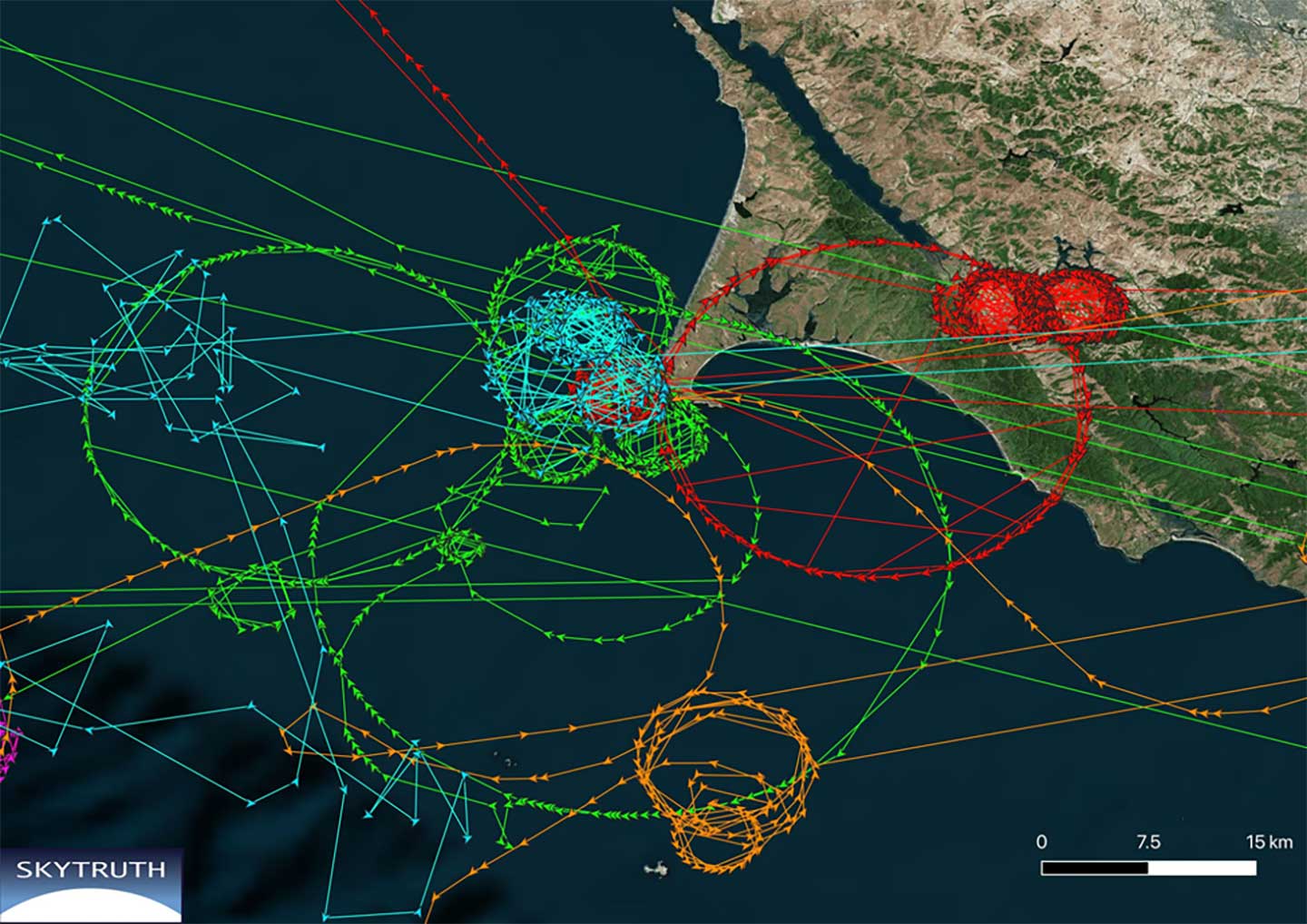
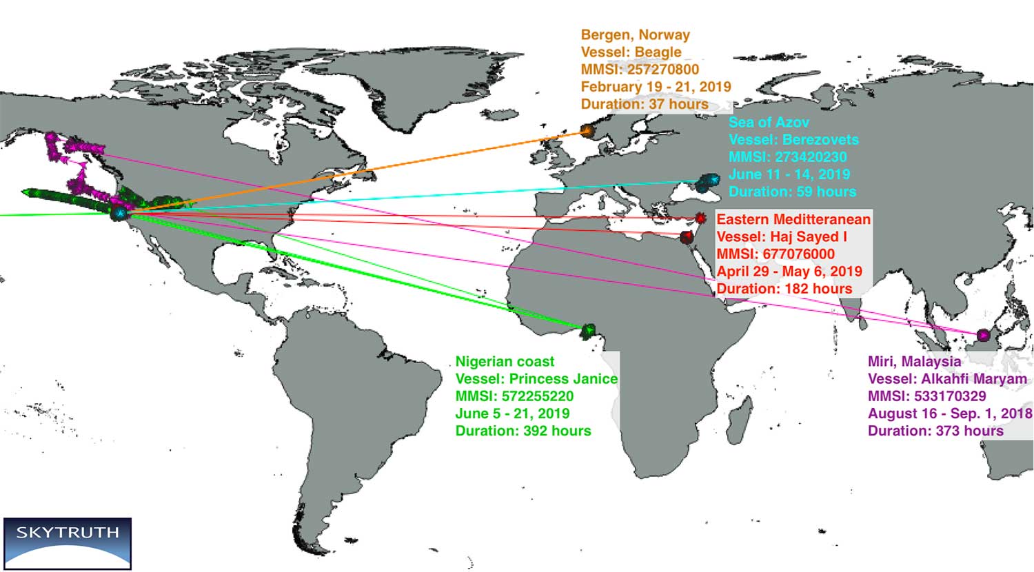
New research by Bjorn Bergman of the environmental non-profit SkyTruth has found ships in various parts of the world reporting locations thousands of miles away and circling at precisely 20 knots.
Bergman’s findings were first reported at the annual meeting of the Resilient Navigation and Timing Foundation on May 5.
Bergman previously observed and reported on circling phenomena with GPS-based reporting systems from vessels and fitness trackers in China ports. It has also been observed in Tehran, Iran. In all those cases, though, it was clear that the real location was fairly nearby the false and circling locations.
In the most recent observations, the actual locations of the ships were thousands of miles away. In most cases, literally halfway across the globe.
Image courtesy of Skytruth and RNTF.
Bergman said that he was able to verify the vessels’ approximate true location by examining the field of view of the satellite receiving the automatic identification system (AIS) position reports. The satellites are only able to see an area about 5,000 kilometers wide.
A satellite that could only see the Gulf of Guinea in West Africa, for example, received GPS-based location data from a ship’s AIS that showed the vessel offshore of Point Reyes in northern California. The vessels’ true locations were also confirmed by their position reporting before and after the “displacement events.”
Bergman was unsure if these errors are the result of the ships’ AIS systems or some fault or influence on GPS navigation receivers. It is clear that ongoing “circling” incidents in China are some form of GPS interference.
GPS-based fitness tracker reporting was affected the same way and at the same time as those of receivers on vessels. Bergman has been able to find no similar supporting data for these long-range displacement and circling events.
While Bergman was able to observe these events, he was at a loss to explain them. In previously observed cases it seemed clear a disruption device was nearby and affecting a large number of vessels. In these incidents, each vessel was the only one in its vicinity affected, and the vessels were separated by thousands of miles.
Image courtesy of Skytruth and RNTF.
Further hampering analysis, and making even speculation difficult, was the lack of commonality among the few cases observed.
The vessels were of much different types and operations. Pilot boats, work boats, tugs, cargo and passenger vessels were all involved.
The length of these disruptions also varied greatly. The shortest recorded was a reefer ship for less than half an hour. A crew boat was “displaced” for more than 16 days.
While most of the vessels reported circling positions off the coast of Northern California, two were displaced to Madrid, one to the vicinity of Hong Kong, and one to the Chinese city of Shanwei. One even began reporting it was circling a location offshore of northern California, and subsequently reported circling positions that drifted east almost a thousand miles inland to Utah.
A true mystery, the RNT Foundation is hoping to crowdsource ideas and share them with Bergman and other analysts. Anyone with insights or ideas about this mystery is encouraged to send them to [email protected].
A video of Bjorn Bergman’s presentation at the RNT Foundation’s annual meeting is available on the foundation’s website and below. He has also posted a short paper on these events on SkyTruth’s website.
Government officials, advisors and congressional staff gathered at NASA’s Langley Research Center on March 13. They were there to discuss the Department of Transportation’s (DoT’s) GPS Backup Technology Demonstration program and view the offerings of six different companies.
A second event to view and discuss technologies offered by the other five companies in the program is scheduled (as of this writing) for Friday, March 20, at Joint Base Cape Cod, Massachusetts.
View from Washington, D.C.
The day began with remarks by Karen Van Dyke from the U.S. Department of Transportation, as well as remarks prepared by Colonel Joseph Frankino, deputy director of the National Coordination Office, a multi-agency staff that supports the National Space-Based Positioning, Navigation, and Timing (PNT) Executive Committee, whose members were unable to attend.
Van Dyke provided an overview of the program and pointed out the increasing importance of resilient PNT. As just one example, improvements in autonomy and self-driving cars are entirely dependent upon consumers having confidence in the entire system, much of which is underpinned by PNT.
Col. Frankino’s remarks reflected the Defense Department’s commitment to and support of DoT’s resilient PNT efforts. He pointed out that the nation’s military depends upon the defense industrial base, which depends upon uninterrupted PNT.
Volpe Transportation Systems Center
The technology demonstration effort is being coordinated by Andrew Hansen from DoT’s Volpe Center. Dr. Hansen pointed out that the ongoing effort, the analysis and assessment of which is expected to be concluded in May, is a series of demonstrations vice tests. This means that the companies involved were showing what their systems could do, vice being measured against set criteria.
He also mentioned that the maturity of all the systems involved seems to have improved significantly over the last year. All are at Technical Readiness Level 6 or better. Also, that things so far had gone very smoothly with no need for any “re-dos.”
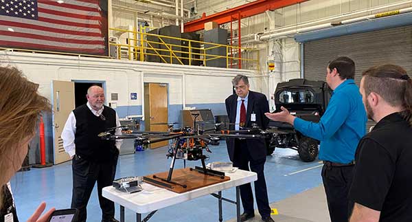
GPS and a cesium clock were being used as reference standards for the demos. Two of the systems, NextNav and Skyhook, were also demonstrated on a drone at Langley’s 150 acre open air site.
Report and Transparency
Data from the demos is not proprietary and belongs to the government which intends to make “as much of it available as possible.” DoT representatives mentioned several times their desire for maximum transparency.
Admiral (ret.) Thad Allen (left), chair of the National PNT Advisory Board, was among the attendees learning about DoT’s GPS Backup Technology Demonstration project at NASA’s Langley Research Center. (Photo: RNT Foundation)
Attendee Observations
After a day of viewing and discussing the six different technologies with their vendors, the group reconvened to offer feedback. All agreed the day was very worthwhile and complemented DoT and NASA on the event.
Kicking off the discussion, the DoT hosts remarked that the department is fully committed to GPS and its modernization. That said, there is broad recognition of the importance of other PNT systems. This is evidenced by the recent White House Executive Order on PNT.
Also, that there is no single solution that will fill the PNT needs of everyone. In fact, GPS does not serve the PNT needs of everyone. The need across sectors for a wide variety of sources to “backup” GPS is why the demonstration project includes some systems that only provide time, or only positioning.
Feedback from attendees included:
The reason for this project is that we have a 20th-century GPS and 21st-century threats. New technologies need to be examined for vulnerabilities. Security must be “baked in” from the beginning. Moderators commented that the DHS Conformance Framework was one of the tools that would help with this.
Rural and other underserved areas (such as wilderness, remote transportation networks, maritime) need PNT and should be a part of the government calculus.
Many systems depend upon infrastructure provided by others versus being self-sufficient.
In the view of many in Congress, it is good to see the demos going well. Overall, though, things are about two years late. Members and staff are very interested in when there will be an RFP and schedule for implementing the timing system mandated by the National Timing Resilience and Security Act of 2018.
Monty Johnson of the company OPNT demonstrates precise time transfer through 100 kilometers of spooled fiber-optic cable. (Photo: RNT Foundation)
Systems Demonstrated at NASA Langley
During the course of the day, attendees had the opportunity to interact with representatives from the following companies and their systems.
UPDATE: The search was called off on Tuesday afternoon. Additional information is available in this Evening Standard article.
David Last (Photo: @harriethallphoto via Dana Goward)
Just before 13:00 GMT on Nov. 25, a private plane piloted by David Last, former president of the Royal Institute of Navigation, disappeared from radar and hit the sea approximately two miles off the coast of Wales.
On-going search and rescue efforts have recovered pieces of wreckage and personal effects.
“Last was one of the most respected and well-loved figures in the worldwide positioning, navigation, and timing community. His loss creates a hole that cannot be filled,” said Dana Goward, president of the Resilient Navigation and Timing Foundation. “David was a close personal friend. Our grieving will not be brief.”
According to BBC News, the search for the missing plane and its pilot off the Welsh coast resumed on Nov. 26. North Wales Police said the light aircraft was flying from Caernarfon Airport to the Great Orme, Llandudno, and back on Monday when it disappeared. There were no other passengers and officers were supporting the missing pilot’s family.
The Maritime and Coastguard Agency said the search has resumed around Puffin Island, near Penmon, Anglesey. A plane carrying a sonar technology camera is searching the area as well as a lifeboat, helicopter and coastguard teams on foot.
David Last was a U.K. consultant engineer specializing in radio navigation and communications systems, professor emeritus at the University of Bangor, Wales, and past president of the Royal Institute of Navigation.
He also was a member of the expert panel and co-author of the January 2018 Blackett Report.
A report filed with NASA’s Aviation Safety Reporting System and published in June outlines how a passenger aircraft flew off course during a period of GPS jamming and nearly crashed into a mountain. Fortunately, an alert radar controller intervened, and the accident was averted.
Friedman Memorial Airport serves the ski resort town of Sun Valley, Idaho. Mountain peaks in the area are in excess of 12,000 feet. Airport arrival and departure procedures are carefully structured to ensure aircraft maintain safe distances from terrain.
According to the report, when “Aircraft X” arrived there was “…an abundance of smoke in the area” of the safe arrival route. Also “During this time there was widespread GPS jamming… Almost every aircraft was reporting…GPS outages.” Two previous flights had advised that their GPS signals were interrupted, but came back on line in time to make a safe approach to landing.
Aircraft X also reported problems with GPS, and then advised air traffic control that GPS had come back on line and was working well. The controller then cleared the aircraft for a GPS-based approach, including descending to 9,000 feet. Communications with and control of the aircraft was switched from Salt Lake Center (250+ miles away) to the tower at the local airport.
Shortly thereafter, the controller in Salt Lake City noticed Aircraft X straying off course. Also, it was at 10,700 feet altitude and nearing a 10,900 feet mountain. He quickly contacted the local control tower and the aircraft was directed back onto a safe flight path.
The report concludes that “Had [the Radar Controller] not noticed, that flight crew and the passengers would be dead, I have no doubt.”
Dana A. Goward is president of the Resilient Navigation and Timing Foundation.
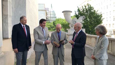
RNT Foundation Directors and Congressmen. From left: RADM Jeff Hathaway, USCG (ret); Rep. John Garamendi (D-CA); Rep. Peter DeFazio (D-OR); Dana A. Goward, SES, CAPT, USCG (ret); and CAPT Pauline Cook, USCG (ret). (Photo: Resilient PNT Foundation)
“It’s absolutely vital for national security that we get a terrestrial based, hard backup system [for GPS],” said Congressman Peter DeFazio (D-OR), chairman of the House Transportation and Infrastructure Committee.
His remarks came at an event organized by the RNT Foundation to recognize DeFazio and Congressman John Garamendi (D-CA) for their support of the National Timing Resilience and Security Act of 2018. Representative Garamendi is chairman of the House Armed Services Readiness subcommittee.
Garamendi first introduced legislation in 2016 to address the nation’s need for a GPS backup system. After going through several iterations, it was signed into law in December. The Act requires the Department of Transportation to establish a terrestrial timing system by 2020. Also, that the new system be expandable to one that can be used for location and navigation.
Congress funded a GPS Backup Technology Demonstration through a Department of Defense appropriation in early 2018. The demonstration was intended to be a joint project of the Departments of Defense, Homeland Security and Transportation. A delay in transferring funds from Defense to the other two departments put the demonstration almost a year behind schedule. Now that the project is underway, Transportation Department representatives have said they want to transition directly from the demonstration to deciding upon and implementing the mandated timing system.
At the event, DeFazio remarked that as a boater and hiker he is an avid user of GPS. He mentioned that it is an “ incredible utility, but I also know of its vulnerability. It’s critical to national security and the meaningful movement of everything in the United States of America from airplanes to surface transportation and others … It’s absolutely vital for national security that we get a terrestrial based, hard backup system.” He also noted that Congressman Garamendi has been the driving force for this issue in the House of Representatives.
Speaking about his current role on the Armed Services committee, Garamendi said “The reality is that the military is not prepared for the loss of the GPS signal, and they are just now becoming aware after seven years of beating them over the head saying ‘guys, what are you going to do when you don’t have GPS?’” Garamendi noted that the military would be a big users of the domestic backup system.
He also regretted that after “… years of people saying ‘single point of failure’ for the American economy and system is the loss of GPS” the nation is not farther along to having a backup system.
The RNT Foundation presented the congressmen with plaques showing images of a GPS satellite and a terrestrial transmission tower, and 0ne of America’s “first GPS devices” — a 102-year-old copy of The American Practical Navigator by Nathaniel Bowditch.