![]() The Railway High-Integrity Navigation Overlay System (RHINOS) work program explores candidate concepts for provision of the high integrity required for train positioning within a train-control system. GPS and Galileo plus satellite-based augmentation systems constitute the global reference infrastructure. In addition, local augmentation elements, advanced receiver autonomous integrity monitoring, and other trainboard sensors on can mitigate hazards due to environmental effects governing rail applications. RHINOS will be developed in cooperation with Stanford University researchers experienced in high-integrity aviation applications. The goal is moving beyond regional applications towards a global solution in the fast-growing train signalling market. RHINOS is financed by the European GNSS Agency and led by the Italian consortium RadioLabs, with partners Stanford University, Sogei, German Aerospace Center, University of Nottingham and University of Pardubice.
The Railway High-Integrity Navigation Overlay System (RHINOS) work program explores candidate concepts for provision of the high integrity required for train positioning within a train-control system. GPS and Galileo plus satellite-based augmentation systems constitute the global reference infrastructure. In addition, local augmentation elements, advanced receiver autonomous integrity monitoring, and other trainboard sensors on can mitigate hazards due to environmental effects governing rail applications. RHINOS will be developed in cooperation with Stanford University researchers experienced in high-integrity aviation applications. The goal is moving beyond regional applications towards a global solution in the fast-growing train signalling market. RHINOS is financed by the European GNSS Agency and led by the Italian consortium RadioLabs, with partners Stanford University, Sogei, German Aerospace Center, University of Nottingham and University of Pardubice.
Tag: rhinos
-

Research Online: An overview of the RHINOS work program
-
Defeating poachers with stealth
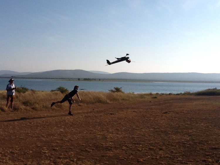
Night and day: UAV patrols defend dwindling elephant and rhino populations. To stem the staggering wildlife losses on the African continent from poaching, the Air Shepherd Campaign is employing a force of unmanned aerial vehicles (UAVs) equipped with GPS and infrared cameras.
Teams on the ground, in close cooperation with wildlife reserve management organizations, use the UAVs and sophisticated predictive analysis to hunt the illegal hunters.
More than 40,000 elephants were killed by poachers in Africa in 2014.The problem is similar for rhinoceros.
Poachers operate at night, when park rangers equipped with conventional aircraft can’t fly. Air Shephard searches for poachers using predictive analysis to determine the behavior patterns of both animals and poachers. Small drones with cameras search likely areas — once poachers are identified, pre-positioned rangers can intercept the suspects.
The hand-launched UAVs carry high-resolution cameras for both daylight and nighttime infrared scanning. At operating altitude, they can easily tell the difference between animals and humans, and transmit real-time geolocation information to the operating team on the ground. The UAVs fly for more than 1.5 hours; they are clean, stealthy and provide an eye-in-the-sky capability.
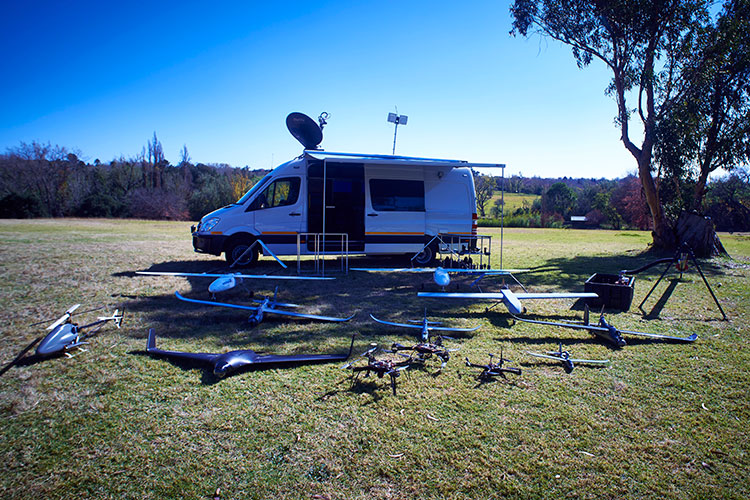
UAV fleet deployed around an Air Shepard mobile operating center. The Charles A. and Anne Morrow Lindbergh Foundation, originator of the Air Shepherd Initiative, has partnered with a dedicated group in South Africa that, over the last two years, has flown more than 650 drone missions over one of the most sensitive rhino poaching areas in Africa. During that period, no rhinos were lost to poachers where the UAVs were flown.
Once the process is proven, Air Shepherd expects it to be used in national parks and private reserves in South Africa and Botswana, then expand as funding increases to Namibia, Zambia, Tanzania, Gabon, Democratic Republic of the Congo, and eventually Asia.Learn more about the project at www.AirShepherd.org.