Tag: Ricoh

  • Latest Ricoh 360° camera uses u-blox module

    Latest Ricoh 360° camera uses u-blox module

    The Ricoh Theta X 360° camera uses a u-blox module for its location metadata. (Photo: Ricoh)
    The Ricoh Theta X 360° camera uses a u-blox module for its location metadata. (Photo: Ricoh)

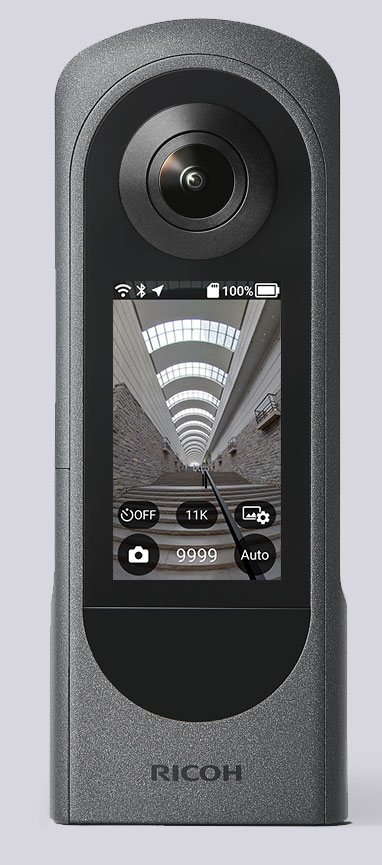
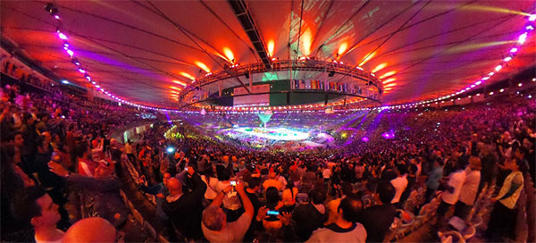
    The ZOE-M8B GNSS module from u-blox is integrated into the new Ricoh Theta X camera. The camera allows users to shoot high-quality 360-degree spherical images and videos in one click and visualize them immediately on an LCD touch panel.

    The u-blox ZOE-M8B enables the Ricoh Theta X’s built-in location system, one of its key features. The module is listed on the u-blox site as receiving GPS, BeiDou and GLONASS signals as well as QZSS, but the Ricoh Theta X specifications list only GPS + QZSS along with assisted GPS.

    The u-blox receiver automatically embeds highly accurate location information for each image taken, without the need for a smartphone or another external device.

    An icon on the LCD touch panel displays the availability of the GPS signals depending on the user’s location, ensuring the location information has been reliably acquired before shooting begins. The location is accurate down to a 5-meter radius, suitable for a wide range of industrial and consumer applications.

    The u-blox ZOE-M8B GNSS module is an ultra-small (4.5 mm x 4.5 x 1.0 mm) system-in-package offering highly accurate positioning with concurrent reception of up to three satellite constellations. The Super-E (Super-Efficient) mode guarantees power consumption as low as 12 mW, and built-in SAW and LNA make it suitable for passive antennas. The u-blox ZOE-M8B targets applications that require a small size without compromising performance.

    Part of a 360° spherical image shot with the Theta X. (Photo: Ricoh)
    Part of a 360° spherical image shot with the Theta X. (Photo: Ricoh)

    “We chose the u-blox module because of the highly accurate location information it offers, alongside easy integration and low power consumption,” said Kenji Daigo, GPS Function Developer for Theta X at Ricoh.

  • Ricoh’s G800SE Camera Designed for Information Workflow

    G800SE-Ricoh-W
    Photo: Ricoh

    Ricoh Americas Corporation has made major improvements to its water-, dust- and shock-resistant G800 camera. The G800SE model includes GPS and a barcode-reading capability that helps streamline workflows across a wide range of industries.

    The new Wi-Fi- and Bluetooth-enabled Ricoh G800SE allows for dynamic information capture in industries such as automotive, logistics, government, healthcare, emergency services and more. For example, a car dealership can scan the barcode on a new car, photograph the vehicle, and have the photograph and vehicle information flow directly to the dealership website for customers to see. This new workflow saves hours of painstaking information retrieval and organization, Ricoh said. With a standard camera, clerks would need to manually match images to each car, introducing the possibility of error at every step.

    “By embedding critical data into images, the Ricoh G800SE epitomizes information mobility, the ability for employees to access just the information they need in the form they need it to make important decisions,” said Matt Sakauchi, vice president, Technology Marketing, Ricoh Americas Corporation. “This is just one way we’re making customers’ business information work for them in this new world of work.”

    The Ricoh G800SE includes a host of upgrades over the previous generation of ruggedized Ricoh wireless-enabled camera, the Ricoh G700SE. For example, a higher-resolution image sensor provides a new ability to capture images under low-light conditions. The Ricoh G800SE also takes advantage of higher wireless transmission speeds and the more secure “enterprise” Wi-Fi increasingly seen in healthcare facilities and government agencies. It leverages the Protected Extensible Authentication Protocol (PEAP), an emerging standard in enterprise wireless security.

    A flexible password lock feature enables organizations to create separate passwords for administrators and users with each one unlocking different sets of permissions. A smartphone connection enables users to remotely operate the camera via their mobile devices. Using a smartphone or tablet, they can preview, zoom, shoot and capture image data, including GPS position. The capability is also intended for surveillance applications.

    Organizations can manage fleets of Ricoh G800SE cameras via remote management software with the ability to upgrade firmware, adjust camera settings and update memo functions. An alternative for camera configuration is distributing SD cards with prescribed settings.

  • Ricoh Unveils New Military-Grade Geotagging GPS Module

    RICOH AMERICAS CORPORATION SE-7 GPS
    Photo: Ricoh

    Ricoh Americas Corporation announced a new module for Ricoh digital cameras that provides the most advanced solution for precise, secure and portable military-grade photo/video geotagging.

    Available in August, the thumb-sized Ricoh SE-7 GPS hardware module bolts on to the ruggedized Ricoh G700SE digital camera. This combination enables users to automatically geotag images with location information immediately useful in navigation, mapping, planning, analysis, strategy, reporting and more.

    “The SE-7 module gives the military and other users important new capabilities for fast, precise and secure geotagging under less-than-ideal conditions,” said Yuki Uchida, Vice President, New Business Development, Ricoh Americas Corporation. “There’s a lot going on in this ultra-compact module to help soldiers and others be more successful in their work.”

    According to the announcement, the module, which sets a new standard in global positioning system (GPS) speed and accuracy, offers a more compact and convenient geotagging solution than traditional systems requiring a laptop-camera combination. The SE-7 also generates location coordinates down to the meter, which is far more precise than consumer-grade products. For even better accuracy, the Ricoh G700SE/SE-7 combination is forward-compatible to 18-satellite GPS processing, a military standard scheduled to take effect in 2016.

    Ricoh reports that the SE-7 module integrates directly with attachable laser range finders, includes a built-in compass for directional data capture, enables barcode tagging, and provides full support for selective availability anti-spoofing modules (SAASMs). SAASMs ensure GPS precision and accuracy even in the presence of malicious jamming and spoofing.

    Tagging

    The camera/module combination supports up to 20 memo fields that are customizable for tagging photographs with valuable data. Example data tags are photographer’s name, operation ID, operation type, unit ID and more. This information, along with GPS coordinates, GPS date and Zulu time, are automatically stored as metadata in each image file on the G700SE.

    Mapping and direction

    The SE-7’s GPS Track-Log feature maps the geographic path by which photographs are collected. An integrated electronic compass allows users to accurately record the direction in which a photograph is taken regardless of the angle at which the camera is held. After images are collected in the field, data is uploaded using the camera’s built-in wireless, Bluetooth or USB connection in preparation for analysis, mapping and reporting.

    Formats

    GPS coordinates collected with the SE-7 module can be displayed in a variety of formats directly on the camera, including LAT/LONG, MGRS, UTM and combinations of each, depending on user requirements. Data is compatible with a broad range of software, and images are plotted as a spatial data layer along with tagged information.

    Laser range finder integration

    Range finder integration allows users to tag not only where the picture was taken, but the location of objects in the distance being photographed.