UAV Navigation’s flight control solutions for remotely piloted air systems/unmanned aerial vehicles (RPAS/UAVs) are compatible with the Trimble UAS1 high-precision GNSS receiver. The core benefits of Trimble’s GNSS solution include centimeter-level precision and easy integration.
Image: UAV Navigation and Trimble
The light, small Trimble UAS1 receiver is less vulnerable to vibrations or temperature fluctuations, making it suitable for UAVs and RPAS. In addition, the receiver can provide real-time kinematic (RTK) positioning using a base station, enabling users to achieve higher precision for their projects.
Most UAV missions demand precision in its subsystems. The Trimble UAS1 receiver meets these requirements and includes a 336-channel high-precision GNSS engine. It tracks L1/L2 frequencies from the GPS, GLONASS, Galileo and BeiDou constellations.
The Trimble UAS1 supports OmniSTAR and Trimble CenterPoint RTX GNSS corrections, which enable precise and robust positioning without the use of a base station via a subscription service. The receiver also offers an industry-standard camera hot-shoe interface and a wide DC voltage range to work in a broad range of UAVs.
While Trimble is highly specialized in providing advanced GNSS solutions, UAV Navigation’s focus is on innovations in flight control systems. With this combined technology, current UAV/RPAS systems can now operate in more demanding environments and deliver higher precision through better navigation, UAV Navigation stated in a press release.
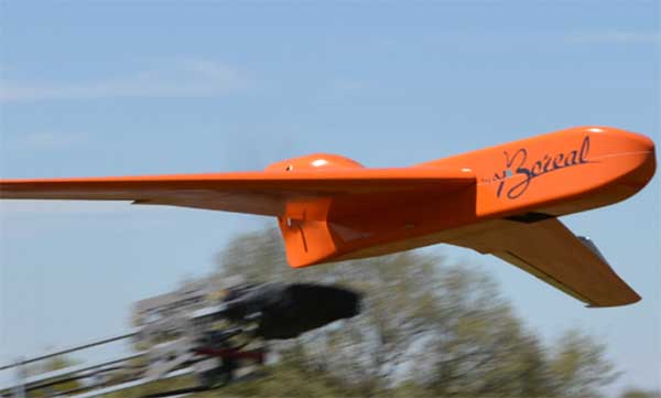
EGNSS improves positioning integrity and accuracy for the Boreal drone. (Photo: GSA)
News from the European GNSS Agency
The Skyopener project, co-financed by the European GNSS Agency (GSA), aims to pave the way toward increased use of remotely piloted aircraft system (RPAS) in civil applications.
The project has tested the benefits of multi-frequency GNSS and EGNOS in RPAS, revealing gains in availability, accuracy and robustness.
There is increasing demand to operate RPAS over long distances because of their potential for a wide range of civil applications. However, regulation regarding RPAS use in civil airspace does not yet allow beyond-visual-line-of-sight (BVLOS) operations, and remotely piloted aircraft are not allowed to fly in non-segregated civil airspace and are not yet widely used for civil and commercial applications.
This is something that Skyopener aims to change.
RPAS for civil applications. The project is developing operational processes that will reduce all categories of risks associated with RPAS and allow an air navigation service provider (ANSP) to manage very-low-level RPAS operations. Thanks to the benefits it offers in terms of improved integrity and positioning accuracy, EGNSS (Galileo and EGNOS) will play a central role in these processes.
Through these operational processes, Skyopener will contribute to the roadmap for the integration of civil RPAS into non-segregated airspace, which will have a huge impact on the service applications that can be offered by these aircraft.
“Systems that enable RPAS to fly safely, in compliance with regulations, will enable market access and significantly reduce the cost of insurance premiums for RPAS operators, making a wide range of RPAS applications more commercially attractive and widely used,” said Marc Pollina, CEO of Skyopener consortium member M3 Systems.
Excellent results. A test conducted by the project into the benefits of multi-frequency GNSS and EGNOS has delivered excellent results. The test found that the use of GPS and Galileo in L1/E1 and L5/E5 multi-frequency combinations provides improved availability, better accuracy and greater robustness against interference, as interference with one frequency band has no effect on the second.
What’s more, EGNOS helps meet increasingly stringent requirements for robust navigation, continuity, accuracy and availability — further complemented by Galileo’s multi-constellation capacity and integration with other sensors such as inertial or vision sensors.
The Boreal drone used in the project is a fixed-wing system that operates over a long range (more than 100 kilometers) in BVLOS, with EGNOS and Galileo enhancing navigation by improving positioning integrity and accuracy. In addition, the RPAS is equipped with a newly developed communication and navigation surveillance (CNS) system that combines use of GNSS, satcom and special security measures.
Essential GNSS. GNSS technologies are essential for RPAS. The primary need is obviously for navigation — the RPAS uses GNSS waypoints to follow the trajectory defined in its mission. However, GNSS also addresses other key needs, such as geofencing to ensure that the RPAS keeps within the mission parameters and surveillance to enable adequate tracking by the operator and civil aviation authority.
GNSS also enables high accuracy and, ultimately, automated landing and the geo-referencing of collected data. These benefits will increase in the future, with the Galileo authentication service reducing the risk of threats, and PPP data correction on E6 providing better geo-referencing.