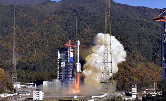
Four new satellites of the BeiDou Navigation Satellite System (BDS) have passed tests in orbit and joined the system to provide positioning, navigation and timing services, according to China news service Xinhuanet.
The four satellites include the 47th, 48th, 52nd and 53rd satellites of the BDS family, according to China’s Satellite Navigation System Management Office.
All of them, operating in medium Earth orbit, were developed by the China Academy of Space Technology under the China Aerospace Science and Technology Corporation.
The 47th and 48th BDS satellites were launched on Sept. 23, 2019, and the 52nd and 53rd BDS satellites were launched on Dec. 16, 2019.
Two to the Last. The China Satellite Navigation System Management Office said the last two Beidou-3 satellite launches will take place in March and May, and complete the Beidou system.
China began to construct its navigation system, named after the Chinese term for the Big Dipper constellation, in the 1990s and started serving the Asia-Pacific Region in 2012.
Over the past two years, China has successfully sent 28 BDS-3 satellites and two BDS-2 satellites into orbit.
China plans to launch more BDS satellites in March and May to complete the global network.
Yang Changfeng, Chief Architect, BeiDou Navigation Satellite System. (Photo: BeiDou)
By Yang Changfeng Chief Architect, BeiDou Navigation Satellite System
As one of the core Global Navigation Satellite Systems (GNSS) providers, the BeiDou Navigation Satellite System (“BDS”) has been developed steadily following a three-step strategy. BDS has been providing global services since the end of 2018. By around 2020, the BDS-3 system will be entirely completed to provide global users with free, open and high-quality navigation, positioning, timing, short message communication and other services. A more ubiquitous, integrated and intelligent positioning, navigation, timing system will be built before 2035.
In 2019, BDS has progressed with regard to aspects of system construction, integrated applications and international development.
System Construction
Accelerating Satellite Deployment. From January to November 2019, three BDS-3 satellites in inclined geosynchronous satellite orbit (IGSO) and four satellites in medium Earth orbit (MEO) were launched, and one IGSO satellite has completed in-orbit tests, to further improve the global system constellation.
The last two MEO satellites are planned to be launched by the end of 2019, marking the completion of the BDS core global constellation deployment. By June 2020, another two GEO satellites will be launched, and the full deployment of the BDS-3 system will be completed.
Ground System Construction. In 2019, 12 new ground operation and control stations (including one uplink station and 11 class-II monitoring stations) have been built, to complete the satellite-ground joint debug and integration tests, and the overall operation of the system is stable.
By the end of October 2019, 34 BDS satellites are operating in orbit to provide services to global users, including 15 BDS-2 satellites and 19 BDS-3 satellites.
Improving Service Performance
Key Service Areas. In May 2019, the last BDS-2 backup satellite was launched to further improve the performance in the key service areas of the BDS-2 system. As the BDS-3 satellites go into operation, the accuracy and availability of the BDS B1I and B3I signals, in the BDS-2service area, has been improved by about 30% and 5% respectively, compared with that of solely relying on the BDS-2 system.
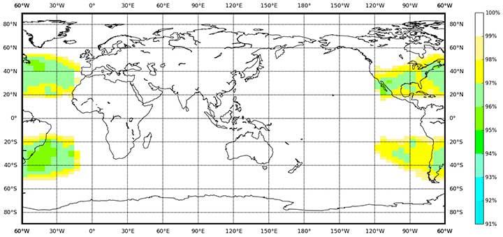
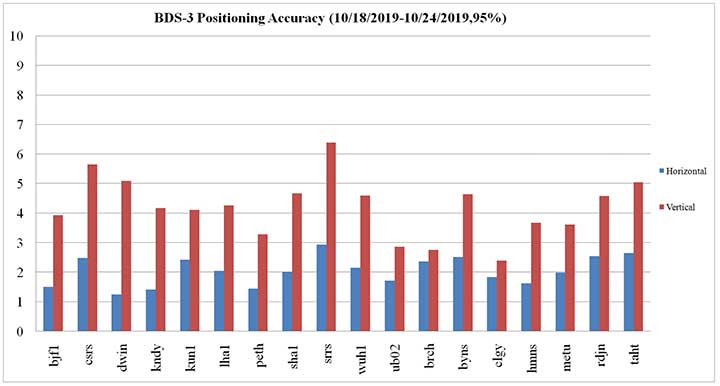
Global Service Areas. The BDS B1I and B3I service areas have been expanded from the Asia Pacific region to the world, and the accuracy and availability have been further improved. With the condition of PDOP ≤6, the availability is better than 99% in most regions all over the world (in parts of the United States, better than 97%). In the global area, the mean value of the actual measured positioning accuracy is about 3.6m horizontally and 6.6m vertically, velocity measurement accuracy is about 0.05m/s, and timing accuracy is about 9.8 nanoseconds (95% confidence). So far, the BDS-3 new signals, B1C and B2a, have possessed service capacity worldwide. The system availability is better than 87%, in the condition of PDOP ≤ 6. The mean value of the actual measured positioning accuracy is about 2.4m horizontally and 4.3m vertically, velocity measurement accuracy is about 0.06m/s and timing accuracy is about 19.9 nanoseconds (95% confidence).
Building of the Featured Capacity. The BDS/GNSS ground based augmentation system has been providing basic services. It consists of 155 framework reference stations and nearly 2,200 regional stations in China. The system has carried out high-precision applications in many fields, such as surveying and mapping, land resources, earthquake, transportation and meteorology. Its basic services include real-time positioning at the meter, decimeter and centimeter level, as well as precise post-processing positioning at the millimeter level.
The BeiDou Satellite-Based Augmentation System (BDSBAS) is being developed in accordance with International Civil Aviation Organization (ICAO) standards to provide navigation services with superior accuracy and integrity. In 2019, the first GEO satellite with the BDSBAS payload has been tested in orbit and the satellite is in good condition.
Integrated Applications
As the system construction accelerates, BDS is also making great efforts to strengthen the development of the fundamental products and applications in various fields. The integrated applications adopt the “BDS+” model to stimulate the growth of satellite navigation industry.
Fundamental Products. At present, the fundamental BDS products have been used in such areas as mass market applications, of which the performance has reached or is close-to the world-class level. The development of full-frequency integrated high-precision chips is near its completion, and the performance of the BDS chips will improve further. By the end of 2019, BDS navigation chips, modules and antennas have been exported to more than 100 countries and regions. In 2018, the domestic output value was more than RMB 300 billion (US$43 billion), in which the BDS contribution exceeds 80%.
Industrial Applications. BDS has been widely used in various fields — communication and transportation, public security, agriculture, forestry, animal husbandry and fishery, hydrological monitoring, meteorological forecast, time synchronization, power dispatching, disaster prevention and mitigation — generating significant economic and social benefits. In the field of transportation, by September 2019, more than 6.47 million road operating vehicles and 42,300 postal and express delivery vehicles in China are using BDS, and the world’s largest dynamic supervision system of operating vehicles has been formed, which effectively improved management efficiency and road transportation safety.
In agriculture, a BDS-based automatic driving system has been equipped on more than 20,000 sets of agricultural machinery and equipment, saving 50% of the labor cost. The BDS-based agricultural machinery operation supervision platform and the IoT platform has been serving 10 million units of agricultural machinery equipment, greatly improving management and operational efficiency.
In disaster prevention and mitigation, a tri-level platform covering the national ministry, the provinces, and cities and counties has been built to offer six-tier application services, with more than 45,000 terminals using BDS. The BDS/GNSS high-precision technologies have been applied in the field of geological disaster monitoring, while the landslides in Gansu province have been successfully forecast repeatedly, with time accuracy at the second level and deformation accuracy at the millimeter level.
Mass Market Applications. The BDS-based navigation and positioning services have been adopted by various enterprises in the fields of e-commerce, smart mobile terminal manufacture, location-based services (LBS), the sharing economy and the mass market, thereby changing people’s production and life style profoundly. Mainstream manufacturers in China and around the world have introduced BDS-compatible chips that integrate communication and navigation functions.
According to Chinese market statistics, in the third quarter of 2019, 151 types of mobile phones applying for license have positioning functions, among which 110 models support BDS. Using BDS/GNSS ground based augmentation stations, the spatial-temporal services including centimeter-level positioning, millimeter-level perception and nanometer-level timing services can be provided, while the accelerated positioning services cover 220 countries and regions with more than 390 million global users.
International Development
Bilateral Cooperation. BDS continues to carry out bilateral cooperation with other navigation satellite systems, to promote compatibility and joint applications. China and the United States have set up joint working groups in areas such as compatibility and interoperability, augmentation systems and civil services to continuously develop cooperation and exchanges.
China and the EU set up a technical working group on the compatibility and interoperability between the BDS and Galileo systems to carry out coordination, exchanges and cooperation, under the framework of the China-EU space cooperation dialogue and the International Telecommunications Union (ITU). The agreement between the Government of the People’s Republic of China and the Government of the Russian Federation on Cooperation in the Field of the Use of BeiDou and GLONASS for Peaceful Purposes has come into effect.
In August 2019, China and the Russian Federation held their sixth bilateral meeting in Kazan, Russia, signed the site survey certificate of GNSS monitoring stations, and achieved many cooperation results. In addition, the bilateral cooperation with Iraq, Tunisia and Saudi Arabia has also been steadily promoted.
Multilateral Cooperation. During the 62nd session of the Committee on the Peaceful Uses of Outer Space (COPUOS) in June 2019, an exhibition on ancient Chinese navigation technologies was held at the Vienna International Center with the theme “From Compass to BeiDou,” which vividly demonstrated China’s brilliant achievements in timing, mapping, cartography and navigation science and technology. In April and October, 2019, the second China-Arab States BDS Cooperation Forum and China-Central Asia BDS cooperation forum were held in Tunis and Nanning, China, respectively, to promote the BDS to serve the Arab region and Central Asian countries.
The BDS Overseas Applications Were Steadily Promoted. With BDS high-precision products being exported, BDS has been widely used in different regions and fields, such as land registration, precision agriculture, warehouse logistics in ASEAN countries, construction in Western Asia, airport timing and piling at seas in South Asia, electric power inspection in Eastern Europe, and land survey in African countries. As BDS-3 system continues to improve construction, it will provide quality services for more people in a wider area.
Ratification of BDS by International Standards. BDS has made a clear schedule to be ratified by the ICAO standards in 2020. It has formulated 26 standards in the field of international mobile communication based on the BDS B1I signal, and other standards based on the B1C and B2a signals are being developed. A receiver positioning result output protocol (NMEA0183) and a receiver data exchange format (RINEX 3.04) supporting BDS are to be released. Technical parameters and index information of BDS search and rescue (SAR) payloads are included in relevant COSPAS-SARSAT documents, and the development and in-orbit test of the first batch of SAR payload has been completed. The first BDS standard in the International Electrotechnical Commission (IEC) has been developed and approved and is expected to be released in June 2020.
Future Plans
After BDS achieves global service capabilities by 2020, it will further improve global navigation, positioning, timing and regional short-message communication services, and finalize global short-message communication, international search and rescue, satellite-based augmentation, precise point positioning, and other service capabilities. China’s BDS will contribute Chinese solutions to the world, and give full play of its role, with a renewed attitude, stronger capabilities and better services, to serve the world and benefit humankind.
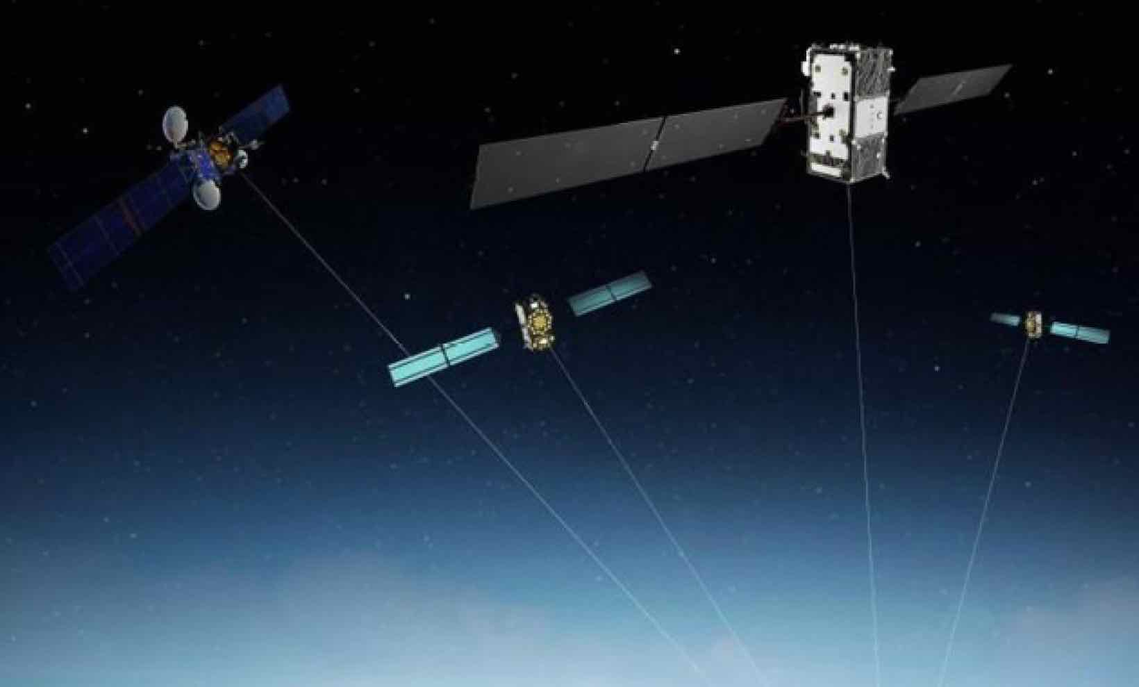
Galileo satellites GSAT0215, GSAT0216, GSAT0217 and GSAT0218, launched in December 2017, were commissioned for operational use as of Oct. 12, with all signals usable: Open Service, Public Regulated Service and Search and Rescue Service.
This increases the number of Galileo satellites that are available for service provision to 18. Initial operational capability for the constellation was declared on December 15 2016.
The additions to the GNSS almanac include the following:
GSAT0215: space vehicle E21 aka Nicole, occupying slot A03 if the constellation, with its payload running on a phased hydrogen maser (PHM) clock.
GSAT0216: E25, Zofia, slot A07, PHM clock.
GSAT02017: E27, Alexandre, slot A04, PHM clock.
GSAT0218: E31, Irina, slot A01, PHM clock
Each satellite weighs 715 kilo; measures 2.7 x 1.2 x 1.1 meters with a deployed solar array span of 14.67 meters; has onboard power of 1,900 W; and broadcasts navigation signals in 3 bands: E5, E6 and E1. Design life of the new satellites is more than 12 years.
Satellites GSAT-219 (Tara), GSAT-220 (Samuel), GSAT-221 (Anna) and GSAT-222 (Ellen) were launched on July 25 and are currently listed as under commissioning.
Galileo status information
Updated information on the status of the Galileo constellation can be found in the Constellation Status section of the European GNSS Service Centre’s (GSC’s) website.
Delivery person uses Galileo on a mobile device to deliver a package. (Photo: GSA)
According the the European GNSS Agency (GSA), more than 100 million devices are using Galileo today.
To keep track of Galileo-enabled devices serving a variety of needs as they become available, visit usegalileo.eu.
The Galileo Initial Services allow the use of Galileo Open Service (OS), which enables a free of charge, global ranging, positioning and timing service for the OS users.
Galileo is interoperable with the GNSS constellations (GPS, GLONASS, Beidou). By offering dual frequencies as standard, Galileo is set to deliver real-time positioning accuracy down to the meter range.
For questions about Galileo, contact the GSC Helpdesk.
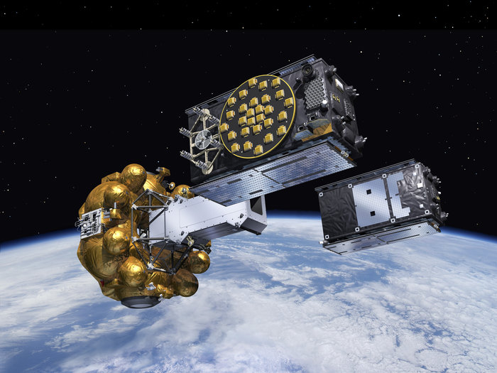
Four Galileo satellites were added to constellation in October 2018. (Image: GSA)
Galileo Fregat upper stage flew the latest two Galileo satellites most of the way up to medium-Earth orbit before they finally separated. (Artist’s concept, courtesy of ESA).
Galileo satellites 11 and 12 lifted off together on Dec. 17 atop a Soyuz rocket, and successfully deployed in space four hours later. The pair effectively doubles the number of Galileo satellites in space over the last nine months.
Five satellites are now set operational to the user. Once 9 and 10 (launched in September 2015) as well as 11 and 12 are set operational, a total of nine usable satellites will be in orbit. Satellites 5 and 6 may be partially usable at some point.
“Along with the ground stations put in place around the globe, this brings Galileo’s completion within reach,” said Jan Woerner, director general of the European Space Agency.
“Production, testing and launch of the remaining satellites are now proceeding on a steady basis according to plan,” added Didier Faivre, ESA’s director of Galileo and navigation-related activities.
Starting with launches in the third quarter of 2016, four rather than two satellites at a time will rise into orbit. This accelerated deployment should bring 30 satellites on line — 24 operational and six orbit spares — by 2020 for full operational capability of the European GNSS. Initial operating capability is foreseen by the end of 2016.
“The target is initial service next year, with a reduced constellation, for the Open Service, Public Regulated Service and Search-and-Rescue,” said Carlo des Dorides, executive director of the European GNSS Agency (GSA). “We will also start proof-of-concept testing for the Commercial Service. The performance will be reduced in terms of availability and continuity because of the reduced number of satellites — but not in terms of accuracy.”
Fundamental Elements. For the benefit of users and industry on the ground, the GSA announced in September the provision of 100 million euros ($110 million) to promote development of chipsets and receivers. Slated for distribution between 2015 and 2020, the funds are to stimulate market reception for Galileo. The announcement followed a paper published by the Galileo Services industry consortium urged accelerated investment by European governments to safeguard competitiveness of European manufacturers with U.S. and Chinese industry in the satnav user equipment market.
Sensitivity on PRS. Sorting out access to the encrypted Public Regulated Service (PRS), even among the 28 EU member nations, involves some thorny issues. EU officials have grappled with so-called Common Minimum Standards that set rules on PRS access for national government agencies and PRS hardware manufacturers, with the goal of ensuring that the encrypted signal is not compromised. The diversity of EU nations’ security precautions is wide enough that the European Commission (EC) has reserved the right to conduct inspections of agencies and companies working with PRS to verify compliance. Each nation using PRS will create a specialized agency responsible for its use.
Due to the sensitive subject matter, the EU will not publish supporting documents for the Common Minimum Standards in the EU’s Official Journal. The standards were nonetheless approved in November.
Nations outside the EU face a more difficult path to PRS. Norway and the United States have applied. Both are members of the North Atlantic Treat Organization (NATO), and military use by all agreeing parties is a tacit aspect of the PRS. The next step to granting U.S. and Norwegian access is for the EU’s highest decision-making body, the European Council, to give the European Commission authority to open negotiations with U.S. and Norwegian authorities.
New ICD. In late November, the European Commission published a new release 1.2 of the Galileo Open Service Signal In Space Interface Control Document (OS SIS ICD v1.2).
GPS Fully Funded, Minus $2 Million
In late November, President Obama signed the National Defense Authorization Act (NDAA) for Fiscal Year 2016, after vetoing a previous version. The enacted NDAA complies with the two-year budget agreement, which called for a reduction in defense spending.
The act reduces the GPS IIF line item by $2 million, citing “unjustified support growth” from the U.S. House of Representatives Committee on Appropriations, but otherwise recommends full funding for the Air Force GPS program ($936.775 million).
Privacy Uptaken. In other Capitol developments, Sen. Al Franken (D-MN) reintroduced the Location Privacy Protection Act. According to the senator’s office, “The Location Privacy Protection Act of 2015 closes legal loopholes that allow stalking applications to exist on smartphones.
“Sen. Franken’s bill fixes this problem by requiring companies to get customers’ permission before collecting their location data or sharing it with third parties.”
The three BeiDou satellites launched this year are sending twice as many signals as their predecessors, reports the Economic Times, following tests of the orbits and key technology.
The 18th and 19th satellites are the first BeiDou satellites that can communicate with each other, helping with distance measurements, said Wang Ping, chief engineer on the project.
After the tests, they are working as intended and in all weather, according to a newsletter from the China Academy of Space Technology.
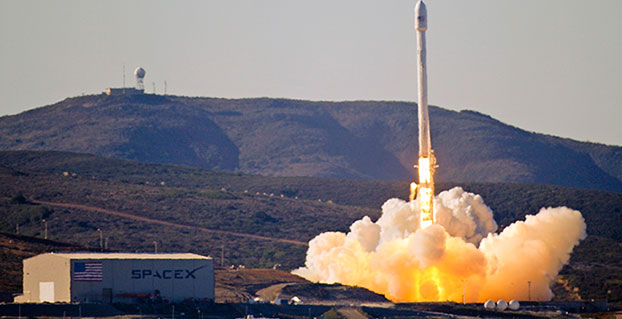
Team Vandenberg launches its first SpaceX launch from Space Launch Complex-4 Sept. 29, 2013. 30th Space Wing’s 1st Air and Space Test Squadron was the lead for all launch site certification activities at Vandenberg for SpaceX as an EELV New Entrant. The squadron evaluated SpaceX’s flight and ground systems, processes and procedures for the upgraded Falcon-9 rocket. (U.S. Air Force photo/Airman Yvonne Morales)
The U.S. Air Force has certified SpaceX’s Falcon 9 rocket to launch military satellites, clearing the way for SpaceX to bid on launches of GPS III satellites. The Air Force announced the decision May 26, which completed a nearly two-year process and establishes a competitor to United Launch Alliance.
SpaceX, based in Hawthorne, Calif., is now eligible for award of qualified national security space launch missions as one of two currently certified launch providers. The first upcoming opportunity for SpaceX to compete to provide launch services is projected to be in June when the Air Force releases a Request for Proposal for GPS III launch services.
“This is a very important milestone for the Air Force and the Department of Defense,” said Secretary of the Air Force Deborah Lee James. “SpaceX’s emergence as a viable commercial launch provider provides the opportunity to compete launch services for the first time in almost a decade. Ultimately, leveraging of the commercial space market drives down cost to the American taxpayer and improves our military’s resiliency.”
This milestone is the culmination of a two-year effort on the part of the Air Force and SpaceX to execute the certification process and reintroduce competition into the Evolved Expendable Launch Vehicle (EELV) program. The Air Force invested more than $60 million and 150 people in the certification effort which encompassed 125 certification criteria, including more than 2,800 discrete tasks, three certification flight demonstrations, verifying 160 payload interface requirements, 21 major subsystem reviews and 700 audits in order to establish the technical baseline from which the Air Force will make future flight worthiness determinations for launch.
“The SpaceX and SMC teams have worked hard to achieve certification, said Lieutenant General Samuel Greaves, commander of the Air Force Space and Missile Systems Center. “And we’re also maintaining our spaceflight worthiness process supporting the National Security Space missions. Our intent is to promote the viability of multiple EELV-class launch providers as soon as feasible.”
“This is an important step toward bringing competition to National Security Space launch. We thank the Air Force for its confidence in us and look forward to serving it well,” said Elon Musk, SpaceX CEO and lead designer.
The certification process provides a path for launch-service providers to demonstrate the capability to design, produce, qualify and deliver a new launch system and provide the mission assurance support required to deliver national security space satellites to orbit. This gives the Air Force confidence that the national security satellites being delivered to orbit will safely achieve the intended orbits with full mission capability.
The SMC, located at Los Angeles Air Force Base, Calif., is the U.S. Air Force’s center for acquiring and developing military space systems. Its portfolio includes GPS, military satellite communications, defense meteorological satellites, space launch and range systems, satellite control networks, space based infrared systems and space situational awareness capabilities.
Planet Earth gained five new navigation satellites in late March, for four satellite systems.
GPS. The U.S. Air Force’s ninth GPS Block IIF satellite (GPS IIF-9) launched on March 25 from Cape Canaveral, Fla. The IIF-9 rode aboard a Delta IV rocket, the workhorse of the GPS fleet for successful launches. The satellite was declared operational on April 21.
“Many thought the Delta IV and GPS days were long gone, but the recent questions concerning reliable and proven launch vehicles have brought them back online, so to speak,” said GPS World Defense Editor Don Jewell. “The 20-year milestone for GPS space vehicles on orbit that occurred on April 27 translates to approximately 500 orbital years just for the IIR and IIF constellations alone. The IIAs may account for that many orbital hours as well.
“This is by far the most successful launch record ever put together by any nation or government. No other space-faring nation even comes close. The U.S. Air Force and all the players should be proud of all these records and more, plus we have one more GPS asset on orbit, providing GPS signals to the world and all they enable, courtesy of the USAF.”
Galileo. Two days later, March 27, a duo of Galileo satellites was successfully launched from Europe’s Spaceport in French Guiana. The seventh and eighth Galileo satellites rode aboard a Soyuz ST-B rocket. Both are in their planned orbits.
IRNSS. The next day, March 28, the fourth satellite (IRNSS-1D) ofthe IRNSS satellite navigation constellation was launched onboard PSLV-C27, and reached its orbital slot April 9. The Polar Satellite Launch Vehicle blasted off from the Satish Dhawan Space Center on India’s east coast, in the 28th consecutive successful PSLV mission.
BeiDou. On March 30, China launched the first of a new generation of navigation satellites, BeiDou-3 M1, for its BeiDou constellation. BeiDou-3 M1 is the first of 17 next-generation Beidou navigation satellites. It will have a new navigation signal system with inter-satellite links and other tests to verify the satellite navigation system. The new series of satellites is expected to mark an advancement in the completion of Beidou Phase III several years ahead of schedule, by as soon as 2017 rather than 2020.
GLONASS. Not making the March launch cut, GLONASS kept its hat in the orbit ring, so to speak, by issuing some far-sighted predictions. Nicholas Testoyedov, CEO of Information Satellite Systems Reshetnev, said that the first GLONASS-K2 spacecraft will be launched into orbit in 2018. “New code division (CDMA) signals will be emitted, so it will provide more accurate positioning for users.”
The GLONASS budget for 2015 will be cut by more than 5 billion rubles, a drop of more than 10 percent. GLONASS is also suffering through an embezzlement scandal, related to construction of a new ground control center.
Galileo’s worldwide ground segment as of March 2013.
Galileo Ground Upgrade
On April 9, the European Space Agency announced completion of a full-scale hardware and software migration to version V2.0 of its global Ground Mission Segment providing all Galileo navigation messages. The Ground Mission Segment was turned off Jan. 26, allowing the migration to take place over the month of February. March was taken up with detailed checking by operations and system, concluding in a final check on March 31 to validate the successful migration.
“The upgrade has provided better overall performance and availability, along with improved robustness, security and operability,” explained Martin Hollreiser, overseeing mission segment development for ESA, with Thales Alenia Space France as prime contractor. “An overall 25 percent performance improvement is confirmed.
“Three new sensor stations, Kiruna, Ascension and Azores — used to monitor the satellite navigation signals — were added to the operations chain, as well as a new uplink station in Papeete, to uplink corrections incorporated in the navigation message to the satellites for broadcast to the users.”
The Ground Mission Segment at its core is determining the exact satellite orbits and synchronizing all the satellite and terrestrial elements of that clock: the relevant control center is linked to a global network of ground stations (sensor and uplink stations). The Galileo signals currently undergo technical testing, with early services for the public projected for 2016. “A further update is foreseen for the end of this year,” Hollreiser added, although this will occur with no interruption of services.
GPS Glitch Dates from 2011
On April 15, the U.S. Air Force GPS Directorate said data analysis shows that a technical error affecting some GPS IIF satellites first appeared in 2011. The error affects the way the ground control system builds and uploads messages transmitted by the satellites, but does not affect the accuracy of GPS signals. It involves the ground-based software used to index messages. “A GPS message indexing issue was recently identified that affects a limited number of active GPS IIF satellites, but does not degrade the accuracy of the GPS signal received by users around the globe. The result is an occasional broadcast not in accordance with U.S. technical specifications. ”