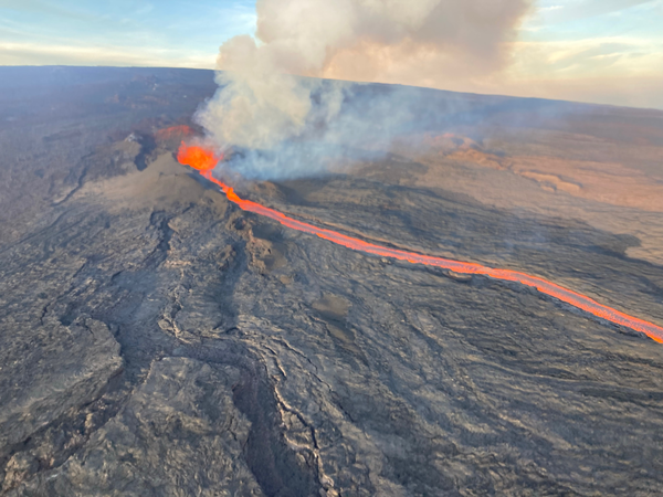
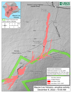
In late November, the Mauna Loa volcano in Hawaii erupted for the first time since 1984 and is currently in an active volcanic eruption. Scientists are using satellites and helicopters to record and map the flow of lava on the Big Island.
The active eruption is in a remote area on the island, making it difficult to map it and the lava flow. It is critical to have accurate emergency information during the eruption in order to have appropriate resources and have ample time to evacuate, if necessary.
The easiest and most accurate way to map the lava from this eruption is via satellite. Based on satellite observation, scientists have been able to create a mobile app to support helicopter crews in making maps of lava flow that update in real time. This real time evaluation is sent to emergency personnel and geologists tracking the eruption patterns.
Image: USGS
Mauna Loa has erupted 33 times, the most recent of which was 38 years ago. The volcano typically averages an eruption every 5 years, making Mauna Loa’s most recent dormant period longer than normal. According to the U.S. Geological Survey (USGS), this eruption was caused by an increase in earthquakes below the Mauna Loa Summit, an increase of inflation tracked by GPS stations, and several additional geologic factors.
Live footage of the Mauna Loa eruption can be seen here.
Operators of UK transport networks will be the first to benefit from Live Land, a satellite-based land monitoring system developed through the European Space Agency (ESA).
Transport operators across the UK face significant challenges in monitoring and detecting landslides and subsidence across their networks. Geological hazards in the vicinity of roads and railways can disrupt business and communities.
The Live Land demonstration project will help to assess and monitor high-risk areas by providing more information on geological hazards along rail and road networks using integrated data from GNSS and Earth observation satellites.
CGG GeoConsulting‘s NPA Satellite Mapping group has been awarded a contract to lead the Live Land project, sponsored by the ESA within its Integrated Applications Program (IAP). Over the next two years, the Live Land consortium will develop a number of products for two prominent Scottish transport operators, Network Rail (Scotland) and Transport Scotland.
Once successfully demonstrated in Scotland and regions of England, Live Land is expected to expand across the UK and continental Europe as the project team engages with other transport operators who could benefit from the new information that will be available on geohazards.
The Live Land demonstration project is the follow-on of a previous ESA IAP feasibility study concluded in 2014 and draws on expertise from a team of internationally respected authorities in their respective fields:
Live Land offers transport operators increased information on geological hazards, such as landslides and subsidence. (Photo: ritish Geological Survey NERC)
How it works
Radar images from Europe’s Sentinel-1A observation satellite detect surface motion changes with millimeter precision. This is complemented with data from satnav receivers and sensors installed for in-situ monitoring in specific locations. This space-based information is combined with knowledge about the geology of the area and weather forecasts. For example, an area of steep slopes and wet soil that is expecting heavy rainfall is at a higher risk of a landslide.
Furnished with such knowledge, transport operators can assess the risks and improve their planning and response to incidents.
“Live Land integrates data collected from different sources to assess and monitor potential geological threats for transport operators,” said ESA’s Roberta Mugellesi. “Combining space-based data increases the confidence in risk assessment and predictions.”
NPA Satellite Mapping
The NPA Satellite Mappingconsultancy derives geospatial intelligence from satellite imagery. Its mapping solutions are used around the world by a client base ranging from oil and gas operators to transport asset owners to maximize operational insight and minimize risk. The company has considerable experience in geohazard research projects for ESA and European Commission, and, with its expertise in satellite InSAR (surface deformation) mapping, is optimally placed to coordinate and bring to market the unique monitoring solutions that will be developed within the Live Land project.
The services are expected to range from regional geological hazard susceptibility and activity datasets that exploit satellite InSAR measurements, to hazard forecasting models using geological and meteorological data, and the development of cost-effective, multi-sensor devices (GNSS receiver and inertial sensors) for in-situ monitoring.
“Live Land will initially play a crucial role in helping to better understand, monitor and forecast geological hazards across the UK’s road and rail networks,” said Claire Roberts, Live Land project manager and remote sensing consultant with NPA Satellite Mapping. “The developments targeted in the project are ambitious but necessary given the scale of the issues we want to address.”