Merger to deliver high-end performance and ultra-accurate timing and frequency products for commercial, critical infrastructure and defense markets worldwide
Orolia has entered into a definitive agreement to acquire Seven Solutions, a global innovator in White Rabbit sub-nanosecond time transfer and synchronization technology. This transaction is subject to customary closing conditions and approvals required by the Spanish government and is expected to close before the end of the year.
This is Orolia’s 11th acquisition in the past seven years.
The merger with Seven Solutions, based in Granada, will enhance Orolia’s portfolio for defense, aerospace, data centers, telecom, financial services, smart grids and other critical infrastructure industries, and will enable the next-generation applications dependent on ultra-precise, resilient timing and frequency technology.
“Orolia and Seven Solutions under one umbrella will combine our world-leading technologies to draw a new frontier in network timing to sub-nanosecond levels, delivering the most robust and accurate resilient PNT solutions for our customers,” said Orolia CEO Jean-Yves Courtois. “Seven Solutions’ long history of delivering cutting-edge time distribution solutions to sectors like telecommunications, smart grids, aerospace, defense and scientific facilities aligns perfectly with Orolia’s DNA.”
Orolia and Seven Solutions will integrate global sales, marketing, product development and operations.
Orolia’s full-scale, modular approach to resilient PNT includes atomic clocks with a combination of GNSS signals protected with interference detection and mitigation technology, together with low-Earth-orbit secure alternative signals. The addition of Seven Solutions’ products will deliver terrestrial sub-nanosecond time distribution from distant and potentially redundant locations.
“We believe the union of our companies will produce the future of time transfer and frequency distribution solutions in terms of accuracy, reliability and interoperability,” said Rafael Rodriguez, chief technology officer and co-founder of Seven Solutions. “Finance, 5G telecommunications, data centers and hyperscalers have new and upgraded functionalities requiring ultra-accurate time distribution accuracy. To maximize interoperability, our solution for time transfer is based on the White Rabbit concept that has been pushed over the last decade to become the basis of the standard high accuracy time transfer profile (within the recent release of IEEE 1588 of precision time protocol).”
Orolia and Seven Solutions are members of the Open PNT Industry Alliance. The international organization focuses on market concepts that strengthen economic and national security by supporting government efforts to implement resilient PNT capabilities for critical infrastructure.
A notice of award was posted Oct. 11 by the European Union for seven contracts to six different companies for demonstration of non-GNSS positioning, navigation, or timing solutions.
The awardees are OPNT BV from the Netherlands; Seven Solutions SL from Spain; SPCTime of France; GMV Aerospace of Spain; Satelles Inc. of the United states; and Locata Corporation of Australia.
Locata received two separate contract awards: one to demonstrate delivery of time, and the other for positioning.
According to the EU project officer, Ignacio Alcantrailla-Medina, some of the awardees will demonstrate delivery of time, some positioning, and some both. Locata received separate awards because the company provided separate responses for timing and positioning.
Eleven different companies responded to the tender, according to the announcement. No information was provided on the unsuccessful bidders.
The EU tender for this project was announced in October 2020. The stated goal of the project is to better understand available non-GNSS PNT technologies. The intent is to identify potential backups for GNSS during an outage. All offered technologies were required to be able to operate independently from and have “no common points of failure with” GNSS.
Alcantrailla-Medina says the demonstration project is expected to last seven and a half months. As part of this, a public event will be held at the EU’s Joint Research Center in Ispra, Italy, in March or April, 2022. This will be followed by a consolidated report on the project in May or June.
This consolidated report will be used in the next edition of the European Radionavigation Plan due out next fall, according to Alcantrailla-Medina.
Companies that did not respond to the EU’s tender or were not selected for a contract can still have information about their products and services included in the consolidated report, says Alcantrailla-Medina. Now that all contracts for the demonstrations have been awarded, he is open to receiving the information and can be contacted at:
Ignacio.ALCANTARILLA-MEDINA
European Commission
DG Defence Industry and Space
Unit C2 – Satellite Navigation
Avenue d’Auderghem 45, (BREY 7/297)
B-1049 Brussels/Belgium
Seven Solutions sets new record for long-distance White Rabbit high-accuracy time-over-fiber link
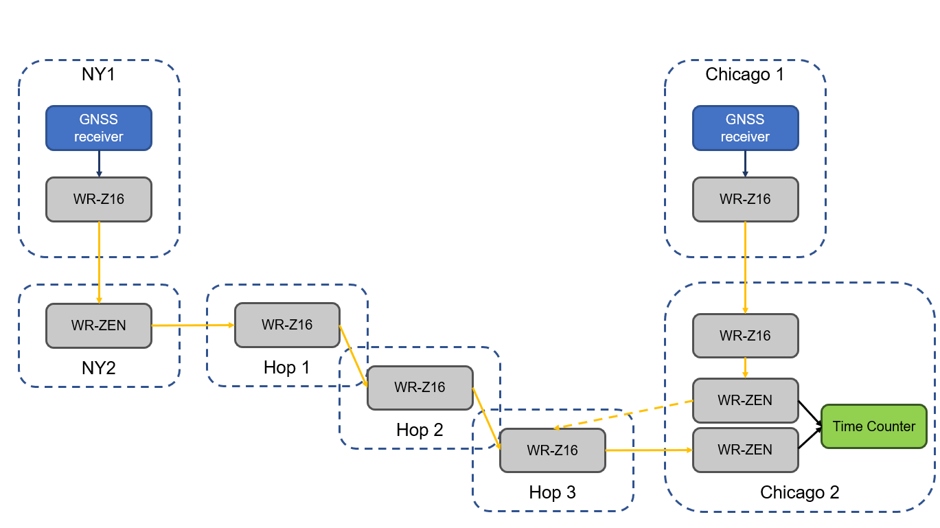
The White Rabbit link has an approximate distance of 1,350 km (840 miles) and was deployed in collaboration with Optiver U.S., a financial company, to connect Chicago and New Jersey trading locations. This link is formed by six long-distance White Rabbit hops using WR-Z16 and WR-ZEN TP devices connected by a combination of DWDM and SyncE-compliant transponders over a public telecommunication fiber network.
Seven Solutions is the leading company in the development and integration of high accuracy sub-nanosecond time transfer and frequency distribution for reliable industrial and scientific applications. Their technology integrates the White Rabbit protocol, the basis for the new high accuracy profile in the IEEE 1588-2019 (PTPv2.1).
This technology has become a reference for different sectors thanks to its unprecedented level of accuracy that outperforms current GNSS-based timing solutions, offering a suitable backup solution to deploy time dissemination networks. In the last few years, the White Rabbit technology has been adopted in the finance sector to deploy plug-and-play local area synchronization and metro-area links connecting different datacenters in financial hubs.
Although the performance of White Rabbit long distance links has been previously validated, this deployment sets a new distance record while integrating new resiliency and interoperability features using the latest WR-Z16 and the WR-ZEN TP devices.
Image: Seven Solutions
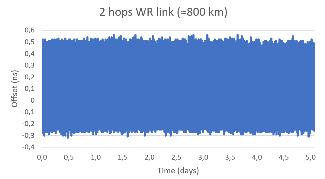
In a series of experiments, the link accuracy and precision were firstly validated setting a three long-distance hops loopback covering an approximate distance of 800 km (500 miles). In this case, the link was measured using an Agilent 53210A time interval counter for a five-day period. This experiment was intended to validate the feasibility of deploying White Rabbit links using commercial SyncE-compliant transponders and commercial telecommunication networks based on DWDM technologies.
Image: Seven Solutions
This measurement confirms the sub-nanosecond precision on a loopback and made it possible to perform network effect calibration to minimize the residual offset caused by the link asymmetry. In this case, a mean offset of 112 ps, a standard deviation equal to 139 ps and a peak-to-peak difference of 880 ps were obtained. Additionally, the offsets followed a gaussian distribution with no daily trends impacted by temperature or humidity.
This result proves the ability of high-accuracy time-over-fiber dissemination to fulfill the most demanding telecom requirements (class D Telecom Boundary Clocks) and corroborates one of the conclusions from the Analyzing a More Resilient National Positioning, Navigation, and Timing Capability report released by the RAND Corporation earlier this year:
“White Rabbit can support time transfer with accuracy that substantially exceeds the needs of almost all users; it is better than GPS. Therefore, this method is a strong candidate for backing up GPS time transfer for users that require atomic clock accuracy and for serving as a ‘national backbone’ for time so that secondary users, such as cellular networks, can perform to the limits of its own subdomain without suffering additional inaccuracies of its own master clock. Less accurate methods, like ordinary PTP, could provide timing to the vast number of other users, like mobile and cellular users.”
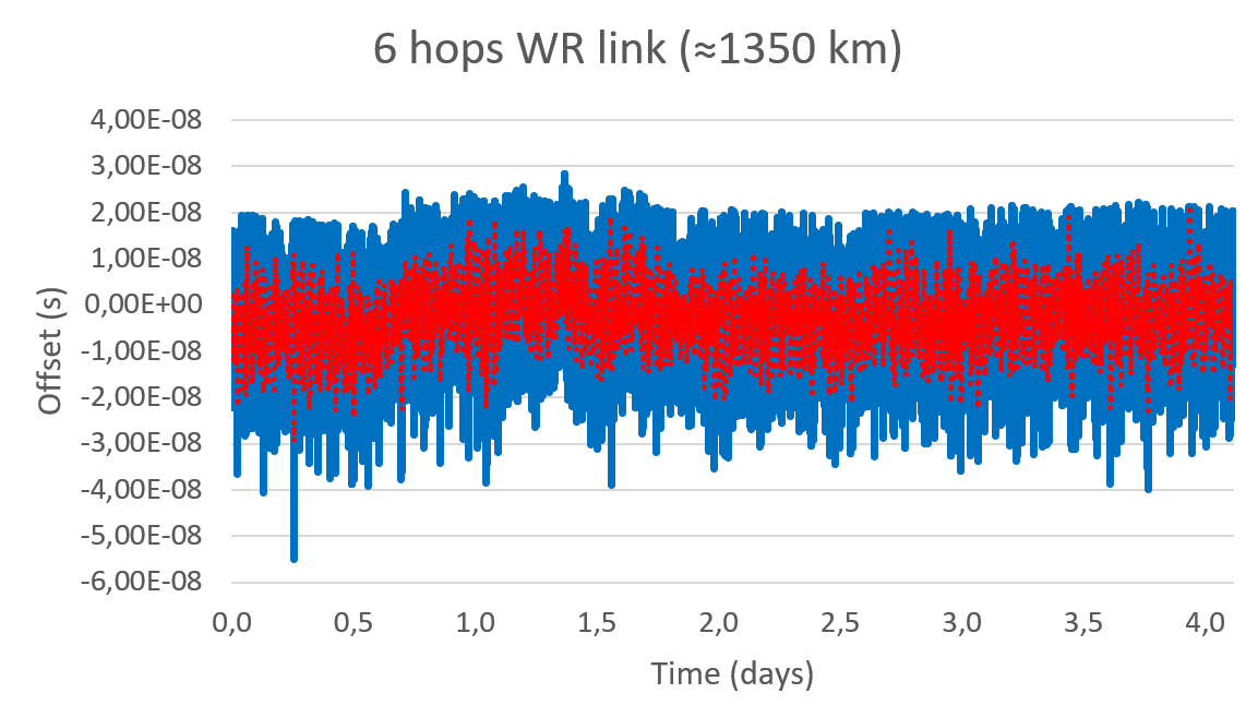
In a second test, the whole link was deployed using GNSS receivers in both ends of the link. The first GNSS receiver was used as the time reference in one end of the link (located in New Jersey) and the second GNSS receiver was used in the second end of the link to compare to the time reference (located in Chicago). Both GNSS receivers are the same model and have a 15 ns RMS jitter specification. In the second location, the local GNSS reference was compared to the remote time reference originating from New Jersey through the long-distance White Rabbit link.
Image: Seven Solutions
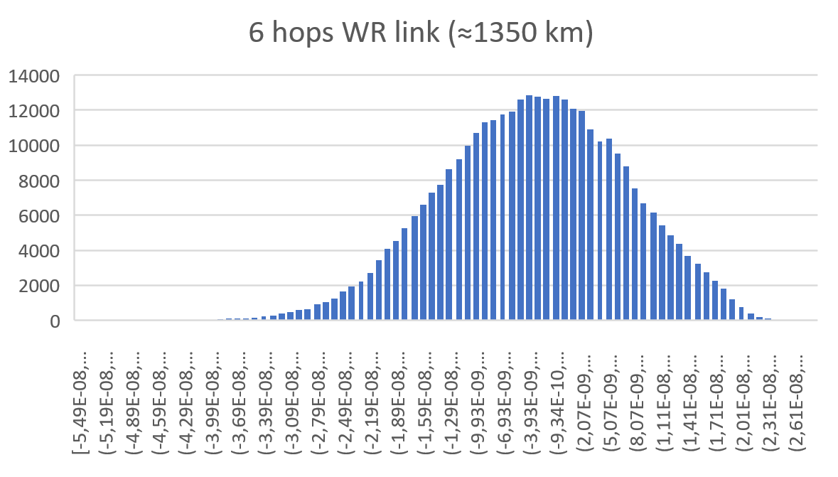
This resulted in a mean offset equal to 2.98 ns, a standard deviation equal to 10.4 ns and a peak-to-peak equal to 83.3 ns. It is noteworthy that due to the time interval counter, some of the samples were filtered. This effect is shown on the histogram but is considered negligible to validate the feasibility of the link.
Image: Seven Solutions
Additionally, the White Rabbit protocol automatically corrects daily effects due to temperature or humidity changes in the link, which are not observed in the measurement even when the GNSS receivers are located more than 1,000 km away from each other. This does not represent the real White Rabbit link error but indicates the limitation of using GNSS receiver to accurately measure the link accuracy.
As can be estimated from the measurements, the previous test and the GNSS specifications, the White Rabbit link maintains an approximately ±1 ns precision. In fact, the results show that the GNSS receivers are outperforming their specifications by almost 50%. The final accuracy is influenced by the GNSS receiver calibration. This link can be calibrated using network effect techniques (as shown in the previous experiment) or using the GNSS receivers themselves.
This experiment complements the results obtained in the U.S. Department of Transportation GPS backup demonstration showing the White Rabbit technology (which was catalogued as the most accurate alternative technology for time distribution) in a real telecommunications network scenario with very long distances. Additionally, it justifies the industrial need to deploy high accuracy time distribution when providing an alternative to GNSS-based timing, as it provides a next generation technology that can benefit other PNT systems and several critical infrastructures that rely on time synchronization for daily operations.
Beyond this, White Rabbit is demonstrated as a disruptive technology that can be used to measure the performance of GNSS in various locations to develop a warning and backup system, to connect high stability time references (for example, atomic clocks) for a suitable long-term ground-based backup to GNSS systems or to connect national metrology institutes around the world to compare different time scales.
This long-distance link represents a new milestone in ultra-accurate time transfer over existing telecom networks that allows cross-validating different linked references or accurately synchronizing them for coordinated actions at tight relative timing.
Furthermore, the deployment through existing telecom network proves its feasibility at affordable cost and opens the door to new disruptive applications. Atomic clocks have evolved to represent very stable references, but it has been typically assumed that time degrades as it is transferred over long distances making accurate comparisons between different references a challenge. This new generation of long-distance links represent a step further into tightly synchronizing different devices over fiber at long distances making them resilient to the vulnerabilities of GNSS timing.
This level of accuracy is key for certain applications and sectors nowadays. Matt Nassr, Data Engineering Lead at Optiver, remarked “Partnering with Seven Solutions has allowed us to better optimize for the highly distributed nature of the financial markets. Being able to establish a nanosecond-level precision link across the Chicago-New Jersey path further improves our ability to provide liquidity across the major US exchanges.”
“This is not a first step on the deployment of long-distance time synchronization networks, this is just one step further,” said Francisco Girela, Americas tech responsible at Seven Solutions. “We have been working for years on improving our devices, easing the monitoring and management, enhancing the resiliency, integrating failover features, adding interoperability with IEEE 1588 (PTP), NTP or PPS and allowing the integration of High Accuracy timing in third party devices thanks to the HATI core. During this journey we have learnt how to integrate the technology to work at its best and we have proved its effectiveness in telecom, data centers, finance, defense, or power grids among others.”
When asked about next steps, Francisco added, “We want to demystify this technology. People think that its deployment is complex or overkill, but that is not true. We see White Rabbit as the core technology to build alternative PNT systems, setting a sub-nanosecond timing foundation that will push the development of a more diverse and more accurate technology ecosystem.
“We have worked to evolve White Rabbit devices to be a market commodity when deploying time synchronization in local areas but providing a level of accuracy that will fulfill the requirements for the current applications and for the next decade. For long distances, complex deployments, or projects we are always happy to assist our customers and partners to get the best from our devices. We are sub-nanosecond natives; we care for every single picosecond.”
Coalition gives voice to PNT companies seeking open-market approach to backing up GPS/GNSS for critical infrastructure
Several GNSS and positioning, navigation and timing (PNT) companies have joined forces to create a new lobbying group, the Open PNT Industry Alliance. Founding companies include InfiniDome, Iridium Communications, Jackson Labs Technologies, NAVSYS Corporation, NextNav, OPNT, Orolia, Qulsar, Satelles and Seven Solutions.
In the United States, the coalition believes the Executive Order on “Strengthening National Resilience Through Responsible Use of Positioning, Navigation, and Timing Services,” issued in February 2020 begins the process for a national alternative PNT policy.
The report was criticized by some lawmakers for inaccuracies and lack of depth, but several companies whose solutions were referenced in the report defended it, and have now joined in creating this new alliance.
The alliance expects to support similar initiatives in other countries.
The coalition is designed to fortify economic and national security by supporting government efforts to accelerate the implementation of backup PNT capabilities for critical infrastructure. Other companies sharing these views are invited to join the alliance.
The Open PNT Industry Alliance will be introduced in an Orolia PNT Coffee Talk webinar on Thursday, Dec. 17, at 10 a.m. EST.
A serious problem facing nations around the world is that GPS and other GNSS are susceptible to inadvertent disruptions and deliberate attacks. Such incidents have the potential to impair or incapacitate communications networks, transportation systems, energy production and distribution platforms, financial services operations and other types of critical infrastructure.
With the scope, complexity and severity of disruptions and attacks evolving continuously, the combination of wide-ranging PNT solutions and emerging technologies offers superior protection to current threats by providing a backup to GPS/GNSS and improving national resilience.
“Multiple forms of alternative PNT deliver the broadest possible range of operational and performance characteristics to meet the diverse needs of applications across all industry sectors, plus they can better adapt to future threats than a single technology with its inherent vulnerabilities,” said Michael O’Connor, CEO of Satelles. “The mission of the Open PNT Industry Alliance is to promote open-market concepts that preserve industry’s long-term ability to harness its inventive talent to protect GPS/GNSS with multiple solutions that are technologically advanced, commercially viable, and based on a sustainable long-term funding framework.”
The Open PNT Industry Alliance will share its expertise with governments to aid their efforts to set policies, define regulations, and enact laws that achieve their national resilience objectives while preserving competition in the open market. A principal purpose of the coalition is to stimulate and capitalize on the collective intellect of industry in a collaboration between the public sector and private sector.
“The ingenuity of the private sector is spurred by competition and public and private investment, and this will drive the emergence of multiple GPS/GNSS alternatives that are cost-effective and evolve according to threat profiles, technological innovations, and market dynamics,” said Jean-Yves Courtois, CEO of Orolia. “Similarly, unbridled innovation will address new and still evolving use cases not supported by GPS/GNSS.”
The coalition will work closely with governments as they consider plans for regulation of critical infrastructure sectors and funding for alternative PNT. Legislators and policymakers can best pursue national interest through a multi-technology approach to PNT resilience, the coalition stated in a press release. The coalition will advocate for the establishment of a robust and self-sustaining funding framework that allows for the development and adoption of multiple sources of PNT that meet the needs of various sectors and industries.
“We believe a multi-technology approach to PNT resilience not only meets a more diverse set of critical infrastructure needs but also ensures a more robust approach to security by providing multi-layer resilience,” said Ganesh Pattabiraman, CEO of NextNav. “Delivering alternative PNT capabilities on an equal footing with GPS will require government policies and funding that ensure these solutions are cost-effective for critical infrastructure providers and sustainable over the long term.”
The U.S. Department of Homeland Security “did exactly what was required by Congress” in issuing its report in June on positioning, navigation and timing (PNT), according to a letter sent by numerous PNT companies to the DHS.
The July 17 letter to Chad F. Wolf, acting secretary of Homeland Security, refutes a previous letter from Congressional representatives that the report contained numerous errors and failed to address many of the things Congress had required.
“We believe that some key claims made in the members’ letter of June 9 are either exaggerated, irrelevant to the report’s Congressional tasking, or simply wrong,” states the July 17 letter, which is signed by senior executives of Satelles, Orolia, Iridium, Navsys, Jackson Labs, Seven Solutions and Qulsar.
The group takes on the claims of the representatives point by point, finding them exaggerated, irrelevant or incorrect.
For instance, the letter critical of the DHS report states:
“The report focuses on the needs of ‘industry’ largely ignoring the needs and impacts on public services (including first responders), government operations, and individual citizens.”
In response, the industry representatives state:
“The focus of the report, as directed by the NDAA, is on the requirements of the owners and operators of national critical infrastructure. This includes “public services, government operations,” and its beneficiaries, “individual citizens.” To the extent that the report focuses on incentivizing the industry, it is in order for it to be able to meet these requirements.
“While the report only highlights PNT use cases from a subset of the 16 critical infrastructure sectors, their pragmatic recommendations address a range of requirements across all sectors. With respect to PNT needs for backing up GPS, DHS acknowledges the differences between and commonalities among the sectors and offers exceptional guidance for leveraging the capabilities of diverse forms of commercially available alternative PNT rather than endorsing a single, anti-competitive, government-imposed solution.”
Orolia and Seven Solutions have partnered to deliver resilient, accurate, and stable time and frequency for global military, commercial and critical infrastructure applications.
According to the companies, the partnership will address the ultra-precise, resilient timing and frequency requirements of industries such as defense, aerospace, data centers, telecom, financial services, smart grids and other critical infrastructure.
Through the partnership, Orolia will offer a modular approach to resilient PNT, which includes a combination of GNSS signals protected with interference detection and mitigation technology, together with low Earth orbit secure alternative signals. The Orolia-Seven Solutions partnership also will offer terrestrial sub-nanosecond time distribution from distant and potentially redundant locations.
“This partnership is a key example of Orolia’s commitment to combining best-in-class technologies into more robust resilient PNT solutions for our customers,” said Orolia CEO Jean-Yves Courtois. “Those who require the most accurate, extremely precise time and frequency technology will now also benefit from an unprecedented level of resilience to protect critical PNT data sources, for more confidence and peace of mind.”
This new partnership between Seven Solutions and Orolia will facilitate global operations and naturally integrate with reliable time sources. Seven Solutions will focus on bringing the best-in-class time and frequency distribution, the companies said.
The U.S. Department of Transportation awarded contracts to 11 companies to demonstrate their technologies’ ability to act as a backup for GPS.
We wanted to know a bit more about what each of them were going to demonstrate, so we asked each for an explanation. Most provided just that, so much of what appears here is in their own words. A couple of companies sent us a whole lot more than 100 words and two did not respond. For those, we did our best with the materials they sent us and other publicly available materials.
Wi-Fi, Cellular, Ultra-Wideband
PhasorLab plans to demonstrate its Hyper Sync Net (HSN) technology as a backup to GPS-based PNT solutions. HSN is a self-organizing mobile mesh network capable of maintaining high-precision time (<<1 ns) and frequency (<<1 ppb) synchronization throughout the whole network as well as an instantaneous 3D locational map of the whole mesh network requiring as little as a single master reference node.
The HSN can be deployed either as a set of fixed reference nodes providing time and positioning references to other mobile UE clients, which is like a terrestrial version of GPS, or as a private ad-hoc mobile mesh network where all members are expected to be mobile.
Skyhook Technology’s system is powered by an immense database — created and maintained by Skyhook — that contains more than five billion geolocated access points and 200 million cell base station IDs, enabling it to accurately locate phones and devices worldwide. The user is not required to be connected to a Wi-Fi network for the system to work. The scan will simply detect Wi-Fi access points in the local area based on signals sent periodically (or on demand) according to the IEEE 802.11 specifications. Many devices will acquire information on as many as 100 access points in the surrounding area. Skyhook’s Wi-Fi positioning system (WPS) will compute an estimated end-user location based on each of the signal sources independently, and compute an optimal hybrid location estimate from all sources.
Fiber/Network
OPNT’s Global Terrestrial Timing Service (GTTS) provides GPS-independent timing-as-a-service over global fiber-based networks. Trading off cost versus service-level agreement (SLA)-backed accuracy, standard network connectivity offerings and bidirectional fibers are combined to meet application needs. As will be demonstrated with simulations of National Institute of Standards and Technology (NIST) and the two U.S. Naval Observatory (USNO) clocks, OPNT’s fully redundant solution receives its core Coordinated Universal Time (UTC) timing directly from the non-maskable interrupts (NMIs).
The demonstration will include sub-nanosecond stability with fault detection and glitchless recovery. Using the precision-timed fiber base, OPNT will also demonstrate precision monitoring of wireless signals with continuous, real-time corrections to keep the wireless transmissions and its local timing source in sync.
Seven Solutions’ core technology is called White Rabbit and was born at CERN. In this demonstration, Seven Solutions plans to showcase the performance of this technology, both on local and wide-area deployments, and explain the capabilities in terms of interoperability (integrating multiple synchronization technologies, i.e. IEEE 1588 PTP, NTP, PPS, 10-MHz clocks), scalability and resiliency. The goal is to provide a reference technology that can provide very stable time references over fiber in GPS-denied scenarios as a backup source or to complement other PNT solutions that need timing distribution at their core.
eLoran
Hellen Systems’ team said it is excited by its recent contract award to perform a GPS back-up demonstration for the Department of Transportation. Its team plans to demonstrate advanced eLoran technologies and offer resilient PNT services. Its next-generation solution will include a solid-state eLoran transmitter from Continental Electronics Corp. integrated with advanced timing and frequency products from Microsemi, a Microchip company. Hellen Systems also plans to deploy its proprietary receiver and reference systems developed by Microsemi.
Hellen Systems and program integrator L3Harris will manage the demonstration, with Booz Allen Hamilton providing technical and engineering leadership.
UrsaNav supplies eLoran, LFPhoenix and low-frequency technology for very wide-area, GPS-independent, PNT data and frequency services. UrsaNav was selected by the Volpe Center to demonstrate wide-area UTC time synchronization and distribution utilizing the former Loran site in Wildwood, New Jersey. UrsaNav will provide innovative new eLoran technology at the site in Wildwood to broadcast a UTC-synchronized eLoran signal. The demonstration will be conducted at one of the Volpe Center demonstration sites at Joint Base Cape Cod in Massachusetts or the Langley Research Center in Langley, Virginia. Either site can be utilized in the demonstration as eLoran signal transmissions from the Wildwood site can easily cover 700 miles or more.
Serco recently acquired Alion’s Naval Systems Business unit. This included a group working in New London, Connecticut, that has previously worked with and published on eLoran. While we did not get a response from Serco to our inquiry, eLoran is likely the technology the company will demonstrate.
Satellite
Globalstar-Echo Ridge’s system is based on Augmented Positioning System (APS) technology that uses ordinary signals from communications satellites (not special positioning/navigation signals, such as those from GPS satellites) to produce accurate position and timing information in compatible user devices. No new infrastructure is needed; Globalstar’s constellation of 24 low-Earth-orbit (LEO) satellites and Echo Ridge software and compatible devices at the user end provide the building blocks for the APS-based system. APS technology has been successfully demonstrated in diverse environments and incorporates multiple features to assure accurate PNT information under circumstances that can challenge or disable GPS/GNSS technology.
Satelles provides unique timing and location solutions delivered over the Iridium constellation of 66 LEO satellites. These timing and location signals are available anywhere on Earth without the need for local infrastructure, making the system perfect for complementing GPS and other location-based technologies.
Unlike standard GPS, these high-power signals can reach into many building structures. Most importantly, Satelles has customized the Iridium signal-in-space to provide a location-specific signature that can reliably prove (or authenticate) the location of a mobile device or other equipment, while being virtually impervious to spoofing and other attacks.
TRX Systems’ NEON Personnel Tracker provides ubiquitous 3D location, tracking and mapping. (Screenshot: TRX Systems)
Other
TRX Systems is the developer of NEON GPS-denied location solutions, delivering 3D location and mapping for dismount personnel where GPS is not available or is unreliable — including indoors, underground, in dense urban areas, and where GPS is found to be erroneous. NEON delivers ubiquitous, low-cost, GPS-denied location by using advanced sensor fusion, ranging and patented dynamic mapping algorithms that improve safety and situational awareness for military, public safety and industrial personnel.
NextNav’s Metropolitan Beacon System (MBS) is a 3GPP-compliant, terrestrial network of long-range broadcast beacons, transmitting a “GPS-like” signal in licensed spectrum in the sub-GHz range. The combination of an on-board atomic clock and the ability to self-synchronize allows the system to operate independent of GPS and provide full PNT services in its footprint. The ability to integrate the MBS signal in mass-market GPS and LTE chipsets can provide a seamless ability to provide full PNT services in the presence and absence of GPS. Because of its terrestrial nature, MBS is able to work indoors, in urban environments and outdoors; for barometer-equipped devices, MBS also enables floor-level altitude determination.