Tag: sewer

  • Eos releases underground infrastructure mapping solution for Collector for ArcGIS

    Eos releases underground infrastructure mapping solution for Collector for ArcGIS

    Eos Locate for Collector for ArcGIS enables utilities to map buried assets with submeter or centimeter accuracy

    A worker using an Arrow receiver and vLoc from Vivax Metrotech. (Photo: Eos Positioning)
    A worker using an Arrow receiver and vLoc from Vivax Metrotech. (Photo: Eos Positioning)

    Eos Positioning Systems Inc.  (Eos) has released its underground utility asset-mapping solution: Eos Locate for Collector for ArcGIS.

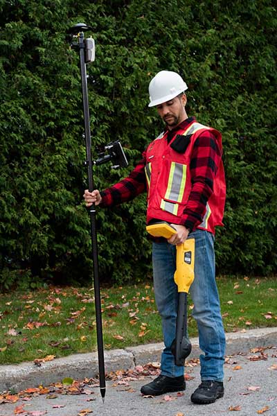
    Eos Locate for Collector combines three core technologies: Eos Arrow GNSS receivers, Esri Collector, and the Vivax-Metrotech vLoc Series of locator devices.

    With Eos Locate for Collector, one field worker can collect both GNSS locations and locator data (such as depth below cover) for any buried asset including water, sewer, electric, cable, gas, fiber infrastructure and more. They can do so quickly, accurately and without the need for any additional field or office support.

    “We are giving our Arrow GNSS customers a solution today that allows them to combine both locator data and high-accuracy locations in web maps,” Eos CTO Jean-Yves Lauture said. “This greatly simplifies their workflow by allowing one person to do underground locates and GIS mapping simultaneously.”

    “This is a big step forward for utility organizations who need to gain better visibility of their infrastructure,” said Doug Morgenthaler, Esri program manager. “With today’s technology, utilities can already see where new assets are being put in the ground. The challenge historically has been figuring out where existing assets are.”

    Eos Locate for Collector not only streamlines underground-asset mapping, but also improves office production times. It eliminates the need to manually combine datasets from the locator and GPS devices within ArcGIS.

    “Seeing all that information from utility locators and GPS receivers packaged directly into a GIS application is exceptional,” Vivax-Metrotech Eastern Regional Sales Manager Kelvin Cherrington said. “This solution will help utilities create maps of their underground assets with a much more modern and efficient methodology.”

    Indiana American Water Early Adoption

    Earlier this year, Indiana American Water approached Eos to seek a solution that consolidated their utility-locate workflow with their Arrow and Collector field work.

    “We had the manpower to put paint down,” said Todd Chapman, Indiana American Water Senior GIS Analyst. “But we would need to hire another person to map the locations with our Arrow Gold GNSS receivers.”

    Chapman estimates Eos Locate for Collector will cut their field time in half as well as enable the creation of extremely accurate buried-infrastructure maps in ArcGIS.

    “Previously, we were seeing that our old water mains could be off by up to 20 feet,” Chapman said. “With the new Eos Locate for Collector, we’re seeing that it’s accurate to under an inch.”

    The initial release of Eos Locate for Collector runs on Apple’s iOS iPhones and iPads and supports the vLoc Series from Vivax Metrotech. Future releases of Eos Locate for Collector will support additional locator models including the vScan series.

    With accurate digital twins of their buried infrastructure, utilities across sectors can expect improvements to safety, damage prevention, field efficiency and regulatory compliance.

    “Not only does this mean quicker responses to 811 tickets and fewer liabilities during field digs,” Lauture said. “But it also constitutes a major step forward toward the highly efficient future of 3D asset management and viable augmented-reality workflows.”

  • Bentley Systems offers new sewer and stormwater products


    StormCAD from within OpenRoads.
    StormCAD from within OpenRoads.

    Bentley Systems’ latest infrastructure products are now available. They include SewerGEMS, SewerCAD, StormCAD and CivilStorm V8i (SELECTseries 5) products for the analysis and design of wastewater and stormwater systems. All of the V8i (SELECTseries 5) sewer and stormwater products can be used as stand-alone products, or be run on CAD and GIS platforms.

    They can also now be used from within the V8i (SELECTseries 4) versions of OpenRoads-based products — combining 3D design and hydraulic analysis capabilities in the same platform. The resulting comprehensive civil solution eliminates the need for extra import/export steps or file conversions, Bentley Systems said.

    “The integration of Bentley’s OpenRoads civil design functionality with the advanced capabilities of Bentley’s storm and sewer analysis products will be a huge benefit to productivity and quality for our highway drainage design workflows,” said Chris Haines, senior civil engineer and PAR-BIM technical lead, Drainage and Utilities, Parsons.

    Terrain model elevations on profiles.
    Terrain model elevations on profiles.

    “With these new releases, the automated hydraulic design functionality of our sewer and storm products can be effortlessly combined with the 3D physical design and terrain modeling capabilities of Bentley’s other civil products,” said Gregg Herrin, Bentley Systems director of product management, hydraulics and hydrology. “From an information mobility standpoint, this has a direct and substantial positive impact on roadway, site and municipal work where hydraulic engineering is just one part of a much larger project.”

    Bentley’s SewerGEMS, SewerCAD, StormCAD and CivilStorm V8i (SELECTseries 5) products provide the following capabilities:

    • Ground elevations from terrain models may be used during automated design runs to consider “cover” along a pipe’s length, improving decision making related to system design.
    • Terrain model elevations can also now be added to profiles, improving the resulting visualization and the user’s understanding of the physical network.
    • New low-impact development (LID) elements are now available, making it easier to model a wider range of controls for stormwater management.
    • With the new lateral link element, engineers can include lateral pipes in their hydraulic analysis without creating “fake” elements where the laterals connect to the main pipe.
    • Easy access to the Bentley Communities professional networking site is embedded within the applications, facilitating communications between users and Bentley’s hydraulic modeling experts.

    Users of any of these SELECTseries 5 releases now benefit from the products’ support of MicroStation V8i (SELECTseries 3), OpenRoads V8i (SELECTseries 4), AutoCAD 2015 and 2016, and ArcGIS 10.2 and 10.3 (SewerGEMS only), giving them the ability to model from within the latest MicroStation, OpenRoads, AutoCAD or ArcGIS version.