Of it all. Of the broad expanse of the world and all its inhabitants, its layers, its depths and heights, the atmospheric mantle in which it wraps itself, its floating mountains of ice and its solid soaring peaks of rock and snow, its savage predators, and all its shades of human endeavor.
Every August we marvel at the many applications of global positioning science, at real-world instances of hardware and software in the service of humankind and of Gaia itself.
Eleven months out of the year we chronicle the business and technology of GNSS, as it says on the cover. Eleven months we busy ourselves with explorations of R&D, of novel concepts and experimental tests, of integration and augmentation and propagation and limitation and innovation; of algorithms and systems, theorems and OEMs, robotics and aeronautics, UAVs and degrees, integrity and capability and availability and mobility and connectivity and security, functionality and ambiguity and compatibility and velocity and linearity.
Every once in a while we have to stop amid all this admittedly somewhat abstruse science and ask ourselves: “GNSS — what is it good for?”
Answers are never lacking. Since Ivan Getting originated the idea of lighthouses in the sky for humanity in the 1960s, inventors have put forward new solutions for vexing problems — sometimes solutions for what we didn’t know was a problem, but upon investigation turns out to have a profitable resolution. Witness the stories in this issue, from sharks to space, from mountaintops to multi-sensor navigation under interference or heavy canopy.
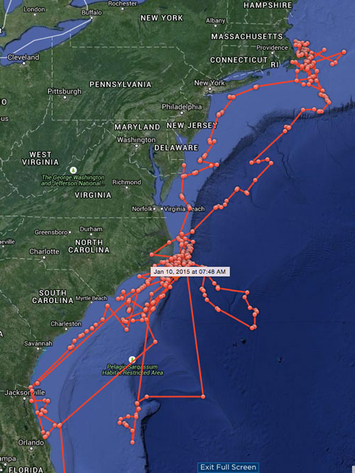
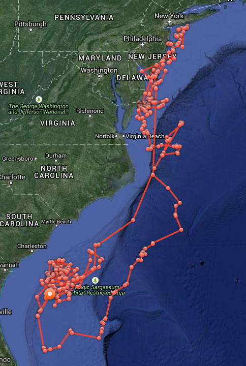
Now about those sharks. In case you were wondering whether Katharine or Mary Lee might have been culpable in the seven shark bitings off North Carolina during May and June — they were not. The maps here and their GPS timelogs give both solid alibis for all the attacks in question.
Katharine’s cruising over the past year.Mary Lee’s meandering over same time.
Global Tracking Project Demystifies the Ocean’s Top Predators
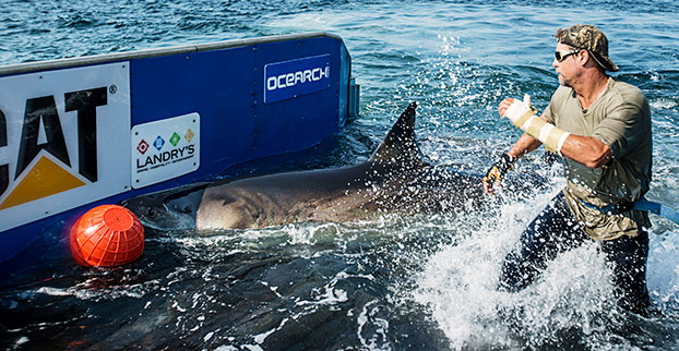
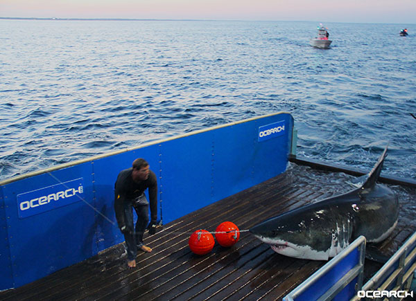
Chris Fischer helps tag Katharine, a 14-foot 2-inch, 2,300-pound great white, on Sept. 17, 2012. Katherine cruises the East Coast of the United States. (Photo: OCEARCH)
By Tracy Cozzens Photos courtesy of OCEARCH / R. Snow
Where are sharks? What are their migratory patterns? And how close do they come to shore? Until recently, the life cycle of sharks has been a mystery. The nonprofit OCEARCH is tagging and tracking a variety of sharks, and sharing the data with scientists around the world.
OCEARCH’s Global Shark Tracker app.
Since 2007, OCEARCH has tagged a total of 200 sharks, including 80 great whites, 80 tiger sharks and a few smaller species. About 50 tags are actively sending data to a publicly available shark tracker, also accessible with an iOS and Android app. OCEARCH also has popular Twitter feeds and Facebook pages for its most famous sharks, and Mary Lee (@MaryLeeShark, 86,100 followers) and Katherine (@Shark_Katharine, 32,300 followers). The access has changed the conversation from fear of a shark interaction to curiosity about their movements and life cycles, explained OCEARCH Founder Chris Fischer.
Before the shark tracking project, “We lacked the critical data on our large apex predators’ life history. We didn’t understand where they were mating, where they were giving birth, and these large complicated migrations that they make,” Fischer said.
Pulling a great white shark from the water long enough to tag it was a daunting hurdle that OCEARCH overcame by bringing together professional mariners, ocean experts and the academic community to solve the problem. The answer is a hydraulic lift system designed for shark tagging installed on the M/V OCEARCH research vessel. Once a shark is on the line, it’s maneuvered into a custom hydrauic lift. The 75,000-pound-capacity platform is designed to safely lift mature sharks for access by a multi-disciplined research team, who rush to conduct about 12 studies within 15 minutes before setting the shark free. The shark is guided by hand in the water on and off the lift.
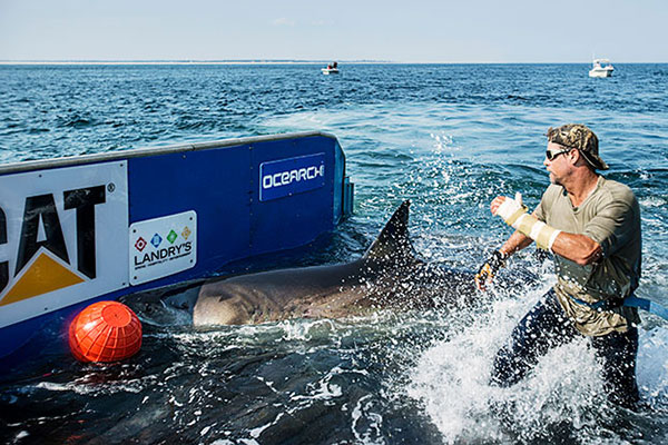
This hydraulic lift allows scientists to pull in and tag a live mature shark, in this case Mary Lee.
Once OCEARCH figured out how to capture and tag the sharks, the organization invited multiple institutions to share the data. “We decided to open source the data and give the tracking data away so that the world could track the sharks and be involved in the project at the same time as the Ph.D.s. And that’s where the Global Shark Tracker really came about: it was including the world in solving this puzzle in real time in this journey.”
The M/V OCEARCH now travels around the globe “to help the scientists who study our ocean’s giants explode their knowledge forward as fast as we can,” Fischer said. “So we have the critical data we need to keep these balance-keepers, these lions of the ocean, our large sharks with a bright future.”
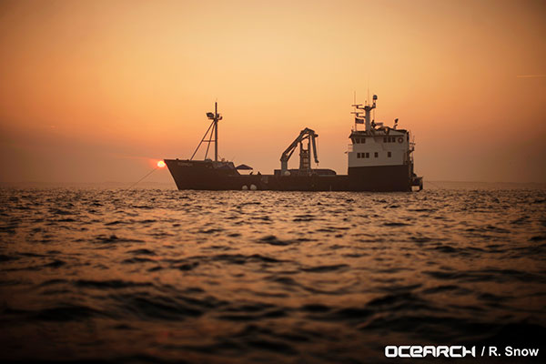
Research expeditions are conducted worldwide aboard the M/V OCEARCH, which serves as both a mothership and at-sea laboratory.
The long-term goal is gaining a clear picture of the sharks’ needs, so that the oceans can be properly managed. “They’re the fundamental building block of the future of the ocean. If we don’t understand our apex predators, the top of the food chain, if we don’t understand how to manage them toward abundance, then we can’t manage the whole system toward abundance,” Fischer said.
More than 50 of the world’s leading institutions and more than 80 ocean scientists are involved collaborating and sharing data, a different paradigm from the classic way researchers work. “We realized quickly the old institutional way of researchers holding their data close to the vest and not sharing it with the world, trying to get ahead of one another to get papers published, wasn’t really effective for creating a movement and awareness around the future of the ocean at scale,” Fischer said.
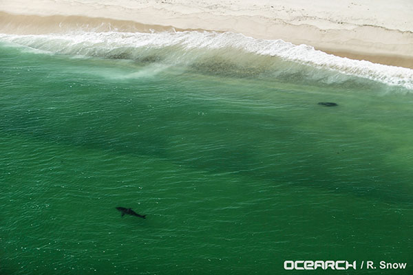
Great White shark Katherine spotted by plane before being captured and tagged.
Information on where and when sharks swim and migrate can be leveraged for public safety, Fischer said. “Once we solve the puzzle of the migrations, the sharks then repeat the migrations to the same areas at the same times of the year. It allows people to get the rhythm of their lives and understand when they’re passing through their areas, and when they’re there and when they’re not.”
The sharks are tagged accelerometers, and with SPOT trackers from Wildlife Computers (short for Smart Position and Temperature Tag). Data from the accelerometers show that the animals regularly recover and start swimming strongly within 2–4 hours after release. Data from the Global Shark Tracker provides strong evidence that the animals tagged show long-term survival and long-distance migrations indicative of normal function and reproductive cycles, according to OCEARCH.
A SPOT tracker (top) and an accelerometer are attached to Mary Lee’s dorsal fin.
SPOT tags are designed to function in salt water. The tag is mounted on a shark’s dorsal fin and provides location data when a shark’s fin breaks the surface for at least 90 seconds. The five-year battery life of the trackers has helped scientists decipher the sharks’ three-year migratory loops. After that time, the sharks tend to shed the trackers. “We just borrow that access for five years, to solve the puzzle and collect the data,” Fischer said.
The data from OCEARCH has revealed that sharks come right to shore, into the breakwater, more often than most people thought. Also, their range is much bigger than expected, with some juvenile sharks discovered migrating all the way from Cape Cod to New Orleans.
Lifeguards in the United States are testing how drones may help save lives in coastal waters. Cameras on drones can spot sharks from above, and drones are able to reach struggling swimmers faster than lifeguards to deliver life preservers.
In Seal Beach, Calif., lifeguards are using the flying device to monitor sharks. “It’s an extremely valuable tool for our water observation,” said Joe Bailey, chief of Seal Beach’s Marine Safety and Lifeguard Department, told the Los Angeles Times. The Seal Beach Marine Safety Department purchased a DJI Phantom 3 drone to monitor sharks off the coast. Safety officials fly the device at least twice a week to track juvenile great white sharks.
Meanwhile, lifeguards in Long Branch, N.J., are testing using drones to get life preservers out to swimmers in the ocean faster than a lifeguard could reach them. It would not replace the rescue work done by lifeguards in the water, however, who would still swim or row out to a victim. But it would buy a struggling swimmer extra time.
The Phantom 3 in flight at a press event.
“This is not to cut back on any lifeguards. This is a lifeguard’s tool to help move them along a lot faster in making the save, getting a life preserver out to a person,” said Michael Sirianni, president of the Long Branch City Council, told the Asbury Park Press.
The drones would be especially helpful when conditions are extreme, such as big surf and high winds that make it difficult to reach someone stranded. The drones could fly out a mile or two to reach distressed stand-up paddle boarders, kite surfers or capsized boats. Its camera could help locate submerged persons quicker, while microphones and speakers could enable lifeguards to talk to a person in the water.