Tag: Sharper Shape

  • Launchpad: RTK modules, inertial sensors

    Launchpad: RTK modules, inertial sensors

    OEM

    RTK and Heading Module

    Positioning and attitude determination

    Image: Unicore
    Image: Unicore

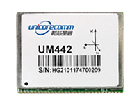
    The UM442 can simultaneously track GPS, BDS, GLONASS and Galileo. It also supports SBAS and QZSS. It uses Uncore’s new-generation Nebulas II chip and UGypsophila real-time kinematic (RTK) algorithm. Based on high-performance data-sharing technology and the simplified operation system of the Nebulas II chip, the UGypsophila RTK algorithm dramatically optimizes matrix processing, enabling the UM442 to track more satellites and shorten the initialization time to 5 seconds.

    Unicore Communications, www.unicorecomm.com

    Inertial sensors

    Designed for dynamic inclination and positioning

    Image: Lord Sensing
    Image: Lord Sensing

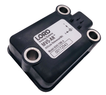
    The MV5-AR inertial sensors are designed for off-highway and military vehicles, marine and mobile robot applications, and the autonomous vehicle market. The rugged, compact sensors use LORD’s fifth-generation high-performance industrial-grade solid-state six-degrees-of-freedom (6-DOF) micro-electromechanical accelerometer and gyro inertial sensor technology. Successfully deployed on ground robots and heavy machinery, applications also include autosteer and terrain compensation; dynamic incline detection (roll, pitch, rotation); vehicle stability and leveling; platform control, alignment and stabilization; operator feedback; and precision navigation. The compact and rugged reinforced housing is fully sealed for immersion and pressure wash. Each sensor is calibrated and temperature compensated.

    LORD Sensing Microstrain, microstrain.com

    BeiDou upgrade

    GNSS simulators ready for 2020

    Spirent's GSS7000 test system. (Image: Spirent)
    Spirent’s GSS7000 test system. (Image: Spirent)

    BeiDou Phase 3 signals are now available on Spirent GNSS RF constellation simulators GSS7000 and GSS9000 — existing users can obtain the software upgrade by contacting Spirent. Phase 3 of the Chinese BeiDou system will extend its coverage from Asia to the entire world, providing receiver developers and integrators with additional GNSS signals to make positioning, navigation and timing systems more accurate, and help to support new applications, such as autonomous vehicles. Customers can test their designs before the system is fully operational in 2020.

    Spirent Communications, www.spirent.com

    High-precision module

    Based on u-blox F9 technology

    Image: u-blox
    Image: u-blox

    The ZED-F9P multi-band GNSS module has integrated multi-band real-time kinematic (RTK) technology for machine control, ground robotic vehicles and high-precision unmanned aerial vehicles applications. It measures 22 x 17 x 2.4 millimeters and uses technology from the u‑blox F9 platform to deliver robust high-precision positioning performance in seconds. The ZED-F9P is a mass-market multi-band receiver that concurrently uses GNSS signals from all four GNSS constellations (GPS, GLONASS, Galileo and BeiDou). Combining GNSS signals from multiple frequency bands (L1/L2/L5) and RTK technology lets the ZED‑F9P achieve centimeter-level accuracy in seconds.

    u-blox, u-blox.com

    Chip-scale atomic clock

    Ready for space

    Image: Microsemi
    Image: Microsemi

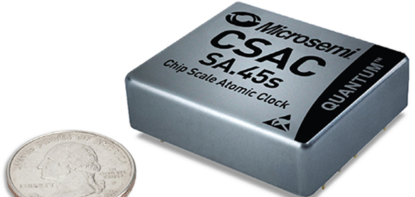
    The SA.45s Commercial Space Chip-Scale Atomic Clock (CSAC) is a commercially available radiation-tolerant CSAC suitable for low Earth orbit (LEO) applications. The device provides the accuracy and stability of atomic clock technology while achieving significant breakthroughs in reduced size, weight and power consumption. It provides excellent drift performance and built-in 1 pulse per second (PPS) input for GPS disciplining, making the device well-suited for holdover applications. Commercial and research space applications include satellite timing and frequency control; satellite cross linking; assured position, navigation and timing; and Earth observation.

    Microsemi, microsemi.com


    SURVEY & MAPPING

    Radio modem

    For heavy-duty RTK applications

    Image: Harxon
    Image: Harxon

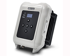
    The long-range, power-efficient eRadio is designed to support high-precision GNSS real-time kinematic (RTK) applications in surveying and precision agriculture. It is enabled with intelligent serial baud rate identification for different RTK devices. It can automatically identify RTK serial baud rate with a radio data cable and provide a plug-and-play form for easy connection between the eRadio and RTK. With its high transmitting power (5-35 Watts), transmission data can be up to 19200 bps/s over a connection distance of 50–80 kilometers. It can work as either a base or repeater with other Harxon radio modems in challenging environments.

    Harxon, harxon.com

    GNSS receiver

    Wireless communication with any Android or Windows terminal

    Image: SXblue/Geneq
    Image: SXblue/Geneq

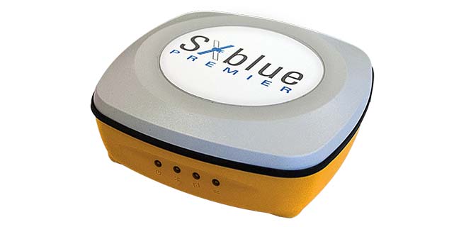
    The SXblue Premier GNSS receiver is available in a submetric version (GNSS) or centimetric version (RTK). It is equipped with Pacific Crest Maxwell 6 Trimble technology with BD910 (GNSS version) and BD930 (RTK version) OEM boards, delivering 220 channels to acquire and track GNSS signals from all constellations in view. It makes effective use of GPS, GLONASS, Galileo, BeiDou, QZSS and SBAS signals for precise positioning.

    SXblue, www.sxbluegps.com
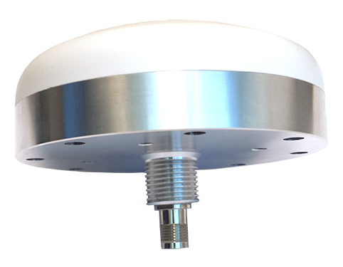
    Smart antennas

    With integrated Atlas L-band

    Image: Hemisphere GNSS
    Image: Hemisphere GNSS

    The single-frequency, multi-GNSS Vector V123 and V133 all-in-one smart antennas are multi-GNSS compass systems using GPS, GLONASS, BeiDou, Galileo and QZSS for simultaneous tracking for heading, position, heave, pitch and roll. Both support NMEA 0183 and NMEA 2000. The V123 and V133 thrive in radar/ARPA, AIS, ECDIS, side-scan survey, multi- and single-beam surveys, dredging and general navigation applications.

    Hemisphere GNSS, hemispheregnss.com


    TRANSPORTATION

    Mobile GPS tracker

    For tracking vehicles, assets and people

    Images: Trak4
    Images: Trak4

    The Trak4 provides GPS tracking with cell-trilateration fallback. Ping rates can be selected from every two minutes to once a day, with email and text alerts provided for geozone entry and exit or if the high-capacity rechargable battery is low (the battery runs up to 12 months on a single charge.) The Trak4 is designed for tracking vehicles, assets and inventory; it can also be used to track people such as the elderly. Indoor/outdoor weatherproofing allows “anywhere” mounting.

    Trak-4, trak-4.com

    Multi-GNSS antennas

    For positive train control

    Image: PCTEL
    Image: PCTEL

    PCTEL’s multi-GNSS L1/L2/L5 antennas combine aerospace-level precision with global satellite compatibility in a highly durable package. They enable critical applications including vehicular automation, 5G network timing synchronization and Positive Train Control (PTC) systems. The antennas increase the accuracy of timing and location information by providing simultaneous access to multiple GNSS signals across multiple frequency bands. The antennas support all relevant GPS, GLONASS, BeiDou and Galileo frequencies with excellent multipath mitigation and high out-of-band rejection for greater signal clarity. Their robust AAR and IP67-compliant design makes them suitable for years of use on railways and in other harsh real-world environments.

    PCTEL, pctel.com

    Off-Road GPS

    New range for walking and cycling

    Image: Ordnance Survey
    Image: Ordnance Survey

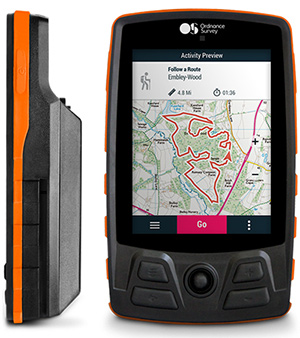
    Four new GPS handhelds are designed for off-road use, with safety in mind. All four of the OS GPS models have a built-in SIM card with access to the SeeMe subscription-based service and its safety features. With I.C.E (In Case of Emergency), users can send emergency alerts with exact coordinates to family and friends directly from the OS GPS. Live Tracking enables the user to be locatable at all times, sharing location and performance data with up to 20 friends in real time. Aventura, the most advanced navigation device, can be used in all weather conditions.

    Ordnance Survey, ordnancesurvey.co.uk

    Fleet management

    Real-time GPS fleet tracking

    Image: Zubie
    Image: Zubie

    Zubie Fleet Connect provides real-time GPS fleet tracking, driver check-in and performance reports, and vehicle health alerts. The monitoring and reporting service lets managers of fleets from 2 to 5,000 vehicles optimize business on the road. Wi-Fi connection to the cloud delivers important information about the health and performance of the vehicle, enhancing driver safety. Zubie also works with large enterprises to develop custom data flows and access driving data that can be used to analyze driving patterns, spot geographical trends in activity, or improve fleet asset management based on vehicle wear and tear.

    Zubie, zubie.com

    Multi-sensor payload

    Utility inspections with manned helicopters

    Image: Sharper Shape
    Image: Sharper Shape

    The Heliscope 2.0 provides onboard data collection with speed, efficiency and productivity improvements for the utility inspection industry. It provides a solution for operations over greater distances or in harsher environments than drones can accommodate The system integrates multiple sensor systems into a single, lightweight helicopter payload, capable of simultaneously collecting a range of data types required for utility maintenance and vegetation management inspections. Deployment enables optimized inspection and maintenance schedules, offering potential cost savings in those operational activities by as much as 50 percent. The Heliscope 2.0 has flexible mounting configurations and the ability to adapt for mounting on many different helicopter types.

    Sharper Shape, sharpershape.com


    UAV

    Survey system

    Accurate, quick aerial surveys

    Image: Aibot
    Image: Aibot

    Based on DJI’s M600 Pro platform, the Leica Aibot system is designed to rapidly and autonomously enable digitizing of critical infrastructure. It enables users to get a complete data set quickly with a user-friendly interface. Using Leica Infinity for point-cloud, digital surface model and orthophoto generation enables surveyors to process and visualize aerial data. For construction projects, Aibot provides access to critical information to perform volume calculations and monitor site progress. Users can see high-definition imagery and 3D mapping of the site and document progress. The UAV data can be combined with other survey technologies such as GPS for a more complete set of information.

    Leica Geosystems, leica-geosystems.com

    UAV antenna

    GPS L1/L2 + GLONASS G1/G2

    Image: Tallysman
    Image: Tallysman

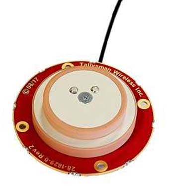
    Two lightweight, compact antennas are designed for UAVs with a low aerodynamic profile. Antenna model TW1829 is for original equipment manufacturers (OEMs), and model TW8829 is a housed version. Accutenna technology provides high-level rejection of multipath signals, a phase linear response and tight phase-center variations. Pre-filters prevent saturation of the front-end low noise amplifier by strong near frequency and harmonic signals.

    Tallysman, www.tallysman.com

    GNSS Antenna

    Multi-GNSS, multi-frequency four-heliX UAV antenna

    Image: Hemisphere GNSS
    Image: Hemisphere GNSS

    The HA32 high-performance antenna supports GPS, GLONASS, Galileo, BeiDou and Hemisphere’s Atlas L-band correction service. It is designed for UAVs, geographic information systems (GIS), surveying, real-time kinematic (RTK) and other applications requiring high-precision positioning and navigation. The HA32 is built on a proprietary four-helix antenna technology that provides superior filtering and anti-jamming performance with features such as a low noise figure of 2.0 dB (typical) and up to 30-dB gain (typical). Suitable for most outdoor and harsh operating environments, the HA32 antenna is sealed in a durable and ruggedized IP67-rated. The lightweight (40 g, typical), compact form factor (40 x 75 mm) makes it resistant to wind when on UAVs.

    Hemisphere GNSS, hemispheregnss.com

  • Sharper Shape introduces multi-sensor payload for manned helicopters

    Sharper Shape, a provider of unmanned aerial utility inspection solutions, has released the Heliscope 2.0, an onboard payload system that expands the company’s aerial sensing portfolio into the manned helicopter industry.

    According to the company, the Heliscope 2.0 integrates multiple sensor systems into a single, lightweight helicopter payload, capable of simultaneously collecting a range of data types required for utility maintenance and vegetation management inspections.

    Deployment of the Heliscope 2.0 enables optimized inspection and maintenance schedules, offering potential cost savings in those operational activities by as much as 50 percent.

    The Heliscope 2.0 also stands out with its flexible mounting configurations and ability to adapt for mounting on many different helicopter types.

    For example, the system can be mounted on most Bell Jet/Long Ranger helicopters using its FAA-approved nose mount, or attached to numerous other typical helicopter models using its unique Glider aerodynamic sled.

    The U.S. Federal Aviation Administration (FAA) permits mounting the Heliscope 2.0 to helicopters by using the cargo hook found on many helicopter models; this user-friendly method is approved by FAA under a classification for gliders.

    “While drones are a very flexible and safe method for performing utility inspections, there are situations where manned helicopters are the preferred vehicle to host sensors during certain utility inspections,” said Mikko Saarisalo, Sharper Shape’s vice president of drones and project lead for the Heliscope 2.0 project. “The new Heliscope 2.0 provides a solution for those situations where we need to operate over greater distances or in harsher environments than the drones can easily accommodate. This system takes our data harvesting efficiency and productivity up to a level unprecedented in the industry.”

    CORE includes algorithms to automatically analyze lidar point clouds and quickly generate utility vegetation management reports. Further, its unique automatic issue detection (AID) machine vision software uses artificial intelligence (AI) to eliminate the daunting task of performing frame-by-frame image data inspection, allowing personnel to focus on other aspects of inspection compliance.

    CORE applications work equally well with either Sharper Shape’s proven unmanned aerial inspection services, or with the new Heliscope 2.0 manned aircraft solution.

    “The fact that the Heliscope 2.0 integrates fully with our CORE software suite is a huge benefit,” said Sharper Shape CEO Ilkka Hiidenheimo. “We can collect all the key inspection assets and measurements in one high-speed pass, and then easily pass these files to our CORE suite for automatic processing. Sharper Shape is the only company on the market that offers this range of options for collecting aerial data and for processing this data automatically into a wide range of digital report formats.”

    The Heliscope 2.0 system is now available for immediate contract services in the U.S., South America and Europe.

  • Sharper Shape, SkySkopes string transmission lines using drones

    A pair of companies is using unmanned aircraft systems (UAS) for powerline construction.

    Sharper Shape, a drone-based automated inspection provider, and SkySkopes, a professional UAS flight operator, took on a project in cooperation with an investor-owned utility.

    Photo: Sharper Shape
    Photo: Sharper Shape

    The mission used the Sharper A6 UAS to string sock lines for a 675-kilovolt line construction project.

    Sock pulling, the act of flying a strong and lightweight rope and attaching it to the towers, is typically performed via helicopters or by workers climbing the towers.

    Both these methods involve risk to both helicopter pilots and ground crews. The use of UAS is eliminating the previously complex process — consisting of several steps of reattaching the rope — and decreasing the risk of injury for people involved.

    The mission highlighted how UAS are a safe and effective option for many applications in the utility industry beyond basic inspections, according to Matt Dunlevy, CEO and president of SkySkopes.

    “This is a great proof of concept for unmanned aircraft because we proved that they can string both the outboard lines and the center line through the middle of the center phase of a tower,” Dunlevy said. “There are risks associated with both helicopter and tower climbing methods. Now there is another option as proven by Sharper Shape and SkySkopes.”

    Photo: SkySkopes
    Photo: SkySkopes

    “When the utility first reached out there were lots of unknowns,” said Paul Frey, director, electric utilities for Sharper Shape. “Working as a team, we pulled together, developing a test plan and executing the flights.”

    The team modified a heavy-lift small UAS to carry line, and then ran five test flights to test objectives related to pulling the line through each of the tower phases and setting the line on the center pulley.

    SkySkopes’ pilots are trained for difficult missions, often flying advanced heavy-lift multi-rotor aircraft with precision where autonomy is impractical.

  • UAV inspections: Using drones for powerline monitoring in India

    UAV inspections: Using drones for powerline monitoring in India

    Drones could soon be inspecting powerlines in India, thanks to a partnership between Sharper Shape and Sterlite Power.

    Sharper Shape, based in Palo-Alto, California, offers automated drone-based asset inspections. Sterlite Power is a power transmission company in India.

    The Sharper Shape Sharper A6 drone is designed for beyond-visual-line-of-sight (BVLOS) flights.
    The Sharper Shape Sharper A6 drone is designed for beyond-visual-line-of-sight (BVLOS) flights.

    Sharper Shape has already spearheaded the adoption of long-distance commercial drone flights for utilities in Europe. In the U.S., Sharper Shape is part of the EEI Sharper Utility partnership, an industry collaboration aimed at demonstrating and developing commercial long-distance drone flights for electric companies.

    As part of the cooperation, Sterlite Power will make a minority investment in Sharper Shape to foster Indian market growth and continued technology development. The companies signed a partnership agreement during Make in India Week in Mumbai in February, an event held to spur innovation, design and sustainability.

    Sterlite Power and Sharper Shape are awaiting approvals from India’s Directorate General of Civil Aviation for large-scale, long-distance inspection flights. Long-distance drone flights could provide significant benefits with safe, efficient and fast inspections compared to manned helicopter flights.

    Utilities in India. The partnership also intends to provide services for other utilities in India. India has a power transmission network of more than a million circuit kilometers, which undergoes double-digit growth annually. The use of drones will increase the uptime of the grid, reduce transmission tariffs, avoid grid blackouts, and save the environment by reducing deforestation along the line corridors.

    Sterlite Power has already introduced lidar for surveys and helicopters to avoid disturbances to farm activities and speed the process to commission much-needed infrastructure in India. Soon, it will deploy heli-cranes to erect transmission towers in the challenging terrains of Jammu and Kashmir.

    In the United States…

    In August, Sharper Shape  submitted a waiver application to the U.S. Federal Aviation Administration (FAA), requesting approval to perform beyond-visual-line-of-sight (BVLOS) flights. The waiver would allow members of the Edison Electric Institute (EEI)-Sharper Shape partnership to demonstrate and develop commercial long-distance flights for electric company asset inspections.

    BVLOS flights are able to travel 10–20 miles, compared to roughly one-third of a mile under visual-line-of-sight regulations.

    The test flights will leverage Sharper Shape’s new Sharper A6 drone and Sharperscope 5.0 payload. The A6 is optimized for BVLOS asset inspections, using four redundant cellular networks to make it virtually impossible for the drone to lose communication with ground-control operators, the company said.

    Sharper Shape leverages the LTE commercial multi-billion-dollar networks, while other vendors use point-to-point, which can’t communicate beyond line of sight, or satellite connection, which suffers from high costs and invariable latency that increases the response time and impedes a pilot’s ability to make quick adjustments during flight. 

  • UAV companies team with utilities on long-distance drone tests

    UAV companies team with utilities on long-distance drone tests

    Sharper Shape has submitted a waiver application to the Federal Aviation Administration (FAA), requesting approval to perform beyond-visual-line-of-sight (BVLOS) flights.

    In coordination with the Edison Electric Institute (EEI) and SkySkopes, a drone service provider in North Dakota, the waiver would allow members of the EEI-Sharper Shape partnership to demonstrate and develop commercial long-distance flights for electric company asset inspections.

    In addition to submitting one of the first waiver requests, Sharper Shape and SkySkopes are working with Xcel Energy, Montana-Dakota Utilities Co., Minnkota Power Cooperative, Houston Engineering, Northern Plains Railroad, University of North Dakota and the Edison Electric Institute to conduct test flights.

    BVLOS flights are able to travel 10–20 miles, compared to roughly 1,500 feet (one-third of a mile) under visual-line-of-sight regulations.

    The test flights will leverage Sharper Shape’s new Sharper A6 drone and Sharperscope 5.0 payload. The Sharper A6 drone is optimized for BVLOS asset inspections, using four redundant cellular networks to make it virtually impossible for the drone to lose communication with ground-control operators, the company said.

    The Sharper A6 from Sharper Shape.
    The Sharper A6 from Sharper Shape.

    Sharper Shape leverages the LTE commercial multi-billion-dollar networks, while other vendors use point-to-point (P2P), which cannot communicate beyond line of sight, or satellite connection, which suffers from high costs and invariable latency which increases the response time and impedes a pilot’s ability to make quick adjustments during the flight.

    The A6 drone can collect a comprehensive variety of useful data (including information from its high-definition cameras, infrared sensors, corona detector, lidar sensor, etc.), and is to this day the only platform capable of doing so in a single flight. The sensors have been carefully selected and integrated into the Sharperscope 5.0, a system that Sharper Shape has engineered specifically for electric company BVLOS inspections and which syncs directly to the Sharper Shape cloud.

    In conjunction with submitting the waiver application, SkySkopes and Sharper Shape kicked off a string of test flights including:

    • The first flight using the new Sharper A6 drone via a line-of-sight demonstration to inspect the Xcel Energy Bison Substation
    • A final flight with a fleet of drones to celebrate the day’s events.

    “These test flights have contributed to a monumental day for the U.S. drone industry,” said SkySkopes President and CEO Matt Dunlevy. “We look forward to continuing to pioneer new developments for drone flights in the U.S. alongside Sharper Shape.”

    Sharper Shape, EEI and SkySkopes are optimistic to test BVLOS flights in the U.S. by the end of the year.

  • PNT Roundup: Inertial, acoustic, lidar, Wi-Fi and beacon news

    Independence, redundancy at sea

    Acoustically aided inertial navigation technology will enable a specialized sea vessel maintain dynamic positioning through GNSS disruptions in challenging environments.

    Sonardyne Inc.‘s dual Ranger 2 Pro DP-INS systems aboard the ultra-light intervention vessel Brandon Bordelon will track remotely operated underwater vehicles (ROVs) during inspection, repair and maintenance activities, providing an independent position reference for the ship’s Marine Technologies Class 2 dynamic positioning system.

    The Lodestar motion sensing instrument platform (attitude and heading reference system, or AHRS) is tightly integrated with Sonardyne’s acoustic positioning components, providing power and control of surface and subsea transceivers as well as instruments such as Doppler velocity logs. The seamless integration of acoustics and inertial technologies exploits the long-term accuracy and precision characteristics of acoustic positioning with the continuous availability and fast update rate from high-grade inertial sensors.

    Specialized vessels such as this normally rely on GNSS and ultra-short baseline (USBL) acoustics as their primary sources of dynamic positioning reference data. However, a vessel’s station-keeping capability can be compromised if the USBL is affected by noise or thruster aeration and the GNSS signal is simultaneously interrupted. GNSS signal interruption is particularly common around Equatorial regions and during periods of high solar radiation.

    Wideband Acoustic. The integrated acoustic-inertial system addresses this vulnerability, exploiting the long-term accuracy of Sonardyne’s Wideband  2 acoustic signal technology with inertial measurements.

    The resulting navigation output can ride through short-term acoustic disruptions and is completely independent from GNSS.

    The equipment includes Sonardyne’s ship-mounted inertial navigation sensor and two HPT 7000 acoustic transceivers. The HPTs have been installed on the Brandon Bordelon through hull deployment poles and are optimized for tracking and dynamic positioning in ultra-deep water.

    The equipment includes three ring laser gyroscopes that measure the angular rate and three accelerometers that measure the specific force of the moving platform. The INS output is low noise and accurate in the short term, but degrades over time. Therefore, it must be seamlessly aided with complimentary acoustic positioning observations.

    Ranger 2 DP-INS uses a tightly coupled integration of range and bearing measurements from seabed transponders to aid the INS and control integration drift.

    Industry effort pushes beyond-LOS UAV flight

    At the International Lidar Mapping Forum in February, two organizations announced an industry consortium to push for removal of barriers to use of drones in long-distance inspections.

    The presentation by Sharper Shape and Edison Electronic Institute made the point that UAVs — specifically, lidar-equipped UAVs — offer potential for more frequent and more affordable inspection and data capture for overhead assets such as power lines. Currently, Federal Aviation Administration (FAA) regulations restrict commercial operations to visual line of sight (VLOS). The EEI Sharper Utility project will advocate for beyond visual line of sight (BVLOS) flights.

    The presentation explored such issues as:

    • Types of information obtainable during UAV inspections and how that information can be used to improve infrastructure and asset management programs.
    • How UAVs provide a cost-effective alternative to traditional inspection methods, and the critical factors contributing to cost-efficiency.
    • Why industry-wide coordinated effort is required to institute change.
    • Steps and the key principles to enable commercial-scale drone operations for the electricity industry.
    • Identification of stakeholders and the regulators.
    • The anticipated date of permitted BVLOS drone flights in U.S. utility inspections.

    The Eyes of Texas. In related news, Xcel Energy announced a UAV flight research and development mission that traveled beyond the operator’s line of sight during survey of a transmission line in the Canadian River Breaks region north of Amarillo, Texas, in early February. Two contractors piloted the lidar-equipped Vapor 55 drone. Xcel began using unmanned aircraft to visually inspect substations in 2015, and is the first utility to receive and use the FAA’s certificate of authorization to perform a mission for research and development purposes beyond visual line of sight.

    Xcel Energy inspects 320,000 miles of electricity and natural gas infrastructure, including more than 1,000 substations, gas regulator stations and dozens of major power plants in eight states. GPS World will carry further news of this flight in a subsequent issue.

    Indoor Nav at Vast Mobile World Congress

    Add Infrared Aiding in Retail Show

    A scalable indoor positioning hybrid technology from Pole Star of Toulouse, France, combining GPS, Wi-Fi, Bluetooth Low Energy beacons, and motion sensors, and MOCA of Barcelona, Spain, with a location-based mobile engagement platform, provided show navigation, guidance and tracking for the GSMA Mobile World Congress in February.

    The joint solution delivers three service levels that combine users’ geolocation with other data to provide expanded contextualized messages. As many as 95,000 show attendees — iOs and Android users alike — were guided through the 240,000 square meters (2.6 million square feet) of the FiraBarcelona, receiving personalized notifications from an intelligent recommendation system based on proximity.

    Using geofencing, the 2,200 exhibitors could interact with attendees and attract them to theirs booths. Finally, indoor location analytics enabled the event organizers to visualize and correlate behavior and preferences of attendees.

    Infrared. Pole Star also announced at the Retail Big Show in New York in January that it is integrating its NAO Campus indoor positioning technology with the Pricer Product Location solution based on Infrared trilateration. The combination will enable shoppers, once inside a store, to optimize their shopping route and be guided to the products and promotions they are looking for. Hyper-local targeting for shoppers and Indoor location-based analytics for retailers and brands are among the benefits touted.

    Pricer, based in Uppsala, Sweden, offers in-store automated product positioning using infrared (IR) communication, combined with tracking algorithms to calculate the position of its electronic shelf labels (ESLs). A typical Pricer label response signal is seen by multiple points in the communication network reading different signal strengths depending on the distance from the label.

    Automated in-store product positioning in retail is a “holy grail” for retailers, according to the company. By mapping in real time where the products are placed on the sales floor using the IR technology, companies can engage customers in the aisles, help customers find products and manage product placement compliance.